226
226
Sep 21, 2010
09/10
by
WRC
tv
eye 226
favorite 0
quote 0
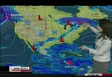
high pressure, pushing down from eastern canada.eantime, across the nation, a front through the miwest. the front may get close to us on thursday, may give us a passing shower. rockies cleared out. lookat this picture from the central rockies, sent in from kathy, who lives near grand lake. at 8,000 feet. the aespn are in peak color, we will see color here, not until late october. first, we have to get the high pressure out of here, in the next four hours. tap heat that today is building throughut tennessee and georgia, alabama, many areas above 90. it will get that way here tomorrow. rhaps, wednesday into thursday morning, it will wash out, probably no chance of rain until the weekend. quite a bit of sunshine. and overnight, clearing out, a beautiful, bright jupiter in our sky. it is closing to, weon't be this close to jupiter until 2022. last night, showing jupiter with four of the largest moons. >> up here. hot on friday. cooler on saturday, nar 80. sunday and monday, into the 70s extended outlook, not that accurate, at the closer
high pressure, pushing down from eastern canada.eantime, across the nation, a front through the miwest. the front may get close to us on thursday, may give us a passing shower. rockies cleared out. lookat this picture from the central rockies, sent in from kathy, who lives near grand lake. at 8,000 feet. the aespn are in peak color, we will see color here, not until late october. first, we have to get the high pressure out of here, in the next four hours. tap heat that today is building...
176
176
Sep 28, 2010
09/10
by
WRC
tv
eye 176
favorite 0
quote 0
between now and then, a weak area of low pressure, up into eastern canada.that will dry things out, and over the next 48 hours. a respite for a while. the ground is saturated. here comes the next surge of rain wednesday night into thursday. and this area of yellow, hel downpours sweeping across the day on thursday and exiting on friday. for tuesday, partly sunny, and blustery, highs to near 80. the winds settling down. we could have strong storms then, overnight, partly cloudy sky, temperatures near 60. still could be wet this evening on the shore. sun in the morning, highs reaching the 70s, and wednesday into thursday, we cou get tropical heavy downpours, out of here by thursday night. nd morning lows, afternoon highs, mid 70s, and over the weekd, morns in the 40s, and mid 60s saturday, sunday and monday. >> we will check the midday traffic. >> road work in place in advertently. live look along thei-95 corridor, the bulk of the construction on the southbound side, as you head down continuing to woodbridge, today, the rit side tied up. h.o.v. lanes configure
between now and then, a weak area of low pressure, up into eastern canada.that will dry things out, and over the next 48 hours. a respite for a while. the ground is saturated. here comes the next surge of rain wednesday night into thursday. and this area of yellow, hel downpours sweeping across the day on thursday and exiting on friday. for tuesday, partly sunny, and blustery, highs to near 80. the winds settling down. we could have strong storms then, overnight, partly cloudy sky, temperatures...
335
335
Sep 25, 2010
09/10
by
KCSM
tv
eye 335
favorite 0
quote 0
now, on to the rest of north america, very strong system across eastern canada here. that will also bring some cooler weather into the eastern united states. although it is dry right now and very warm for the east coast. i'll show you that in a second. interior portions of the u.s., really quiet right now, but as we head further to the west, you can see this area of pink here. that is going to be very heavy rain and gale force winds. pacific storm system moving in to parts of british colombia. so rain for you in vancouver. and really all into interior areas as well. 16 for your high. winnipeg is going to be around 15. 21 in chicago and 30 degrees, very summery, for those 30s across the east. now, looking at europe, well, it is going to be kind of messy if you're anywhere in western europe right now. this big complex of storms, anywhere from southern scandinavia down to the central mediterranean is really under the gun for wet weather, potentially severe weather, especially near the alpine parts as well. so stormy here, potentially severe gusts, hail, and lightning also
now, on to the rest of north america, very strong system across eastern canada here. that will also bring some cooler weather into the eastern united states. although it is dry right now and very warm for the east coast. i'll show you that in a second. interior portions of the u.s., really quiet right now, but as we head further to the west, you can see this area of pink here. that is going to be very heavy rain and gale force winds. pacific storm system moving in to parts of british colombia....
169
169
Sep 20, 2010
09/10
by
WRC
tv
eye 169
favorite 0
quote 0
it will bring some rain in extreme eastern canada, but that's about it. the storm is just about over with. so as far as the forecast goes for today, there goes igor. and the nation's kind of split. the southeast, the deep south, very hot. still feels like summer out there. some record highs are possible. there's a cooler air mass that has settled over the great lakes and new england. so it's definitely a split forecast. you can see chicago, 75. atlanta, 91. so we're still i the 90s from texas to orida. more or less in the late summer/fall air mass as you'd expect from chicago, detroit, all the way into areas of the east. but it's quiet today. not a lot of wet weaer. that's a look at your monday forecast. now here's a look at the weather outside your window. sunshine, another 90 degree day possible in raleigh, north carolina. houston today, very warm. we had a lot of heavy rain over the weekend in south texas. that should slowly improve today. some shows in t forecast. lynn, we'll sneak in to fall this week. give you the forecast coming up. >> it's here. a
it will bring some rain in extreme eastern canada, but that's about it. the storm is just about over with. so as far as the forecast goes for today, there goes igor. and the nation's kind of split. the southeast, the deep south, very hot. still feels like summer out there. some record highs are possible. there's a cooler air mass that has settled over the great lakes and new england. so it's definitely a split forecast. you can see chicago, 75. atlanta, 91. so we're still i the 90s from texas...
265
265
Sep 14, 2010
09/10
by
KCSM
tv
eye 265
favorite 0
quote 0
that extends across a lot of eastern canada as well. as for highs today, we're looking at 32 in atlanta, 32 also in miami. pretty hot in houston as well. up towards winnipeg, a high of 16 degrees. morning hours expected to be a lot chillier. we are looking at frost advisories in effect for you. a pretty interesting picture we've got coming in. this was taken from the international space station on monday. this is hurricane igor. you can see a well-formed eye toward the center. it is definitely a major hurricane to contend with. it's still a category 4 storm system packing winds of up to 240 kilometers per hour. gusts will be much, much higher. luckily, it ke manz well offshore in the atlantic. forecasts are calling for it to remain out in the sea. it's expected to remain its strength well into wednesday. it looks like it might start moving into bermuda later on this week. we'll keep a close eye on its progress. tropical storm juliet following behind igor moving away right now. likely becoming a hurricane in the next couple of days and h
that extends across a lot of eastern canada as well. as for highs today, we're looking at 32 in atlanta, 32 also in miami. pretty hot in houston as well. up towards winnipeg, a high of 16 degrees. morning hours expected to be a lot chillier. we are looking at frost advisories in effect for you. a pretty interesting picture we've got coming in. this was taken from the international space station on monday. this is hurricane igor. you can see a well-formed eye toward the center. it is definitely...
227
227
Sep 8, 2010
09/10
by
KCSM
tv
eye 227
favorite 0
quote 0
toward the northeast it's also quite a stormy night especially around the great lakes into eastern canada looking at heavy rains as well as damaging winds, even large hail, and tornadoes, too, could erupt. behind it we've got cold air coming in from canada. that's going to drop temperatures significantly across the northern tier and then also into the great lakes. we also have some more showers for british columbia, the pacific northwest, that will eventually make its way eastward and it will be developing later on in the week. 18 degrees in vancouver today, 18 in seattle and winnipeg 18 for you as well. here is the extended forecast now. >>> taking a look at our top stories once again the latest u.s. media poll shows that the public approval rate for u.s. president barack obama has fallen below 50% for the first time since he took office. in a joint poll by abc news and "the washington post" last week obama's public approval rating stood at 46%. this is down more than 20 percentage points from february, 2009, shortly after obama became president. on the economy nearly 70% said he is maki
toward the northeast it's also quite a stormy night especially around the great lakes into eastern canada looking at heavy rains as well as damaging winds, even large hail, and tornadoes, too, could erupt. behind it we've got cold air coming in from canada. that's going to drop temperatures significantly across the northern tier and then also into the great lakes. we also have some more showers for british columbia, the pacific northwest, that will eventually make its way eastward and it will...
261
261
Sep 9, 2010
09/10
by
KRCB
tv
eye 261
favorite 0
quote 0
a separate system to the northeast is making its way into eastern canada. we've got drenching downpours forecast for you. it's going to be quite windy out here and also the cold air ushering from the north will be dropping temperatures dramatically up in the northeastern corner. looking quite chilly and windy as well out towards the west. we do have red flag warnings in place across the central rockies, and then this low pressure system moving through is going to be dumping lots of rain, it's looking quite severe as well as that storm system heads into the northern plains. let's take a look at the temperatures then, 18 degrees in vancouver today, 20 in winnipeg. 24 in new york, but staying very hot down in the south, 34 degrees in houston. now a new storm system has formed over the atlantic, it's tropical depression igor making its way through the cape verde islands, bringing quite stormy continues here. it will be moving away eventually, moving fairly slowly at 9 kilometers per hour, and due to become a hurricane by the weekend, so we will keep you updated
a separate system to the northeast is making its way into eastern canada. we've got drenching downpours forecast for you. it's going to be quite windy out here and also the cold air ushering from the north will be dropping temperatures dramatically up in the northeastern corner. looking quite chilly and windy as well out towards the west. we do have red flag warnings in place across the central rockies, and then this low pressure system moving through is going to be dumping lots of rain, it's...
280
280
Sep 9, 2010
09/10
by
KCSM
tv
eye 280
favorite 0
quote 0
also lots of heavy rain coming into eastern canada as well. the northern plains looking at severe weather conditions to move on through on your thursday. this storm system getting ready to become better organized, moving across the northern rockies just now, and creating very windy conditions and a lot cooler conditions as well across the west. 17 degrees in seattle today. 20 in winnipeg. toronto in the teens today, 19 degrees. new york and washington, d.c. in the mid 20s. much cooler here. as for europe, central portions dealing with lots of showers, isolated heavy rain, and thunderstorms really affecting the alps and also the balkans as we head into your thursday. still looking quite windy across germany and poland as well. the british isles getting a bit of a break in the wet weather. as you can see, a new system is going to be pulling in from the atlantic. again, it will be drenching the area, bringing strong winds as well. 21 degrees in london today. sunny spells for you. 21 in paris. then looking at sunshine in stockholm. 16 degrees. and
also lots of heavy rain coming into eastern canada as well. the northern plains looking at severe weather conditions to move on through on your thursday. this storm system getting ready to become better organized, moving across the northern rockies just now, and creating very windy conditions and a lot cooler conditions as well across the west. 17 degrees in seattle today. 20 in winnipeg. toronto in the teens today, 19 degrees. new york and washington, d.c. in the mid 20s. much cooler here. as...
291
291
Sep 28, 2010
09/10
by
KRCB
tv
eye 291
favorite 0
quote 0
starting to head into the mid-atlantic states, new england region and it will impact parts of eastern canada as well. now canada also looking at more rain moving in off the west here. so british columbia, and then quickly moving into the rest of central canada, too, scattered showers for you. down towards the south, still pretty unsettled picture anywhere from the florida peninsula, across the caribbean islands and central america still continuing to see some significant amounts of rainfall, especially in southern mexico here, we're still seeing some pink areas showing up. heavy rainfall amounts are going to be expected. highs today looking at mid to upper 20s across the east coast, a little cooler for chicago only 19. it gets a little hotter during the day in denver, a high of 34, and l.a. still dealing with some of the late summer heat. and finally a look at europe. it's still pretty unsettled for continental europe. we've got this long frontal boundary in place, that is where a lot of the rain will be today. starting to head more north in towards the baltic states as well as spreading rea
starting to head into the mid-atlantic states, new england region and it will impact parts of eastern canada as well. now canada also looking at more rain moving in off the west here. so british columbia, and then quickly moving into the rest of central canada, too, scattered showers for you. down towards the south, still pretty unsettled picture anywhere from the florida peninsula, across the caribbean islands and central america still continuing to see some significant amounts of rainfall,...
143
143
Sep 22, 2010
09/10
by
KRON
tv
eye 143
favorite 0
quote 0
hurricane igor is that the eastern canada with heavy rain washed out roads and fighting holmes.ire in utah is still a problem, these trees are watching for any hot spots nang and a half the evacuation orders were lifted asters are able to get at least six square mile fire 50 percent contained members of the national guard accidentally started that fire on sunday. they were shooting danced during a training gel and the middle of dry and windy weather. people live in the area are furious same as the ground is waiting to happen >>> over 34 years we have watched and just waitç it to se fire coming of the rage that if i happen. i'm for that to say they check the weather conditions is a lie. it was a hot dry winds last night in lolly get here. >> representatives of the national guard had apologizing those responsible will be held accountable for what happened to the fire destroyed three homes and forced the evacuation of 16 and there's this evacuation orders have been lifted. attend the japan is not on that engine said in paris said the socialites those elements as japanese officials
hurricane igor is that the eastern canada with heavy rain washed out roads and fighting holmes.ire in utah is still a problem, these trees are watching for any hot spots nang and a half the evacuation orders were lifted asters are able to get at least six square mile fire 50 percent contained members of the national guard accidentally started that fire on sunday. they were shooting danced during a training gel and the middle of dry and windy weather. people live in the area are furious same as...
160
160
Sep 22, 2010
09/10
by
KRON
tv
eye 160
favorite 0
quote 0
igor has been halting eastern canada washing out roads and flooding homes. >> so wild file fire in utahey're watching for hot spots. half the evacuations were listed last night. it is 50 percent contained some national guard started the fire on sunday will shooting guns on during the trading drawl. people are furious saying this was a problem waiting to happen. >> bedbugs are reaching an epidemic club all across the country. the lead to a first ever bedbug summit. the sold-out event featured but experts birds exterminators the scientists all trying to combat the source of bedbugs. there is chemical control options you can turn to but some of them are not effective. says the recent resurgence has led to innovative methods for controlling >> people can go for professional pest control that segment of the mark global market is responding to the need. there are various things you can do you complete plastic casing on a mattress to reduce the numbers of places bedbugs can hide. there are kinds of things that can be installed on legs of beds. things like clothing and other objects in the hous
igor has been halting eastern canada washing out roads and flooding homes. >> so wild file fire in utahey're watching for hot spots. half the evacuations were listed last night. it is 50 percent contained some national guard started the fire on sunday will shooting guns on during the trading drawl. people are furious saying this was a problem waiting to happen. >> bedbugs are reaching an epidemic club all across the country. the lead to a first ever bedbug summit. the sold-out event...
240
240
Sep 29, 2010
09/10
by
WJZ
tv
eye 240
favorite 0
quote 0
the storm factors taking a big dip and that's picking up the moisture and moving up towards eastern canada next 12 to 24 hours. there's a small craft advisory in the bay and bay temperature around 75. there's a wind moving in and breezy and 65 is the low. tomorrow, rain, heavy and maybe a thunderstorm and gusty winds and maybe up to 25 to 35 miles per hour winds. we're talking about power outages and that's if we get the heavy rains. we'll have a narrow band and it's 75 miles wide where we hit the rainfalls. exact will where that will be determines where we'll get the flooding issues. >> it's full of the good news. >> and it's all over tomorrow night. >> still to come, two big stories on a massive tropical system pushes rain towards maryland. >>> also, a deadly bus accident >>> also, a deadly bus accident with a dozen injured. ,,,, old gibbs canning company. >>> also, a deadly bus accident with a dozen injured. ,,,, today these factories are full of dot com businesses. and now my job is helping maryland create new economy jobs. training new math and science teachers investing in our instit
the storm factors taking a big dip and that's picking up the moisture and moving up towards eastern canada next 12 to 24 hours. there's a small craft advisory in the bay and bay temperature around 75. there's a wind moving in and breezy and 65 is the low. tomorrow, rain, heavy and maybe a thunderstorm and gusty winds and maybe up to 25 to 35 miles per hour winds. we're talking about power outages and that's if we get the heavy rains. we'll have a narrow band and it's 75 miles wide where we hit...
230
230
Sep 21, 2010
09/10
by
WRC
tv
eye 230
favorite 0
quote 0
we'rfeeli some of that chill here wh hi presse pushing down from eastern canada through the mid atlantic states. clear sky. plenty of sun. it should get us up to near 80 by afternoon. and then cool tonight. not as chilly as this morning. warming up with a southwesterly breeze. it will keep it on the summery side. jerry, how is the traffic? >> we continue to follow breaking news where the accidt remains two right lanes remain closed. all this occurred on the inner loop of the beltway between i-66 and route 7. two left lanes get by. it's jammed leaving springfield all the way up. unfortunatel there is no shoulder because that's part of the construction zone there. we have to wait for the tow trucks to get there. can't move the cars out until the tow trucks arrive a pull them out completely. be forewarned. from springfield to 66 it is a nightmare. over on 66, because of the location of t accident, making for an extremely difficult merge coming in on 66 trying to get on to or beyond the capital beltwy. 66 delays begin centerville most of the way in. that, too, is a parking lot. drop down rou
we'rfeeli some of that chill here wh hi presse pushing down from eastern canada through the mid atlantic states. clear sky. plenty of sun. it should get us up to near 80 by afternoon. and then cool tonight. not as chilly as this morning. warming up with a southwesterly breeze. it will keep it on the summery side. jerry, how is the traffic? >> we continue to follow breaking news where the accidt remains two right lanes remain closed. all this occurred on the inner loop of the beltway...
349
349
Sep 4, 2010
09/10
by
KCSM
tv
eye 349
favorite 0
quote 0
but we'll see heavy rain heading up into eastern parts of canada. temperaturewise, hot in the southwest. and up to the east. but those temperatures should come down by quite a bit on saturday. all right. let's take a look at europe. most of the continent is going to be dry and settled on the weekend. but down in the south, we have been dealing with severe storms. good news is they're going to start to weaken and head out towards the southern portion of the balkans. ireland, you could be seeing fairly strong wind and heavy rain in the next couple of days. but it should weaken off. this is actually -- used to be hurricane danielle, if you remember that one. this the remnants and it's going to spill over ireland but weakening as it goes. temperatu temperaturewise, things on the cool side. 14 in staockholstockholm. better in paris. warmer in the south. 30s for athens, madrid and lisbon. here's your extended forecast. >>> twin giant pandas have been thrown to the media for the first time since they were born at a zoo in western japan. the adventure world
but we'll see heavy rain heading up into eastern parts of canada. temperaturewise, hot in the southwest. and up to the east. but those temperatures should come down by quite a bit on saturday. all right. let's take a look at europe. most of the continent is going to be dry and settled on the weekend. but down in the south, we have been dealing with severe storms. good news is they're going to start to weaken and head out towards the southern portion of the balkans. ireland, you could be seeing...
178
178
Sep 21, 2010
09/10
by
KCSM
tv
eye 178
favorite 0
quote 0
across the eastern third of the u.s. and canada, looking generally calm and dry. central areas dealing with very windy conditions today. red flag warnings in place across the rockies and towards the north. the storm system likely to kick up a few strong thunderstorms in minnesota. relatively cool across central and western canada and down in the south. still dealing with lots of showers and lots of heavy rain in place across mexico after hurricane karl made landfall of friday. remnants causing havoc on. 25 degrees in mexico city today with heavy rain, stays hot in houston. 33. 31 up in chicago. it will be quite cool in winnipeg and vancouver. that's what's going on just now. here is your extended forecast now. >>> that's all for this edition of "newsline." i'm catherine kobayashi in tokyo. thanks for joining us.
across the eastern third of the u.s. and canada, looking generally calm and dry. central areas dealing with very windy conditions today. red flag warnings in place across the rockies and towards the north. the storm system likely to kick up a few strong thunderstorms in minnesota. relatively cool across central and western canada and down in the south. still dealing with lots of showers and lots of heavy rain in place across mexico after hurricane karl made landfall of friday. remnants causing...
322
322
Sep 3, 2010
09/10
by
KRON
tv
eye 322
favorite 0
quote 0
it's not expect to make landfall until canada along the eastern seaboard hurricane watches and warnings are in fact. n.c. have declared a state of emergency. >> our national guards activated. >> businesses already taking a beating economically. >> this couldn't come at a worse time. labor day is our last of our weekend for the summer. it's hard. >> hours before the approach they took of manager of the waves which are expected to surge as the work strom goes by. >> got out of school so makes a good thing. i'm excited about the wind and rain tariffs >> it will be going along the east coast president barack obama will be getting up of data about their retains a truck tractors and any possible damage. >> live pictures coming in to the newsroom nor n.c. and the other from new jersey the shore line here is a live look on the left-hand side the shoreline near north carolina on the right-hand side alive reporter live shot talking about what it's like in new jersey in north carolina we have high water starting to come and one-2 ft. of water covering roadways there. loose debris floating in the s
it's not expect to make landfall until canada along the eastern seaboard hurricane watches and warnings are in fact. n.c. have declared a state of emergency. >> our national guards activated. >> businesses already taking a beating economically. >> this couldn't come at a worse time. labor day is our last of our weekend for the summer. it's hard. >> hours before the approach they took of manager of the waves which are expected to surge as the work strom goes by. >>...
316
316
Sep 29, 2010
09/10
by
MSNBC
tv
eye 316
favorite 0
quote 1
eastern seaboard. flood watches through canada and mid-atlantic and boston area won't be too bad with this one. how much rainfall we are expecting with this storm and adding it up as it goes in time here and the possibility of a six to seven inch localized rain event in areas of new jersey and new york city and that would be a big deal as far as the timing goes. starts tonight in d.c., some light rain and the real significant rains early tomorrow morning. the morning commute around d.c., philly and also baltimore will be bad. new york the heavy rain will just be moving in. tomorrow afternoon and evening the heaviest delays and d.c., philly to new york and getting into heaartford and wraps up thursday night into friday morning. it's a weird event. almost like a nor'easter type storm. just a very heavy rain event. a storm we would see in the spring -- >> it's a weird fall. let's just say that. >> i like a quiet fall, but the leaves first. >> doesn't this make that? >> we'll appreciate it later. >> thank you. >>> there are some frightening moments aboard a skywest airlines plane. they had to make
eastern seaboard. flood watches through canada and mid-atlantic and boston area won't be too bad with this one. how much rainfall we are expecting with this storm and adding it up as it goes in time here and the possibility of a six to seven inch localized rain event in areas of new jersey and new york city and that would be a big deal as far as the timing goes. starts tonight in d.c., some light rain and the real significant rains early tomorrow morning. the morning commute around d.c., philly...
292
292
Sep 24, 2010
09/10
by
KNTV
tv
eye 292
favorite 0
quote 0
eastern half of the country. cooler air coming down from canada. the west coast, you have been cool as of late, but at warm-up this weekend. a big front in the middle of the country, dividing the air to the east. another system in the northern rockies and another big storm in the gulf of alaska affecting mostly british columbia a few clouds from seattle to the puchapucget sound. it will be warm. temperatures are going to jump especially saturday into sunday. the only cool spot behind this little clipper-type system that's really moving fast through the northern rockies. the forecast for today, as i mentioned, the only chilly air up in seattle. everybody else, mild. beautiful around boise and vegas, nice. 96. you'll get hotter. phoenix, back up into the triple digits. los angeles, beautiful, warm weather, middle of summer-type weather over the next couple of days. into the 90s in most areas by saturday and sunday. san francisco, some of the most beautiful weather you've seen. 82 and sunny. we couldn't buy that. roseburg, oregon, 79 and sunny. one of
eastern half of the country. cooler air coming down from canada. the west coast, you have been cool as of late, but at warm-up this weekend. a big front in the middle of the country, dividing the air to the east. another system in the northern rockies and another big storm in the gulf of alaska affecting mostly british columbia a few clouds from seattle to the puchapucget sound. it will be warm. temperatures are going to jump especially saturday into sunday. the only cool spot behind this...
204
204
Sep 21, 2010
09/10
by
KTVU
tv
eye 204
favorite 0
quote 0
has been downgraded to a tropical storm causing high surf along the eastern seaboard tonight as it heads north to newfoundland, canada. bermuda is cleaning up the storm which was still at hurricane strength when it brushed the island. the storm surge pushed sand into some buildings. the only reported death from the storm recorded yesterday from a man surfing off the carolina coast. >>> bill martin is here to talk to us about fall coming up ahead. >> it wasn't that hot but it felt hot, didn't it? a little bit of humidity left in the air. sprinkle activity. temperatures are trending down. they will be the warmest day for a couple of days. as we go outside, i will show you where we are in temperatureland. we have 80 in santa rosa. 77 in san jose. temperatures tomorrow at this time will be about 4 degrees dealer. these are the highs from today, highs tomorrow, cool he. it felt a lot warmer than 81 in antioch. 81 in livermore but it was a function of the humid imported over the weekend as the weather system slid through here and didn't deposit much in the way of rainfall. but it was moist and drizzly. today, temperatures
has been downgraded to a tropical storm causing high surf along the eastern seaboard tonight as it heads north to newfoundland, canada. bermuda is cleaning up the storm which was still at hurricane strength when it brushed the island. the storm surge pushed sand into some buildings. the only reported death from the storm recorded yesterday from a man surfing off the carolina coast. >>> bill martin is here to talk to us about fall coming up ahead. >> it wasn't that hot but it felt...
217
217
Sep 20, 2010
09/10
by
FOXNEWS
tv
eye 217
favorite 0
quote 0
hurricane igor causing high surf and powerful currents along the eastern seaboard, as the storm heads north to canadary one hurricane, maximum sustained winds, 75 miles per hour. the winds did a job on bermuda over the weekend. the storm smashing in the island yesterday. knocking boats off the mooring, slamming trees to the ground. our senior correspondent rick leventhal was there as igor started to make his presence known. >> a close-up look at the violent waves that are hitting bermuda southern coast with worst of hurricane igor several hours away. we're seeing storm surge and pretty rough conditions. >> the rough surf has already chewed away several feet of sand at the coconut restaurant at the reef hotel. you can see the rocks exposed because the beach used to be several feet higher, up to the base of the platform here. and the few hotel guests that are still here have been moved to the more secure area, the condos high on the cliff to keep them out of harm's way. >> shepard: that was yesterday. cross over now live to rick leventhal streaming from south hampton in bermuda. how bad does it look to
hurricane igor causing high surf and powerful currents along the eastern seaboard, as the storm heads north to canadary one hurricane, maximum sustained winds, 75 miles per hour. the winds did a job on bermuda over the weekend. the storm smashing in the island yesterday. knocking boats off the mooring, slamming trees to the ground. our senior correspondent rick leventhal was there as igor started to make his presence known. >> a close-up look at the violent waves that are hitting bermuda...
343
343
Sep 10, 2010
09/10
by
KCSM
tv
eye 343
favorite 0
quote 0
heading into the northern plains and central canada next it will be bringing isolated heavy rain and also some severe thunderstorms to watch out for. over towards easternuebec still quite stormy for you tonight, and also on your friday, temperatures a little chilly as well across the midwest, looking at 23 degrees in new york today, 20 in toronto, and then 15 degrees up in winnipeg. finally over to europe then, a slow moving system has finally made its way down into the m mediterrane mediterranean, it will be stormy across the central mediterranean into the weekend, looking at lots of thunderstorms, heavy rain falling on friday, along the west coast of the balkans as well as southern italy. meanwhile this high pressure system expanding from the iberian peninsula is going to help bring dry conditions to central europe, so the weekend is looking good for you here, but the northwest, the british isles looking at wet and windy weather once again. it's going to be moving into southern scandinavia next as well by friday morning. 16 degrees in stockholm today, 20 degrees in london, coming in at 27 in madrid, teens, 18 degrees in berlin today. that's what's go
heading into the northern plains and central canada next it will be bringing isolated heavy rain and also some severe thunderstorms to watch out for. over towards easternuebec still quite stormy for you tonight, and also on your friday, temperatures a little chilly as well across the midwest, looking at 23 degrees in new york today, 20 in toronto, and then 15 degrees up in winnipeg. finally over to europe then, a slow moving system has finally made its way down into the m mediterrane...
469
469
Sep 11, 2010
09/10
by
KCSM
tv
eye 469
favorite 0
quote 1
eastern kansas as well as missouri. picks up steam from another system here and still bringing drenching rains. now, the system, in fact, extends up towards central canada, manitoba, saskatchewan, any cells could bring severe, isolated storms. the upper midwest into the lower midwest, hail, strong gusts, very -- lots of lightning and downpours quite heavy at times. east coast looking to dry out. towards the west, also quiet here. although there does seem to be rain moving into british columbia. here's a look at how temperatures are on friday. 14 degrees in winnipeg. chilly for you. 27 in denver. hot and muggy in houston. miami, 33. 23 in new york city. more autumnal there. last, let's head over to europe. western europe, looking nice. calm conditions here. also eastern europe, though really, really calm all week, things are going to change. i'll show you why. look at this cloud here. underneath itti a couple of strg systems. the pesky, low pressure system not moving too much. still bringing hard rain across parts of southern italy. now the storms are shifting their way in towards greece as well. and that stormy weather also affecting parts of austria, h
eastern kansas as well as missouri. picks up steam from another system here and still bringing drenching rains. now, the system, in fact, extends up towards central canada, manitoba, saskatchewan, any cells could bring severe, isolated storms. the upper midwest into the lower midwest, hail, strong gusts, very -- lots of lightning and downpours quite heavy at times. east coast looking to dry out. towards the west, also quiet here. although there does seem to be rain moving into british columbia....
70
70
Sep 19, 2010
09/10
by
WBFF
tv
eye 70
favorite 0
quote 0
eastern seaboard especially the mid-atlantic although that's typical. jet stream to monday, there's very chilly to cold air across much of canada and hot and humid in the southern parts of this country. as long the jet stream remains zonal like it will be we won't see any big intrusion of cold air into this country. we'll have cool air masses coming southward in the northern states but all in all that does not look that cold. there are signs that maybe down the road we will see the jet stream dip in the plains in the northeast, more than a week away though before that would probably happen according to the models right now. let's go day by day, on monday as we head through the ladder portions of september into fall obviously, official fall does arrive this week, you can see showers up across the northern plain states back into the portions of the central rockies just hit-and-miss showers and thunderstorms in the muggy air to the front and lit continue to be muggy. by wednesday we will see everything quickly shifting quickly northeast and you can see the warm front in new england and cold front dips and stalls out across the central plains and showers a
eastern seaboard especially the mid-atlantic although that's typical. jet stream to monday, there's very chilly to cold air across much of canada and hot and humid in the southern parts of this country. as long the jet stream remains zonal like it will be we won't see any big intrusion of cold air into this country. we'll have cool air masses coming southward in the northern states but all in all that does not look that cold. there are signs that maybe down the road we will see the jet stream...
245
245
Sep 2, 2010
09/10
by
KOFY
tv
eye 245
favorite 0
quote 0
canada. >> we're heading back. >> 18 hours. >> yes, 18 hours, straight. >> one road off the island was a slow moving mess. storm is fearsome and going to skirt the eastern coastline. >> there have been times when people had sworn to us it's not going to touch us. within three hours it's right on top of us. >> fema is shipping supplies and 300,000 meals to north carolina and massachusetts. >> we could see watching and warnings up the east coast. it's important for residents to have an evacuation plan ready to go if it's called for. >> fema says residents from north carolina to maine should look out for a moving wall of water that could do terrible things in low-lying areas. this is cape cod in the path of earl and home to half a million summer residents. >> meteorologist sandhya patel is here and watching earl. what is it doing right now? >> it's stronger than just a few hours ago, now packing winds of 140 miles an hour. >> that is strong. >> it has an eye on north carolina. let's get you outside. from the east bay hills camera, winds outside relatively light. in some areas it's just calm. and the view is sparkling, it's clear across the entire bay area
canada. >> we're heading back. >> 18 hours. >> yes, 18 hours, straight. >> one road off the island was a slow moving mess. storm is fearsome and going to skirt the eastern coastline. >> there have been times when people had sworn to us it's not going to touch us. within three hours it's right on top of us. >> fema is shipping supplies and 300,000 meals to north carolina and massachusetts. >> we could see watching and warnings up the east coast. it's...
211
211
Sep 20, 2010
09/10
by
WRC
tv
eye 211
favorite 0
quote 0
eastern shore away from the waters right now near 70. e view from space over the last 12 hours showing a northerly flow coming down from canada as high pressure noses down. it's cleared out our sky. we'll ve plenty of sunshine for the rest of the afternoon. it will be mild, a bit blustery at times, winds gusting to 10 to 25 miles an hour as highs reach the upper 70s to near 80 by midafrnoon. a look at the rest of the week, somehanges on the way as well as the weekend, and we'll look at the troipics, too. that's coming up. t? >> thanks, tom. >>> let's head to the roads now and check out the traffic this midday. jerry edwards is with us from the news 4 traffic network. hey, jry. >> hey, pat. good morning to you. good morning, everyone. well, construction crews have taken an additional travel lane for the midday along 395 northbound, 14th street bridge, not uncommon. delays will begin just about at the pentagon. right now there are two lanes. when you get on the bridge, additional lane or two, once you get about midspan, delays begin well after the pentagon. not too much in the way of a backup at this hour. good news there. making the trip to so
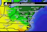
eastern shore away from the waters right now near 70. e view from space over the last 12 hours showing a northerly flow coming down from canada as high pressure noses down. it's cleared out our sky. we'll ve plenty of sunshine for the rest of the afternoon. it will be mild, a bit blustery at times, winds gusting to 10 to 25 miles an hour as highs reach the upper 70s to near 80 by midafrnoon. a look at the rest of the week, somehanges on the way as well as the weekend, and we'll look at the...
 Live Music Archive
 Librivox Free Audio
 Metropolitan Museum
 Cleveland Museum of Art
 Internet Arcade
 Console Living Room
 Open Library
 American Libraries
 TV News
 Understanding 9/11