184
184
Mar 3, 2012
03/12
by
WUSA
tv
eye 184
favorite 0
quote 0
this is some nasty activity in west virginia, eastern kentucky and also into ohio. you see the big area shaded in red, that is the tornado watch boxes. the areas that are in bright red are actually under tornado warnings this hour and we know they have tornadoes because this is the same line that produced the tornadoes in henryville, indiana just of louisville. so a tremendous amount of energy and instability. look at all the lightning pop up just west of charleston up toward ripley. the good news is we are on the stable end of the environment, so we don't see anything severe happening tonight. we will watch it carefully getting into the midnight hour. we will see milder air roll in and the atmosphere will destablize a little here. look at the storm reports. these are tornadoes. we have hail, all kinds of activity through much of ohio, southern indiana, southern illinois and it continues to march off to the east. in fact, an unconfirmed tornado now around huntington with a severe thunderstorm. we'll move off to the east. here's our first batch of rain and showers. s
this is some nasty activity in west virginia, eastern kentucky and also into ohio. you see the big area shaded in red, that is the tornado watch boxes. the areas that are in bright red are actually under tornado warnings this hour and we know they have tornadoes because this is the same line that produced the tornadoes in henryville, indiana just of louisville. so a tremendous amount of energy and instability. look at all the lightning pop up just west of charleston up toward ripley. the good...
298
298
tv
eye 298
favorite 0
quote 0
the bright white area is snow reaching from roanoke to charleston in west virginia and into eastern kentucky. that's a weak area of low pressure, going to be passing to the south. we have a winter weather advisory. it includes the nearby counties of spotsylvania, orange, points south. this winter weather advisory in effect until noontime. and locally, we might have just a few flurries around the metro area by mid morning and during the middle of the day. temperatures climbing to near 40 at noontime. a blustery wind this afternoon. the sky clearing this afternoon and evening. sunset at 6:06. clear and cold, near freezing by midnight. a look at the rest of the week and some of the snow totals. more in ten minutes. danella? >>> traveling i-66, seeing nothing but green. meaning nothing really slowing you down yet. your volume's very light. and some of you are actually speeding really fast. 71 miles per hour eastbound out of haymarket. slower, 63 passing centreville. in fact, as you make your commute east and west on i-66 outside of the beltway, no issues inside of the beltway. we'll take a live
the bright white area is snow reaching from roanoke to charleston in west virginia and into eastern kentucky. that's a weak area of low pressure, going to be passing to the south. we have a winter weather advisory. it includes the nearby counties of spotsylvania, orange, points south. this winter weather advisory in effect until noontime. and locally, we might have just a few flurries around the metro area by mid morning and during the middle of the day. temperatures climbing to near 40 at...
184
184
Mar 4, 2012
03/12
by
FOXNEWSW
tv
eye 184
favorite 0
quote 0
we do have some flurries, flying around in indiana and eastern kentucky.ve a short wave that will be moving on toward the east, towards the areas that did get hit hard with the tornadoes. so we will be looking at accumulating snowfall late tonight and tomorrow. with accumulations between 1-3 inches expected. >> gregg: thanks very much. to syria, humanitarian aid reaching some families in the rubble stronghold town in a city that has been the scene of brutal attacks by government forces for several weeks now. the army is said to be blocking the red cross from distributing food and blankets in one neighborhood, seized from rebels, just days ago. we are going to dominic in nearby lebanon. tell us about the turmoil now spilling into other parts of the middle-east? >> reporter: gregg, because syria is a pivotal country in this region, there are fears of how far that turmoil could spread. here in beirut, we saw demonstrations, the kind of which we haven't seen in the middle-east so far. we saw a faceoff between people, over sirria. as i say, one of the first tim
we do have some flurries, flying around in indiana and eastern kentucky.ve a short wave that will be moving on toward the east, towards the areas that did get hit hard with the tornadoes. so we will be looking at accumulating snowfall late tonight and tomorrow. with accumulations between 1-3 inches expected. >> gregg: thanks very much. to syria, humanitarian aid reaching some families in the rubble stronghold town in a city that has been the scene of brutal attacks by government forces...
259
259
Mar 2, 2012
03/12
by
WTTG
tv
eye 259
favorite 0
quote 0
and west, look at that line of rain showers and thunderstorms into eastern tennessee now and eastern kentucky. that is lifting towards the washington area. it's warm front. when it arrives mid- to late afternoon, we'll see some showers across the area. so be prepared here for some rain if you are going to be out all day. bring along an umbrella because i think we will see some rain by sunset tonight. 43 in washington. another story, it is much cooler than it was 24 hours ago. 3 in fredericksburg. 33degrees in ocean city. that is chilly. 3 # in winchester. identify change, we've got freezing temperatures at this moment in the morning. 32 in winchester. about 10 to 15 degrees cooler for daytime highs. we'll look at the weekend in a minute. >> right now though, let's check on what is going on on the roads. julie wright, good morning. >> good morning. not a lot happening right now. we had mentioned earlier accident activity westbound 7 at the eastern intersection. the accident activity is off to the shoulder and there is no delay. no trouble spots headed south out towards the split. lanes are ope
and west, look at that line of rain showers and thunderstorms into eastern tennessee now and eastern kentucky. that is lifting towards the washington area. it's warm front. when it arrives mid- to late afternoon, we'll see some showers across the area. so be prepared here for some rain if you are going to be out all day. bring along an umbrella because i think we will see some rain by sunset tonight. 43 in washington. another story, it is much cooler than it was 24 hours ago. 3 in...
389
389
tv
eye 389
favorite 0
quote 0
the worst damage is centered in southern indiana and eastern kentucky. scott goldberg reports. >> reporter: throughout clarks county in southern indiana, the devastation is overwhelming and total. >> once again, mother nature deeding with indiana. >> entire communities, homes, schools, and businesses are gone. >> we lost it. and we're with you. it's not just government. this is their neighbors here to help. >> the friday twisters threatened millions of people from the gulf coast to the great lakes. the national weather service issued nearly 300 tornado warnings on friday, making it one of the worst days in u.s. history. and it wasn't over. thunderstorms rocked georgia this morning, bringing more damage. the twisters struck so quickly and with such force that many barely had time to get away. >> we thought we had 11 minutes and within two seconds it came through and blew the house off the foundation. >> in henrysville it lifted the roof of the school while the students were inside. >> if you walked through my car and through that hallway right there, we w
the worst damage is centered in southern indiana and eastern kentucky. scott goldberg reports. >> reporter: throughout clarks county in southern indiana, the devastation is overwhelming and total. >> once again, mother nature deeding with indiana. >> entire communities, homes, schools, and businesses are gone. >> we lost it. and we're with you. it's not just government. this is their neighbors here to help. >> the friday twisters threatened millions of people from...
221
221
tv
eye 221
favorite 0
quote 0
. >> reporter: the tornado headed across the state line into eastern kentucky with a path of construction2 miles long. classifying it as f 4. >> it's in the violent category most tornadoes never come near to. >> reporter: one survivor is at a louisville hospital. they found the 2 year old in a field near her home. in ohio a twister tore up the town of moscow and at least one died in alabama with the first storm starting friday morning. back in henryville long time resident wayne jones will have to start by finding a new place to live. in henryville, indiana. >> president obama has called promising federal assistance in the recovery. >>> costa concordia ship wreck brings families back to italy. the luxury liner capsized with 25 bodies fulled from the sea and 70 people still missing. they're wondering if they should have manslaughter charges. he's accused of causing a wreck and then abandoning ship. >>> a 5 year old girl beaten to death. community comes together to remember the girl. weijia jiang has more on the latest from the case. weijia? >> reporter: there were as many adults as young o
. >> reporter: the tornado headed across the state line into eastern kentucky with a path of construction2 miles long. classifying it as f 4. >> it's in the violent category most tornadoes never come near to. >> reporter: one survivor is at a louisville hospital. they found the 2 year old in a field near her home. in ohio a twister tore up the town of moscow and at least one died in alabama with the first storm starting friday morning. back in henryville long time resident...
254
254
Mar 2, 2012
03/12
by
WTTG
tv
eye 254
favorite 0
quote 0
now pressing into eastern kentucky and tennessee. that will be moving in a little later this afternoon. so i think by 3:00, 4:00, 5:00 today, we'll have some showers and perhaps a thunderstorm moving back into the area here. we're going to time it out a little bit. temperatures, 42 in washington and lots of 30s on the map this morning. 36 in fredericksburg, ocean city, 33 degrees. clouds move in, showers return this afternoon. the showers will linger into the nighttime hours so if you've got evening plans be ready for some rain. highs in the upper 50s though. cooler than yesterday when we hit 70 for a daytime high. that's a quick look at the forecast. let's get some traffic and miss blue herself, julie wright. >>> it's 95 not a fun ride right now. the crew at sky fox helping us out with the delay. a nice pretty picture but unfortunately we just lost them. if you are traveling northbound along i-95 we have the delays coming northbound from quantity quo. all right we got them back heading northbound going up to what was the accident sc
now pressing into eastern kentucky and tennessee. that will be moving in a little later this afternoon. so i think by 3:00, 4:00, 5:00 today, we'll have some showers and perhaps a thunderstorm moving back into the area here. we're going to time it out a little bit. temperatures, 42 in washington and lots of 30s on the map this morning. 36 in fredericksburg, ocean city, 33 degrees. clouds move in, showers return this afternoon. the showers will linger into the nighttime hours so if you've got...
358
358
tv
eye 358
favorite 0
quote 0
and eastern kentucky. counties in lavender under a winter weather advisory for some light accumulating snow. the closest county to washington is spotsylvania under the winter weather advisory. for the metro area, here's your day planner. sunrise at 6:64. flurries moving -- 6:34. flurries moving in. low to mid 40s by late afternoon. winds will clear by late afternoon. and there may be a few flurries just around the metro area. a dusting to an inch, though. the area about 30, 40 miles to the south is where there may be accumulation on some grassy areas. a look at the seven-day outlook in ten minutes. danella has a look at traffic. good morning. >>> good morning. right now we have breaking news on the beltway in montgomery county. traveling on the beltway just past new hampshire avenue, we have a five-vehicle crash. it was blocking the left lane. fire rescue are on the scene now and have shut the beltway down. right now all lanes are blocked just past new hampshire avenue. a live look now. you see cars and tr
and eastern kentucky. counties in lavender under a winter weather advisory for some light accumulating snow. the closest county to washington is spotsylvania under the winter weather advisory. for the metro area, here's your day planner. sunrise at 6:64. flurries moving -- 6:34. flurries moving in. low to mid 40s by late afternoon. winds will clear by late afternoon. and there may be a few flurries just around the metro area. a dusting to an inch, though. the area about 30, 40 miles to the...
207
207
Mar 5, 2012
03/12
by
WUSA
tv
eye 207
favorite 0
quote 0
some snow showers in the mountains now of west virginia, eastern kentucky. but as this slides away from us, we'll see a little bit of sun in a couple of spots but also the threat this afternoon for not much more than a passing flurry or snow shower and maybe even a couple of rain showers well south of town. but we've got the cold air in place, just cold enough for the snow. by 6:00 tonight, the storms off shore. a couple of flurries are left over. that's about it. the warm-up begins tomorrow. so for today low 40s here. mostly cloudy. a couple of flurries may pass through the district and southern maryland. again another hour or two and you'll be done. milder tomorrow. after being in the 20s in the morning, we'll get to the low 50s. look at wednesday and thursday. mid-60s wednesday. upper 60s thursday. delightful. friday we may see a few showers and this weekend clocks go forward. time change the weekend but temperatures are looking up. 60 saturday. 65 sunday. stick around. 9news now at noon will return in just a moment. >>> open wide. if your dentist says yo
some snow showers in the mountains now of west virginia, eastern kentucky. but as this slides away from us, we'll see a little bit of sun in a couple of spots but also the threat this afternoon for not much more than a passing flurry or snow shower and maybe even a couple of rain showers well south of town. but we've got the cold air in place, just cold enough for the snow. by 6:00 tonight, the storms off shore. a couple of flurries are left over. that's about it. the warm-up begins tomorrow....
322
322
Mar 4, 2012
03/12
by
KPIX
tv
eye 322
favorite 0
quote 0
the tornado that tore through henryville headed across the state line into eastern kentucky. cutting a path of destruction 52-miles long. the national weather service is classifying it as f--4. >> as it in that violent category that most tornadoes never come near to. >> reporter: and young survivor is recovering at a louisville hospital. rescuers in salem, indiana found the 2-year-old anyway field here her home. in ohio, a twister tore and the area. back in hen rieville, long-time henryville is trying to stay positive. jones will have to start with finding a new place to live. susan mcginnis, henryville, indiana. >>> firefighters are clearing the scene of a apartment fire that broke out near the bayview area east of the highway 101 and 280 interchange. you can see flames shooting out from the roof. the red cross is helping those inside the home find a place to sleep tonight. >>> no word yet on a cause. >>> after an outcry by women and politicians, conservative radio personality rush limbaugh apologized for insults directed at a young woman who testified before congress. withi
the tornado that tore through henryville headed across the state line into eastern kentucky. cutting a path of destruction 52-miles long. the national weather service is classifying it as f--4. >> as it in that violent category that most tornadoes never come near to. >> reporter: and young survivor is recovering at a louisville hospital. rescuers in salem, indiana found the 2-year-old anyway field here her home. in ohio, a twister tore and the area. back in hen rieville, long-time...
159
159
Mar 28, 2012
03/12
by
WUSA
tv
eye 159
favorite 0
quote 0
here's where the heaviest showers and storms can be found through eastern kentucky and the southern 1/2 of west virginia, but we see more showers and thunderstorms crossing 81 and headed over toward fredericksburg and charlottesville. we'll zoom in with live doppler to the south and west. you're in leesburg, fairfax, montgomery county, you're done with showers tonight, but down toward culpeper you're not and by the way, old rag mountain has been hammered twice today and this is moving through now. this is moving southeastward towards fredericksburg and will produce pretty heavy rain, rainfall rates almost an inch as hour as it progresses off to the southeast in the next hour, it will cross 95 and cross fredericksburg and go across eventually into southern maryland. temperatures, 70 in arlington, 72 bethesda, 68 reston, 69 toward fort belvoir. we're drying out quickly. thunderstorms end by 8:00, breezy and cooler tomorrow, seasonable, nice friday and unsettled on saturday. so for tonight showers and storms ending early, partly cloudy, breezy and mild, lows around 50, winds becoming nor
here's where the heaviest showers and storms can be found through eastern kentucky and the southern 1/2 of west virginia, but we see more showers and thunderstorms crossing 81 and headed over toward fredericksburg and charlottesville. we'll zoom in with live doppler to the south and west. you're in leesburg, fairfax, montgomery county, you're done with showers tonight, but down toward culpeper you're not and by the way, old rag mountain has been hammered twice today and this is moving through...
208
208
Mar 28, 2012
03/12
by
WUSA
tv
eye 208
favorite 0
quote 0
so from eastern kentucky through our neck of the woods, west of 95, that's where we've got the threat for the severe weather from the storm prediction center. hail being a minor concern, damaging wind gusts with these storms being the more major concern. here's that line about 3:00, still north and west of d.c. it'll be coming through in the afternoon. look, it's kind of breaking up. so what we see is going to be some broken line of storms, but some potentially strong ones here fot for the afternoon and early evening and then cooler tonight with those northwesterly winds moving in. here's the forecast, mid-70s in d.c., some spots west near 80 with a few strong thunderstorms, kind of breezy. tonight we're down into the upper 40s and low 50s. winds go northwest 10 to 20. tomorrow breezy and cooler, high 61. friday 64 with some clouds increasing in the afternoon. i think by friday night into saturday a few showers around. saturday in the mid-60s. sunday and monday dry and warmer. look at that by monday, we're back to 82. we're going to the kitchen. passover just a week away, we'll have e
so from eastern kentucky through our neck of the woods, west of 95, that's where we've got the threat for the severe weather from the storm prediction center. hail being a minor concern, damaging wind gusts with these storms being the more major concern. here's that line about 3:00, still north and west of d.c. it'll be coming through in the afternoon. look, it's kind of breaking up. so what we see is going to be some broken line of storms, but some potentially strong ones here fot for the...
216
216
Mar 2, 2012
03/12
by
WUSA
tv
eye 216
favorite 0
quote 0
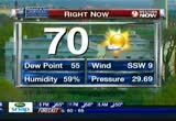
most of the showers and thunderstorms pushing through eastern kentucky, so they're through louisvillen sections of indiana. look in their wake what was left. these are tornado reports. they're unconfirmed. maybe they're doubled up, but still look at all the severe weather. we have hail reported in most of the storms, tornadoes, flooding, hail down south, another tornado just north of port smith and another tornado just off winchester in ohio. so a tremendous severe weather outbreak. good news for us. we are looking at the activity pushing east. we'll have a break the next several hours, nothing heavy getting into the evening hours, but we're not done yet because the frontal system itself is still out to the west. in the meantime we're actually in pretty good shape over the course of the next few hours. that said the watch has been expanded for the entire metro area except maybe for southern maryland under the flood watch through tomorrow morning. so right now we're looking at a little bit of light rain, temperatures generally in the upper 40s, haven't moved much, pressure falling 29.8
most of the showers and thunderstorms pushing through eastern kentucky, so they're through louisvillen sections of indiana. look in their wake what was left. these are tornado reports. they're unconfirmed. maybe they're doubled up, but still look at all the severe weather. we have hail reported in most of the storms, tornadoes, flooding, hail down south, another tornado just north of port smith and another tornado just off winchester in ohio. so a tremendous severe weather outbreak. good news...
462
462
Mar 4, 2012
03/12
by
WUSA
tv
eye 462
favorite 0
quote 0
. >> it headed into eastern kentucky cutting a path of destruction 52 miles long. >> reporter: the national weather service is saying it's an f 4. >> it's in the violent category that most tornadoes never come anywhere near to. >> reporter: one young survivor is recovering in louisville. rescuers found the 2-year-old in a field near her home. in ohio a twister tore up the town of moscow killing two people and a few people died in alabama. back in henryville, long time resident wayne jones is trying to stay positive. >> i have insurance that covers everything, just pay everything off and start over. >> reporter: jones will have to start by finding a new place to live, susan mcginnis, cbs news, henryville, indiana. >> tonight emergency cows are afraid the death tom is going to rise -- toll is going to rise. >>> small kentucky town in morgan county lab demolished in the storm. tonight residents are going through what's left of their homes and possessions through the area. in homessen -- many homes have been destroyed. >> can't get in to put a roof on. probably all the gone by the time -- be go
. >> it headed into eastern kentucky cutting a path of destruction 52 miles long. >> reporter: the national weather service is saying it's an f 4. >> it's in the violent category that most tornadoes never come anywhere near to. >> reporter: one young survivor is recovering in louisville. rescuers found the 2-year-old in a field near her home. in ohio a twister tore up the town of moscow killing two people and a few people died in alabama. back in henryville, long time...
187
187
tv
eye 187
favorite 0
quote 0
and in eastern kentucky, for example, west liberty where you saw jim, that was a powerful tornado thated through. they'll see occasional snow showers. light rain moving into southern illinois. if you remember, harrisburg tornado, that caused so much devastation there, so some wet weather coming in those areas as well and indiana, they're doing okay at this time in terms of active weather but you can see that moisture heading their way, looking for a little rain, changing over to snow tonight. winter weather advisories have been issued in some of the areas. accumulations will be around one to three inches. even for people who didn't have so much damage to their homes, a lot of folks still don't have power. and that's a great concern when you're talking about snow moving in and temperatures which are going to be dropping be lo the freezing mark. for tonight here's the clipper. you can see it's moving through very quickly and by tomorrow it's going to be out of there and they're going to be looking for improving conditions. your current temperatures right now into the 40s and 50s across t
and in eastern kentucky, for example, west liberty where you saw jim, that was a powerful tornado thated through. they'll see occasional snow showers. light rain moving into southern illinois. if you remember, harrisburg tornado, that caused so much devastation there, so some wet weather coming in those areas as well and indiana, they're doing okay at this time in terms of active weather but you can see that moisture heading their way, looking for a little rain, changing over to snow tonight....
142
142
Mar 4, 2012
03/12
by
KBCW
tv
eye 142
favorite 0
quote 0
. >> the tornado that tore through henryville headed across the state line into eastern kentucky. cutting a path of destruction 52 miles long. >> the national weather service is classifying it as f4. >> it's in that violent category that most tornadoes don't come anywhere near. >> rescuers in salem, indiana, found the two-year-old in a field near her home. in ohio, a twister tore up the town of moscow, killing several people. and at least one person died in alabama where the first storms started friday morning. back in henryville, long time resident, wayne jones, is trying to stay positive. >> i have insurance that covers everything. i'll just pay everything off and start over. >> jones will have to start with finding a new place to live. susan, cbs news, henryville, indiana. >> the death toll is expected to rise as officials search for those still missing. president obama called the governor's of indiana, kentucky, and ohio to promise federal assistance in their recovery. >>> united airlines new computer system hit some turbulence today. the final step in the merger of continenta
. >> the tornado that tore through henryville headed across the state line into eastern kentucky. cutting a path of destruction 52 miles long. >> the national weather service is classifying it as f4. >> it's in that violent category that most tornadoes don't come anywhere near. >> rescuers in salem, indiana, found the two-year-old in a field near her home. in ohio, a twister tore up the town of moscow, killing several people. and at least one person died in alabama where...
115
115
Mar 1, 2012
03/12
by
CSPAN3
tv
eye 115
favorite 0
quote 0
in particular, coal, so important to my region of southern and eastern kentucky and our country's most abundant energy resource has remained squarely in the administration's cross hairs. although your budget tries to hide it, your proposal significantly rolls back investment and carbon captured, carbon storage and the advanced energy systems programs that would allow our country to more efficiently use the fossil fuels already at our disposal. instead, these funds have been shuffled around to support the president's pet projects including a proposed $500 million increase for the energy efficiency and renewable energy program. which is already funded at $1.8 billion. as the epa rolls out the regulations and flushes out a proposed green house gas rule, these fossil rnd funds are vital to developing the new technologies necessary to comply with the administration's own control standards. essentially, the administration has created a catch 22. demanding that industry invest heavily into new technology in order to meet stricter standards while cutting off the funding for those investments.
in particular, coal, so important to my region of southern and eastern kentucky and our country's most abundant energy resource has remained squarely in the administration's cross hairs. although your budget tries to hide it, your proposal significantly rolls back investment and carbon captured, carbon storage and the advanced energy systems programs that would allow our country to more efficiently use the fossil fuels already at our disposal. instead, these funds have been shuffled around to...
286
286
Mar 24, 2012
03/12
by
WBAL
tv
eye 286
favorite 0
quote 0
then west of that, out in ohio and eastern kentucky, another line of showers. that won't be all of it. we have a bit of a haze. nothing is ads extensive. our temperatures are mild. 90% the humidity. it hit 81 at the airport. 81 at the inner harbor. it was a great day yesterday. 56 was the normal high. the record was 82, 1907. we did not tie it, but we were close. just to remind you, 16 was the record low on this date in 1934. so that's the other end of the scale. so we're doing fine. warmer out west of the potomac river. here's the center of the storm. although it will be tougher to warm up during the day today. the rain chance stays with us through the weekend. east winds with a one-foot chop on the open waters of the bay. that's the bay forecast. the rain chances, as i mentioned, the highest chance for thunderstorm activity is today. rain chances stick with us into sunday. the coolest day will be tuesday with a high of 58. that's still just above arge for the season. we have another rain chance on wednesday. >> well, it will be an expensive fix for the oldest
then west of that, out in ohio and eastern kentucky, another line of showers. that won't be all of it. we have a bit of a haze. nothing is ads extensive. our temperatures are mild. 90% the humidity. it hit 81 at the airport. 81 at the inner harbor. it was a great day yesterday. 56 was the normal high. the record was 82, 1907. we did not tie it, but we were close. just to remind you, 16 was the record low on this date in 1934. so that's the other end of the scale. so we're doing fine. warmer out...
259
259
Mar 4, 2012
03/12
by
KTVU
tv
eye 259
favorite 0
quote 0
. >>> the hardest hit regions appear to be southern indiana and eastern kentucky and these pictures tell the story. this is a tornado that hit henryville, indiana yesterday. the storm killed at least one person and severely daniel damaged that city. >> one of the hardest hit communities is marysville, indiana, across the ohio refer from louisville, kentucky. reporter craig boswell is there with how people are lending a hand. >> reporter: ken, good evening to you. there is a path of destruction that stretches for miles across the hoosier state, 14 confirmed dead. in the tiny town of marysville, indiana, tornado survivors are shell-shocked. >> it's just unbelievable. the naked eye can't hardly see all the damage it really did do here. the whole place wiped out like that. >> reporter: the national weather service says the ef-4 tornado shredded this place and move on. it's back-breaking work sorting through the rubble, but stories are emerging, tales of the generosity of complete strangers. >> i had a guy pull in this morning and said you want us to take that tree off your house. we'll do fo
. >>> the hardest hit regions appear to be southern indiana and eastern kentucky and these pictures tell the story. this is a tornado that hit henryville, indiana yesterday. the storm killed at least one person and severely daniel damaged that city. >> one of the hardest hit communities is marysville, indiana, across the ohio refer from louisville, kentucky. reporter craig boswell is there with how people are lending a hand. >> reporter: ken, good evening to you. there is a...
212
212
Mar 14, 2012
03/12
by
WJLA
tv
eye 212
favorite 0
quote 0
eastern kentucky earlier had a comeback of their own to beat mississippi valley state. cking kentucky, ohio state missouri, and north carolina to be in the final four. on the women's side, he selected baylor, st. john's, connecticut, and notre dame. republican rival mitt romney says he's not going to fill out a bracket this year. >> the president picking some safe bets. you cannot go wrong with the tar heels, ky. there's more to come in the next hour. >> we have breaking news from japan. there's just been another earthquake. >> breaking news, afghanistan. there's another been another attack whatcha lookin' for hon? ah, these new jeans i want. i've been looking everywhere. new blue jeans? oh don't be crazy i've got tons of blue jeans. frank! frank! get my jean bin, susie wants my jeans. no she doe't. here we go. nice and loose. ohhh. those are loose, but i actually just ordered three pairs of this kind. ooooohhhh. oh. when it's on your mind, it's on ebay. >> straight ahead at 6:00, the manhunt for a murder suspect in montgomery county ended in gunfire. >> and we are follo
eastern kentucky earlier had a comeback of their own to beat mississippi valley state. cking kentucky, ohio state missouri, and north carolina to be in the final four. on the women's side, he selected baylor, st. john's, connecticut, and notre dame. republican rival mitt romney says he's not going to fill out a bracket this year. >> the president picking some safe bets. you cannot go wrong with the tar heels, ky. there's more to come in the next hour. >> we have breaking news from...
370
370
tv
eye 370
favorite 0
quote 0
construction and dedication across the midwest south latest on tornadoes across southern indiana eastern kentucky and ohio storm claimed at least 18 deaths and 13 indiana with five and kentucky numbers climbing during this hour many people some still trapped in the rubble. tomorrow morning updating you terrible that the amat terrible history any guide have not heard the final tally from this i remember back in the outbreak super outbreak 1974148 tornadoes across all kinds of states days before we realized what the toll was on that terrible >> something like this every couple of decades. snowfall on the backside of the storm with numbers. system with the last one to 5 in. of snowfall in the kendry county community. the island lake had 1 in.. you can see it's no fault in retreat coming down parts of eastern northeast wisconsin. no. or michigan and eastern uc thunderstorms across eastern united states. visibility snow intensity waukegan 3 mi. as ability. snowfall totals work in progress snowfall eastern wisconsin. milwaukee 4.5 in.. advisories continue tornadoes in the deep south advisories for wint
construction and dedication across the midwest south latest on tornadoes across southern indiana eastern kentucky and ohio storm claimed at least 18 deaths and 13 indiana with five and kentucky numbers climbing during this hour many people some still trapped in the rubble. tomorrow morning updating you terrible that the amat terrible history any guide have not heard the final tally from this i remember back in the outbreak super outbreak 1974148 tornadoes across all kinds of states days before...
254
254
Mar 4, 2012
03/12
by
CNNW
tv
eye 254
favorite 0
quote 0
we could see a couple of inches say in eastern parts of kentucky.liberty, where jim was, could get as much as 1 to 3 inches. that's something we'll be watching very closely. and temperatures tonight dropping down below freezing, so even though some people are in their homes, there are people that can live in their homes that don't have power, fredricka. that's the concern that folks are going to be real cold tonight in dealing with this wet weather. >> pretty miserable stuff. thanks so much. appreciate that. >>> michele bachmann may no longer be in the thick of the presidential race, but she isn't out, completely. she does have some strong opinions still. coming up, what she says her role is now, her thoughts on rush limbaugh's controversial comments to a coed and what about an endorsement? and prince harry hits the road. it is his first test as royal ambassador. i want to fix up old houses. ♪ [ woman ] when i grow up, i want to take him on his first flight. i want to run a marathon. i'm going to own my own restaurant. when i grow up, i'm going to s
we could see a couple of inches say in eastern parts of kentucky.liberty, where jim was, could get as much as 1 to 3 inches. that's something we'll be watching very closely. and temperatures tonight dropping down below freezing, so even though some people are in their homes, there are people that can live in their homes that don't have power, fredricka. that's the concern that folks are going to be real cold tonight in dealing with this wet weather. >> pretty miserable stuff. thanks so...
141
141
Mar 2, 2012
03/12
by
WTTG
tv
eye 141
favorite 0
quote 0
here's the rain off to the south and west and already thunderstorm activity this morning into eastern kentucky and eastern tennessee. that whole area of rain shower activity is kind of lifting up into the mid-atlantic here by late afternoon and during the evening hours. i think 3:00, 4:00 today we'll get some showers in here and they'll be with us through the evening hours right into the first mart of the weekend into tomorrow morning. futurecast doing a nice job and here come the clouds at 9:00 a.m. just a little few clouds but by 4:00, 5:00 today some showers and by 6:00, futurecast indicating widespread showers maybe even a thunderstorm out there late this afternoon. and then tonight, we're going to have some showers off and on again here for the overnight hours. then tomorrow morning with a cold front. we've got the possibility of another round of as long as and then we'll quiet down. so much to have day tomorrow will be dry but to be honest with you think i we're going to start off are rain showers and some clouds and then by mid to late afternoon some clearing north and west and some lat
here's the rain off to the south and west and already thunderstorm activity this morning into eastern kentucky and eastern tennessee. that whole area of rain shower activity is kind of lifting up into the mid-atlantic here by late afternoon and during the evening hours. i think 3:00, 4:00 today we'll get some showers in here and they'll be with us through the evening hours right into the first mart of the weekend into tomorrow morning. futurecast doing a nice job and here come the clouds at...
314
314
Mar 3, 2012
03/12
by
CNNW
tv
eye 314
favorite 0
quote 0
we also have incredible new video out of a tornado on the eastern section here of kentucky. kind of the coal fields of kentucky. west liberty, kentucky. this was by far in my opinion, watching the doppler radar, the strongest tornado on radar. doesn't mean it was the strongest one on the ground, but the rotation was the strongest and tightest, speeds going one way to another way were at least 100 miles per hour. this on radar looks like an ef-3 or ef-4 tornado. now with the first video out, driving into west liberty, you can see the damage. yes, it's dark, but you can get a feel for the buildings knocked down. really, a police car that was damaged completely. and more tornado damage from cars being just -- things tossed onto them. people are out there, search and rescue. the national guard has been called out. 50 members going out to help in the clean up and rescue tonight. it's been a deadly day across the country today. we don't know the number of casualties, but we know more than a dozen so far confirmed by cnn, and now that it's dark, people still missing, these numbers
we also have incredible new video out of a tornado on the eastern section here of kentucky. kind of the coal fields of kentucky. west liberty, kentucky. this was by far in my opinion, watching the doppler radar, the strongest tornado on radar. doesn't mean it was the strongest one on the ground, but the rotation was the strongest and tightest, speeds going one way to another way were at least 100 miles per hour. this on radar looks like an ef-3 or ef-4 tornado. now with the first video out,...
636
636
Mar 3, 2012
03/12
by
KNTV
tv
eye 636
favorite 0
quote 0
>> some is rolling across eastern parts of kentucky. we have tornado warnings all the way north of the ohio river down to the gulf coast. take a look at the satellite picture. the orange are high-top thunderstorms down from pennsylvania to eastern tennessee into louisiana. isolated storms ahead of that across parts of the rest of the gulf coast states. all this being fed by a huge strong jet stream and rotating pocket aloft and warm, moist air at low levels. in red, all of these red online areas are tornado warnings for individual storms from west virginia to east kentucky, southwest virginia, tennessee down into parts of alabama, mississippi, and that is likely to continue. we have forecasted still some of our greatest threat areas, we only do that a few times per year with a tor:con of 9. in eastern parts of kentucky and in the red shaded area, severe weather to pittsburgh and charlotte, down into the gulf coast states. it is still a very active, very dangerous etching tonight. >> dr. greg forbes who has been following all of it, his
>> some is rolling across eastern parts of kentucky. we have tornado warnings all the way north of the ohio river down to the gulf coast. take a look at the satellite picture. the orange are high-top thunderstorms down from pennsylvania to eastern tennessee into louisiana. isolated storms ahead of that across parts of the rest of the gulf coast states. all this being fed by a huge strong jet stream and rotating pocket aloft and warm, moist air at low levels. in red, all of these red...
238
238
Mar 2, 2012
03/12
by
MSNBCW
tv
eye 238
favorite 0
quote 0
eastern portions of kentucky. as we move southwards. nashville, just about in the clear. u saw large hail. the tornado threat is now more or less to the eastern side of town. we'll watch out for knoxville throughout the evening and also a very strong storm over the top of chattanooga. as far as the forecast goes, we're watching to the south, the worst of the weather throughout the evening. eventually those storms will make their way to atlanta, northern portions of alabama and into the carolinas overnight. the bottom line is we have fatalities. most of the worst damage appears to have been including areas of southern indiana. al, we have about two different towns. one town of 3,000 people, another of 1500 people that are practically wiped off the map. and that's where all the focus and attention will be needed tonight and tomorrow. >> well, thanks, bill. we'll continue to monitor this developing story. >>> we'll be right back. becauset with food. switch to citracal maximum plus d. it's the only calcium supplement that can be taken with or without food. that's why my doctor
eastern portions of kentucky. as we move southwards. nashville, just about in the clear. u saw large hail. the tornado threat is now more or less to the eastern side of town. we'll watch out for knoxville throughout the evening and also a very strong storm over the top of chattanooga. as far as the forecast goes, we're watching to the south, the worst of the weather throughout the evening. eventually those storms will make their way to atlanta, northern portions of alabama and into the...
209
209
tv
eye 209
favorite 0
quote 0
southern indiana and southern parts of ohio into eastern kentucky and west virginia.e are the places that will see the rain changing and accumulating and stick around through tomorrow morning. high pressure builds in and clears things out. the other concern is that the temperatures are going to be cold behind it. freezing conditions overnight and there is a lot of people whose homes are fine. you can see the big picture tomorrow and a big storm in the pacific northwest. the top five cities, the cities you don't want to be included in. city number five, atlanta, georgia with blustery conditions expected. weather-wise, it's fine outside of the wind, but keep that in mind. city number four, dallas, texas, gusts up to 25 miles per hour so that can cause issues at the airports. city number three, baltimore, maryland looking for light rain and snow, but low clouds could cause problems at bwi. city number two, washington, d.c. with the rain and snow and city number one, we have a tower cam to show you from what's the city? >> the space needle. >> stealths. >> can we let peop
southern indiana and southern parts of ohio into eastern kentucky and west virginia.e are the places that will see the rain changing and accumulating and stick around through tomorrow morning. high pressure builds in and clears things out. the other concern is that the temperatures are going to be cold behind it. freezing conditions overnight and there is a lot of people whose homes are fine. you can see the big picture tomorrow and a big storm in the pacific northwest. the top five cities, the...
73
73
tv
eye 73
favorite 0
quote 0
we also have incredible new video out of a tornado on the eastern section here of kentucky. kind of the coal fields of kentucky. west liberty, kentucky. this was by far in my opinion, watching the doppler radar, the strongest tornado on radar. doesn't mean it was the strongest one on the ground, but the rotation was the strongest and tightest, speeds going one way to another way were at least 100 miles per hour. this on radar looks like an ef-3 or ef-4 tornado. now with the first video out, driving into west liberty, you can see the damage. yes, it's dark, but you can get a feel for the buildings knocked down. really, a police car that was damaged completely. and more tornado damage from cars being just -- things tossed onto them. people are out there, search and rescue. the national guard has been called out. 50 members going out to help in the clean up and rescue tonight. it's been a deadly day across the country today. we don't know the number of casualties, but we know more than a dozen so far confirmed by cnn, and now that it's dark, people still missing, these numbers
we also have incredible new video out of a tornado on the eastern section here of kentucky. kind of the coal fields of kentucky. west liberty, kentucky. this was by far in my opinion, watching the doppler radar, the strongest tornado on radar. doesn't mean it was the strongest one on the ground, but the rotation was the strongest and tightest, speeds going one way to another way were at least 100 miles per hour. this on radar looks like an ef-3 or ef-4 tornado. now with the first video out,...
136
136
Mar 1, 2012
03/12
by
WTTG
tv
eye 136
favorite 0
quote 0
see the clear skies west virginia and eastern kentucky. >>> forecast today, lots of sunshine, breezy high temperatures mid- to upper 60s. a few 70s maybe a 70 afternoon high fredericksburg more details on the forecast and a look at the weekend in a few minutes tony. >> thanks very much. >>> our big story this morning in just a few hours gay marriage will become legal in maryland making it the 8th state to legalize same-sex marriage. >> don't expect wedding licenses to be handed out or ceremonies performed just yet, governor o'malley is expected to sign the same-sex marriage bill this afternoon however the law will not go into effect until next january, that is because opponents of the bill are still trying to stop it from happening they promise to get the more than 55,000 signatures needed to put the matter on november's ballot for maryland voters. >>> the senate is set to take a vote today on lean sleigh aimed at rolling back president -- legislation aimed at rolling back president obama's birth control policy allowing employers and insurers to opt out of anything they reject on mor
see the clear skies west virginia and eastern kentucky. >>> forecast today, lots of sunshine, breezy high temperatures mid- to upper 60s. a few 70s maybe a 70 afternoon high fredericksburg more details on the forecast and a look at the weekend in a few minutes tony. >> thanks very much. >>> our big story this morning in just a few hours gay marriage will become legal in maryland making it the 8th state to legalize same-sex marriage. >> don't expect wedding licenses...
219
219
tv
eye 219
favorite 0
quote 0
for tornadoes in eastern kentucky friday, another five posters touched down in ohio. >> and those who live in the area prone for tornadoes are hoping that the deadly start doesn't trigger the kind of twisters from last year. tornadoes killed more than 500 people across the u.s. in 2011 making it the deadliest year in almost a century. >>> back here a community is coming together to remember a five-year-old girl who was beaten to death last week. police say her father is responsible. wishing has the story. >> good morning, everyone. there was almost as many children as adults at the vigil. even the youngest person we spoke with knew what police say was the motive, but nobody can make sense of it. >> after losing her five-year- old daughter, she was inconsolable. on saturday night, loved ones gathered at the baltimore city school to remember the little girl. >> it's really painful. i could go home and punch a pillow. >> the sadness next with anger over how she was killed. police say her father became so angry after she soiled herself that he confessed to beating his child repeatedly wit
for tornadoes in eastern kentucky friday, another five posters touched down in ohio. >> and those who live in the area prone for tornadoes are hoping that the deadly start doesn't trigger the kind of twisters from last year. tornadoes killed more than 500 people across the u.s. in 2011 making it the deadliest year in almost a century. >>> back here a community is coming together to remember a five-year-old girl who was beaten to death last week. police say her father is...
216
216
Mar 23, 2012
03/12
by
WTTG
tv
eye 216
favorite 0
quote 0
frontal system out there in ohio and eastern kentucky. you can see the rain showers and the clouds.o work in later today and tonight. cloud up during the evening hours. i think the rain will start to arrive by sunrise tomorrow. not going to rain all day tomorrow. we'll have periods of rain. warm front north of us now. temperatures are going to be a little warmer than yesterday. should be in the 80s later this afternoon. with the cold front to the west moving through, we'll have rain showers, perhaps a thunderstorm both saturday and sunday. behind it, cooler temperatures with highs in the 60s. let's do the five-day forecast. absolutely perfect today. 82degrees, lots of sunshine. then we cloud up with rain showers both saturday and sunday. then the cooler temperatures, highs by next tuesday, only about 62 degrees. might have to bring out the jacket you put away for the winter. that's a look at your forecast. sarah, back to you inside the comfy fox 5 studios. >> tucker, thank you. >>> some could consider our next guest as hip hog royalty, but diggy simmons has always wanted to do this
frontal system out there in ohio and eastern kentucky. you can see the rain showers and the clouds.o work in later today and tonight. cloud up during the evening hours. i think the rain will start to arrive by sunrise tomorrow. not going to rain all day tomorrow. we'll have periods of rain. warm front north of us now. temperatures are going to be a little warmer than yesterday. should be in the 80s later this afternoon. with the cold front to the west moving through, we'll have rain showers,...
118
118
tv
eye 118
favorite 0
quote 0
eastern kentucky is rugged terrain. you've got hills and valleys and mountains.nd that's another thing. one thing they're up against, four inches of snow making things colder and more dangerous. >> challenge after challenge. rob marciano, we're thinking of all those folks there impacted in indiana and kentucky. >>> meantime, we're now less than 24 hours until super tuesday. and why is this race so important when it comes to the race to the white house? and why should so much emphasis be placed on ohio? that's next. asy it is to use legalzoom for important legal documents. at legalzoom we'll help you incorporate your business, file a patent, make a will and more. you can complete our online questions in minutes. then we'll prepare your legal documents and deliver them directly to you. so start your business, protect your family, launch your dreams. at legalzoom.com, we put the law on your side. borrowed technology from ferrari to develop its suspension system? or what if we told you that ferrari borrowed technology from cadillac to develop its suspension system? m
eastern kentucky is rugged terrain. you've got hills and valleys and mountains.nd that's another thing. one thing they're up against, four inches of snow making things colder and more dangerous. >> challenge after challenge. rob marciano, we're thinking of all those folks there impacted in indiana and kentucky. >>> meantime, we're now less than 24 hours until super tuesday. and why is this race so important when it comes to the race to the white house? and why should so much...
185
185
Mar 4, 2012
03/12
by
KBCW
tv
eye 185
favorite 0
quote 0
four tornadoes in eastern kentucky friday, another five twisters touched down in southwest ohio. very unseasonably warm air that triggered this in southern indiana was back on friday, so, we have tornadoes that caused damage like this. then come today, this morning, you won't believe it, phil and ann, a wintery mix in the forecast! so, folks out here bundled up as they continue the search and rescue efforts. >> there is a lot of work that needs to be done to clean up these areas. what about rescue teams coming from other parts of the country? are they starting to dribble in? what do we expect as far as aid from the red cross and feds? >> reporter: we have the red cross here and the national guard. during the live shot i was trying not to get hit by a power truck backing up. this is what is happening right now. power coming back amazingly fast. it is in our hotels and the outskirts of the devastated area power is back. it is this kind of work, folks filing in from all across the region making this happen. an incredible endeavor to watch so quickly after the storms hit. >> terrell
four tornadoes in eastern kentucky friday, another five twisters touched down in southwest ohio. very unseasonably warm air that triggered this in southern indiana was back on friday, so, we have tornadoes that caused damage like this. then come today, this morning, you won't believe it, phil and ann, a wintery mix in the forecast! so, folks out here bundled up as they continue the search and rescue efforts. >> there is a lot of work that needs to be done to clean up these areas. what...
159
159
Mar 30, 2012
03/12
by
WUSA
tv
eye 159
favorite 0
quote 0
thunderstorms pushing into western maryland, but by and large, the heaviest activity is down into eastern kentuckyto ohio. so we don't have to really worry about anything in the immediate metro area in terms of the thunderstorm until tomorrow morning. if we don't get a thunderstorm tomorrow morning, we're pretty much in the clear by afternoon, maybe a shower saturday afternoon but not that big of deal. temperatures, still 49 in rockville, 48 gaithersburg, kind of a reminder we are indeed in the month of march. arlington 51, 56 springfield, 50 college park. some areas climbed a little with this bit of sun in the evening. more bark than bite with these clouds. cloudy tonight, maybe a shower, mostly cloudy tomorrow morning, a shower or thunderstorm possible, but i think you can play golf or get your yard work done and some sunshine will return late tomorrow afternoon. so again not a perfect weekend but doable. futurecast, 7:45 a.m., breaks in the cloud right around town with showers in the mountains, kind of a hit or miss deal in the morning, some showers by and large west of i-81, certainly a better
thunderstorms pushing into western maryland, but by and large, the heaviest activity is down into eastern kentuckyto ohio. so we don't have to really worry about anything in the immediate metro area in terms of the thunderstorm until tomorrow morning. if we don't get a thunderstorm tomorrow morning, we're pretty much in the clear by afternoon, maybe a shower saturday afternoon but not that big of deal. temperatures, still 49 in rockville, 48 gaithersburg, kind of a reminder we are indeed in the...
146
146
Mar 23, 2012
03/12
by
WJZ
tv
eye 146
favorite 0
quote 0
eastern. and kentucky versus indiana at 9:45. those games right here on cbs.est, north carolina takes on ohio at 7:47. and kansas plays north carolina state at 10:17 on tbs. >>> when we return, terror for a tv news crew. a man gets angry and pulls a gun on a reporter in arkansas. we'll show you what happens next. [ female announcer ] with xfinity, you can always expect more. like more on demand shows and movies than ever. and more ways to discover them too. plus more speed from america's fastest internet provider. so you can run more devices at the same time. ♪ feel a firework [ female announcer ] and best of all, it keeps getting better. no wonder more people choose xfinity over any other provider. ♪ love can be so mystical ♪ it's irresistible. experience this in your home with resolve deep clean powder. its moist powder penetrates deep, removing three times more dirt than vacuuming alone while also neutralizing odors at their source. it's a clean you can see, smell, and really enjoy. resolve deep clean powder. don't just vacuum clean, resolve clean. >>> here
eastern. and kentucky versus indiana at 9:45. those games right here on cbs.est, north carolina takes on ohio at 7:47. and kansas plays north carolina state at 10:17 on tbs. >>> when we return, terror for a tv news crew. a man gets angry and pulls a gun on a reporter in arkansas. we'll show you what happens next. [ female announcer ] with xfinity, you can always expect more. like more on demand shows and movies than ever. and more ways to discover them too. plus more speed from...
132
132
Mar 3, 2012
03/12
by
FOXNEWS
tv
eye 132
favorite 0
quote 0
now they are pulling up toward the eastern part of kentucky. i think probably, bret the next three hours we still have a threat for large long live dangerous tornadoes. at that point, we'll have a tornado threat to the overnight hours and we will see smaller tornadoes. that doesn't mean it can't damage your place or cause significant problems but the next few hours i think are dangerous. kentucky and tennessee parts of ohio are likely the worse of this. >> bret: especially in the tarkness. we have new video in from indiana. some of the towns there that are hit. this is amateur video looking at this tornado. some of the storm chaser videos. listen, when there is a warning, it means that someone has seen the tornado or there is authorities that are saying it's on the ground. people should act. >> also possibly that the radar indicating an enough rotation they believe there is a tornado on the ground. these today, all of the radar signatures have been verifying that there is a tornado on the ground. one of the problems has been they are either rap
now they are pulling up toward the eastern part of kentucky. i think probably, bret the next three hours we still have a threat for large long live dangerous tornadoes. at that point, we'll have a tornado threat to the overnight hours and we will see smaller tornadoes. that doesn't mean it can't damage your place or cause significant problems but the next few hours i think are dangerous. kentucky and tennessee parts of ohio are likely the worse of this. >> bret: especially in the...
 Live Music Archive
 Librivox Free Audio
 Metropolitan Museum
 Cleveland Museum of Art
 Internet Arcade
 Console Living Room
 Open Library
 American Libraries
 TV News
 Understanding 9/11