185
185
Jul 2, 2011
07/11
by
WBAL
tv
eye 185
favorite 0
quote 0
towards hagerstown, there is some schar activity. in the turnpike here, at this spot of red is a thunderstorm cell and it is moving to the south right now. hagar's time -- hagerstown should pick up some rain. something is beginning to pick up as this system gets closer to was. temperatures are another part of the formula. the high temperature was around 90-95. still in the 90's where you see the red along the eastern shore and west of us like gaithersburg, frederick. everyone else is in the mid to upper 80's. in the 70's in the mountains to the west. but this evening, a cold front is approaching. the high pressure that give this a great few days here with comfortable conditions is sliding out of the picture. the cold front is approaching and the chances for rain increase. this will take place during part of this weekend, not the entire weekend. looking at the general map, there's not a lot of rain to the west associated with the front of the great lakes. a lot of the moisture is being cut off, but some heat and humidity is coming int
towards hagerstown, there is some schar activity. in the turnpike here, at this spot of red is a thunderstorm cell and it is moving to the south right now. hagar's time -- hagerstown should pick up some rain. something is beginning to pick up as this system gets closer to was. temperatures are another part of the formula. the high temperature was around 90-95. still in the 90's where you see the red along the eastern shore and west of us like gaithersburg, frederick. everyone else is in the mid...
49
49
quote
eye 49
favorite 0
quote 1
61-degrees in hagerstown and 59 in elkton and 63 in easton and ocean city. almost 70 in d.c. and 71 annapolis and kent island. greater columbia at 60. 62 bel air and easton at 68 degrees. high pressure out of the great lakes and that gives us a beautiful day yesterday. the air's about that much closer though. the high pressure slips down to the south. that becomes the bermuda high. the big heat pump sets up and it will be steamy and hot. again, the 4th of july is supposed to feel this way. 89 is the high and 62 is the low. 92 tomorrow and more humid. same deal on saturday. that's tomorrow, 92, same deal on sunday. watch for a popup afternoon thunderstorm. monday, july 4th, monday, 92 is the high. 88 and 90. i mentioned this last half hour. it's worth mentioning again as
61-degrees in hagerstown and 59 in elkton and 63 in easton and ocean city. almost 70 in d.c. and 71 annapolis and kent island. greater columbia at 60. 62 bel air and easton at 68 degrees. high pressure out of the great lakes and that gives us a beautiful day yesterday. the air's about that much closer though. the high pressure slips down to the south. that becomes the bermuda high. the big heat pump sets up and it will be steamy and hot. again, the 4th of july is supposed to feel this way. 89...
248
248
Jul 5, 2011
07/11
by
WTTG
tv
eye 248
favorite 0
quote 0
win chest are, hagerstown, you are dealing with fog and reduced visibilities up there. temperature, 75. 75 at reagan national. 64 in winchester. not too bad north and west. same can't be said for the east. more sunshine than yesterday and the heat will be right back in the same department, upper 80s and low 90s. and we took the opportunity or the possibility of a shower or thunderstorm out of the forecast for the day. so today should be dry although. possibility of thunderstorms return tomorrow. i'll have details on that coming up in just a minute. >> thank you. >>> let's check in with talker and get a look at traffic. good morning, guys. >> tell me about your fourth of july. i heard yesterday that you had some sort of surprise location that you were going to or secret location i can't it was a secret barbecue. >> at the whitehouse or something? >> well, we're in the going to talk about that. i can't talk about that one. i can talk about the one that was at my house. >> you had two barbecues. >> the other one was secret so i can't talk about it. we'll talk about that of
win chest are, hagerstown, you are dealing with fog and reduced visibilities up there. temperature, 75. 75 at reagan national. 64 in winchester. not too bad north and west. same can't be said for the east. more sunshine than yesterday and the heat will be right back in the same department, upper 80s and low 90s. and we took the opportunity or the possibility of a shower or thunderstorm out of the forecast for the day. so today should be dry although. possibility of thunderstorms return...
224
224
Jul 8, 2011
07/11
by
WTTG
tv
eye 224
favorite 0
quote 0
let's see, we've got 160 on the map. 69 in hagerstown and 70 in hagerstown. showers and thunderstorms developing, better chance this afternoon than this morning. some with heavy rain and again we have a flash flood watch in effect. sarah, back to you. >>> taking a look at the top stories this morning, a lot of action on the vw parkway in maryland this morning. this is a live look we are taking right now. first, both directions of the parkway are closed at kennel worth avenue because of a carjacking it actually started in anne arundel county. meanwhile, also following a deadly accident that closed northbound lanes of the parkway in laurel all night. it remains shutdown this morning. a car carrying four people you? crashed and ended -- somehow ended and ended up in the woods. >>> meantime, casey anthony will now be released from a florida jail a week from sunday. that's different from the date announced yesterday by the florida corrections department. authorities recalculated the time and after the judge sentenced her to four years for lying to investigators, s
let's see, we've got 160 on the map. 69 in hagerstown and 70 in hagerstown. showers and thunderstorms developing, better chance this afternoon than this morning. some with heavy rain and again we have a flash flood watch in effect. sarah, back to you. >>> taking a look at the top stories this morning, a lot of action on the vw parkway in maryland this morning. this is a live look we are taking right now. first, both directions of the parkway are closed at kennel worth avenue because of...
220
220
tv
eye 220
favorite 0
quote 0
temperatures to the north, 82 in hagerstown, 84 in frederick.hat's because of a little boundary that's moved through and some shower activity, as well. take a look at these storms right around frederick, maryland, just off to the east, right along i-70. more storms towards martinsburg and west virginia. we'll zoom into just west of mt. erie, that storm moving into your region. and the other storm toward the west in towards around the bettington area and also just to the south and we feel of williams port along 81, that storm making its way from morgan county into berkeley county. we'll continue to watch the storms throughout the evening. more storms likely tomorrow. i'll tell you who i think has the best chance of seeing the rain and when, coming up. jim? >>> thanks, doug. >>> in about three-and-a-half weeks, the united states will reach the debt limit set by congress and the government would not be able to borrow anymore money. opinions vary on what would happen after that. but surely, it would create a situation that would not leave the united
temperatures to the north, 82 in hagerstown, 84 in frederick.hat's because of a little boundary that's moved through and some shower activity, as well. take a look at these storms right around frederick, maryland, just off to the east, right along i-70. more storms towards martinsburg and west virginia. we'll zoom into just west of mt. erie, that storm moving into your region. and the other storm toward the west in towards around the bettington area and also just to the south and we feel of...
199
199
Jul 8, 2011
07/11
by
WUSA
tv
eye 199
favorite 0
quote 0
hagerstown in the upper 70s. cumberland, 73 degrees. clouds limiting how much daytime heating we're going to get. storms are more numerous compared to last night or yesterday. the flash flood watch continues through late tonight. we're expecting heavy severe thunderstorms possible in the area. now, the heaviest, the critical time here is 4:00 p.m. to 9:00 p.m. you'll notice that does include the evening commute. if you have a chance to maybe leave home early and do some work at home, not a bad idea. our main threat, you can see the risk for severe weather is in the areas in yellow including the mid-atlantic and here in d.c. the main threats are damaging wind gusts and the heavy rain. boy, will youst will you notice the rain if you get hit by these storms. where the storms could be going according to this model. late afternoon, 4:00, winchester, martinsburg, frederick, gaithersburg, baltimore, we'll see the showers and thunderstorms really start to act up. and then look at this! at 6:30 tonight, yep. right including the district and look
hagerstown in the upper 70s. cumberland, 73 degrees. clouds limiting how much daytime heating we're going to get. storms are more numerous compared to last night or yesterday. the flash flood watch continues through late tonight. we're expecting heavy severe thunderstorms possible in the area. now, the heaviest, the critical time here is 4:00 p.m. to 9:00 p.m. you'll notice that does include the evening commute. if you have a chance to maybe leave home early and do some work at home, not a bad...
216
216
Jul 8, 2011
07/11
by
WTTG
tv
eye 216
favorite 0
quote 0
hagerstown, strong thunderstorm just to the west, you're going to get wet. winchester another strong thunderstorm kind of to the west and northwest of your vicinity. we can tighten these up a little so you can get a better view. everything is moving off to the east and northeast, very heavy rain here. frederick, virginia, you under a flash flood warning. that's going until 1 a.m. hampshire, virginia, that's going to go until 1:30 a.m. for the flash flood warning. for tomorrow in anticipation of more heavy rain and thunderstorms flash flood watch has already been issued for tomorrow afternoon into tomorrow night. expect the potential maybe as much as 2 to some localized areas 3 inches of rain before this is all said and done early saturday morning. full forecast coming up. >> we do need the rain, thanks. >>> potential jurors from the roger clemens perjury trial facing intense questions today. for a second day the judge and lawyers for both side turned away nearly half of the jury poll, many dismissed after criticizing congress. clemens faces six felony counts
hagerstown, strong thunderstorm just to the west, you're going to get wet. winchester another strong thunderstorm kind of to the west and northwest of your vicinity. we can tighten these up a little so you can get a better view. everything is moving off to the east and northeast, very heavy rain here. frederick, virginia, you under a flash flood warning. that's going until 1 a.m. hampshire, virginia, that's going to go until 1:30 a.m. for the flash flood warning. for tomorrow in anticipation of...
139
139
Jul 5, 2011
07/11
by
WUSA
tv
eye 139
favorite 0
quote 0
even to the north in parts of frederick county back through hagerstown and parts of west virginia. fireworks time. there were a few showers. overnight, the showers have pulled away from us. we're left with clearing skies north and west. still a few clouds south. we've got temperatures running around 70 to 75. we're already down to 62 in martinsburg. 68 in leesburg. it is 6:00 a.m. tuesday. no traffic. due to construction. but maybe other things. >> maybe other things. right now, no big deals because most construction has been delayed to allow people to get back to work easily today. the beltway is looking great. let's zoom into 270. take a live look if you're planning to head in, all the way down toward the beltway in rockville, you'll be fine. this time, zoom into the other side of town to the outer loop and take a live look as well. bit of volume at university boulevard coming around from 95 and college park. you're good to go as you head over to 270 this morning. now, a look at the travel times. if you're planning to head in on 66, 7100 to the beltway, toll road from hunter mill
even to the north in parts of frederick county back through hagerstown and parts of west virginia. fireworks time. there were a few showers. overnight, the showers have pulled away from us. we're left with clearing skies north and west. still a few clouds south. we've got temperatures running around 70 to 75. we're already down to 62 in martinsburg. 68 in leesburg. it is 6:00 a.m. tuesday. no traffic. due to construction. but maybe other things. >> maybe other things. right now, no big...
123
123
Jul 8, 2011
07/11
by
WUSA
tv
eye 123
favorite 0
quote 0
it's a big storm too between hagerstown and martinsburg. this will produce incredible amounts of rain. so you already had heavy rain tonight and don't cross the street by car or by foot if it is flooded. where will these go in the next hour? they're generally going to go off to the north and to the east. and this is going to hold together, the one that is going to go through hagerstown. the rest weaken a little bit as they cross i81. but because they're going to cross i81, some of our western suburbs will have kind of a wet commute tomorrow morning. just a residual moisture. satellite picture, radar combined, we'll go down to the gulf. this could be the next tropical system. not terribly well organized but it's hammering florida with rainfall. that's good. they've had a hard time getting rain on the west side of 75 and earn naples and now they're -- around naples and now they're getting it. the rest of florida has been getting good rain the rest of of the week. we'll move northward. the main focus is going to be this main frontal boundary.
it's a big storm too between hagerstown and martinsburg. this will produce incredible amounts of rain. so you already had heavy rain tonight and don't cross the street by car or by foot if it is flooded. where will these go in the next hour? they're generally going to go off to the north and to the east. and this is going to hold together, the one that is going to go through hagerstown. the rest weaken a little bit as they cross i81. but because they're going to cross i81, some of our western...
172
172
Jul 4, 2011
07/11
by
WMAR
tv
eye 172
favorite 0
quote 0
so that plane was escorted to hagerstown where it landed. authorities questioned the pilot and they determined the entire thing was an accident. >>> in new hampshire republican presidential candidate john hutsman spent the weekend campaigning. he mingled at a house party under the banner of the good old fashioned way. one person at a time. john huntsman is scheduled to hit another house party later today. >>> 4:36. after a day of rest, it's back to the courtroom. >> the casey anthony trial going on today. what to exexpect in the closing arguments and -- what to expect in the closing arguments and when the jury will begin deliberations. >>> it's not too late to make holiday plans. where to go and how to beat the crowd. we have the 411 when we come back. before we head to break at 4:36, we will go live this morning and show you everything going on for holiday celebrations. we will be right back. ÷x# >>> now "good morning maryland" at 4:30. >>> 4:39. a lot of folks had to change their plans sunday evening when the weather forced them to evacuat
so that plane was escorted to hagerstown where it landed. authorities questioned the pilot and they determined the entire thing was an accident. >>> in new hampshire republican presidential candidate john hutsman spent the weekend campaigning. he mingled at a house party under the banner of the good old fashioned way. one person at a time. john huntsman is scheduled to hit another house party later today. >>> 4:36. after a day of rest, it's back to the courtroom. >> the...
307
307
tv
eye 307
favorite 0
quote 0
notice hagerstown, maryland, though, only 81. that's because we have seen some shower activity move through that region, and that's where all of the rain is right now. there is no rain right now around the d.c. not area, but up toward the north, that's where we're seeing rain come in. we'll zoom out here and you can see towards pennsylvania, right along the mason dixon line there, the pennsylvania/maryland border, that's where our rain is. that's where it's going to stay for the next hour or two, and then it will start to move toward the south. how far south? well, we'll have to just wait and see. your good night/wake-up forecast could see showers between 9:00 and 11:00. and tomorrow morning, it says rainy there. let's just go with warm. i think it will be rainier as we make our way through the day tomorrow. a flash flood watch in effect for the day tomorrow. i'll show you who has that and when we could see the most rain. guys? >> thanks, doug. >>> metro riders may notice new shorter station names by next year. the transit agency
notice hagerstown, maryland, though, only 81. that's because we have seen some shower activity move through that region, and that's where all of the rain is right now. there is no rain right now around the d.c. not area, but up toward the north, that's where we're seeing rain come in. we'll zoom out here and you can see towards pennsylvania, right along the mason dixon line there, the pennsylvania/maryland border, that's where our rain is. that's where it's going to stay for the next hour or...
195
195
Jul 3, 2011
07/11
by
WTTG
tv
eye 195
favorite 0
quote 0
pennsylvania and some are creeping into maryland and virginia and i will put winchester to cumberland and hagerstown. they could creep closer to the washington area overnight. i think generally, we will wake up with a mix of sun and clouds. tomorrow afternoon, the cold front, which brought good thunderstorm activities will come keyser and to the showers and thunderstorms around here. a descent chance. 50, 60% chance of some scattered showers and thunderstorms during the afternoon and if you have plans, don't cancel them. be ready for a possibility of some afternoon showers and thunderstorms. the high temperatures tomorrow, 93 in washington; 93, leopardtown; 89, annapolis and in front royal. drier than sunday with highs about 92. tuesday and wednesday, nice and dry with the highs in the low 90s and may be another thunderstorm by the middle and that end of the week. that is the forecast. enjoy the rest of the holiday weekend. will, back to you. >> thank you. >>> we're taking the edge off with some form fun. a lot of phones loaned the streets and this is the start of the full day of holiday activities
pennsylvania and some are creeping into maryland and virginia and i will put winchester to cumberland and hagerstown. they could creep closer to the washington area overnight. i think generally, we will wake up with a mix of sun and clouds. tomorrow afternoon, the cold front, which brought good thunderstorm activities will come keyser and to the showers and thunderstorms around here. a descent chance. 50, 60% chance of some scattered showers and thunderstorms during the afternoon and if you...
243
243
tv
eye 243
favorite 0
quote 1
temperatures will be back into the 90s. 61 hagerstown and elkton and easton.an city at 63 degrees. the low 60s in westminster and bel air. yeah, the heat is going to expand because of the pressure dropping down over the carolina capes becoming the bermuda high. we'll be set up with the warm and humid air. i think for the next four days, not counting this one. it will be a comfortable afternoon. temperatures under clear skies, dropping to 62 tomorrow. we'll kick the temperatures up and add the words to the forecast. the high of 92. the same deal on sunday. watch for the chance of an afternoon thunderstorm on monday. tuesday and wednesday, back into the upper 80s with sun. >>> let's go to sharon gibala with traffic control. >>> hi, don, well, it took a while, but we've picked up the first accident. watch for equipment on the road at wheeler avenue. everything is still at full speed, including on the beltway. there are the average speeds. we can take a live look at frederick road. no issues on 95. there's a look at 50 at the bay bridge. that's if you're heading t
temperatures will be back into the 90s. 61 hagerstown and elkton and easton.an city at 63 degrees. the low 60s in westminster and bel air. yeah, the heat is going to expand because of the pressure dropping down over the carolina capes becoming the bermuda high. we'll be set up with the warm and humid air. i think for the next four days, not counting this one. it will be a comfortable afternoon. temperatures under clear skies, dropping to 62 tomorrow. we'll kick the temperatures up and add the...
256
256
tv
eye 256
favorite 0
quote 0
it's a more comfortable feel. 70 hagerstown and 71 elkton. the district at 77 and 76 pax river. 2 shy of 80, ocean city. and greater columbia, 71 and upper 70s, rock hall and annapolis and kent siled. we have a stalled front. that will allow the moisture to rub along it. that will be north, south and areawide. we'll get a few gusty thunderstorms later on. we'll move into the weekend and next week. today, a high of 85 degrees. frankly, a gray, cool day. some rain and a nice break from the summer feel. tomorrow, back to summer. no complaints saturday with a high of 90, clouds and sun. we'll keep it sunny and in the low 90s, upper 80s. >>> 6:16, any monster jams on the way to work? >> no jams. in fact, we cleared up the accidents we have. we have downed trees left from the overnight storms. two are in the squaresville area -- jarredsville way. one on poplar hill. that's also blocking all lanes. we have fire activity in the area on route 23 and salem street. one more in columbia. that's route 108 between elliots cove and centennial lane. dolphin
it's a more comfortable feel. 70 hagerstown and 71 elkton. the district at 77 and 76 pax river. 2 shy of 80, ocean city. and greater columbia, 71 and upper 70s, rock hall and annapolis and kent siled. we have a stalled front. that will allow the moisture to rub along it. that will be north, south and areawide. we'll get a few gusty thunderstorms later on. we'll move into the weekend and next week. today, a high of 85 degrees. frankly, a gray, cool day. some rain and a nice break from the summer...
310
310
tv
eye 310
favorite 0
quote 0
they had fighter jets escort the plane to hagerstown. the last time the obamas were at camp david, they intercepted another plane that entered the airspace. authorities called that incident an accident as well. >>> the july 4th celebration on the national mall is one of the biggest in the country. with it comes big security concerns. this is the first celebration since u.s. special forces killed osama bin laden. jane checked with u.s. park police who say they have every detail for this huge party covered. >> reporter: on the national mall, signs of increased security is everywhere. as tens of thousands flock to the folk life festival ahead of monday's independence day celebration. >> i feel it's safe, make sure everybody feels safe coming to the event, you know? so i think it's safe. >> reporter: in the 10 years since the september 11th attacks, federal law enforcement agencies say they have not changed their visible tactics for the fourth of july on the national mall. invisible, they say, is another matter. park police have plainclothes
they had fighter jets escort the plane to hagerstown. the last time the obamas were at camp david, they intercepted another plane that entered the airspace. authorities called that incident an accident as well. >>> the july 4th celebration on the national mall is one of the biggest in the country. with it comes big security concerns. this is the first celebration since u.s. special forces killed osama bin laden. jane checked with u.s. park police who say they have every detail for this...
274
274
tv
eye 274
favorite 0
quote 0
we're looking at temperatures around the region at 80 degrees. 83 hagerstown and 84 at bwi and 81 in elkton. cooler temperatures in the highier elevations. looking down at the shore, ocean city at 81 degrees. dew points are low and that creates a low relative humidity. it's comfortable out there. the winds continuing from the northwest. that's going to change as we head into the long holiday weekend. for more on how it plays out we'll send it to marty. >> reporter: happy new month to you all. there's a big dome of high pressure giving it this bermuda high. it's slipping from the northwest and out of the south east. where's the air coming from. it's wrapping around the high. that will expand the heat in the south. that's up towards the 95 corridor. as a matter of fact, the graphic says blazing hot saturday. we're going to take the temperatures into the low 90s, but let's throw the heat index down. we'll get a buildup of humidity with the heat. we're up the 95 corridor looking at maryland. we're getting back to it. to be honest about the deal, it's the refugee weekend -- 4th of july we
we're looking at temperatures around the region at 80 degrees. 83 hagerstown and 84 at bwi and 81 in elkton. cooler temperatures in the highier elevations. looking down at the shore, ocean city at 81 degrees. dew points are low and that creates a low relative humidity. it's comfortable out there. the winds continuing from the northwest. that's going to change as we head into the long holiday weekend. for more on how it plays out we'll send it to marty. >> reporter: happy new month to you...
297
297
tv
eye 297
favorite 0
quote 0
the low 70s. 83 hagerstown. 85 elkton. westminster 82 but 88 in bel air. 82, 83 and 83 kent island and rock hall. a let cooling, if you will. finally got itself out of the hear. this morning i'd say about 6:15. new we have the dome of high pressure. approaching from the west the wind. i'm not going to say cold front. it's not going to dry out and cooldown. this will wash itself out. it will go stationary. it's going to take a couple of days for that to happen. having said that we have a better chance of a thunder shower. i think on thursday has the front is washing out, a better chance of a thundershower that day. a high of 92. maybe a couple thunderstorms south of the area. 68 and humid. tonight will be a bit steamy. a high of 90. let's take a lock at that five- look at that five-day forecast. >> i'm sorry. i thought you were talking about another song. >> and that would be? >> the one that just came out. >> gotcha. >> oh, boy. >> let's go to break, shall we? >> go right ahead. >> still to come on wjz eyewitness news at n
the low 70s. 83 hagerstown. 85 elkton. westminster 82 but 88 in bel air. 82, 83 and 83 kent island and rock hall. a let cooling, if you will. finally got itself out of the hear. this morning i'd say about 6:15. new we have the dome of high pressure. approaching from the west the wind. i'm not going to say cold front. it's not going to dry out and cooldown. this will wash itself out. it will go stationary. it's going to take a couple of days for that to happen. having said that we have a better...
492
492
tv
eye 492
favorite 0
quote 3
right now it's 84 hagerstown and easton, 81 washington, d.c., 82 pax river, 86 ocean city. in cumberland 81, low as abel air, rock hall, annapolis and columbia. we're still looking at that larger frontal boundary sitting out to the west. here's that light shower activity. it appears it will get across the bay, move in an east- northeasterly direction. there is a clearing line not that far away. that front is going to mean some business in the form of a better chance of widespread showers and thundershowers at points tomorrow and then again on thursday. it won't be real rainy, but it won't be real sunny. 92 degrees is the high today. tonight 70 is the low, partly cloudy. tomorrow i don't want you to think it will rain all day. there will be a shower or thundershower around mainly later. friday's forecast very much the same. >>> still ahead, imagine a time when on your 100th birthday you would still be considered middle aged. a new theory just ahead. >>> here are the top stories on wjz.com at this hour. for updates anytime, go to wjz.com. ,,,,,,,,,,,,,,,,,, >>> more screening
right now it's 84 hagerstown and easton, 81 washington, d.c., 82 pax river, 86 ocean city. in cumberland 81, low as abel air, rock hall, annapolis and columbia. we're still looking at that larger frontal boundary sitting out to the west. here's that light shower activity. it appears it will get across the bay, move in an east- northeasterly direction. there is a clearing line not that far away. that front is going to mean some business in the form of a better chance of widespread showers and...
296
296
Jul 6, 2011
07/11
by
WJLA
tv
eye 296
favorite 0
quote 0
in hagerstown, 91, with the heat index of 92. the winds are calm. 88 degrees know in sterling. 91 is what it feels like. if you hours ago we were in the may 80's. we are seeing more. winchester martinsburg at 91 89 in hagerstown. more clouds and a little cooler. 77 degrees and rain in lexington park. these are the temperatures that tell you the true measure of moisture in the air, and when you add dew point temperatures in the 70's and temperatures in the 80's, it is more uncomfortable. it is not going to move in our direction yet. it will be warm and sunny over the weekend and very dry, but until then a lot of heat. some heavy rain. 104 in oklahoma city. 102 in dallas. a lot of heat. for the next couple of days, we will see this combination of very moist air and a cold front approaching from the west. most of the rain continues to move offshore. we talk about the rain in florida. there is a lot of deep tropical moisture coming up across florida the next couple of days. heavy downpours heavy thunderstorms, several inches of rain,
in hagerstown, 91, with the heat index of 92. the winds are calm. 88 degrees know in sterling. 91 is what it feels like. if you hours ago we were in the may 80's. we are seeing more. winchester martinsburg at 91 89 in hagerstown. more clouds and a little cooler. 77 degrees and rain in lexington park. these are the temperatures that tell you the true measure of moisture in the air, and when you add dew point temperatures in the 70's and temperatures in the 80's, it is more uncomfortable. it is...
197
197
Jul 6, 2011
07/11
by
WJLA
tv
eye 197
favorite 0
quote 0
beautiful afternoon in hagerstown. temperatures will to the warmthd the sun. it will be in the low 90s this afternoon. i want to point of this area i highlighted in the caribbean. it is a little area of disturbed weather, but we are expecting of the energy to move northward. affect especially the beach weather on friday, but it may throw a monkey wrench into the local forecast. still a lot of uncertainty involved with it. for today 88. that's afternoon storms and around 11:00 and temperatures to the 70's. tomorrow partly cloudy and scattered afternoon storms. maybe an isolated severe storm far south of the metro later on today. >>> thank you. his holiness, the dali lama, be spending 11 days in washington. today kicks off a three-day the verizon center. he will also be meeting with lawmakers and holding other public talks. word if he will meet with president obama. >>> bus driver charged in with the deadly crash court this in afternoon. he faces involuntary charges. er four people died when the sky s bus crash on interstate 95. was back in may. court records sh
beautiful afternoon in hagerstown. temperatures will to the warmthd the sun. it will be in the low 90s this afternoon. i want to point of this area i highlighted in the caribbean. it is a little area of disturbed weather, but we are expecting of the energy to move northward. affect especially the beach weather on friday, but it may throw a monkey wrench into the local forecast. still a lot of uncertainty involved with it. for today 88. that's afternoon storms and around 11:00 and temperatures...
185
185
Jul 5, 2011
07/11
by
WTTG
tv
eye 185
favorite 0
quote 0
us that comfortable 62. 64 in hagerstown. west here of the first range of the appalachians, we are getting some pretty good fog developing the mart unsburg had visibility less than a quarter -- martinsburg had visibility less than a quarter mile at last report. here in washington, points north and west, we'll clear out and be in for a mostly sunny day. we have high pressure off to the north and west. it is trying to nose in here. it won't be strong enough to take over our weather last week. for the remainder of the day, we should be in for plenty of sunshine. you could see a pop-up shower or thunderstorm if you are south of fredericksburg. code orange air quality out there so take it easy. tonight, partly cloudy, warm overnight. typical july weather. 74 your overnight low. your five-day forecast could be a couple of showers or thunderstorms tomorrow afternoon. 88. we'll do that again on thursday. by friday and saturday, upper 80s with sunshine back in the forecast. not bad for the end of the week. let's do some traffic and ge
us that comfortable 62. 64 in hagerstown. west here of the first range of the appalachians, we are getting some pretty good fog developing the mart unsburg had visibility less than a quarter -- martinsburg had visibility less than a quarter mile at last report. here in washington, points north and west, we'll clear out and be in for a mostly sunny day. we have high pressure off to the north and west. it is trying to nose in here. it won't be strong enough to take over our weather last week. for...
331
331
Jul 8, 2011
07/11
by
WUSA
tv
eye 331
favorite 0
quote 0
you get to the outer suburbs around 69 degrees in hagerstown. annapolis at a mild 79 degrees, maybe even warm for you. storms are more numerous today compared to yesterday. the flash flood watch is in effect this afternoon. goes through late tonight. heavy, severe thunderstorms are possible. the heaviest, the critical time, folks, listen up. 4:00 p.m. until 9:00 p.m. that will impact the evening commute for a lot of folks. here is a look at the severe risk outlook for the entire mid- atlantic. you see shaded in yellow. it does include the d.c. area. the main threats, damaging wind gusts and the heavy rain. because the heavy rain, we also have flash floods in effect today for the entire d.c. area. that starts at noon, goes through late tonight. we're expecting some of the storms to produce some very heavy downpours which could cause some dangerous flash flooding on the roads later today. here is a look at the future cast. so, we put this through into motion. this morning should be uneventful. maybe light showers going through. really, the activit
you get to the outer suburbs around 69 degrees in hagerstown. annapolis at a mild 79 degrees, maybe even warm for you. storms are more numerous today compared to yesterday. the flash flood watch is in effect this afternoon. goes through late tonight. heavy, severe thunderstorms are possible. the heaviest, the critical time, folks, listen up. 4:00 p.m. until 9:00 p.m. that will impact the evening commute for a lot of folks. here is a look at the severe risk outlook for the entire mid- atlantic....
194
194
Jul 2, 2011
07/11
by
WJLA
tv
eye 194
favorite 0
quote 0
they escorted the small plane to hagerstown where it has landed without incident. >>> we're following a developing story from prince george's county. the police officer shot a man during an alleged carjacking. we have the latest on the unfolding investigation. >> authorities are still gathering information. they tell us it was a carjacking that involved a police officer's private vehicle. the officer fired multiple shots at a suspect. this car is part of a violent weeakeup call. at least four shots, according to witnesses. the police described it as an attempted carjacking of the officers pickup parked outside his house. daniel washington heard someone shout in. >> i heard something on the glass. next thing, i heard shots. puts the police said the unnamed officer was a victim of a carjacking and fired the weapon to defend himself. reginald clayborn saw the aftermath. he believes the suspect was about 20 years old and was taken into custody. police say the officer shot the man multiple times. >> i am not going to say he deserved it, but he should not have been up here anyway. >> reside
they escorted the small plane to hagerstown where it has landed without incident. >>> we're following a developing story from prince george's county. the police officer shot a man during an alleged carjacking. we have the latest on the unfolding investigation. >> authorities are still gathering information. they tell us it was a carjacking that involved a police officer's private vehicle. the officer fired multiple shots at a suspect. this car is part of a violent weeakeup call....
296
296
Jul 3, 2011
07/11
by
WJLA
tv
eye 296
favorite 0
quote 0
as escorted to hagerstown where it landed safely. lot was interviewed and ervice says it was accident. >>> president obama staked his position in his weekly address to raise the debt ceiling. >> it means we have to start decisions, scaled- back programs. nothing can be off-limits, including the tax code and the loopholes that benefit few individuals and corporations. >> dan coats delivered to blicans bonds. ernment the federal gov not spending and put in licies that will grow the economy. >>> rumors are swirling that a newok will launch next week that will llow users to video chat. facebook reportedly is teaming skype to allow video chat. they said they will launch something awesome wednesday. they did not specify the details. >>> a royal wedding in monaco, albert getting wed. they were married in a civil mony yesterday. e religious service. she's the first princess of monaco since princess grace died at nearly 30 years ago. >>> small group of protestors. ince william and keep when ey arrived in montreal. during their visit to montre
as escorted to hagerstown where it landed safely. lot was interviewed and ervice says it was accident. >>> president obama staked his position in his weekly address to raise the debt ceiling. >> it means we have to start decisions, scaled- back programs. nothing can be off-limits, including the tax code and the loopholes that benefit few individuals and corporations. >> dan coats delivered to blicans bonds. ernment the federal gov not spending and put in licies that will...
369
369
tv
eye 369
favorite 0
quote 0
it's 90 in cumberland. 92 in hagerstown. we are sitting at 88 now in baltimore.oint is up sketch degrees. -- 67 degrees. but we've already had days in the upper 90s. we're not quite at that level. it's still somewhat comfortable outside. 84 degrees, before the rain has been coming out. we topped out at 88 degrees. and once again, that is above our average. 87, where we sit right now. tomorrow, once again, we do have code orange air quality alert in effect. from baltimore up to philadelphia. because temperatures are going to be up. so is the humidity. and a new cold front is coming our way. at this point, right in here. we're still dealing with this stalled front. and i also want to point this out to you. this area of disturbed weather being monitored south of florida. could become something over the next few days. and of course, if that does happen, we'll let you know about it. as far as our weather pattern right now goes, first off is this stalled front. that gets to be out of here as the new one comes our way. but it brings another round of scattered showers sh
it's 90 in cumberland. 92 in hagerstown. we are sitting at 88 now in baltimore.oint is up sketch degrees. -- 67 degrees. but we've already had days in the upper 90s. we're not quite at that level. it's still somewhat comfortable outside. 84 degrees, before the rain has been coming out. we topped out at 88 degrees. and once again, that is above our average. 87, where we sit right now. tomorrow, once again, we do have code orange air quality alert in effect. from baltimore up to philadelphia....
249
249
tv
eye 249
favorite 0
quote 0
but look at hagerstown, martinsburg and winchester. that's where the sun has been out, temperatures there running above 90 degrees. back down to the south, though, fredericksburg, leonardtown, both in the upper 70s, as those are the areas that have seen rain throughout the afternoon. live digital doppler showing rain well to the south and east of the fredericksburg area, but still down towards southern portions of st. mary's county, there may be a couple showers throughout the evening, but all in all, things clearing out. and by tomorrow morning, mostly cloudy skies, very warm, humid again with temperatures in the 70s. rain chances only going to increase over the next couple days. i'll show you when i think we could see the most rain coming up in my full forecast. >> see you in a bit. thank you, doug. >>> a wife thought she came up with the perfect plan to sneak her husband out of jail. >>> also ahead this afternoon, sign this horse up for the kentucky derby. an eight-mile chase along a highway is caught on tape. >>> plus, she is nickn
but look at hagerstown, martinsburg and winchester. that's where the sun has been out, temperatures there running above 90 degrees. back down to the south, though, fredericksburg, leonardtown, both in the upper 70s, as those are the areas that have seen rain throughout the afternoon. live digital doppler showing rain well to the south and east of the fredericksburg area, but still down towards southern portions of st. mary's county, there may be a couple showers throughout the evening, but all...
204
204
Jul 5, 2011
07/11
by
WMAR
tv
eye 204
favorite 0
quote 0
you can see across baltimore, hagerstown, washington, there's a few stray showers.hat's probably a sea breeze. that ocean breeze hitting that hot humid air. 91 in baltimore, easton, dulles. that's hot around the baltimore national area and the humidity high, but highest as you go further south. 73, something like you see out of new orleans. heat indexes, plus the humidity. mid-80s, low 80s but feeling like mid-90s. very little activity, just a little bit of sea breeze shower activity on the coast of delaware. more widely scattered showers. this is a class sec summer pattern. it is drier in the upper midwest, area of high pressure over ohio, indiana. this is di viegd the hottest and most humid air from the moderately hot humid air. that is the line the storm will focus on. this line will shift back and forth. our computer model, futurecaster trying to pin pont where that will be because storm also flare up. tomorrow it pushes it into maryland. baltimore with the likelihood of a few storms to flare up. then, again, these are heat driven. as we go into thursday, the bu
you can see across baltimore, hagerstown, washington, there's a few stray showers.hat's probably a sea breeze. that ocean breeze hitting that hot humid air. 91 in baltimore, easton, dulles. that's hot around the baltimore national area and the humidity high, but highest as you go further south. 73, something like you see out of new orleans. heat indexes, plus the humidity. mid-80s, low 80s but feeling like mid-90s. very little activity, just a little bit of sea breeze shower activity on the...
301
301
tv
eye 301
favorite 0
quote 0
happening with the southerly winds the temperatures are up. 87 degrees right now in baltimore. 80 in hagerstown. it was warm yesterday. and the dew points were very, very low. warm again today, the dew points back in the 50s at least. tomorrow, though, they will be back in the 60s, we'll feel the muggy weather, and it will still be warm. we did top out at 93 for the high, the average is 86, almost the entire forecast, we'll be above the average. let's show you overall what is happening. out to the west it is getting a little bit closer. so the chance of showers and thunderstorms as we head through the evening hours, then tomorrow the front gets closer. you see there is not a lot to the front but it is still there. so tomorrow, scattered showers and thunderstorms. not everybody is seeing them. but monday, the front pushes off to the south. you see it is still in southern parts of maryland so close enough for a chance of showers and thunderstorms in baltimore, the better chance the further south you go, the front will stall there for tuesday. we'll see the same idea on tuesday, so the way that co
happening with the southerly winds the temperatures are up. 87 degrees right now in baltimore. 80 in hagerstown. it was warm yesterday. and the dew points were very, very low. warm again today, the dew points back in the 50s at least. tomorrow, though, they will be back in the 60s, we'll feel the muggy weather, and it will still be warm. we did top out at 93 for the high, the average is 86, almost the entire forecast, we'll be above the average. let's show you overall what is happening. out to...
443
443
tv
eye 443
favorite 0
quote 0
low to mid-70s western maryland, 82 hagerstown. mid-80s washington, d.c., pax river, ocean city. 81 westminster. low 80s rock hall, kent island and annapolis. it's loosely organized, upper air feature. it's just meandering along. the mountains will take some of the power out of this thing. i don't think we have a washout this evening at all. with any luck at all, this is over, said and done with by fireworks time. believe it or not, one this me anders south of the arks skies will clear out to a rather partly cloudy condition. this high pressure will run our weather through the week. this is one of the biggest vacation weeks of the year. weather is going to cooperate. i can control these sky backgrounds. i've made it mostly cloudy because that's the forecast. do understand wave 50% chance of maybe a passing shower or thundershower before we go partly cloudy and fall to the mid-60s tonight. we have a good shot at 91 degrees tomorrow, hot with sunshine, some passing fair weather clouds. just understand that we're not looking at a wash
low to mid-70s western maryland, 82 hagerstown. mid-80s washington, d.c., pax river, ocean city. 81 westminster. low 80s rock hall, kent island and annapolis. it's loosely organized, upper air feature. it's just meandering along. the mountains will take some of the power out of this thing. i don't think we have a washout this evening at all. with any luck at all, this is over, said and done with by fireworks time. believe it or not, one this me anders south of the arks skies will clear out to a...
285
285
Jul 8, 2011
07/11
by
WBAL
tv
eye 285
favorite 0
quote 0
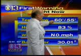
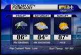
everything else is west of hagerstown. rain chances increase this afternoon. thunderstorms today and into saturday morning before things finally clear out. temperatures in the 80's over the weekend at ocean city. thunderstorms today could be heavy, severe. there is a flood watch in effect as well. tomorrow, high temperatures same as today, but lower humidity. >> at least the weekend will be good. thank you for joining us for 11 news at noon. >> follow breaking news and weather any time at wbaltv.com, and stay connected with us on facebook and twitter.
everything else is west of hagerstown. rain chances increase this afternoon. thunderstorms today and into saturday morning before things finally clear out. temperatures in the 80's over the weekend at ocean city. thunderstorms today could be heavy, severe. there is a flood watch in effect as well. tomorrow, high temperatures same as today, but lower humidity. >> at least the weekend will be good. thank you for joining us for 11 news at noon. >> follow breaking news and weather any...
305
305
tv
eye 305
favorite 0
quote 0
bryce harper promoted from hagerstown to aa harrisburg. he'll take the field tonight.ls gave fans a reason to celebrate early. it was jayson werth who provided the brightest of daytime fireworks as the nationals beat the cubs. it was an extremely festive 4th of july at the ballpark. but it didn't start that way for the nationals. top of the fourth, 2-1, former nats sorano pops up the shallow right. no one calls for it. jayson werth cannot decide so it falls. marlin bird is going to try. so the cubs take a 3-2 lead. werth, though, would atone for the gaffe later. so it's the bottom of the tenth now. tied at 4. carlos under the pitch. that is the winning run. the nationals beat the cubs 5-4 in ten innings. and he needed that, because he had been booed by nationals' fans as reasonabcently as yeste. so this is great for werth. but he is getting $126 million. >> yeah. don't feel too sorry for him. >> the nationals aren't the only team looking to get back to winning ways. d.c. united has only won at home one time. but head coach ben olson stopped by to tell us why that shoul
bryce harper promoted from hagerstown to aa harrisburg. he'll take the field tonight.ls gave fans a reason to celebrate early. it was jayson werth who provided the brightest of daytime fireworks as the nationals beat the cubs. it was an extremely festive 4th of july at the ballpark. but it didn't start that way for the nationals. top of the fourth, 2-1, former nats sorano pops up the shallow right. no one calls for it. jayson werth cannot decide so it falls. marlin bird is going to try. so the...
118
118
Jul 6, 2011
07/11
by
WBAL
tv
eye 118
favorite 0
quote 0
south of hagerstown, probably in the martinsburg area, other than that, hard to find a significant showers other than that loan schaller tracking through eastern baltimore county. it was certainly a hot day, temperatures into the 90's. on the record high for this day is hundred and two back in 1999. temperatures even he's here in town. the decrees. they did manage to get some cool, dry, comparable air in western maryland. 60 cosy and 70's. with this from the lingering in the region, as afternoon, the front still hang around in my lender into tomorrow evening. lake of to some clouds, warm and muggy. hello 90 cozy with a partly cloudy skies and 30%-40% of a the afternoon thunderstorm. it is kind of drifting back to the north and ike. it indicates we are on the warmer side of the front. they will be popping up along the day tomorrow. it becomes a more important front through the great lakes. in the front will be dropping in and to keep the thunderstorm changed. as we go into thursday afternoon, the left over front is the triggering showers. all of those are still in the area on friday. but wi
south of hagerstown, probably in the martinsburg area, other than that, hard to find a significant showers other than that loan schaller tracking through eastern baltimore county. it was certainly a hot day, temperatures into the 90's. on the record high for this day is hundred and two back in 1999. temperatures even he's here in town. the decrees. they did manage to get some cool, dry, comparable air in western maryland. 60 cosy and 70's. with this from the lingering in the region, as...
187
187
Jul 6, 2011
07/11
by
WUSA
tv
eye 187
favorite 0
quote 0
still 90 in leesburg. 90 in martinsburg and 91 out in hagerstown. our summer pattern will persist.muggy with possible storms tonight. hot and humid tomorrow. afternoon storms again tomorrow. and even a better chance of thunderstorms on friday. in fact, thursday night and friday may be the best chance for storms as the front is pretty much on top of us. for tonight again, we will keep the chance of a thunderstorm in. mainly early. more to the south and east. temperatures between 68 and 74. another muggy night. winds southwest at 10. lows tonight then looking at 69 in rockville but inside the beltway and downtown low to mid-70s. it will be a little bit on the muggy side. 74 downtown. 71 in colleges park. 70 in fort bellvoir. maybe 69 in fairfax. 70 though in reston. and 70 out in sterling. tomorrow morning, becoming partly cloudy and warm. we should stay dry tomorrow morning. i know we had showers this morning. i think we will be dry for the commute. temperatures in the 70s and 80s. air quality goes to code yellow. moderate air quality. and an improvement over today's air quality whi
still 90 in leesburg. 90 in martinsburg and 91 out in hagerstown. our summer pattern will persist.muggy with possible storms tonight. hot and humid tomorrow. afternoon storms again tomorrow. and even a better chance of thunderstorms on friday. in fact, thursday night and friday may be the best chance for storms as the front is pretty much on top of us. for tonight again, we will keep the chance of a thunderstorm in. mainly early. more to the south and east. temperatures between 68 and 74....
171
171
Jul 4, 2011
07/11
by
WUSA
tv
eye 171
favorite 0
quote 0
only 82 in winchester and hagerstown. cumberland is 79. clouds are thicker up here. in town we were at 85. when you factor in the humidity, it feels more like 88 here. heat index up to 95 right now in richmond. it's a steamy day down. there 58 with the clouds. feeling like 88. a light wind. winds are light all day. variable. right now north, northeast at 3. with the dew points in the upper 60s, that's the muggies. the muggies are back. look at the showers coming in off baja, california, across the arizona, nevada, border headed toward las vegas if they can make the trip north a little bit more. then we have showers and storms lining up from eastern oklahoma. arkansas, right here across the ohio river. aheaded toward eastern, kentucky. the strong ones are moving toward central and southern virginia. northcarolina. much higher threat they will see strong thunderstorms. got one watch box up here in new england until 8:00 p.m. but the stuff in southern ohio that has me a little concerned that if it holds together could give us some problems this afternoon. right now the
only 82 in winchester and hagerstown. cumberland is 79. clouds are thicker up here. in town we were at 85. when you factor in the humidity, it feels more like 88 here. heat index up to 95 right now in richmond. it's a steamy day down. there 58 with the clouds. feeling like 88. a light wind. winds are light all day. variable. right now north, northeast at 3. with the dew points in the upper 60s, that's the muggies. the muggies are back. look at the showers coming in off baja, california, across...
215
215
Jul 1, 2011
07/11
by
WTTG
tv
eye 215
favorite 0
quote 0
. >> visiting hagerstown. he's going to get here quick, so i think it's a have till situation for anybody, really. >> talking about the present. after six games on the road and a 2-4 record to show for it, the nationals not just excited to be back, but excited to get in another hot winning streak. >> i think it's always nice to get home. we're where we need to be before the all-star break. we have a good home stand, take a few games off and get ready for the second. >> just think, if we have a winning home -- >> i think that's important. we do that, above 500 going into the saul star break, and anything can happen in second half. >> from the field to the ice we go, free agency underway in the nhl, but the capitals chose to make an old-fashioned trade, sending carlo off to the avalanche in exchange for a first-round pick and a pick in the future draft. roman hammerlick signed to a new contract as well as bringing back frank hall person. the semifinals at wimbledon and rafael nadal does it again. nadal, who's kn
. >> visiting hagerstown. he's going to get here quick, so i think it's a have till situation for anybody, really. >> talking about the present. after six games on the road and a 2-4 record to show for it, the nationals not just excited to be back, but excited to get in another hot winning streak. >> i think it's always nice to get home. we're where we need to be before the all-star break. we have a good home stand, take a few games off and get ready for the second. >>...
202
202
tv
eye 202
favorite 0
quote 0
tried to contact the pilot but he didn't respond and that's when fighter jets escorted the plane to hagerstownobamas are at camp david for the weekend. the last time they were there, fighter jets had to intercept another plane that entered the air. both cases are believed to be accidents. >>> sending the wrong message. >> the army says "no thanks" to a new running trend. >>> and we could see some strong storms this holiday weekend. stor[ coach ] in albuquerque, citi pre-approved my mortgage. [ whistle blows ] all right, layups, guys. let's go. in sioux falls, i locked in a rate. coach, you get that house yet? working on it. [ coach ] the appraisal? ...springfield. wherever i was, my citi mortgage consultant had me covered. [ crowd cheering ] and 500 miles from home... [ cheering, cellphone beeps ] ...we finally had a new home. [ male announcer ] from pre-approval to closing, citi is with you every step of the way. what's your story? citi can help you write it. >>> prince william and kate's north america trip continued today with a visit to a children's hospital in montreal. a small group of pr
tried to contact the pilot but he didn't respond and that's when fighter jets escorted the plane to hagerstownobamas are at camp david for the weekend. the last time they were there, fighter jets had to intercept another plane that entered the air. both cases are believed to be accidents. >>> sending the wrong message. >> the army says "no thanks" to a new running trend. >>> and we could see some strong storms this holiday weekend. stor[ coach ] in albuquerque,...
212
212
Jul 3, 2011
07/11
by
WBAL
tv
eye 212
favorite 0
quote 0
the line is beginning to reach towards hagerstown. everything is drifted in this direction. much bigger storms in cleveland. these are strong and a lot of lightning. that's also moving to the southwest, too. there is a cold front approaching. that is what is increasing our rain chances here. we'll have the rain chances for better than 24 hours in the area. so a piece of ts holiday weekend does have a rain threat. let's take a look at the current temperatures outside. it's a warm evening this evening. mid 70's to around 80 degrees around the bay, most of the yellow shaded areas, you see a few areas of orange, closer to 80. those are in the city itself, especially in the district of columbia. the green shades indicate what readings have dropped into the 60's to a great extent. as far as the satellite imagery is concerned, we have a deck of clouds over us, it's thin and that is not rain, false echos on the radar. here are the storms in pennsylvania. those big storm clusters, two of them, one over lake erie and one out over indiana. indiana has had several periods of rain over t
the line is beginning to reach towards hagerstown. everything is drifted in this direction. much bigger storms in cleveland. these are strong and a lot of lightning. that's also moving to the southwest, too. there is a cold front approaching. that is what is increasing our rain chances here. we'll have the rain chances for better than 24 hours in the area. so a piece of ts holiday weekend does have a rain threat. let's take a look at the current temperatures outside. it's a warm evening this...
177
177
Jul 4, 2011
07/11
by
WUSA
tv
eye 177
favorite 0
quote 0
meanwhile their number one draft pick promoted today from low a hagerstown to aa harrisburg. 14 home runs, 46 ribs in his 72 games with the suns. odds are he gets the aaa sir cues and probably joins the nats sometimes next season. the average american male takes in about 2500 calories per day. that means the guy who won the hot dog eating contest on coney island consumed in ten minutes what most of us would eat in nine days. they don't mention it, but it's one of the reasons we fought the revolution. it's as american as apple pie and one of the most absurd american traditions, the nathan's hot dog eating contest. who can stuff the most processed meat in their mouths in ten minutes. and joey chestnut, american hero wins the face jam 62 dogs consumed. he is officially a one-man dynasty and i think he is sponsored by pepto. certainly a promotional opportunity for them. >> do they even know what's in those dogs? if they even knew what was in those hot dogs, would they really eat that many? >> there are two things you never want to see made, sausage and television. you don't want to know
meanwhile their number one draft pick promoted today from low a hagerstown to aa harrisburg. 14 home runs, 46 ribs in his 72 games with the suns. odds are he gets the aaa sir cues and probably joins the nats sometimes next season. the average american male takes in about 2500 calories per day. that means the guy who won the hot dog eating contest on coney island consumed in ten minutes what most of us would eat in nine days. they don't mention it, but it's one of the reasons we fought the...
174
174
Jul 5, 2011
07/11
by
WUSA
tv
eye 174
favorite 0
quote 0
north and west, up in frederick, cumberland, hagerstown. you may sneak by tomorrow without seeing anything. parts of winchester, martinsburg. as we head into thursday, as that front from the midwest, the one with the storms, look what happens thursday afternoon. scattered showers and storms and i think we'll see about the same for friday as well before drying out by the weekend. that means temperatures will start to arrive. today around 91. lots of sunshine. spotty storm or two at worse. tomorrow, scattered showers and storms with a better chance south of town, 89. on thursday, scattered showers and storms more widespread again in the upper 80s. about the same on friday. saturday, here's your weekend. got a chance of a storm dropping though 91. here comes more heat and drier air. sunday and monday, low to mid- 90s. we've got some is good chocolate stuff in the kitchen! i've been sampling it. 9news now will return. >> we have some wicked treats in our 9news now kitchen to celebrate the return of the tony award winning musical, wicked. we wel
north and west, up in frederick, cumberland, hagerstown. you may sneak by tomorrow without seeing anything. parts of winchester, martinsburg. as we head into thursday, as that front from the midwest, the one with the storms, look what happens thursday afternoon. scattered showers and storms and i think we'll see about the same for friday as well before drying out by the weekend. that means temperatures will start to arrive. today around 91. lots of sunshine. spotty storm or two at worse....
196
196
tv
eye 196
favorite 0
quote 0
harper has been a machine at the plate. 14 home runs, 46 rbi and 19 stolen bases with hagerstown.t excited, and think he could be up in the nation's capital soon, not so fast. the nationals say this was part of the plan all along. they acknowledge he has had to make some adjustments, including learning this is something you do not do in professional baseball. remember this, when he did the kiss to the pitcher? yes. that is something they have certainly talked to him about. however, general manager mike rizzo says this is all right on schedule. >> we always have a timetable for him, felt that, you know, when we felt it was time for him to take the next step and to, you know, challenge him a little bit further, we would make a smooth transition, and, you know, after he went through a few of the little injuries, showed me that enough at-bats at that level, and succeeded at that level enough, we figured we would challenge him to the next level in the minor leagues. >>> the nationals want harper to play in the arizona fall league next. they also want him to get some experience in aaa.
harper has been a machine at the plate. 14 home runs, 46 rbi and 19 stolen bases with hagerstown.t excited, and think he could be up in the nation's capital soon, not so fast. the nationals say this was part of the plan all along. they acknowledge he has had to make some adjustments, including learning this is something you do not do in professional baseball. remember this, when he did the kiss to the pitcher? yes. that is something they have certainly talked to him about. however, general...
193
193
Jul 7, 2011
07/11
by
WUSA
tv
eye 193
favorite 0
quote 0
cooler up to the north. 80 in baltimore. 75 in hagerstown. there is a cold front on the map.it will sink south. it will take a long time to get south of us. probably take until saturday morning. muggy with storms tonight. more storms tomorrow. some could be heavy. flash flood watch goes into effect tomorrow. and hot over the weekend but less humid. a little bit more comfortable. for tonight then, mostly cloudy, muggy, showers and thunderstorms possible. 68 to 74. we will revisit how many storms we think will happen overnight tonight at 11 p.m. by morning, some storms are still possible. could be a wet commute going and coming to work. 70s and 80s. winds out of the southwest at 10. then by afternoon a real good chance of showers and thunderstorms. not as hot. flash flood watch goes into effect. high temperatures around 85. now, the next seven days. once we get through tomorrow maybe a leftover shower on saturday but really not a bad weekend. upper 80s on saturday to near 90. 90 on sunday but less humid. hot on monday. back in the mid-90s. and pretty strong cold front rolls thr
cooler up to the north. 80 in baltimore. 75 in hagerstown. there is a cold front on the map.it will sink south. it will take a long time to get south of us. probably take until saturday morning. muggy with storms tonight. more storms tomorrow. some could be heavy. flash flood watch goes into effect tomorrow. and hot over the weekend but less humid. a little bit more comfortable. for tonight then, mostly cloudy, muggy, showers and thunderstorms possible. 68 to 74. we will revisit how many storms...
196
196
Jul 7, 2011
07/11
by
WUSA
tv
eye 196
favorite 0
quote 0
one storm approaching hagerstown and one storm the source of some severe thunderstorm warnings early into hampshire county and mineral county, west virginia. this storm around frederick is pretty hefty. just kind of parallelling i-70 headed towards winfield. heavy rainfall. no hail with these storms just yet but there is a pretty heavy storm up i-81 and this is moving off to the east. around hedgesville right now. this is a pretty good rainfall. 1 to 2 inches per hour around 9 p.m. and headed just to the south of williamsport. we will come back and track the rest of the storm for you. a cold front on the map as well. we will tell you when a flash flood watch goes into effect as well. >>> next wednesday casey anthony will walk out of the florida jail she has called home for nearly three years. today a judge sentenced the 25- year-old to four years for lying to investigators after her daughter went missing in 2008. the time she has already served coupled with good behavior means she will be released in six days. anthony will also have to pay a $4000 fine. on tuesday a jury acquitted he
one storm approaching hagerstown and one storm the source of some severe thunderstorm warnings early into hampshire county and mineral county, west virginia. this storm around frederick is pretty hefty. just kind of parallelling i-70 headed towards winfield. heavy rainfall. no hail with these storms just yet but there is a pretty heavy storm up i-81 and this is moving off to the east. around hedgesville right now. this is a pretty good rainfall. 1 to 2 inches per hour around 9 p.m. and headed...
166
166
Jul 4, 2011
07/11
by
WTTG
tv
eye 166
favorite 0
quote 0
he ripped up the pitching in single-a ball hit ago .318 in hagerstown, 14 homers and 46 rbis, he's expected to play primarily in west feel with the promotion and nats selected them as the overall picks in the draft. and a 4th of july holiday tradition. the hot dog-eating contest. and competing in the first ever all-women's competition and show did it in style. downing 40 hot dogs and buns in 10 minutes to get that beautiful pension trophy. on the men's side, how about joey chest nut? he didn't disappoint. 62 dogs andy the minutes to make yet five toolings in a row. the only downside, he could not top his own record of 68 and that, my friend is disgusting. i am just full from watching that, mien from. i don't know about you, i'm not having a hot dog any time soon. >> i can't believe that is an american tradition new j. i don't know how it started but it's here to say. >> i would like to celebrate my independence from those videos. >> fare enough. no more hot dog viewing for you. >> okay. >>> dave ross, thanks for. that gary, one last look at the forecast. >> and a chance of a shower and thun
he ripped up the pitching in single-a ball hit ago .318 in hagerstown, 14 homers and 46 rbis, he's expected to play primarily in west feel with the promotion and nats selected them as the overall picks in the draft. and a 4th of july holiday tradition. the hot dog-eating contest. and competing in the first ever all-women's competition and show did it in style. downing 40 hot dogs and buns in 10 minutes to get that beautiful pension trophy. on the men's side, how about joey chest nut? he didn't...
141
141
Jul 6, 2011
07/11
by
WUSA
tv
eye 141
favorite 0
quote 0
little warmer to the north and west actually. 88 in leesburg. 89 in hagerstown. the game is underway. you have time to run down to nats park and see it. taken showers out. partly cloudy, warm and muggy. daytime time temperatures 80 to 85 as we host the cubs. winds southwest at about 10. for us tonight just look for partly cloudy skies and muggy, patchy fog late. mid-70s. we will come back and talk about a cold front. we will tell you what that means for your morning and evening commute tomorrow. >>> a plane goes down in virginia shattering into pieces. but what happened next? we will tell you about it right after this. >>> dc mayor vincent gray chiming in on the metro debate saying he favors an above ground parking lot at the dulles and is urging council members to switch their votes. an underground station would cost $300 million more. >>> the driver in may's deadly tour bus accident in virginia pleaded not guilty today to four involuntary manslaughter charges. 37-year-old cheung admitted he fell asleep when the sky express bus overturned on i-95 north of richmo
little warmer to the north and west actually. 88 in leesburg. 89 in hagerstown. the game is underway. you have time to run down to nats park and see it. taken showers out. partly cloudy, warm and muggy. daytime time temperatures 80 to 85 as we host the cubs. winds southwest at about 10. for us tonight just look for partly cloudy skies and muggy, patchy fog late. mid-70s. we will come back and talk about a cold front. we will tell you what that means for your morning and evening commute...
218
218
tv
eye 218
favorite 0
quote 0
that's going to be the trend over the next few days. 79 in hagerstown. 73 in culpepper. leonardtown, 73 degrees. not going to see any rain overnight tonight. a slight chance of a shower or two as the frontal boundary to our north begins to make its way down to the south. a couple of showers trying to make their way toward western maryland. that's about it. but these two front, one to our south, another to our north, those will provide a focal point tomorrow to give us the shower and thunderstorm opportunity. i'm not looking for a lot in the way of severe weather. but any thunderstorms that do develop could produce very heavy downpours for a time period. so we could be seeing some localized flooding. very warm and humid conditions remain. as the front lingers, an area of low pressure moves along. on friday, depending on where that area of low pressure moves and develops, friday could be a fairly wet day for some of us. not everybody is going to be getting wet. tomorrow morning, mostly sunnily clear, warm and humid. 67 to about 74 degrees. there could be a few areas of fog
that's going to be the trend over the next few days. 79 in hagerstown. 73 in culpepper. leonardtown, 73 degrees. not going to see any rain overnight tonight. a slight chance of a shower or two as the frontal boundary to our north begins to make its way down to the south. a couple of showers trying to make their way toward western maryland. that's about it. but these two front, one to our south, another to our north, those will provide a focal point tomorrow to give us the shower and...
160
160
Jul 8, 2011
07/11
by
WMAR
tv
eye 160
favorite 0
quote 0
a slow mover, not severe, but enough to produce flooding, there is another line brewing towards hagerstown. we will be watching us into tomorrow. them to flash flood warning is left to the next hour or two that will be baltimore county, baltimore city as that moves north and a flash flood watch through the entire area tomorrow. we have one indicator where we picked up more than 3 inches of rain. we had one spot on the east side of baltimore. we captured the us guys turning unsettled as the storm system came into baltimore in the evening, reaching all the way into the inner harbor. a stormy scenario here in as we work into the evening hours. right now, things are relatively quiet downtown as you go north of the city, things change quickly. 75 in the wake of the storm's humidity, average as lehigh, 80- 90% humidity. it is a scheme that. this will shift slowly south tomorrow and. >> another focusing point for showers and storms on and off through the day tomorrow. you see this boundary draped across the east coast and hot, humid air surging northward. the battery will move slowly southward an
a slow mover, not severe, but enough to produce flooding, there is another line brewing towards hagerstown. we will be watching us into tomorrow. them to flash flood warning is left to the next hour or two that will be baltimore county, baltimore city as that moves north and a flash flood watch through the entire area tomorrow. we have one indicator where we picked up more than 3 inches of rain. we had one spot on the east side of baltimore. we captured the us guys turning unsettled as the...
155
155
Jul 5, 2011
07/11
by
WUSA
tv
eye 155
favorite 0
quote 0
hagerstown cooling down to 68 degrees. tomorrow morning as you are heading out the door, partly to mostly cloudy conditions and mild. remember a slight chance for some showers, better chances to the south. temperatures in the 60s and 70s. now tomorrow afternoon, yes, pack the umbrella just in case because we could see some scattered showers and thunderstorms tomorrow. highs will be near 90 and because the winds coming from the south at 5 to 10. the humidity increasing. so we are warming up to the near 90s around downtown. gaithersburg 92. culpeper 93 degrees. here's how your day planner breaks down. already in the 80s and then by 5:00, chance of showers and thunderstorms scattered. here's your seven-day outlook. a very typical july pattern here. temperatures around seasonal. but notice we won't warm things up. a burst of heat comes through monday and tuesday as of now and those days look storm-free except for tuesday into the mid 90s on tuesday. so the heat is back on. >> this was a normal season, the redskins would be get
hagerstown cooling down to 68 degrees. tomorrow morning as you are heading out the door, partly to mostly cloudy conditions and mild. remember a slight chance for some showers, better chances to the south. temperatures in the 60s and 70s. now tomorrow afternoon, yes, pack the umbrella just in case because we could see some scattered showers and thunderstorms tomorrow. highs will be near 90 and because the winds coming from the south at 5 to 10. the humidity increasing. so we are warming up to...
231
231
Jul 7, 2011
07/11
by
WMAR
tv
eye 231
favorite 0
quote 0
dulles at 72 and also winchester more of the same in hagerstown. 66 right now in york, pennsylvania andthat's the dew point temperature in pennsylvania as well. so if you are driving up that way, you will run into patchy fog across the area. so 69 degrees right now for a dew point in baltimore. 70 in washington. culpepper around 73 as well. and we have patchy fog across the area. and satellite and radar not picking up on a whole lot right now. again, we are mainly clear but what happens is we will have a cold front that's trying to push closer to us. but what's going to happen is once again is it's going to stall out a lot of stationary fronts and with that, that's the focal point. as we go through afternoon today and also tomorrow, behind that front, though, yes, we are getting drier air in here. just in time for the weekend. and future radar showing you what's happening asway go through the afternoon. you can see the chance for showers and thunderstorms to pop around us once again. and then tomorrow, it's going to be the better chance for the showers and thunderstorms. we could start
dulles at 72 and also winchester more of the same in hagerstown. 66 right now in york, pennsylvania andthat's the dew point temperature in pennsylvania as well. so if you are driving up that way, you will run into patchy fog across the area. so 69 degrees right now for a dew point in baltimore. 70 in washington. culpepper around 73 as well. and we have patchy fog across the area. and satellite and radar not picking up on a whole lot right now. again, we are mainly clear but what happens is we...
 Live Music Archive
 Librivox Free Audio
 Metropolitan Museum
 Cleveland Museum of Art
 Internet Arcade
 Console Living Room
 Open Library
 American Libraries
 TV News
 Understanding 9/11