266
266
Oct 15, 2010
10/10
by
WRC
tv
eye 266
favorite 0
quote 0
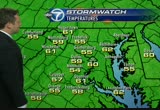
martinsburg, around 41. you add in the wind 15 to 20 miles an hour, you're talking about a winchester of about 35 by tomorrow morning. it will definitely be on the cool side. tonight may be a night topen up thoseindows to get that fall air in there. you may want to close those windows and turn on that heat. high pressures for the day, 64 in frederick. in martinsburg. a lot warmer to the south. fredericksburg, 68 in saint mary's. upper marlboro around 62 degrees. as far as some events tomorrow, here's a good one. the international goal cup races. 73nd running in warrenton tomorrow. all day omorrow, a great time for the family. they'll be having all kinds of horse racing. 62 to 65 degrees if you want to head to the west. a beautiful day out there. a little on the windy side. breezy conditions during the day on saturday. sunday with a high temperature of3. sun will be the best day. thwinds will begin to subside. a little breezy but 10 to 15 miles an hour is a lot better than 30 tomorrow. on monday we'll be cool
martinsburg, around 41. you add in the wind 15 to 20 miles an hour, you're talking about a winchester of about 35 by tomorrow morning. it will definitely be on the cool side. tonight may be a night topen up thoseindows to get that fall air in there. you may want to close those windows and turn on that heat. high pressures for the day, 64 in frederick. in martinsburg. a lot warmer to the south. fredericksburg, 68 in saint mary's. upper marlboro around 62 degrees. as far as some events tomorrow,...
256
256
Oct 25, 2010
10/10
by
WJLA
tv
eye 256
favorite 0
quote 0
right now, west of winchester and martinsburg. a couple of heavy downpours their trip -- a couple of heavy downpours there. let's go to the weatherbug and become a couple of reports around the area. 72 degrees in asheville. 71 in the hunting down -- hunting down. 76 was the high. 76 at reagan national. we had been as warm as 80 degrees. that was the record set back in 1802. this is a byproduct of this storm center developing way out to the west, keeping temperatures will be warmer than they should be this time of year. there's plenty of warm air as you head west and southwest. you can start to see changes here. just to the east of that, much warmer temperatures developing. in the spring time you have spring storms develop. the result is going to be a major storm. plenty of showers and storms, but they have stayed just to the south and another-just to the north. mid to upper 70's on wednesday. by wednesday, we start to feel the effects of a cold front that emanates out from the big storm out --west. breaks in the clouds to give us
right now, west of winchester and martinsburg. a couple of heavy downpours their trip -- a couple of heavy downpours there. let's go to the weatherbug and become a couple of reports around the area. 72 degrees in asheville. 71 in the hunting down -- hunting down. 76 was the high. 76 at reagan national. we had been as warm as 80 degrees. that was the record set back in 1802. this is a byproduct of this storm center developing way out to the west, keeping temperatures will be warmer than they...
158
158
Oct 7, 2010
10/10
by
WUSA
tv
eye 158
favorite 0
quote 0
hagerstown, martinsburg. oakland only 50 but they are at 3,000 feet. everybody else upper 60s to low 70s. frederick might be in the upper 70s the way we're going this afternoon. national 72. mostly sunny skies with a sustained wind out of west/northwest at 14. barometer continues to rise. and nationally, we're watching this, got the storm out west. remember all the storms in arizona the last few days with the tornadoes yesterday. the storm in the northeast but in between there's nothing. nothing coming toward us. that is the case for the next several days. we have this front but it's falling apart. weatherwise there's no significant weather headed this way. i'm looking at the 9 futurecast. you'll see the rains in new england leave. as we head into tonight and tomorrow and tomorrow night it's nice and quiet and clear. that is going to set the stage for a great weekend. 75 or so in downtown. 78 culpeper. 77 fredericksburg. low 70s for parts of the shenandoah valley. our 7-day forecast, a nice one. today, again, only 75. only 75. that is because tomorrow
hagerstown, martinsburg. oakland only 50 but they are at 3,000 feet. everybody else upper 60s to low 70s. frederick might be in the upper 70s the way we're going this afternoon. national 72. mostly sunny skies with a sustained wind out of west/northwest at 14. barometer continues to rise. and nationally, we're watching this, got the storm out west. remember all the storms in arizona the last few days with the tornadoes yesterday. the storm in the northeast but in between there's nothing....
205
205
Oct 14, 2010
10/10
by
WUSA
tv
eye 205
favorite 0
quote 0
or 878 departing martinsburg at 63 o. it will hold at the brunswick station until 7:40 this morning. other alternatives include taking 991 or the montgomery county ride on with service to rockville and silver spring. what caused all of these cancellations? unfortunately police say it was an apparent suicide. yesterday afternoon, a freight train struck and killed a man who had been on the tracks sow of the rockville station. that shut down the line for several hours during the heart of the rush. which meant many of the marc train crews were not able to have their federally mandated eight hours of time off duty last night. marc does of course have some stand by crews but not enough to stand at normal levels this morning. so the mta says they are planning on being back up and running. all trains in service, hopefully in time for the evening rush today. but keep in mind they are warning that more train cancellations could be coming. so that is something that we are certainly going to want to watch for if you do indeed use the
or 878 departing martinsburg at 63 o. it will hold at the brunswick station until 7:40 this morning. other alternatives include taking 991 or the montgomery county ride on with service to rockville and silver spring. what caused all of these cancellations? unfortunately police say it was an apparent suicide. yesterday afternoon, a freight train struck and killed a man who had been on the tracks sow of the rockville station. that shut down the line for several hours during the heart of the rush....
296
296
Oct 11, 2010
10/10
by
WTTG
tv
eye 296
favorite 0
quote 0
. >> reporter: montgomery county officers say the last known address of jones was in martinsburg, west virginia. anyone with information is asked to call the police. >>> a cool night. and another gorgeous day. the forecast looking pretty good for the week ahead. a live look outside right now. gwen tolbart is in the weather center for the forecast. good news if you were correct at 6 and that still stands but change on the way as well. >> definitely. always changes with mother nature, will. as we go into the holiday weekend people are keeping their fingers crossed we will have a really good columbus day. the temperatures we reach for the day-time highs because once again above seasonal. 79 at dulles kind of flirting with that 80-degree mark. at baltimore 76 degrees. a ridge of high pressure is building in. we are also going to have to be dealing with a frontal system that's going to make some changes in our forecast. our current temperatures are pretty comfortable, 69 at washington, d.c. mild outside. we have got 68 in annapolis. 68 in baltimore. 65 at dulles. 71 to the west in martinsbu
. >> reporter: montgomery county officers say the last known address of jones was in martinsburg, west virginia. anyone with information is asked to call the police. >>> a cool night. and another gorgeous day. the forecast looking pretty good for the week ahead. a live look outside right now. gwen tolbart is in the weather center for the forecast. good news if you were correct at 6 and that still stands but change on the way as well. >> definitely. always changes with...
246
246
Oct 5, 2010
10/10
by
WTTG
tv
eye 246
favorite 0
quote 0
to the west, 49 at martinsburg and 51 at winchester and annapolis. highs will be into the 60s or so but once again, still a lot cooler than what we actually should be in terms of our temperatures. today, we'll see some sunshine this morning. so not a bad start. a little bit of a break but clouds will start to roll in by the time we hit the afternoon hours. be prepared for that. i can't give you much sunshine this afternoon so enjoy it this morning. the other side is at least we have drier conditions for you outside. today's forecast, partly sunny and then mostly cloudy. our daytime high, 63 degrees. >>> a man was found shot in the parking lot of the huntington metro station in alexandria. the call came in about 10:30 last night ate woman tells police she was supposed to meet the man there. officers arrived to found him shot in the stomach in his car. it is not clear the shooting happened. he was transported to the hospital with life-threatening injuries. >>> a new but limited study by maryland's health department found there is no cancer clufter in f
to the west, 49 at martinsburg and 51 at winchester and annapolis. highs will be into the 60s or so but once again, still a lot cooler than what we actually should be in terms of our temperatures. today, we'll see some sunshine this morning. so not a bad start. a little bit of a break but clouds will start to roll in by the time we hit the afternoon hours. be prepared for that. i can't give you much sunshine this afternoon so enjoy it this morning. the other side is at least we have drier...
346
346
Oct 25, 2010
10/10
by
WJLA
tv
eye 346
favorite 0
quote 1
stifel in gaithersburg, 16 quantico. 50 in baltimore. 49 in martinsburg, 46 in frederick. average height is 65. we are starting close to that at reagan national. it will be a warm day. areas of rain down to our south. that will continue tracking to the north and east. that will bring energy along with it. that will contain showers and thunderstorms for this afternoon and evening. mid 70's today. partly cloudy tomorrow, still seven days. another round of slain -- rain by wednesday. >>> fender benders on 95 in virginia, moved to the silda. inner loop at pennsylvania, that is out of the lake. braddoc -- out of the way. 95 was closed out of baltimore, but then has been reopened. moving slowly on the beltway at university blvd.. that is the outer loop side. >>> there's a new game for pets, putting them in a rare spotlight. >>> today on "oprah," their lives were shattered in an instant, then a miraculous twist of fate, at 4:00 on abc 7. >>> 6:25. an influential medical group wants doctors to screen new mothers for depression. the american academy of pediatrics published and repo
stifel in gaithersburg, 16 quantico. 50 in baltimore. 49 in martinsburg, 46 in frederick. average height is 65. we are starting close to that at reagan national. it will be a warm day. areas of rain down to our south. that will continue tracking to the north and east. that will bring energy along with it. that will contain showers and thunderstorms for this afternoon and evening. mid 70's today. partly cloudy tomorrow, still seven days. another round of slain -- rain by wednesday. >>>...
253
253
Oct 10, 2010
10/10
by
WTTG
tv
eye 253
favorite 0
quote 0
the same at frederick; 57, martinsburg and to the south, 59 and 61 degrees in annapolis this hour and 57 in baltimore. the skies are clear as well and that is because the ridge of high pressure is in control. look at the tropics, things have started to calm down a lot. the category 1 hurricane downgraded to a tropical storm with maximum sustained winds at 70 miles per hour and that is headed to the atlantic and no threat whatsoever with no warnings or watches and is expected to continue weakening through into the next 24 hours or so and the ridge of high pressure in control, the mid- atlantic is benefitting and with very, very clear skying. things are about to change. we have a frontal system and this is the cold front starting to go to the the south and it will be a warm front and move back to the north. as we go into tomorrow, that is what is going happen and we're going to get a bit of a southerly flow and then we're going to end up seeing again, move to the south and that will create a disturbance. we could see a few showers in the forecast. and back to the weatherria. as far as t
the same at frederick; 57, martinsburg and to the south, 59 and 61 degrees in annapolis this hour and 57 in baltimore. the skies are clear as well and that is because the ridge of high pressure is in control. look at the tropics, things have started to calm down a lot. the category 1 hurricane downgraded to a tropical storm with maximum sustained winds at 70 miles per hour and that is headed to the atlantic and no threat whatsoever with no warnings or watches and is expected to continue...
169
169
Oct 8, 2010
10/10
by
WJLA
tv
eye 169
favorite 0
quote 0
nothing unsettled to it. 54 right now at reagan national. 45 in martinsburg. cumberland the cool spot on this map at 41. hagerstown though 56. frederick at 45. annapolis 53 degrees. we are high and dry. you can see the clear skies. we will continue to see clear skies for the next several days. even a cloud on the satellite image locally. you have to go up to parts of new england and that is where it is with the upper level disturbance -- my goodness, look at my arrows. let's try that again. there we go. upper level disturbance. that was overhead the past several days and is pushing northeast. learning process slowly getting better. high pressure is influencing our weather. it is over missouri and that is close enough to give us sunshine the next several days. basically mostly sunny today through the weekend. by the early part of next week we will see shift in the pattern. at that point we have a chance of showers but not until tuesday. for today sunshine, mild, above average. temperatures in the mid to upper 70's, near 80. tonight dropping down into the 50's.
nothing unsettled to it. 54 right now at reagan national. 45 in martinsburg. cumberland the cool spot on this map at 41. hagerstown though 56. frederick at 45. annapolis 53 degrees. we are high and dry. you can see the clear skies. we will continue to see clear skies for the next several days. even a cloud on the satellite image locally. you have to go up to parts of new england and that is where it is with the upper level disturbance -- my goodness, look at my arrows. let's try that again....
192
192
Oct 10, 2010
10/10
by
WTTG
tv
eye 192
favorite 0
quote 0
and that is 65 degrees. 55, fredericksburg and 65 degrees at hagerstown and 60 to the west and martinsburg; 59, winchester and cooler to the north in new england, 51 degrees for boston and new york at 60 degrees and have done well in the course overall and a ridge of high pressure that is in control. let's look at otto, what was category 1 hurricane and that is downgraded to a tropical storm and maximum sustained winds and weakened out over the course of the evening and it's now -- with a bit as it moves to the north-northeast over the atlantic and expect it to continue and there are no warnings or watches. and otto's going to be a has been story and that rim of high pressure into the clear and we have something else and that is that frontal system here. the cold front to the north and slowing to the south overnight. it will be a warm front and is going to move back again into sunday. and on monday, going to see a difference in her weather pattern and go back to the weather map and we'll put this together for you and a bit of a southerly breeze and tomorrow, the temperatures are going to b
and that is 65 degrees. 55, fredericksburg and 65 degrees at hagerstown and 60 to the west and martinsburg; 59, winchester and cooler to the north in new england, 51 degrees for boston and new york at 60 degrees and have done well in the course overall and a ridge of high pressure that is in control. let's look at otto, what was category 1 hurricane and that is downgraded to a tropical storm and maximum sustained winds and weakened out over the course of the evening and it's now -- with a bit...
235
235
Oct 11, 2010
10/10
by
WTTG
tv
eye 235
favorite 0
quote 0
temperatures right now are concerned, still pretty comfortable outside. 69 at dc. 68 at baltimore. 69 at martinsburg. let's take a look at the radar. we've got a frontal system to talk about. a ridge of high pressure is building in as we move through into tomorrow. but look at this front. very slowly taking its time. it is going to start to sag to the south. and then it will move back to the north as a cold front. and then move back down again. and it is going to be a big player in terms of our weather pattern over the next couple of days or so. so as we go back to our weather maps then. let's put it all together for you and show you exactly what's happening. this ridge of pressure building in for your columbus day plenty of sunshine. absolutely a very nice day. we have got this front that will start to slide its way through. we have got a chance of seeing some rain showers, especially into tuesday. but there is a chance we could see some of these kicking up late into monday night. there is also a chance that by tuesday and monday night as well that one or two of these storms could become severe. we
temperatures right now are concerned, still pretty comfortable outside. 69 at dc. 68 at baltimore. 69 at martinsburg. let's take a look at the radar. we've got a frontal system to talk about. a ridge of high pressure is building in as we move through into tomorrow. but look at this front. very slowly taking its time. it is going to start to sag to the south. and then it will move back to the north as a cold front. and then move back down again. and it is going to be a big player in terms of our...
236
236
Oct 24, 2010
10/10
by
WJLA
tv
eye 236
favorite 0
quote 0
as we live in our view a bit, there is cloud cover outside. 51 degrees in martinsburg, west virginia. 61 degrees in indianapolis. 45 in albany. cooler air could eventually make its way to our area by the end of this upcoming work week. we have a ways to go. everything is moving in our direction. the clouds and rain will hold off until monday. we may just see a few thunderstorms on monday. he made at unstable air will move back into the area. -- he made and unstable air will move back into the ebert -- humid and unstable air will move back into the area. by wednesday, more showers in the forecast and to work -- and cooler temperatures might thursday and friday. partly cloudy skies for the overnight hours. to mergers in the mid 50's downtime. by afternoon, high temperatures in the mid-70's. here is the senate outlook. looking nice if you do not mind a few showers here or there. cooler by the end of the upcoming work week. >> coming up on abc 7 news at 11:00, [ son ] my parents have always lived in the states. until two years ago, when my dad transferred to istanbul. they settled in quic
as we live in our view a bit, there is cloud cover outside. 51 degrees in martinsburg, west virginia. 61 degrees in indianapolis. 45 in albany. cooler air could eventually make its way to our area by the end of this upcoming work week. we have a ways to go. everything is moving in our direction. the clouds and rain will hold off until monday. we may just see a few thunderstorms on monday. he made at unstable air will move back into the area. -- he made and unstable air will move back into the...
224
224
Oct 8, 2010
10/10
by
WJLA
tv
eye 224
favorite 0
quote 1
at reagan we are 58 currently. 48 in martinsburg. cumberland 45. pax river naval air station 57 degrees. mostly sunny today, mid to upper 70's for most of us. cooler along the water. front royal 78. d.c. 78 for a high. we will talk more about the weekend coming up. now to jim. >> there is a late clearing construction zone near northeast. according to police the ramp from the southbound baltimore washington parkway to inbound new york avenue is blocked because of construction. there is a construction zone on kenilworth southbound at the district line where two of three lines are blocked. otherwise we are in pretty good. 95 good from fredericksburg to the beltway both ways. no accidents here. no accidents on the beltway north of town which looks good from college park to silver spring. back to you. >> our top story, a horrifying discovery in a fairfax station home. family members found a relative murdered in his home. it was thursday afternoon. courtney robinson has the story. >> a 61-year-old man found dead and police officers are investigating. >>
at reagan we are 58 currently. 48 in martinsburg. cumberland 45. pax river naval air station 57 degrees. mostly sunny today, mid to upper 70's for most of us. cooler along the water. front royal 78. d.c. 78 for a high. we will talk more about the weekend coming up. now to jim. >> there is a late clearing construction zone near northeast. according to police the ramp from the southbound baltimore washington parkway to inbound new york avenue is blocked because of construction. there is a...
231
231
Oct 5, 2010
10/10
by
WJLA
tv
eye 231
favorite 0
quote 0
we are in the 40's mostly. 47 clarksburg. 50 martinsburg. laplata 43 and manassas 47.ing clouds. 3eu6 for the high -- 63 for the high. variable cloud cover because some areas are clear and some areas west total cloud cover. tomorrow mostly cloudy and isolated showers, 63. low to mid 70's thursday. we will have a chance to warm up and dry out. now back to jim. >> traffic on the interstate running well. all the construction is gone. northbound i-95 near the prince william parkway there was a broken down car cleared out. maybe a brief delay there. beltway in maryland looking good at wilson bridge and through silver spring no accidents, no delays to report. over to the wilson bridge we will show you each way between alexandria and oxon hill looking good without delay or incident. >> we continue with the developing story from alexandria. investigators are trying to figure out what happened to a man found injured at a metro station. police say that man was found in a parking lot at the huntington metro around 10:30 last night. there are reports that he had been shot. he was
we are in the 40's mostly. 47 clarksburg. 50 martinsburg. laplata 43 and manassas 47.ing clouds. 3eu6 for the high -- 63 for the high. variable cloud cover because some areas are clear and some areas west total cloud cover. tomorrow mostly cloudy and isolated showers, 63. low to mid 70's thursday. we will have a chance to warm up and dry out. now back to jim. >> traffic on the interstate running well. all the construction is gone. northbound i-95 near the prince william parkway there was...
275
275
Oct 5, 2010
10/10
by
WJLA
tv
eye 275
favorite 0
quote 1
farther west where we have the clouds it is is warmer. 50 in martinsburg. 50 in woodstock.ecause of the added cloud cover that is where the temperatures are warmer this morning. let's go to the maps get the wider view. we will look at the satellite and radar composite. the green is rain showers and they should be confined to western pennsylvania, west virginia and ohio today. but some sprinkles may swing knew by tomorrow afternoon. you can see that clearing throughout the metro and southern maryland as well. causing the temperatures to drop. i expect a little increase in cloud cover today so variable cloud cover with highs in the low to mid 60's locally, upper 50's farther west in the shenandoah valley. mostly cloudy tomorrow. a few sprinkles can't be ruled utah. then the upper level low pressure will begin to push out tomorrow and get out of here by thursday afternoon. so, a lot of sunshine thursday through the weekend with highs in the low to mid 70's. warming up a little bit. >> we are looking at the beltway north which is getting slow into silver spring. that is the out
farther west where we have the clouds it is is warmer. 50 in martinsburg. 50 in woodstock.ecause of the added cloud cover that is where the temperatures are warmer this morning. let's go to the maps get the wider view. we will look at the satellite and radar composite. the green is rain showers and they should be confined to western pennsylvania, west virginia and ohio today. but some sprinkles may swing knew by tomorrow afternoon. you can see that clearing throughout the metro and southern...
210
210
tv
eye 210
favorite 0
quote 0
the temperature are 59 in sterling. 56 in martinsburg, west virginia, and 55 toward hagerstown, marylanddar. a couple showers trying to make their way in toward the south and east. we'll zoom in here. this one down around parts of loudoun county. also over toward rock hall and barnsville. then another area showers, light showers just to the west of gaithersburg. we'll continue to watch those between frederick and gaithersburg out there right now. as far as what we're going to be seeing throughout the rest of the day. this area of low essure continues to sit and spin. it isinally starting to move to the east. as it does, things will change for us in a big way. look at the temperatures. 57 in buffalo. 64 in new york. but look back here to the west. 77 in st. louis and in chicago. 72 toward atlanta. all of that warm air will start to move our way as th area of low pressure starts to move off to the north and east. in behind it, nice weather. high pressure building in. and then i think we're just going to see a fantastic stretch of weather right on through the early portioof next week. so wh
the temperature are 59 in sterling. 56 in martinsburg, west virginia, and 55 toward hagerstown, marylanddar. a couple showers trying to make their way in toward the south and east. we'll zoom in here. this one down around parts of loudoun county. also over toward rock hall and barnsville. then another area showers, light showers just to the west of gaithersburg. we'll continue to watch those between frederick and gaithersburg out there right now. as far as what we're going to be seeing...
213
213
Oct 11, 2010
10/10
by
WJLA
tv
eye 213
favorite 0
quote 1
martinsburg at 79, hagerstown 74. we have warmer air to the south and west of us.ound 85 degrees. that is about 16 degrees higher for this time of year than the average. 66 degrees in pittsburgh be a clear skies on the satellite and radar, not a whole lot of action -- 66 degrees in pittsburgh. clear skies on the satellite and radar. off to the west across the great lakes, and they are getting ready for a cold front that will eventually move into our area in the next couple of days. there are showers that moved through earlier this morning. then they fizzled out as they went closer to the bay. here is the futurecast for the next 48 hours. an increase on monday, and on tuesday, some hit-or-miss showers, and some thunderstorms may be early in the day, nothing expected to become severe. our forecast for tonight, scattered clouds, lower 60's, and tomorrow, 82 to 87 degrees. it will feel like summer. at dulles, we are looking for a record tomorrow. here is the extended outlook. even colder on wednesday and thursday, mid 60's on friday and saturday. in the mid 40's by the
martinsburg at 79, hagerstown 74. we have warmer air to the south and west of us.ound 85 degrees. that is about 16 degrees higher for this time of year than the average. 66 degrees in pittsburgh be a clear skies on the satellite and radar, not a whole lot of action -- 66 degrees in pittsburgh. clear skies on the satellite and radar. off to the west across the great lakes, and they are getting ready for a cold front that will eventually move into our area in the next couple of days. there are...
167
167
Oct 14, 2010
10/10
by
WUSA
tv
eye 167
favorite 0
quote 0
the train will have extra cars or train 878 departing martinsburg at 6:30 a.m. it normally departs 7:07 but it will hold until 7:40. riders should expect significant overcrowding. other alternatives include 990 route to shady grove or the montgomery county ride on with service to rockville and silver spring. so, what caused all of these cancellations? police say it was an apparent suicide yesterday afternoon. a train struck and killed a man who had been standing on the tracks sow of this rockville station. that shut down the brunswick line for several hours during the heart of the evening rush which meant many of the marc crews were not able to have their federally mandated time off duty last night. federal railroad administration rules require all crews passengerring operating passenger trains have time off. hopefully mta says they are expecting all trains will be up and running in time for the evening rush. keep in mind more cancellations could be coming. andrea? >> thank you for that update. >>> the current and presumptive next mayor of the district stood tog
the train will have extra cars or train 878 departing martinsburg at 6:30 a.m. it normally departs 7:07 but it will hold until 7:40. riders should expect significant overcrowding. other alternatives include 990 route to shady grove or the montgomery county ride on with service to rockville and silver spring. so, what caused all of these cancellations? police say it was an apparent suicide yesterday afternoon. a train struck and killed a man who had been standing on the tracks sow of this...
187
187
Oct 6, 2010
10/10
by
WUSA
tv
eye 187
favorite 0
quote 0
no sunshine this time of the year. 41 oak land. 52 cumberland. 53 martinsburg, 55 leesburg and manassas. fredericksburg is 59. a couple of areas that have managed 60. cambridge and tappahannock at 61 but here in town a brisk 58 degrees. west wind at ten and the barometer is steady at 30 inches even. one storm in the southwest has brought flooding rains and a few a tornadoes in northern arizona. rain in l.a. and of course the big rains off the atlantic and eastern massachusetts and much of new england. low pressure is sitting there nearby. it has been here since sunday afternoon. well, we will kick this thing out of here. it has overshea stayed its welcome. a few sprinkles in the evening hours and tomorrow it is leaving. the next front kicks it away and as the next front approaches it fizzles. a northwest wind and friday here comes the warmer air and it will be here through the entire weekend. the seven-day forecast, low 60s today. low 70s breezy and sunny tomorrow. friday 77 a great night for high school football. upper 70s on saturday and sunday and monday and more showers are possible
no sunshine this time of the year. 41 oak land. 52 cumberland. 53 martinsburg, 55 leesburg and manassas. fredericksburg is 59. a couple of areas that have managed 60. cambridge and tappahannock at 61 but here in town a brisk 58 degrees. west wind at ten and the barometer is steady at 30 inches even. one storm in the southwest has brought flooding rains and a few a tornadoes in northern arizona. rain in l.a. and of course the big rains off the atlantic and eastern massachusetts and much of new...
167
167
Oct 25, 2010
10/10
by
WUSA
tv
eye 167
favorite 0
quote 0
martinsburg 49. but a half hour down the road in winchester, 60 degrees. looking for highs today very comfortable in the low to mid- 70s. but the rain chances are going up. it is 6:01. here's angie with the latest time saver traffic. >> thank you so much. rite now we want to get to the traffic alert. the inner loop approaching route 4 pennsylvania. is where we have crash activity taking away a right lane. also we want to show you in howard county, 216 at 29 out this way. that's where we have new crash activity reported. taking a wider view of the region, it appears that everyone else is checking out okay as we enter the 6:00 hour. we do want to take a closer look at the outer loop. a little bit of volume is starting to build. we will move it outside and we are tracking the head lights. a good amount of congestion from 95 to 270. overall drive time of ten minutes. going to our travel times, we look at the inner loop in virginia. nice, clean and green, 18 minutes from 395 to the toll road. eastbound on the toll road from 674 to the beltway only six. and dc 2
martinsburg 49. but a half hour down the road in winchester, 60 degrees. looking for highs today very comfortable in the low to mid- 70s. but the rain chances are going up. it is 6:01. here's angie with the latest time saver traffic. >> thank you so much. rite now we want to get to the traffic alert. the inner loop approaching route 4 pennsylvania. is where we have crash activity taking away a right lane. also we want to show you in howard county, 216 at 29 out this way. that's where we...
277
277
Oct 7, 2010
10/10
by
WJLA
tv
eye 277
favorite 0
quote 0
wind gusts up to 30 in landover and martinsburg. and malcolm x elementary, 29 miles an hour in the district. yesterday 63 was a high temperature. that was the sixth day in the rope for temperatures below average. -- six the day in a row. the average height today is 71. we will be above that today and to regulate prada next week. here's the satellite and radar composited. clear skies for most of the united states, especially the midsection of the country. if that will push in our direction during the pinwheel on the upper right side of the screen, the counterclockwise rotation, that is the unsettled upper level low. an has been sitting over him since sunday. it's finally getting kicked out and getting a zoellick into the atmosphere. high pressure moving into place for the weekend. clear and crisp tonight with lighter winds and a northwesterly wind at 5-10. temperatures in the the 40's across most of the region. 50 downtown. mostly sunny tomorrow. no total sunshine on friday in the mid-70s. we will stay in the '70s saturday through mo
wind gusts up to 30 in landover and martinsburg. and malcolm x elementary, 29 miles an hour in the district. yesterday 63 was a high temperature. that was the sixth day in the rope for temperatures below average. -- six the day in a row. the average height today is 71. we will be above that today and to regulate prada next week. here's the satellite and radar composited. clear skies for most of the united states, especially the midsection of the country. if that will push in our direction...
232
232
Oct 5, 2010
10/10
by
WUSA
tv
eye 232
favorite 0
quote 2
it is 50 in more martinsburg. 51 in annapolis.stern shore, 50 in easton an the pax river naval air station at 48. national is checking in with 51. partly to mostly cloudy out there. their winds northwest at 13. many are reporting winds five miles an hour to calm. the humidity is high at 71%. you are feeling the chill this morning and we are watching a storm in the northeast and the southwest with showers. a lot of them from really mexico through arizona and up to montana. this guy here,sthis it's the only thing to worry about. it will be with us a day or so and drifts eastward and after that some very nice october weather will move in. and you will have a gray stretch on thursday through the weekend. here we go. seven-day forecast, 62 today. breezy, more clouds this afternoon. a little sun this morning. 62 on wednesday with a slight chance of a shower. thursday, sunny and 70. and friday, saturday, sunday and monday, sunny and really nice. highs in the 70s. angie? >> looking forward to that. thank you, howard. 12 minutes from the 7
it is 50 in more martinsburg. 51 in annapolis.stern shore, 50 in easton an the pax river naval air station at 48. national is checking in with 51. partly to mostly cloudy out there. their winds northwest at 13. many are reporting winds five miles an hour to calm. the humidity is high at 71%. you are feeling the chill this morning and we are watching a storm in the northeast and the southwest with showers. a lot of them from really mexico through arizona and up to montana. this guy here,sthis...
249
249
Oct 14, 2010
10/10
by
WRC
tv
eye 249
favorite 0
quote 0
the train leaving frederick at 7:10 and martinsburg at 6:30 will sit in brunsck until 7:40. riders should expect large crowds and big-time delays. ♪ >>> the chilean miners showing their national pride singing their national anthem after the last man was brought to the surface. the process spand nearly3 hours. there are no words adequate enough to describe rescue of 33 miners strapped underground fo 70 days in chile. the final miner was brought to the surface last night. we go live to the news room with more on this story. good morning. >> reporter: good morning. that operation lasted half the time than originally expected. afterward the are rescue workers left at the bottom of the mine held up a sign that said mission complished chile. the last minerup was t leader who in the first few weeks rationed food among all of the men. the country and the world now celebrate the impossle is possible. here's a look at the empty mine. it housed the 33 men for two months. an initial medical check shows that all of them are in good health but experts still worry about the psychological i
the train leaving frederick at 7:10 and martinsburg at 6:30 will sit in brunsck until 7:40. riders should expect large crowds and big-time delays. ♪ >>> the chilean miners showing their national pride singing their national anthem after the last man was brought to the surface. the process spand nearly3 hours. there are no words adequate enough to describe rescue of 33 miners strapped underground fo 70 days in chile. the final miner was brought to the surface last night. we go live to...
216
216
Oct 25, 2010
10/10
by
WJLA
tv
eye 216
favorite 0
quote 0
and in martinsburg, 70. our average high temperature is 65.terday was a very spring-like day with showers and even thunderstorms. the guest the southwest wind at 10 to 20 miles per hour. -- a gusty southwest wind at 10 to 20 miles per hour. >> now we turn to that of brown maryland as we enter the final days of the campaign. two new polls in the governor's race shows martin o'malley is bobening his lead over mar ehrlich. it is 52% to 30%. voters across the state had to the polls just one week from tomorrow meanwhile -- just one week from tomorrow. meanwhile, barack obama is still stumping for votes. >> roeder island, the smallest in the nation, is the center of the universe today. president obama is back on the road racing campaign cash in providence. and while donors may be opening their checkbooks, one democrat is not treating the president with open arms. mr. obama has not endorsed the democratic candidate, frank capra and, in the rhode island gubernatorial race. he is running for governor as an independent. this morning, mr. caprio fired ba
and in martinsburg, 70. our average high temperature is 65.terday was a very spring-like day with showers and even thunderstorms. the guest the southwest wind at 10 to 20 miles per hour. -- a gusty southwest wind at 10 to 20 miles per hour. >> now we turn to that of brown maryland as we enter the final days of the campaign. two new polls in the governor's race shows martin o'malley is bobening his lead over mar ehrlich. it is 52% to 30%. voters across the state had to the polls just one...
179
179
Oct 12, 2010
10/10
by
WJLA
tv
eye 179
favorite 0
quote 0
martinsburg, cumberland, 77. temperatures are a little above 80 degrees south of the metro area, and a little cooler in maryland. we are four degrees cooler today than the -- than we were yesterday. culpeper is 9 degrees cooler. it is warm, but not as warm as yesterday. here is our satellite composite. all of that activity pushed out of here. we have a little area of clouds off to our west. they are beginning to shift. the cold front will try to our region later this afternoon. it will be cooler than last night tonight. 10 degrees cooler tomorrow morning. tomorrow afternoon, it will be noticeably cooler. the north wind will drop our temperature into the upper 60's, which is average for this time of year. a lot of sunshine. a really great fall day tomorrow. thursday looks like the best chance of rain with increasing clouds, scattered showers, and los 60's. >> and the winds pick up. >> that could turn into a northeastern system. >>> the department of transportation wants to cut down on pedestrian-related accidents.
martinsburg, cumberland, 77. temperatures are a little above 80 degrees south of the metro area, and a little cooler in maryland. we are four degrees cooler today than the -- than we were yesterday. culpeper is 9 degrees cooler. it is warm, but not as warm as yesterday. here is our satellite composite. all of that activity pushed out of here. we have a little area of clouds off to our west. they are beginning to shift. the cold front will try to our region later this afternoon. it will be...
174
174
Oct 8, 2010
10/10
by
WJLA
tv
eye 174
favorite 0
quote 0
martinsburg 50. stafford 48. let's get wider view. we are high and dry. the cloud cover from the unsettled weather pattern off to the northeast in the canadian maritimes and parts of the north atlantic. here we have clear skies, total sunshine anticipated today all the way through the weekend. we will look to the west because that is where we have this next swirl in our atmosphere. another upper level low with active weather around that with the clouds in light, showers in green and yellow. we have an upper level low pressure that will push our way that will make it here by the upcoming early part of next week. by the workweek a little unsettled weather but nothing too active. mostly sunny today, mild, mid 70's in outlying areas. near 80 downtown and even for most of us near 80. yesterday was 77. upper 70's or near 80 this afternoon. for the weekend a lot of sunshine. fantastic weekend. 80 degrees tomorrow. mostly sunny, unseasonably warm. good weekend to fire up the barbecue. >> we have a lingering work zone near new york avenue. still closed. if you are
martinsburg 50. stafford 48. let's get wider view. we are high and dry. the cloud cover from the unsettled weather pattern off to the northeast in the canadian maritimes and parts of the north atlantic. here we have clear skies, total sunshine anticipated today all the way through the weekend. we will look to the west because that is where we have this next swirl in our atmosphere. another upper level low with active weather around that with the clouds in light, showers in green and yellow. we...
129
129
Oct 14, 2010
10/10
by
WUSA
tv
eye 129
favorite 0
quote 1
downtown. 18 in leesburg. 18 in martinsburg. you'll notice the arrow direction. generally the northwest wind. look at this out at oakland. that will be with us now for tonight and tomorrow and even into saturday. everybody goes in the 40s. the northwest winds, 10 to 20 and a little gusty. the lows tonight, inside the beltway, we're talking 40s. 48 downtown, 47 in rockville. 46 in college park and in bowie. out to the west, 45 in fairfax. 45 also in sterling. and 44 out towards leesburg. 40s and 50s. winds are north, northwest, 10 to 20. by the amp, we can't shake the winds. it will still be windy and cool. partly cloudy with the high temperatures near 65. and the winds are northwest at 10 to 20 and a little bit on the gusty side. the high temperatures, pretty uniformed. 65 downtown. 64 up in rockville. 64 in gaithersburg. maybe 65 in bowie. maybe 66 down towards andrews. 64 in fairfax. and 64 also out here in reston. next seven days, 65, friday and saturday. pretty much windy both days. so that 55 may feel a bit cooler. beautiful on sunday. 69 almost 70 by sunday
downtown. 18 in leesburg. 18 in martinsburg. you'll notice the arrow direction. generally the northwest wind. look at this out at oakland. that will be with us now for tonight and tomorrow and even into saturday. everybody goes in the 40s. the northwest winds, 10 to 20 and a little gusty. the lows tonight, inside the beltway, we're talking 40s. 48 downtown, 47 in rockville. 46 in college park and in bowie. out to the west, 45 in fairfax. 45 also in sterling. and 44 out towards leesburg. 40s and...
224
224
Oct 5, 2010
10/10
by
WJLA
tv
eye 224
favorite 0
quote 0
martinsburg, winchester 50 degrees. 47 in arlington, 44 in laplata and stafford at 42.he satellite and radar shows the clouds in gray white to the west and lingering in parts of maryland. you can see rain showers in ohio and western pennsylvania. that is where the rain should stay, in west virginia, western pennsylvania and parts of ohio. i think we will be dry locally throughout the day. but tomorrow we could have a brief shower or two. for today partly cloudy with increasing clouds. about 63 the high. low to mid 60's locally. cooler in the upper 50's in the shenandoah valley and points westward. we will talk more about the forecast later. now to jim. >> we have good travel conditions. we have dry roads since will was no rain. 270 here overnight construction cleared away at montgomery village and the same case around the city along the beltway in tysons and merrifield and toll road and 66 and 95 southbound and i.c.c. work being reopened. this is germantown looking prospect. silver spring the beltway in good shape. scott, alison, back to you. >> 47 degrees out on this c
martinsburg, winchester 50 degrees. 47 in arlington, 44 in laplata and stafford at 42.he satellite and radar shows the clouds in gray white to the west and lingering in parts of maryland. you can see rain showers in ohio and western pennsylvania. that is where the rain should stay, in west virginia, western pennsylvania and parts of ohio. i think we will be dry locally throughout the day. but tomorrow we could have a brief shower or two. for today partly cloudy with increasing clouds. about 63...
190
190
Oct 1, 2010
10/10
by
WUSA
tv
eye 190
favorite 0
quote 1
upper 50s in martinsburg, hagerstown, 62 culpeper and manassas and at national we had a shower earlierst cloudy skies. 61. the winds, well, they are reporting light rain. northwesterly winds at 13 an the humidity is 88%. there she goes. the last of the tropical moisture. and by later today the sun will be back. over the weekend, though, starting to go downhill. sunshine and 70 on saturday. showers are possible on sunday. and unsettled with spotty showers. more than spotty showers on benz. in the 60s and thursday a morning shower and high of 71. it is 5:18. stimdamp out there. here's angie. >> thank you, howard. we want to begin in crystal city and show you that route 1 is closed in both directions at south ball street due to flooding that obviously carried over from yesterday. move you over to 66. take you outside, heading eastbound we are tracking that trip. so far so good. nice and quiet making your way from route 50 to inside the beltway. as we switch the shot over to 395, your northbound trip looks clear from the beltway to the pentagon continuing to cross that 14th street bridge.
upper 50s in martinsburg, hagerstown, 62 culpeper and manassas and at national we had a shower earlierst cloudy skies. 61. the winds, well, they are reporting light rain. northwesterly winds at 13 an the humidity is 88%. there she goes. the last of the tropical moisture. and by later today the sun will be back. over the weekend, though, starting to go downhill. sunshine and 70 on saturday. showers are possible on sunday. and unsettled with spotty showers. more than spotty showers on benz. in...
182
182
Oct 8, 2010
10/10
by
WUSA
tv
eye 182
favorite 0
quote 0
it is 45 in martinsburg. also cross junction it is 50 and winchester 49. and 45 in catlett.national is 54 with clear skies, calm winds and humidity at 80%. barometer continues to rise. it is 30.05. that's with high pressure in the middle of the country. that's moving to the east. we have low pressure in the wyoming and rockies with showers. this is the same storm that brought severe weather to arizona the first half of the week. for us, high pressure will be around through the weekend. so today's highs, upper 70s in town. near 80 toe south and west tomorrow a couple of degrees warmer. ott will become a hurricane but shouldn't bother anyone hit it weakens and hits the a sores as a tropical storm. this thing is going across the atlantic. the seven-day forecast, upper 70s today. great evening for the friday night football. 80 degrees tomorrow and don't forget dc.high schoolsports.net. >> 80 for fall. that's looking nice. on the traffic front we have the first accident to report in prince georges county. zoom in to tell you where this is. temple hills area. branch avenue area a
it is 45 in martinsburg. also cross junction it is 50 and winchester 49. and 45 in catlett.national is 54 with clear skies, calm winds and humidity at 80%. barometer continues to rise. it is 30.05. that's with high pressure in the middle of the country. that's moving to the east. we have low pressure in the wyoming and rockies with showers. this is the same storm that brought severe weather to arizona the first half of the week. for us, high pressure will be around through the weekend. so...
195
195
Oct 7, 2010
10/10
by
WUSA
tv
eye 195
favorite 0
quote 0
martinsburg is 55. southern maryland, 53 at the pax river naval air station and reagan national clear skies and 52. south wind at 8 miles an hour and the dew points in the upper 40s. the storm system, this is the one. remember on sunday afternoon we had some rain. off and on showers on mondaying tuesday and yesterdays and last night we had some showers. this thing is leaving. there's a front up here. this front, though, you are not going to notice it coming through. it will keep the winds more northwestly. upper 70s south down to fredericksburg and low 70s up to hagerstown. a beautiful afternoon ahead. our seven-day forecast, great stuff. today, 74. 77 tomorrow. friday night football, going fab fabulous. 8 on a saturday. upper 70 on sunday for the skins and next chance of showers is on tuesday. over to patranya bhoolsuwan. >>> this week is going by fast. it is thursday and we have an incident to tell you about. we have have a video of this incident in northwest dc. let's get right to it. it is a hit and
martinsburg is 55. southern maryland, 53 at the pax river naval air station and reagan national clear skies and 52. south wind at 8 miles an hour and the dew points in the upper 40s. the storm system, this is the one. remember on sunday afternoon we had some rain. off and on showers on mondaying tuesday and yesterdays and last night we had some showers. this thing is leaving. there's a front up here. this front, though, you are not going to notice it coming through. it will keep the winds more...
181
181
Oct 6, 2010
10/10
by
WJLA
tv
eye 181
favorite 0
quote 0
maybe you folks around martinsburg. we are not done completely with the tropics.re we are in washington. you can see the circulation trying to form. with the other storms and with that left over weather front that brought the heavy moisture, it should stay safely out to sea. we will see this continue to move off, so look at the areas in the mid part of the country that were in the mid 70's. we will see that come our way for the weekend. when you get up tomorrow temperatures will be in the low 40's. a lot of clouds around. more cloudiness tomorrow sort of like today. there could be a few light showers, nothing too much, but temperatures a good 10 degrees below average with that westerly wind. then as we get toward the weekend the winds turned to the south and saturday and sunday -- i know what you are saying, he is sticking with that. i am sticking with that forecast. really delightful with temperatures in the low 70's. the foliage beginning to turn. >> hot toddy weather. first it was whiskey and now brandy. >> the first president is the inspiration for another hey
maybe you folks around martinsburg. we are not done completely with the tropics.re we are in washington. you can see the circulation trying to form. with the other storms and with that left over weather front that brought the heavy moisture, it should stay safely out to sea. we will see this continue to move off, so look at the areas in the mid part of the country that were in the mid 70's. we will see that come our way for the weekend. when you get up tomorrow temperatures will be in the low...
215
215
Oct 8, 2010
10/10
by
WUSA
tv
eye 215
favorite 0
quote 1
culpeper 80. 75 martinsburg. the bay, a little cooler due to the water temperature.y around 70 or so and in southern maryland mid-70s. then tomorrow, i think we will be a couple of degrees warmer. 80 in town. some areas south and west in the lower 80s and mid-70s easton. cambridge over to ocean city in the mid-70s this weekend. and finally otto by the way, it made a hurricane. 75-mile an hour winds but moving to the northeast. it will stay away from bermuda and weaken as it gets to the atlantic. maybe in the azores, all the way on the other side of the atlantic as a tropical storm. for us looking great, today, tomorrow, sunday for the skins, monday columbus day a lot of folks are off and a couple of showers on tuesday and again possible on thursday. temperatures better than 70. stick around. we are going to the kitchen one more time this week when 9 news now returns. >>> feast your yous on this is the name of the business of my guest today. we are going to do something today that is very low calorie and quite delicious. sweet potatoes. twice baked sweet toe tay toes.
culpeper 80. 75 martinsburg. the bay, a little cooler due to the water temperature.y around 70 or so and in southern maryland mid-70s. then tomorrow, i think we will be a couple of degrees warmer. 80 in town. some areas south and west in the lower 80s and mid-70s easton. cambridge over to ocean city in the mid-70s this weekend. and finally otto by the way, it made a hurricane. 75-mile an hour winds but moving to the northeast. it will stay away from bermuda and weaken as it gets to the...
189
189
Oct 13, 2010
10/10
by
WUSA
tv
eye 189
favorite 0
quote 0
we're only 63 in frederick. 50s in martinsburg, cumberland. on the bay in annapolis with the wind coming off the water, low 60 is all you will hop for this afternoon and fredericksburg up to 65 and here in dc 84. 58 rest reston. columbia is 62. you get the idea. nice, cool, crisp autumn day, after 80s earlier in the week. big picture. we have high pressure up here. that's why it is clear across new england. boy, you notice how the showers and storms form, michigan back to central illinois. that's one piece of the puzzle. the other is spinning back here in tennessee. these two are going to come together in a big way and just really pound areas knot and east of us. we will get a good deal of rain out of this. don't kid yourself but they could get three times the rain we get north of new york and northern new jersey. high pressure is moving to the east. tonight at 1:00. we have the rain. look at what happened tomorrow morning through midday. by the rush hour there will be light showers, especially west of town. midday could be heavy showers and r
we're only 63 in frederick. 50s in martinsburg, cumberland. on the bay in annapolis with the wind coming off the water, low 60 is all you will hop for this afternoon and fredericksburg up to 65 and here in dc 84. 58 rest reston. columbia is 62. you get the idea. nice, cool, crisp autumn day, after 80s earlier in the week. big picture. we have high pressure up here. that's why it is clear across new england. boy, you notice how the showers and storms form, michigan back to central illinois....
378
378
Oct 17, 2010
10/10
by
WJLA
tv
eye 378
favorite 0
quote 0
the winchester looking at 53, 51 martinsburg, 55 hagerstown. just a bit cooler to the south. temperatures continue to drop overnight as the wind settles down. we have a frost advisory in effect from the potomac high lands to allegany county. the rest of us, no need to worry, temperatures well above freezing, dropping into the 40's. the satellite and radar, hardly anything to one on. at the high pressure moves across, improving weather tomorrow and tomorrow night. the system moves across the region, increasing clouds monday. throughout the day tomorrow, mainly sunny skies. a system of purchase from the north and west, the skies clout. showers and the forecast tuesday. nothing major, possibly a quarter inch of rain. once that moves outcome clearing conditions, place thursday and friday. the forecast overnight, clear and cool, nighttime lows of around 39. warmer closer to downtown, cooler in the mountains. tomorrow, sunny and warmer, 68- 73, the wind out of the west at 5-10. wind gusts between 15-20 in the afternoon, then things settle down. 67 monday, chance of showers, 30% cha
the winchester looking at 53, 51 martinsburg, 55 hagerstown. just a bit cooler to the south. temperatures continue to drop overnight as the wind settles down. we have a frost advisory in effect from the potomac high lands to allegany county. the rest of us, no need to worry, temperatures well above freezing, dropping into the 40's. the satellite and radar, hardly anything to one on. at the high pressure moves across, improving weather tomorrow and tomorrow night. the system moves across the...
192
192
Oct 16, 2010
10/10
by
WTTG
tv
eye 192
favorite 0
quote 1
the current temperature, 66 at national. 65 baltimore. 63 at gaithersburg and 63 martinsburg. culpeper at 70. up the mid-atlantic, double 5s as far as boston is concerned. 58 new york city. to the south, 66 at richmond and pittsburgh only at 60 degrees right now. we have had plenty of sunshine. ridge of high pressure over us dominating the weather pattern. to the south a different story. take a look. we have an area of low pressure that actually has a lot of disorganized storms with it. we will watch this closely. at home skies are clear. take a look at this spin up here in the atmosphere. that is a low pressure system that has pushed its way off. that is the nor'easter. it is continuing to spin off between that and the ridge of high pressure for us, that's where we are seeing the tight pressure gradient. we had the winds gusty. chilly to the areas of the west, grant, pendleton under a frost advisory from sunday 4:00 a.m. to 6:00 a.m. temperatures dipping well into the low 40s and upper 30s. cover your plants and take care. you definitely want to protect them with these condit
the current temperature, 66 at national. 65 baltimore. 63 at gaithersburg and 63 martinsburg. culpeper at 70. up the mid-atlantic, double 5s as far as boston is concerned. 58 new york city. to the south, 66 at richmond and pittsburgh only at 60 degrees right now. we have had plenty of sunshine. ridge of high pressure over us dominating the weather pattern. to the south a different story. take a look. we have an area of low pressure that actually has a lot of disorganized storms with it. we will...
163
163
Oct 11, 2010
10/10
by
WUSA
tv
eye 163
favorite 0
quote 0
the records to beat, 90 dc. 89 baltimore. 91 martinsburg. 78 in dulles. they are already up to 8 so a new record at dulles. fredericksburg is 86. somebody here, maybe several people here are going up to 90 today. average high is 70. on the bay, lou anne in annapolis 6 t. you can see how showers and storms up here. with this frontal boundary and the flow that way, northeastern maryland has a chance and even areas to the north of seeing stronger thunderstorms today. for the post part it will stay in to pennsylvania and new york state but close enough we have to watch. this front comes through, not so much in the morning but in the afternoon with a few showers and isolated thunderstorm running south and east and much cooler air by wednesday. we are talking highs on wednesday only in the 60s. today, mid to upper 80s, 90 locally. a shower is possible tomorrow. 78. thursday, showers return, 62 if it is an earlier rain we won't get our of the 50s. clear out friday 62 and the weekend looks good. 68 on saturday and 70 on sunday. it is monday and that means it is t
the records to beat, 90 dc. 89 baltimore. 91 martinsburg. 78 in dulles. they are already up to 8 so a new record at dulles. fredericksburg is 86. somebody here, maybe several people here are going up to 90 today. average high is 70. on the bay, lou anne in annapolis 6 t. you can see how showers and storms up here. with this frontal boundary and the flow that way, northeastern maryland has a chance and even areas to the north of seeing stronger thunderstorms today. for the post part it will stay...
256
256
Oct 15, 2010
10/10
by
WUSA
tv
eye 256
favorite 0
quote 0
and 2 mile an hour wind gusts in martinsburg and you are going to get stronger overnight before they diminish late tomorrow night and on sunday. not going to go away completely either. early shower is possible. we showed you where they were earlier on live doppler. you can access that on our website at wusa9.com. clearing windy and chilly. lows in the 40s. winds northwest at 10 to 20 and gusty. tomorrow morning, mostly sunny, windy and chilly. 40s and 50s to start. winds northwest at 10 to 20. by afternoon, windy and cool. still a nice day. highs near 65 and winds continue northwest at 10 to 20. if you are lucky enough to have a ticket for the redskins game, clear, breezy and cool. when you are tailgating it will be fine. but when the game starts and ends 58 to 68 is the range. a light jacket, i would recommend a light jacket and the winds not super strong but west northwest at 10 to 15. >>> next seven days, 65 tomorrow, 72 on sunday. and then 66 on monday. showers hold off until monday night. the day is fine actually. and this is not a huge system. showers on tuesday, upper 60s, mos
and 2 mile an hour wind gusts in martinsburg and you are going to get stronger overnight before they diminish late tomorrow night and on sunday. not going to go away completely either. early shower is possible. we showed you where they were earlier on live doppler. you can access that on our website at wusa9.com. clearing windy and chilly. lows in the 40s. winds northwest at 10 to 20 and gusty. tomorrow morning, mostly sunny, windy and chilly. 40s and 50s to start. winds northwest at 10 to 20....
355
355
Oct 3, 2010
10/10
by
WJLA
tv
eye 355
favorite 0
quote 0
leesburg is at 82 degrees. 49 in martinsburg.dlines -- cool and dry tonight. increasing clouds tomorrow. or you ready for more rain for the upcoming work week? we will have the forecast in much more detail in a few minutes. >> more rain. we will check back with you soon. >>> a drug store is set to open in an historic area of manassas. demonstrators say they were misled about what the store would sell. the owner says he filed the proper paperwork. >> everyone thought that was what it was, a retail lingerie store. nobody was suspecting that it was a sexually oriented business. >> we look at the permits to make sure we had our items controlled. >> the store is scheduled to open october 20. patrons must be 18 or older to shop there. >>> it is the matchup that many redskins fans have been waiting for. donovan mcnabb will return to his holdings -- to his old stadium. it is a big game. >> when he was first drafted in 1999 -- tomorrow when he returns, we'll see what he has. >>> we are less than 24 hours away from what will be the most wa
leesburg is at 82 degrees. 49 in martinsburg.dlines -- cool and dry tonight. increasing clouds tomorrow. or you ready for more rain for the upcoming work week? we will have the forecast in much more detail in a few minutes. >> more rain. we will check back with you soon. >>> a drug store is set to open in an historic area of manassas. demonstrators say they were misled about what the store would sell. the owner says he filed the proper paperwork. >> everyone thought that...
151
151
Oct 14, 2010
10/10
by
WUSA
tv
eye 151
favorite 0
quote 0
and a wind gust of 22 in martinsburg. now, let's go to the computer for just a second, doppler for just a second. we'll track these little light showers over the past couple of hours. there's not much left of them. but you're trying to walk the dog around parts of the metro area that you might get a sprinkle around vienna. mcclain out here at 93. where are they going to go? just u drift out -- just drift out across northwest. so that's about it. they had dissipate pretty quickly. nothing is severe. let's go back to the computer. for tonight because of that, we're going to keep a chance of an evening shower in. temperatures in the 40s, even downtown. we're talking about the 40s tonight. we're looking at 48 downtown. 46 in college park. 46 in bowie. and mid-40s in fairfax and reston and sterling. so some of the furnaces will be kicking on, hopefully you have had them checked out. by morning, partly cloudy, windy, in the 40s. by the afternoon, partly cloudy, windy, cool. i mean, still a nice day. high temperatures, 65. and t
and a wind gust of 22 in martinsburg. now, let's go to the computer for just a second, doppler for just a second. we'll track these little light showers over the past couple of hours. there's not much left of them. but you're trying to walk the dog around parts of the metro area that you might get a sprinkle around vienna. mcclain out here at 93. where are they going to go? just u drift out -- just drift out across northwest. so that's about it. they had dissipate pretty quickly. nothing is...
562
562
tv
eye 562
favorite 0
quote 2
they're looking at calm winds right now. 61n frederick, 59 in martinsburg, west virginia. going to see cool air by the time you wake up. high pressureontinuing dominate the entire eastern half of the nation. clear skies from chicago right on down toward our region and highs today associated with the high pressure, we'reay up there, 90 in omaha, 78 i detroit, and 79 in raleigh. a nice warm air mass. so no matter what you're doing over the weekend, whetr it's traveling a couple of hours or maybe taking a plane ride out to the west, it's great. high pressure with plenty of sunshi tomorrow. continuing nice and warm right on through sunday and then we watch a little system on monday that may give you a slight chance of a shower, but that's really going to be about it. overnight tonight and into tomorrow morning, clear skies, seasonal temperatures. a great morning. that, of course, will be in the city. as we move out, a great day to get out and about. mostly sunny and nice and warm. just about perfect. winds in the west, 10 to 15 miles an hour. high temperatures close to 280-deg
they're looking at calm winds right now. 61n frederick, 59 in martinsburg, west virginia. going to see cool air by the time you wake up. high pressureontinuing dominate the entire eastern half of the nation. clear skies from chicago right on down toward our region and highs today associated with the high pressure, we'reay up there, 90 in omaha, 78 i detroit, and 79 in raleigh. a nice warm air mass. so no matter what you're doing over the weekend, whetr it's traveling a couple of hours or maybe...
273
273
tv
eye 273
favorite 0
quote 0
, we've got temperares that are currently in the 50s throughout the area. 54 degrees right now, martinsburgn hagerstown. just up tohe north. folks around vienna now at 49 degrees. 47 down around waldorf, maryland. and then we've got 54 analysis, and shadyside and the bus stop, sunshine, clear skies, 48 to degrees. thenhroughout the day, again, as high pressure moves in, we're going to keep the sunshine here. matter of fact, i think we're going to see even the high clouds that we've got overhead, we're going to see those moving out. temperature will get up to 68 by noontime 74 by 3:00 today. finally firs time over 70 since saturday. so there's our little weather system that's plagued us for days. you can see what's left of the showers, some of them trying to eak out over the border of pennsylvania, but try for us. there's a cold front back to the west in ohio. that's produced just a w high clouds. temperature 48 degrees in manassas. gaithersburg at 52, and we are looking at a warm-up. so nice conditions as we go from the 60s where we were yesterday, to the 70s, not just for today, but for th
, we've got temperares that are currently in the 50s throughout the area. 54 degrees right now, martinsburgn hagerstown. just up tohe north. folks around vienna now at 49 degrees. 47 down around waldorf, maryland. and then we've got 54 analysis, and shadyside and the bus stop, sunshine, clear skies, 48 to degrees. thenhroughout the day, again, as high pressure moves in, we're going to keep the sunshine here. matter of fact, i think we're going to see even the high clouds that we've got...
148
148
Oct 16, 2010
10/10
by
WTTG
tv
eye 148
favorite 0
quote 0
winchester, martinsburg, hagerstown all up over 20 miles per hour with the gusts. temperature right now 55 degrees. it is cooling down. if we didn't have the wind speed overnight tonight, temperatures would easily fall right down into the 40s. i think lower 40s, maybe some upper 30s, put the wind will be blowing around tonight keeping things nice and mixed up. so we'll have a fairly uniform temperature profile. we'll be down to about 48 degrees here in town tonight and i think probably 45, 46 degrees for just about everybody out in the suburbs simply because again the wind will continue to be up just a little bit. tomorrow we stay gusty, winds 15 to 25 miles per hour. so it will be a little cool in the shade but should feel very comfortable out in the sunshine, high gets up to 65. we start off in the upper 40s. i think loads of sunshine, a great diesel sunshine at noon and just as sunny in the afternoon -- deal of sunshine at noon and just as sunny in the afternoon and high temperature tomorrow gets right up into the middle 60s, very nice all weekend long, mostly s
winchester, martinsburg, hagerstown all up over 20 miles per hour with the gusts. temperature right now 55 degrees. it is cooling down. if we didn't have the wind speed overnight tonight, temperatures would easily fall right down into the 40s. i think lower 40s, maybe some upper 30s, put the wind will be blowing around tonight keeping things nice and mixed up. so we'll have a fairly uniform temperature profile. we'll be down to about 48 degrees here in town tonight and i think probably 45, 46...
149
149
Oct 5, 2010
10/10
by
WTTG
tv
eye 149
favorite 0
quote 0
martinsburg 47, winchester 51 and culpeper still in the middle 40s.e know it's very, very chilly overnight. you may be thinking do i need to turn on a little bit of heat? it will be cool certainly by tomorrow morning. we'll have cool days and the nights ahead chilly as well. the best chance for showers will be coming up on wednesday. i'm sorry, i put thursday here, but it should be wednesday, my bad there. just so you know. we actually started to dry things out for thursday and the weekend right now, i know it's only monday, but it gives us something to look forward to, right? it's actually looking pretty nice, dry with temperatures in the 70s. next few days we stay well below normal, 64 tomorrow, a little cooler wednesday. that's the best chance for some more widespread showers around here. a little warmer for thursday, but still below normal, 68 degrees and by friday we're up where we should be into the lower 70s. so for tomorrow mostly cloudy. we'll certainly see more sunshine tomorrow than what we had today and just a chance of a shower and it loo
martinsburg 47, winchester 51 and culpeper still in the middle 40s.e know it's very, very chilly overnight. you may be thinking do i need to turn on a little bit of heat? it will be cool certainly by tomorrow morning. we'll have cool days and the nights ahead chilly as well. the best chance for showers will be coming up on wednesday. i'm sorry, i put thursday here, but it should be wednesday, my bad there. just so you know. we actually started to dry things out for thursday and the weekend...
169
169
Oct 11, 2010
10/10
by
WUSA
tv
eye 169
favorite 0
quote 0
not bad but moderate. 91 martinsburg, 89 baltimore. 90 dc. in 1919 that's the latest 90 we have had. but in 2001 they only started in the early 60s. that's going to be crushed today. we're likely to look at that followed by five to six to eight degrees perhaps. condition rule out a stray shower after midnight. low 58 -- 50s to low 60s. tomorrow not as warm. could be an isolated shower as the front comes through. 75 to 80 and winds northwest at five to ten and that will put an end to these warm temperatures. in fact this morning it is 66 from lou anne in annapolis. 67 down at the naval air station. fredericksburg is 82. an that's cooler than winchester. petersburg 5 t. oakland has you beat by a couple of degrees. 63 leesburg and 55 gaithersburg. national airport right now. a relatively balmy 64. dew points in the upper 50s with the winds south at six and the barometer is 29.81. but we are looking for another nice day. our next weather maker, if you will, this guy is spinning in the middle of the country. low pressure spinning here in nebraska.
not bad but moderate. 91 martinsburg, 89 baltimore. 90 dc. in 1919 that's the latest 90 we have had. but in 2001 they only started in the early 60s. that's going to be crushed today. we're likely to look at that followed by five to six to eight degrees perhaps. condition rule out a stray shower after midnight. low 58 -- 50s to low 60s. tomorrow not as warm. could be an isolated shower as the front comes through. 75 to 80 and winds northwest at five to ten and that will put an end to these warm...
192
192
Oct 23, 2010
10/10
by
WRC
tv
eye 192
favorite 0
quote 0
we're going to see a nice warm-up. 66 right now in frederick, 70 in martinsburg, west virginia. mostly cloudy skies today, sunshine, back to the west we are dealing with cloud cover here and some will try to stream over the region tonight and early tomorrow. so i think tomorrow we'll see a mixture of sun and clouds. most clouds of the high cloud variety but all air coming from the southwest right now. very cool to the north and east. 43 tay the high in caribo maine. but memphis, 83. we were at 70 and we're going to see numbers push into the mid to upper 70s during the day tomorrownd maybe close to 80 by the time this warm period starts to come to an end. high pressure to the south helping withouthwesterly winds, bringing in that very warmair. we will continue to see temperatures rise tomorrow into the mid 70s and as that high stays just down to our south, we'll continue to see that southwest wind pulling up. as it does so, it's also going to bring in moisture. by monday afternoon, we'll see a pret good chance of showers and maybe some thunderstorms,as well. it's not going to be
we're going to see a nice warm-up. 66 right now in frederick, 70 in martinsburg, west virginia. mostly cloudy skies today, sunshine, back to the west we are dealing with cloud cover here and some will try to stream over the region tonight and early tomorrow. so i think tomorrow we'll see a mixture of sun and clouds. most clouds of the high cloud variety but all air coming from the southwest right now. very cool to the north and east. 43 tay the high in caribo maine. but memphis, 83. we were at...
170
170
Oct 14, 2010
10/10
by
WUSA
tv
eye 170
favorite 0
quote 0
gusting to 22 now at andrews, gusting to 18 in leesburg and 22 miles per hour wind gusts up in martinsburg. generally with the arrows out of the northwest. remember, the wind direction is the direction of the origin. not the direction of the winds that is blowing. satellite picture radar combined. the big storm that will just hammer new jersey, new york, heart r ford, providence, boston, over the next 24 hours. the heavy rain is gone. we'll show you the live doppler. bad news, a couple of showers are hanging on here. we'll go up to 270 to frederick, over towards these counties. you'll see just a couple of showers, over to this side. you'll essentially move down to 270 to the south and the east. in fact, the next hour, you're going to push very quickly to the south and the east. and nothing heavy. nothing severe. but don't be surprised if you see a shower in clarksburg over the next hour, gaithersburg. and even down to rockville, even down towards the split within the next hour. >>> all right, back to the computer. for tonight though, we'll see the clouds windy and chilly, evening shower po
gusting to 22 now at andrews, gusting to 18 in leesburg and 22 miles per hour wind gusts up in martinsburg. generally with the arrows out of the northwest. remember, the wind direction is the direction of the origin. not the direction of the winds that is blowing. satellite picture radar combined. the big storm that will just hammer new jersey, new york, heart r ford, providence, boston, over the next 24 hours. the heavy rain is gone. we'll show you the live doppler. bad news, a couple of...
182
182
Oct 1, 2010
10/10
by
WUSA
tv
eye 182
favorite 0
quote 1
martinsburg northwest at 18. fredericksburg still gusting to 24. so that will be probably the worst part of the day. 63 in town. upper 50 fund-raise hagerstown, winchester 58. luray is 60. 61 in petersburg, west virginia. grant county good morning to you. pax river 66 and cambridge 72. they had good ten or 11 inches of rain at pax river. dew point in the 50s. the wind sustained at 19. that's a good breeze this morning as a deep storm continues to pull away. one more look, a little wider now and notice to the west all is nice and quiet. showers in southern virginia will follow, but we can't rule out rain for a while longer but at least we are saying good-bye to the low pressure. at least for now. the problem we will have as we go through the weekend is upper- level winds get in to what we call a trough and that will be with us. and while that storm pulls away, i want you to watch what is coming out of detroit. as a second piece of energy drops in the northwesterly flow. going up to pennsylvania on saturday, could be showers north central and western
martinsburg northwest at 18. fredericksburg still gusting to 24. so that will be probably the worst part of the day. 63 in town. upper 50 fund-raise hagerstown, winchester 58. luray is 60. 61 in petersburg, west virginia. grant county good morning to you. pax river 66 and cambridge 72. they had good ten or 11 inches of rain at pax river. dew point in the 50s. the wind sustained at 19. that's a good breeze this morning as a deep storm continues to pull away. one more look, a little wider now and...
166
166
Oct 13, 2010
10/10
by
WTTG
tv
eye 166
favorite 0
quote 1
our temperatures will be about 10 to 15 degrees cooler than they were yesterday. 52 for you in martinsburg. 61 in quantico. 62 in fredericksburg. to the east we go, annapolis is 60. in leonardtown, 57 degrees. going to be a beautiful day. should be a lot of sunshine. our frontal system has sagged at least temporarily to the south. can you see the rain showers down into the carolinas. that is good news. it is out of here. out to the west, we've got a cold front. what is going to happen here, it will develop an area of low pressure along the mid-atlantic as we get into the overnight hours tonight and during the day tomorrow. bottom line for us, we'll have a good soaking rain around here for our thursday and real cool temperatures with highs only in the low to mid-60s. much cooler air on the way. kind of see the first zones of organization here with that system out to the west t doesn't really get going until tomorrow afternoon as that area of storminess will become what we call a nor'easter. we are calling this a heat buster because we'll get rid of the 80s today. a frontal system coming in
our temperatures will be about 10 to 15 degrees cooler than they were yesterday. 52 for you in martinsburg. 61 in quantico. 62 in fredericksburg. to the east we go, annapolis is 60. in leonardtown, 57 degrees. going to be a beautiful day. should be a lot of sunshine. our frontal system has sagged at least temporarily to the south. can you see the rain showers down into the carolinas. that is good news. it is out of here. out to the west, we've got a cold front. what is going to happen here, it...
136
136
Oct 5, 2010
10/10
by
WUSA
tv
eye 136
favorite 0
quote 0
still in the 50s in hagerstown and martinsburg and mid to upper 60s to tappahannock and richmond and neck. a chilly day ahead. clouds thickening, stray shower is possible. in the low 60s. >> i'm ready for a terrific tuesday. let's do it. dealing with early morning construction on 270 at 124 southbound. that's where you want to watch for it. northbound watch for it at falls. if you are traveling the dulles toll road you can't get on 66 to go eastbound because construction follows the detour. both loops are clear from 95 to 66 continuing to the american legion. back to you. >> a bill before the dc city council later today is stirring controversy. the wildlife protection act is aimed at ensuring wildlife trappers who remove critters from area homes folsom basic guidelines. one clause in the proposal is getting the bulk of the attention. >> reporter: if the wildlife protection act becomes law, a wildlife removal business in dc would have to make every effort to keep an invading family of raccoons like this one together. >> for a listening time, dc has been unregulated and this is the wil
still in the 50s in hagerstown and martinsburg and mid to upper 60s to tappahannock and richmond and neck. a chilly day ahead. clouds thickening, stray shower is possible. in the low 60s. >> i'm ready for a terrific tuesday. let's do it. dealing with early morning construction on 270 at 124 southbound. that's where you want to watch for it. northbound watch for it at falls. if you are traveling the dulles toll road you can't get on 66 to go eastbound because construction follows the...
 Live Music Archive
 Librivox Free Audio
 Metropolitan Museum
 Cleveland Museum of Art
 Internet Arcade
 Console Living Room
 Open Library
 American Libraries
 TV News
 Understanding 9/11