269
269
Mar 10, 2017
03/17
by
MSNBCW
tv
eye 269
favorite 0
quote 0
it looks like tuesday during the day, someone is going to get nailed from the midatlantic region to theortheast with the possibility of maybe a foot of snow easily. it just depends on where the rain/snow line settis up. >> thank you for that one-two punch. i'm not looking forward to it. >>> a wine bar in washington, d.c. filed a lawsuit against president trump and the company that runs the trump international hotel in d.c. the owners of cork wine bar say the president's owner ship of the hotel along with the restaurants and bars is allowing it to operate with an unfair advantage. they argue the hotel is siphoning customers who hope to curry favorites with the trump administration. the owners are not seeking monetary damaging but asking the president to divest from the hotel, closing it or resigning. i don't think that's likely. the lawyer calls this a wild publicity stunt completely lacking any legal hmerit. >> none of those things will happen, come on. >> not going to happen. thank you for that, louis. >>> still ahead in college hoops, a stunning upset in the college tournament. >>> pl
it looks like tuesday during the day, someone is going to get nailed from the midatlantic region to theortheast with the possibility of maybe a foot of snow easily. it just depends on where the rain/snow line settis up. >> thank you for that one-two punch. i'm not looking forward to it. >>> a wine bar in washington, d.c. filed a lawsuit against president trump and the company that runs the trump international hotel in d.c. the owners of cork wine bar say the president's owner...
41
41
Mar 11, 2017
03/17
by
WTTG
tv
eye 41
favorite 0
quote 0
arctic air mass settling in across our area and just continuing to push that cold air down the midatlantic not going to get a break in terms of those temperatures. right now it is 32 degrees at d.c., 30 at dulles, 28 at frederick, 25 at hagerstown. the double 3's at manassas and 35 at fredericksburg but we've also got gusty winds to deal with and as a result we're seeing some wind chills. so, keeping an eye on what could potentially be a nor'easter for us and we're keeping an eye on all the model that are looking at trying to pull this together. a little difficult to pinpoint and pin down right now but we do have the risk of seeing a coastal storm and that could bring us a possibility of some our area. far cry from where we were with the 70's yesterday. so, we are definitely talking about ally cold day tomorrow and a cold day on sunday. it's going to be pretty windy with those winds coming in from the northwest and wind chills 39 degrees on saturday with sunshine, a few more clouds on your sunday at 43 degrees and don't forget to turn your clock ahead an hour saturday night before you go t
arctic air mass settling in across our area and just continuing to push that cold air down the midatlantic not going to get a break in terms of those temperatures. right now it is 32 degrees at d.c., 30 at dulles, 28 at frederick, 25 at hagerstown. the double 3's at manassas and 35 at fredericksburg but we've also got gusty winds to deal with and as a result we're seeing some wind chills. so, keeping an eye on what could potentially be a nor'easter for us and we're keeping an eye on all the...
120
120
Mar 11, 2017
03/17
by
WTTG
tv
eye 120
favorite 0
quote 0
snow showers, a sn, few that moved their way from wa the northwest and headed right t across the midatlantict much happening now,ng now though, on radar with that. tht. but we are definitely dealingit with the cold. co. this arctic air mass settlingseg in across our area and justand t continuing to push that cold tod air down the midatlantic. we are not going to get a not ge break in termst a of thoseose temperatures. right now it is 32 degrees at d.c., 30 at dulles, 28 at frederick, 25 at hagerstown.g the double 3's at ma 35 at fredericksburg but we've v also got gusty winds to deal d with and as a result we're seeing some wind chiaslls. a so, keeping an eye on what wat could potentially be a be nor'easter for us and we'res ane keeping an eye on all thel model that are looking at a trying to pull this together.oet a little difficult to pinpointin and pin down right now but weowe do have the risk of seeing aee coastal storm and that could bring us a possibility of some accumulating snowfall throughthh our area. ar. far cry from where we were we with the 70's yesterday. so, we are definitely
snow showers, a sn, few that moved their way from wa the northwest and headed right t across the midatlantict much happening now,ng now though, on radar with that. tht. but we are definitely dealingit with the cold. co. this arctic air mass settlingseg in across our area and justand t continuing to push that cold tod air down the midatlantic. we are not going to get a not ge break in termst a of thoseose temperatures. right now it is 32 degrees at d.c., 30 at dulles, 28 at frederick, 25 at...
102
102
Mar 10, 2017
03/17
by
WTTG
tv
eye 102
favorite 0
quote 1
it looks like it's going to be an impactful storm from the midatlantic to the mideast.o have travel plans, just know that the airlines are going to be doing a lot of cancelling, no doubt about it. trying to reposition planes or not bringing planes into storms. you'll have a lot of problems, monday, tuesday and even into wednesday, some cases as much as thursday and friday, in those place that is get most of the snow. super cold out there. it's 42 degrees gaithersburg is 36. 15 to 20 miles per hour and gusts higher than that. you know what that means, windchill factors are in the teens and the 20's overnight tonight we're going to stay gusty overnight, it's going to stay cold and raw, we had a few little snow through. snow squalls, most of that calmed down. we can still see a few flurries blowing in the air. for the most part, looks like we're drying out. look how much colder we are at 5:00. than what we were yesterday at 5:00, we're 29 degrees colder than what we were. significant cold air. this is arctic air, right on the edge of the arctic air. it means business. look
it looks like it's going to be an impactful storm from the midatlantic to the mideast.o have travel plans, just know that the airlines are going to be doing a lot of cancelling, no doubt about it. trying to reposition planes or not bringing planes into storms. you'll have a lot of problems, monday, tuesday and even into wednesday, some cases as much as thursday and friday, in those place that is get most of the snow. super cold out there. it's 42 degrees gaithersburg is 36. 15 to 20 miles per...
71
71
Mar 6, 2017
03/17
by
WJLA
tv
eye 71
favorite 0
quote 0
cooler air will overspread the midatlantic. you will feel it on thursday, friday and saturday.-day outlook for stormwatch7. 68 tomorrow. it's cooler for the weekend. potential for the wintry weather on sunday. also beginning of the daylight saving time. spring ahead by one hour and the temperatures will hold cooler than average for next week. jonathan: thanks. first the quarterback. kimberly: now what? jonathan: now the coach. robert: the coach. jay knows what he is doing or it seems that way. the redskins make it official with jay gruden. details on his contract extension. why the caps say now is not ♪ robert: well, the caps are in action tonight at verizon hosting the dallas stars. the caps aren't too shabby at home. on a 15-game winning streak at verizon. by the way, the stars have one of the worst road records in the nhl. they only won eight times away from american advantage. they have the pedal to the metal. should they ease up to save energy? >> that is what a professional and champions do. they push themselves to get better. you want to be playing at your best. you are
cooler air will overspread the midatlantic. you will feel it on thursday, friday and saturday.-day outlook for stormwatch7. 68 tomorrow. it's cooler for the weekend. potential for the wintry weather on sunday. also beginning of the daylight saving time. spring ahead by one hour and the temperatures will hold cooler than average for next week. jonathan: thanks. first the quarterback. kimberly: now what? jonathan: now the coach. robert: the coach. jay knows what he is doing or it seems that way....
69
69
Mar 10, 2017
03/17
by
WJLA
tv
eye 69
favorite 0
quote 0
but some part and large part of the midatlantic to the northeast could have a heck of a snowstorm a few days from now. that is the latest. alison: wow! thank you for that. we'll have more on the cherry blossoms coming up. if you want updates on the temperature and the potential snow as doug mentioned just download the stormwatch7 weather app. jonathan: we showed surveillance video yesterday of the two guys breaking into a rockville gun shop. 80 seconds is all it took. 31 guns they took, long rifles and pistols from the store. montgomery county reporter kevin lewis joining us with why this crime is becoming a much more disturbing trend. it seems to be nationwide, too, kevin. kevin: yeah. the a.t.f. released a report on the spike in this type of crime. the report says it are looking at as to the reason the numbers are up. the latest statistic is the united gun shop in rockville. 3:48 a.m. that is when the police say the security first reported the burglary at the united gun shop in rockville. the montgomery county 911 center dispatchers put out the priority call at 3:50 with the first off
but some part and large part of the midatlantic to the northeast could have a heck of a snowstorm a few days from now. that is the latest. alison: wow! thank you for that. we'll have more on the cherry blossoms coming up. if you want updates on the temperature and the potential snow as doug mentioned just download the stormwatch7 weather app. jonathan: we showed surveillance video yesterday of the two guys breaking into a rockville gun shop. 80 seconds is all it took. 31 guns they took, long...
147
147
Mar 31, 2017
03/17
by
LINKTV
tv
eye 147
favorite 0
quote 0
causing severe weather continues to bring the threat for instability into the carolinas and into the midatlantic states. as this system continues to move north and east be on the lookout for very wet weather and thunderstorms as well, stretching from toronto, all the way down into miami. we're looking at rain and extending back to the west in chicago, oklahoma city and denver with raiain and snow int the rockies for friday. as you wrap things up with a look at europe, we are looking at relatively calmer conditions for the central areas of the continent. we do have a low pressure area that i is moving to the british isles, extended cold front will bring rain and thunderstorms as we go throughout the day friday. paris, madrid, unstable weather to lisbon. another area of rain into warsaw as we go through friday. hope you have a good day wherever you are. here is your extended outlook.x molly: welcome to the "france newsroom. i am molly hall. the european union outlines its negotiating plan for brexit. lays out donald trump his priorities for the remaining european countries. rex tillerson is an br
causing severe weather continues to bring the threat for instability into the carolinas and into the midatlantic states. as this system continues to move north and east be on the lookout for very wet weather and thunderstorms as well, stretching from toronto, all the way down into miami. we're looking at rain and extending back to the west in chicago, oklahoma city and denver with raiain and snow int the rockies for friday. as you wrap things up with a look at europe, we are looking at...
229
229
Mar 11, 2017
03/17
by
WTTG
tv
eye 229
favorite 0
quote 0
mass settlingseg in across our area and justand t continuing to push that cold tod air down the midatlantic 32 degrees at d.c., 30 at dulles, 28 at frederick, 25 at hagerstown.g the double 3's at ma
mass settlingseg in across our area and justand t continuing to push that cold tod air down the midatlantic 32 degrees at d.c., 30 at dulles, 28 at frederick, 25 at hagerstown.g the double 3's at ma
64
64
Mar 13, 2017
03/17
by
KYW
tv
eye 64
favorite 0
quote 0
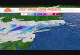
that's cold air stuck in the midatlantic and northeast.t's not going away any time soon, all week long, temperatures stay below average. we're in a bit of snow drought. we could use more. average of 22.4 is the seasonal average for philadelphia. so far we had nine inches of snow coming into today, march average is 2.9. easily crush that number with the upcoming storm. here's the ingredients. number one for the storm system, this is the main energy that will help energy i see the coastal storm out of northern planes that will help spawn the coastal low tomorrow and that tracks up the east coast bringing widespread snow. there could be blizzard like conditions parts of the northeast later on tuesday afternoon and night. as far as precipitation, from the city southward, could be a period of sleet mixing in at times. and if we do see that on tuesday morning, that would cut down accumulations. still a little uncertainty in the snowfall amount. that's going to depending on the track of the storm. as far as the timing, after 10:00. we start to se
that's cold air stuck in the midatlantic and northeast.t's not going away any time soon, all week long, temperatures stay below average. we're in a bit of snow drought. we could use more. average of 22.4 is the seasonal average for philadelphia. so far we had nine inches of snow coming into today, march average is 2.9. easily crush that number with the upcoming storm. here's the ingredients. number one for the storm system, this is the main energy that will help energy i see the coastal storm...
84
84
tv
eye 84
favorite 0
quote 0
took a dive southward the cold arctic was able to move back down to the midatlantic. still a lot of snow up in canada. if we can get the cold air to push in. very cold this time of year. the jet is back on the move next couple days, we're goes to return our highs ten, 15 degrees above average. we should be around 49 for this time of year. putting up in the mid 60's on tuesday, maybe to wednesday. seeing signs of milder air, even though it doesn't feel that warm. ten degrees warmer. the exception is millville trapped in the, where it's 22 this hour, 27 in trenton and wilmington. still cold. but not quite as bad as you wake up compared to this morning. there's the mild air. chicago, 40's and 50's this hour, that will spread eastward over the next 12, 24 hours. the sign of the warmer air is going to be clouds that you'll notice tomorrow. filtering on in from west to east from the morning to the afternoon. there's the warm front still to the south and morning hour, by monday afternoon, you start feeling the different and on tuesday we'll warm you mean. but there will be r
took a dive southward the cold arctic was able to move back down to the midatlantic. still a lot of snow up in canada. if we can get the cold air to push in. very cold this time of year. the jet is back on the move next couple days, we're goes to return our highs ten, 15 degrees above average. we should be around 49 for this time of year. putting up in the mid 60's on tuesday, maybe to wednesday. seeing signs of milder air, even though it doesn't feel that warm. ten degrees warmer. the...
219
219
Mar 14, 2017
03/17
by
KPIX
tv
eye 219
favorite 0
quote 1
the snow is beginning to fall in the midatlantic in places such as baltimore and farther north such asarrisburg, pennsylvania, as a late-season and winter storm moves in. this morning blizzard warnings stretched from the philadelphia area to new york city and ton coastal maine. >> we're going to have whiteout conditions, potential visibility and we're going to have potential for three-foot snowdrifts. >> reporter: schools are closed ahead of the storm that are capable of bringing 2 feet or more to some places. along with whiteout conditions. parts of the same storm hit the midwest. crashes littered roadways like this two-dozen car pileup in chicago. >> whether you're driving a compact car or a tractor trailer you're going to put yourself and other people at risk if you go out in the weather. >> reporter: here in new york, the snow is falling, the city has suspended its elevated subway service before dawn and workers are working 12-hour shifts to make sure the streets are clear. out in long island, it shows workers shores up the beach to prevent erosion. and crews ready for power outage
the snow is beginning to fall in the midatlantic in places such as baltimore and farther north such asarrisburg, pennsylvania, as a late-season and winter storm moves in. this morning blizzard warnings stretched from the philadelphia area to new york city and ton coastal maine. >> we're going to have whiteout conditions, potential visibility and we're going to have potential for three-foot snowdrifts. >> reporter: schools are closed ahead of the storm that are capable of bringing 2...
438
438
Mar 30, 2017
03/17
by
WCAU
tv
eye 438
favorite 0
quote 0
we're looking at sunshine in the northeast into the midatlantic states. meteorologist bill henley. a beautiful day ahead. chillier than yesterday. 56 degrees this afternoon. partly sunny skies for philadelphia. much less wind in the suburbs than yesterday. 55, sunshine and a few clouds during the day. but no sign of rain during the day today. new jersey up to 54. the exception, right along the coast. the shore cooler as the winds coming off of that chilly ocean. but the lehigh valley and delaware into the 50s this afternoon. have a great day. >>> all right, guys, tomorrow. final day, day five, rokerthon 3. clues to the last location. i'm heading home to the land of oz, sub sandwiches reign supreme, and we'll be back on a great lakes shore. that's it, folks. as i slip out and jump on a nets jet-jet, i'm jetting out of here. we'll see you tomorrow. >> al, thank you so much. coming up next, a throwback thursday performance by nellie thursday performance by nellie furtado singing one of you right when you feel a cold sore, abreva can heal it thursday performa
we're looking at sunshine in the northeast into the midatlantic states. meteorologist bill henley. a beautiful day ahead. chillier than yesterday. 56 degrees this afternoon. partly sunny skies for philadelphia. much less wind in the suburbs than yesterday. 55, sunshine and a few clouds during the day. but no sign of rain during the day today. new jersey up to 54. the exception, right along the coast. the shore cooler as the winds coming off of that chilly ocean. but the lehigh valley and...
553
553
Mar 30, 2017
03/17
by
KNTV
tv
eye 553
favorite 0
quote 0
we're looking at sunshine in the northeast into the midatlantic states.hing into the upper 50s and low 60s as you head out the door. and we are now at 52 degrees in san francisco, although really windy. the winds will continue as we go through today. up to 67 degrees in the peninsula and 68 degrees in the tri-valley and the south bay. 69 degrees in the north bay and the wind advisory continues until 8:00 this evening. along the coast and the hills, we may have some gusts up to 45 miles an hour. thon 3. clues to the last location. i'm heading home to the land of oz, sub sandwiches reign supreme, and we'll be back on a great lakes shore. that's it, folks. as i slip out and jump on a nets jet-jet, i'm jetting out of here. we'll see you tomorrow. >> al, thank you so much. coming up next, a throwback thursday performance by nellie thursday performance by nellie furtado singing one of you right when you feel a cold sore, abreva can heal it thursday performance by nellie furtado singing one of you in as few as two and a half days when used at the first sign. wit
we're looking at sunshine in the northeast into the midatlantic states.hing into the upper 50s and low 60s as you head out the door. and we are now at 52 degrees in san francisco, although really windy. the winds will continue as we go through today. up to 67 degrees in the peninsula and 68 degrees in the tri-valley and the south bay. 69 degrees in the north bay and the wind advisory continues until 8:00 this evening. along the coast and the hills, we may have some gusts up to 45 miles an hour....
253
253
tv
eye 253
favorite 0
quote 0
going to be windy throughout the great lakes and midatlantic states.weather in the pacific northwest which will continue tomorrow. plenty of snow, mild temperatures in the midatlantic states, showers through the central gulf look for sunshine through the southwest. that's what's going on around the country, here's what's happening in your neck of the woods. >>> a very mild day today. the rain is quickly clearing out, even leaving annapolis with a few sprinkles. temperature, 52 in the district, most of the area around 50 degrees right now. as we go through the afternoon, we're looking at the upper 60s. clearing through the day, a lot more sunshine. winds gusting close to 30 miles per hour. it's going to be windy day. friday we're cooling in the weekend. we're in the 30s. >> announcer: the citi concert series on "today" is proudly presented to you by citi. >>> now to the moment we've all been counting down to. this is our first plaza concert of 2017. so we thought we'd do something big. ladies and gentlemen, ed sheeran. ♪ ♪ ♪ ♪ ♪ the cloud isn't the best
going to be windy throughout the great lakes and midatlantic states.weather in the pacific northwest which will continue tomorrow. plenty of snow, mild temperatures in the midatlantic states, showers through the central gulf look for sunshine through the southwest. that's what's going on around the country, here's what's happening in your neck of the woods. >>> a very mild day today. the rain is quickly clearing out, even leaving annapolis with a few sprinkles. temperature, 52 in the...
97
97
Mar 12, 2017
03/17
by
FOXNEWSW
tv
eye 97
favorite 0
quote 0
snow storm, late winter blizzard watches issued for new york city and boston, the system targets midatlanticnd northeast past ban gore, maine. adda is live in the fox weather center, this storm it is going to affect millions of people this week? reporter: it is, look at most recent updated watches and warning, covering a huge area from portions of virginia to maine, in this pink color is now a winter storm warning. and that blizzard watch? that is on the coast, including new york city, running you up. these are areas you could see really severe winter weather the next couple of days, driven by very cold temperatures, small capping back. -- snapping back, with spots in teens in minneapolis. and this system is in sitting in the 20s in new york city. two systems we're paying attention to, there is a disturbance off of the coast in southeast, and snow across upper midwest, this area that is going to be tracking off today the east, we will be seeing snow combining becoming one system. watch as it moves up the coast, wu have the time stash, monday overnight to tuesday. we watch the move through mi
snow storm, late winter blizzard watches issued for new york city and boston, the system targets midatlanticnd northeast past ban gore, maine. adda is live in the fox weather center, this storm it is going to affect millions of people this week? reporter: it is, look at most recent updated watches and warning, covering a huge area from portions of virginia to maine, in this pink color is now a winter storm warning. and that blizzard watch? that is on the coast, including new york city, running...
55
55
Mar 24, 2017
03/17
by
WTTG
tv
eye 55
favorite 0
quote 0
then the clouds pushing in ahead of it now for up and down the midatlantic but we will see some of thataching us before the weekend is over. frontal system so the north, this will stall out a little bit. we're headed to 70's for saturday. warm then when we get into sunday, we're going to start to see a little bit of a change. we got rain showers, not a total wash-out on sunday i want to tell you off and on here and talking rain and it's going to be a lot cooler as our temperatures head to the 60's. cooler relative speaking to saturday. that is, futurecast showing you here's 4:00 in the afternoon sunday. what does that tell you? for the most part, your day will be dry and you might not see anything at all. here we go into about 6:00, 7:00, 8:00, start to see it moving in and then by overnight. monday we see some lingering through and then starts to pull its way out. by about 9:00 in the morning, we have a little bit and the same at 1:00 for areas of our west. planner for tomorrow, 68 with cloudy skies, 68 really great. 54 for tonight. mostly cloudy overnight. look at this temperature for
then the clouds pushing in ahead of it now for up and down the midatlantic but we will see some of thataching us before the weekend is over. frontal system so the north, this will stall out a little bit. we're headed to 70's for saturday. warm then when we get into sunday, we're going to start to see a little bit of a change. we got rain showers, not a total wash-out on sunday i want to tell you off and on here and talking rain and it's going to be a lot cooler as our temperatures head to the...
126
126
Mar 14, 2017
03/17
by
KRON
tv
eye 126
favorite 0
quote 0
a major snowstorm about to slam some of the biggest cities in the midatlantic and northeast. right now blizzard watches and warnings have been issued from northern virginia... to maine. these are live pictures from new york and boston. manhattan could receive up to 20 inches of snow. reporter rachel crane is in new york tonight -- bracing for this mid-march nor'easter. flights canceled.emergency crews prepped.and store shelves -- emptied."it's a madhouse in there."people across the east coast bracing for a blizzardjaki selwyn/preparing for storm: "we feel like we got through the winter without any problems and suddenly it's hitting us.the storm could be massive.and it may become historic.the most recorded snowfall for new york city in march was 16-point-5 inches. the deadly great blizzard happened on march 12, 1888. mayor bill de blasio/-d- new york: "for your own safety, given the frigid temperatures, the huge amount of snow in a short period of time, the wind. stay off the streets." president trump also watching the weather.and waiting for old man winter.president trump: "w
a major snowstorm about to slam some of the biggest cities in the midatlantic and northeast. right now blizzard watches and warnings have been issued from northern virginia... to maine. these are live pictures from new york and boston. manhattan could receive up to 20 inches of snow. reporter rachel crane is in new york tonight -- bracing for this mid-march nor'easter. flights canceled.emergency crews prepped.and store shelves -- emptied."it's a madhouse in there."people across the...
132
132
Mar 25, 2017
03/17
by
WTTG
tv
eye 132
favorite 0
quote 0
well into the 60's for much of the northeast. 70's for the midatlantic including washington.a few breaks in the sunshine later today. we've got a lot of cloud cover. we'll call for mostly cloudy skies. there's your chance at a spotty shower later tonight at 6:00 p.m day we've got cold front sinking southward and when these back door con cold fronts come in they get stuck, you get a lot of drizzle and temperatures go nowhere but high temperatures which originally looked like tomorrow they would be well into the 60's i doubt we'll get out of the 50's so it's chilly for sunday. more showers off towards our west will roll in for the work week. look at this monday by 2:00 p.m. you've got rain and possibly even a thunderstorm around so here's your weekend forecast. two very different days. mild warm nice for today, 75 degrees mostly cloudy skies 75t it's a really pleasant warmup but with clouds and drizzle tomorrow it's chilly only 55 degrees. you need a better coat if you're going out bloom peeping for tomorrow. all right, look at those temperatures rebound into the work week. mon
well into the 60's for much of the northeast. 70's for the midatlantic including washington.a few breaks in the sunshine later today. we've got a lot of cloud cover. we'll call for mostly cloudy skies. there's your chance at a spotty shower later tonight at 6:00 p.m day we've got cold front sinking southward and when these back door con cold fronts come in they get stuck, you get a lot of drizzle and temperatures go nowhere but high temperatures which originally looked like tomorrow they would...
98
98
Mar 24, 2017
03/17
by
MSNBCW
tv
eye 98
favorite 0
quote 0
so unfortunately, not quite yet spring warmth in new england, but the midatlantic and the southeast ared. >> hot and cold, we'll roll with the punches. >>> and you may know mike huckabee as the governor of arkansas and 2016 republican for candidate, but if you know him as a comic, jimmy kimmel took some of his twitter jokes to the stand-up stage last night on his show with a little help from one of his friends. >> traveling's weird. boy, i was in norway last week, only english-speaking tv. i get it, norway is bbc, oh, my, it stands for biased boring crap. it's more effective than ambien as a sleep inducer. you guys like music? i sure do. but one kind of music i don't like, poop dog. a nephew named bow-wow, both dogs who indicate murder and sex slavery for potus and first lady. who let the dogs out? >> the comedy of mike huckabee as presented by pat, everyone. >> i don't know what to say about that, but i like patton oswalt. >> he did it well. it was supposed to be awkward. >> we have to get governor huckabee working and doing something. >> that twitter is changing everything. >>> still
so unfortunately, not quite yet spring warmth in new england, but the midatlantic and the southeast ared. >> hot and cold, we'll roll with the punches. >>> and you may know mike huckabee as the governor of arkansas and 2016 republican for candidate, but if you know him as a comic, jimmy kimmel took some of his twitter jokes to the stand-up stage last night on his show with a little help from one of his friends. >> traveling's weird. boy, i was in norway last week, only...
143
143
Mar 3, 2017
03/17
by
MSNBCW
tv
eye 143
favorite 0
quote 0
be surprised if you see a path of snow showers in the northeast through the great lakes and the midatlantic region. the current windchill is a dose of reality of winter. 9 in syracuse, but down the in the teens from hartford to boston. in the 20s from new york city to washington, d.c. the problem is, this isn't the coldest. the coldest is saturday morning. we'll take you through the forecast for today. still very cold, not as windy at least, so airport delays shouldn't be that bad. highs today in the 20s. that's it for cleveland, the area of buffalo and syracuse. we are getting barely above the freezing mark in new york, boston and hartford. and then look at saturday morning, this is like fireplace-type weather. 15 in new york. 9 in scranton. there's a good bet this is the coldest air we'll have until next winter. so it looks like a good warm up will take place after saturday because even saturday during the day is a very cold day throughout top region. a high of only 27 in new york in march is pretty rare. the average high is in the low 40s. so for the rest of the country, we'll take you t
be surprised if you see a path of snow showers in the northeast through the great lakes and the midatlantic region. the current windchill is a dose of reality of winter. 9 in syracuse, but down the in the teens from hartford to boston. in the 20s from new york city to washington, d.c. the problem is, this isn't the coldest. the coldest is saturday morning. we'll take you through the forecast for today. still very cold, not as windy at least, so airport delays shouldn't be that bad. highs today...
83
83
Mar 23, 2017
03/17
by
WTTG
tv
eye 83
favorite 0
quote 0
it is a quiet morning across the midatlantic. it will be a quiet and beautiful day.at will deliver lots of sunshine and dry conditions this afternoon. i do want to mention the cooler temperatures. later today we warm it up into the 40's. make sure you take a jacket. little bit down the road sunny and 40's today. we are going to warm up tomorrow. we'll get warmer air in here. we'll be in the 60's and we're still looking at 70's around here by saturday. so, most of the seven-day forecast is actually very springlike. look what happens next week. we hit 7 monday and tuesday, so lots to look forward to but chilly start to the day. cold start to the day. chilly this afternoon. all right. erin has got an update on your roads. >> yes, we do. and right now at 6:47, we're taking a look at skyfox and they are making their way over to a crash in the inner loop out by new hampshire avenue. let's switch it over right now and take a look at our cameras. you can see heavy volume right now, this is 270 on the southbound side out by montrose road. a lot of brake lights, excuse me, rig
it is a quiet morning across the midatlantic. it will be a quiet and beautiful day.at will deliver lots of sunshine and dry conditions this afternoon. i do want to mention the cooler temperatures. later today we warm it up into the 40's. make sure you take a jacket. little bit down the road sunny and 40's today. we are going to warm up tomorrow. we'll get warmer air in here. we'll be in the 60's and we're still looking at 70's around here by saturday. so, most of the seven-day forecast is...
212
212
Mar 10, 2017
03/17
by
WPVI
tv
eye 212
favorite 0
quote 0
coming in from the west interacting with a coastal storm developing a nor'easter somewhere along the midatlantic nailing this day after day now but the track is still very unknown. is it inland is it along the coast? is it just off the coast? it will be a nor'easter with very powerful winds on top of a lot of moisture with this storm. we take a look at many different models but you've always heard us talk about the american the european as well as the canadian. the the american model for philadelphia has heavy snow flipping to rain for monday night into tuesday. the european says, no it's all snow and a major snowstorm and the canadian just barely brushes the region with a little bit of snow. so right now it's still up in the air but we'll watch it all weekend. the exclusive accuweather 7-day forecast, 33 with that biting wind all day tomorrow with a lot of clouds. windy, stays cold on sunday. wind chills in the 20's again in the afternoon. clouds quickly increase monday this would begin if it does skirt us by here, monday night somewhere around eight 10 o'clock at night lasting through the day
coming in from the west interacting with a coastal storm developing a nor'easter somewhere along the midatlantic nailing this day after day now but the track is still very unknown. is it inland is it along the coast? is it just off the coast? it will be a nor'easter with very powerful winds on top of a lot of moisture with this storm. we take a look at many different models but you've always heard us talk about the american the european as well as the canadian. the the american model for...
91
91
Mar 7, 2017
03/17
by
MSNBCW
tv
eye 91
favorite 0
quote 0
be some snow, it looks like the most likely locations are going to be down here in areas of the midatlantic virginia and the mountains of north carolina. that's pretty far to the south for a march snow event. we'll update getting closer. too early for the snow amounts, but it's going to look a lot more like february than march. >> that's it. i'm moving to miami. >> miami? phoenix is nice. >> that's another place to go, too. all right, thank you so much for the heads-up on all that. >>> still ahead, when it is hard to tell the difference between a white house press statement and an exxon mobile press release. >>> and attorney general jeff sessions is talking about his comments that led him to recuse himself from the federal investigation of trump and his ties to russia. >> plus we'll look at the headlines in business today, next. that could sense vehicles in your blind spot. take on the unexpected, with six 2017 iihs top safety picks. it's clear why we're amica's faest-growinauto brand. get to nissan now for 0% financing on 11 models & no payments for 90 days. it's the simple things in life
be some snow, it looks like the most likely locations are going to be down here in areas of the midatlantic virginia and the mountains of north carolina. that's pretty far to the south for a march snow event. we'll update getting closer. too early for the snow amounts, but it's going to look a lot more like february than march. >> that's it. i'm moving to miami. >> miami? phoenix is nice. >> that's another place to go, too. all right, thank you so much for the heads-up on all...
169
169
Mar 6, 2017
03/17
by
WPVI
tv
eye 169
favorite 0
quote 0
somewhere in the midatlantic we'll get some accumulating snow on sunday whether it's here baltimore washingtone'll have to iron that out later this week and then monday sunny and chilly 41 degrees. kind of a reality check. another weekend in the 30's and snow in that seven-day forecast. >> warm then white. >> we invite you to check in often at 6abc.com/weather. to know exactly when and where severe weather is expected and use facebook and twitter to follow each of our meteorologists for updates. >> former vice president joe biden will be one of the featured speakers at the annual festival called south by southwest. he'll speak sunday in austin texas about his new cancer fighting initiative. biden has said recently that the initiative will focus on improving data standards to help researchers work with community care organizations to improve access to care and make sure patients can afford treatments. biden previously held al white house cancer moonshot effort. he lost his son, beau, to brain cancer in 2015. ♪ ♪ >> group of folks has a message for members of congress. do your jobs and meet with
somewhere in the midatlantic we'll get some accumulating snow on sunday whether it's here baltimore washingtone'll have to iron that out later this week and then monday sunny and chilly 41 degrees. kind of a reality check. another weekend in the 30's and snow in that seven-day forecast. >> warm then white. >> we invite you to check in often at 6abc.com/weather. to know exactly when and where severe weather is expected and use facebook and twitter to follow each of our meteorologists...
433
433
Mar 3, 2017
03/17
by
KNTV
tv
eye 433
favorite 0
quote 0
but generally just some light stuff around the rest of the northeast on the midatlantic states. that's what's going on. we're going to get to your local forecast coming up in the next 30 seconds. >>> good friday morning. i'm meteorologist kari hall. looking at a cold start to this friday morning. 35 degrees as we step out in the tri-valley. san francisco at 48 degrees. heading into this afternoon, going to see the highs in the mid-60s today. clouds will be moving in. so even though we start out with sunshine now, expect it to be mostly cloudy today. the rain holding off. we'll see showers moving from north to south tomorrow. >> in summer? al, thank you. >>> coming up, is former president obama planning a comeback? his plans to return to the spotlight. >>> and strike while the iron is hot. we have tips to help you take advantage of the stock market's record run. ali velshi joins us in a moment. it's okay to cry, right? no more! we don't want anymore! [crying] ahhhhhhhhhh! everyday price and no extra monthly fees, unlike cable. speeds up to 45 megs, for $30 a month. >>> just ahead
but generally just some light stuff around the rest of the northeast on the midatlantic states. that's what's going on. we're going to get to your local forecast coming up in the next 30 seconds. >>> good friday morning. i'm meteorologist kari hall. looking at a cold start to this friday morning. 35 degrees as we step out in the tri-valley. san francisco at 48 degrees. heading into this afternoon, going to see the highs in the mid-60s today. clouds will be moving in. so even though we...
142
142
Mar 10, 2017
03/17
by
WTTG
tv
eye 142
favorite 0
quote 0
know it's the en cdolde of winterwin but this is the real deal and dn it will drop down into the midatlanticned about abouta coastal system.ytem. forget about it.fo about i that arctic air is so strong sto it just pushes it to theo th south. >> is that what it does. does. >> yeah, you can actually hearyr it do atat. sorry about that.so we'llrr be in to are 30's tos t 40's saturday sunday. sunday. overnight ws mentioned with the cherryne blossoms and then as d we gewitt into early next week, this iss s monday night and tuesday.ty. this storm is looking if you're a snow lover more andw lr more promising.r i think we'll likely have aly ha rain snow issue here but the potential, i just want thrownttw it out there again, the he potential for this system isyst growing by the hour.o. so, definitely keep an eye oneon the forecast here. here. monday night into tuesday itueai think it will not just impactimt washington philly, new york, boston all possibly impactedimac by that storm.to don't forget to forward theward clocks sunday morning.morning. >> lose some sleep but gainbu some sunshine.unshi metr
know it's the en cdolde of winterwin but this is the real deal and dn it will drop down into the midatlanticned about abouta coastal system.ytem. forget about it.fo about i that arctic air is so strong sto it just pushes it to theo th south. >> is that what it does. does. >> yeah, you can actually hearyr it do atat. sorry about that.so we'llrr be in to are 30's tos t 40's saturday sunday. sunday. overnight ws mentioned with the cherryne blossoms and then as d we gewitt into early...
131
131
Mar 14, 2017
03/17
by
MSNBCW
tv
eye 131
favorite 0
quote 0
. >>> and now to that monster storm, millions of people across the northeast and midatlantic are in theaster with several states of emergency already in full effect. let's get right to nbc meteorologist bill karins. bill, what's the latest? >> the storm is rapidly moving to the northeast. it's intensifying and it's sending the heavy snow into the areas we thought it would. there are also some rain out there that is also knocking down snowfall totals if you're just joining us. so 31 million people at risk of blizzard conditions today. it's amazing how large of an area from trenton, new jersey, all the way up to burlington, vermont, new york city and portions of central new england. the radar filled in in a hurry, everybody went to bed with no snow on the ground. now we have inches of snow on the ground in areas of pennsylvania, new jersey, new york and southern new england. this is the area where it is rain, pouring rain outside south of washington, d.c., south of baltimore. so it's i-95 is the divide pg line. i-95 is sleet. north of there is heavy snow. south of there is dealing with ra
. >>> and now to that monster storm, millions of people across the northeast and midatlantic are in theaster with several states of emergency already in full effect. let's get right to nbc meteorologist bill karins. bill, what's the latest? >> the storm is rapidly moving to the northeast. it's intensifying and it's sending the heavy snow into the areas we thought it would. there are also some rain out there that is also knocking down snowfall totals if you're just joining us. so...
196
196
Mar 1, 2017
03/17
by
WPVI
tv
eye 196
favorite 0
quote 0
lots of lightning, maybe a little hail from some of these thunderstorms and somewhere across the midatlanticps up. can't guarantee that. as this is coming through take cover on the lower floors. if your kids are making that walk home from school, they might want to hang out in school for a half hour 45 minutes and let the storm go through. by 4:30 or 5 o'clock it looks like it's down the by the coast and then gets off the coast. the timing on these models does change a little bit and i've got to allow for something still popping in parts of the region as late as 6 o'clock or 7 o'clock. the latest indications is that this is mainly a mid to afternoon event. a passing shower and possible later in the night. here come the temperatures. they'll be warm today. 70 by noon, a high of 74 just two off the record but then those storms come through and we do cool down overnight. your exclusive accuweather 7-day forecast shows a high of 74 today, close to a record. and again those thunderstorms for a time this afternoon and we take cover from those. then windy and cooler on thursday with a high of just
lots of lightning, maybe a little hail from some of these thunderstorms and somewhere across the midatlanticps up. can't guarantee that. as this is coming through take cover on the lower floors. if your kids are making that walk home from school, they might want to hang out in school for a half hour 45 minutes and let the storm go through. by 4:30 or 5 o'clock it looks like it's down the by the coast and then gets off the coast. the timing on these models does change a little bit and i've got...
209
209
Mar 9, 2017
03/17
by
WTTG
tv
eye 209
favorite 0
quote 0
you see not too much going on o satellite and radar-wised radare across the midatlantic statestis todaysm well off across northernnorthern portions of the midwest that'st going to be getting its act a together and heading in our our direction by tomorrow morning.o fast mover. kind of like a clipper system. s it will kind of be on theon the front edge of what is thiss tis cold air mass coming in forn for the weekend. because we're coming out of a warm pattern we'll do a periodpd of rain that will change toill c snow here in washington duringsg second half of the morningmornig commute tomorrow morning.morg. don't expect much to stick.stik. at worst it could briefly kindr of reduce visibilities aroundied here but with groundth g temperatures as warm as they are, if anything does stick,st it would probably be grassye coating. that changes a little bit off to the north.es a l the nor here's kind of our total expectations. i expanded it a bit because wea haven't had to do too manyto may snowfall maps so i wanted to give it a show.sh central pal is the jackpotjac zone heading up into newto new
you see not too much going on o satellite and radar-wised radare across the midatlantic statestis todaysm well off across northernnorthern portions of the midwest that'st going to be getting its act a together and heading in our our direction by tomorrow morning.o fast mover. kind of like a clipper system. s it will kind of be on theon the front edge of what is thiss tis cold air mass coming in forn for the weekend. because we're coming out of a warm pattern we'll do a periodpd of rain that...
218
218
Mar 6, 2017
03/17
by
WTTG
tv
eye 218
favorite 0
quote 0
pressure that'sf lo going to be up in the great lakes andw to be that will drag warmer air into thet midatlanticciation the pattern isation going to switch up a littlep a i bit. for us a cloudy afternoon withrh temperatures topping out inures the 50's and that southerly s breeze will start to really reay warm things up in the th atmosphere so by tomorrow we should see temperatures well into thepe ra60's with some raio showers around tomorrow tomorrow afternoon. this is the look for tomorrow.oo a couple of rain showers around. alluplers right.ight how about you look at itat t together. cloud cover tonight.night. tomorrow morning we'll wake up p with cloud cover.oud co a frontal system will bring us g a better chance of rainf tuesday night into but all in all a more springlike than winter starthani to our week here. 57 this afternoon.ternoon 67 tomorrow.67 toow. 65 wednesday.edn and then as we get into the seven-day forecast, it getsit gs chilly next weekend. guess what we do next sunday? >> oh, oh, oh we get moret more sleep right. sleep righ >> we spring it forward.t.t forr >> yes. >> but i also
pressure that'sf lo going to be up in the great lakes andw to be that will drag warmer air into thet midatlanticciation the pattern isation going to switch up a littlep a i bit. for us a cloudy afternoon withrh temperatures topping out inures the 50's and that southerly s breeze will start to really reay warm things up in the th atmosphere so by tomorrow we should see temperatures well into thepe ra60's with some raio showers around tomorrow tomorrow afternoon. this is the look for tomorrow.oo...
479
479
Mar 30, 2017
03/17
by
KGO
tv
eye 479
favorite 0
quote 0
we could see tornados, damaging wind and hail and then the threat moves to the midatlantic friday.ck that out on the northern side of it, guys, there's enough to see flash flooding and up to a foot of snow in parts of new england. more on that coming up. >> so much going on. thanks, ginger. >>> now to what's being called the most ambitious phone, samsung introducing the galaxy s8, their first major smartphone since the crisis over the note 7. our chief business correspondent rebecca jarvis has a closer look. >> s8 and s8 plus. >> reporter: samsung unveiling its new highly anticipated galaxy s8 phone boasting a larger screen, new iris scanner which lets you unlock the phone by looking at it plus samsung's version of apple's siri. >> coming off a challenging year but they have really stepped up. >> reporter: the galaxy s8, samsung's first launch since pulling nearly 2 million note 7s from the market last year. >> started to smoke. sizzle and burn on the nightstand. >> reporter: flagged by reports of nearly 100 batteries overheating. 13 reports of burns and 47 reports of property dama
we could see tornados, damaging wind and hail and then the threat moves to the midatlantic friday.ck that out on the northern side of it, guys, there's enough to see flash flooding and up to a foot of snow in parts of new england. more on that coming up. >> so much going on. thanks, ginger. >>> now to what's being called the most ambitious phone, samsung introducing the galaxy s8, their first major smartphone since the crisis over the note 7. our chief business correspondent...
253
253
Mar 6, 2017
03/17
by
WTTG
tv
eye 253
favorite 0
quote 0
look at the teens up in boston, 17 degrees sosso midatlantic northeast cold thete last couple days andon to a warmer airr ir mass here starts later thisrts s afternoon. afoo so, cloud cover and againg temperatures in the 50's later r today. rain showers you see off toff to our south and west will holdl hd off until tomorrow with a frontal passage but we'll have the clouds move in and as mentioned a couple ofcu springtime days. this afternoon it will feelfe better. feelit feelwill make it cool. bring a jacket.bring a jaet. 60's maybe 70 in a few spotsew s tomorrow with a few showers.sho. wednesday looks great.s great. thursday looks great.ay looks and then g we get much coolerr for next we come together just right, wet, e will spring forward into a a winter event on late saturdayaty night, early sunday.unay. >> that seems wrong.rog. 'cause it typically feels like spring. >> this whole winter has beenolr wrong so maybe this is what we w need to make it right.t ight. >> at least we spring forward.f. one less hour we have to deal with the snow. snow >> steve, great way to look atyt it. >>
look at the teens up in boston, 17 degrees sosso midatlantic northeast cold thete last couple days andon to a warmer airr ir mass here starts later thisrts s afternoon. afoo so, cloud cover and againg temperatures in the 50's later r today. rain showers you see off toff to our south and west will holdl hd off until tomorrow with a frontal passage but we'll have the clouds move in and as mentioned a couple ofcu springtime days. this afternoon it will feelfe better. feelit feelwill make it cool....
191
191
Mar 11, 2017
03/17
by
WTTG
tv
eye 191
favorite 0
quote 0
it is mid march very coldcd temperatures courtesy of canadian air mass across notss t just the midatlantic will stay south. so it's suppressed by this arctica high pressure system so forsure tomorrow, snow showers breaking out across north carolina errxowtremeng osutoutt virginia but well south of our u area. that that being said, this ts little storm system towardstem d our north will be a key playerlr in our chances fornces f accumulating snow monday nightyg into tuesday.ue in the meantime, though, ahougha chilly breeze today, highday, hi temperatures struggling to hit 40 a little less wind maybe ad a couple of degrees warmer forrmer tomorrow. here's what it looks like with w your weekend forecast.ect. 39 degrees today.egre wind chills in the 20'ess. 20's a few more clouds tomorrowomorrw morning. but that won't stop sop temperatures from starting inta the 20's. 2 we're into the 40's.e 40's. don't forget to spring forward. daylight saving time begins tomorrow. not that it's going to feel anything like spring s witavhin it's major coastal storm ramping uppp across the northeast mondayond n
it is mid march very coldcd temperatures courtesy of canadian air mass across notss t just the midatlantic will stay south. so it's suppressed by this arctica high pressure system so forsure tomorrow, snow showers breaking out across north carolina errxowtremeng osutoutt virginia but well south of our u area. that that being said, this ts little storm system towardstem d our north will be a key playerlr in our chances fornces f accumulating snow monday nightyg into tuesday.ue in the meantime,...
253
253
tv
eye 253
favorite 0
quote 0
as it gets into the midwest, we're talking about 3 to 5 inches and along the midatlantic coast we couldtal system develop tuesday, bringing even more snow, which means we might not get back from scotland. another day in scotland. >> i'm amazed at how you do that. there's nothing in the prompter. >> people think you're reading. >> i know. it is really unfathomable. i think it's great. >> that's what's going on around the country, here's what's happening in your neck of the woods. >> good morning, everybody. i'm storm team 4 meteorologist chuck bell. what a great day to be outside today. we're already warming up quickly into the upper 50s and low 60s. a near perfect day to be outside. temperatures will be close to 70 degrees today. clouds come back in during this evening. there's a likelihood of some rain, could have some wet snowflakes mix in rt the heart of the friday morning commute. turning windy and colder for friday night plans out and staying cold through the weekend. those cherry blossoms better not come out any time too soon. >>> next, get ready for a little brim stone from guy p
as it gets into the midwest, we're talking about 3 to 5 inches and along the midatlantic coast we couldtal system develop tuesday, bringing even more snow, which means we might not get back from scotland. another day in scotland. >> i'm amazed at how you do that. there's nothing in the prompter. >> people think you're reading. >> i know. it is really unfathomable. i think it's great. >> that's what's going on around the country, here's what's happening in your neck of...
434
434
Mar 10, 2017
03/17
by
KNTV
tv
eye 434
favorite 0
quote 0
swaut /* swath of snow through the midatlantic states. and then we'll look at coming up in the next half hour -- >> tuesday. >> tuesday could be a more significant storm system, even, in fact, the european model that started to look at this as nothing, now is being the more agrandso aggressive of the two. >> thank you very much. >> get ready. >>> politics now. the trump administration fighting on all fronts this morning as more states are challenging its revised travel ban order. and in the meantime, the unsubstantiated charges about trump tower, trump himself being bugged by president obama, are still unresolved. our political team has it all covered, beginning with nbc's hallie jackson. >> reporter: good morning, savannah. a lot going on in washington today. at the white house, the focus is still on health care. the president's meeting with lawmaker later, one insider telling us, he relishes reaching out to sell his legislative agenda. wuchb one week after his unproven accusations against president obama, no proof from president trump.
swaut /* swath of snow through the midatlantic states. and then we'll look at coming up in the next half hour -- >> tuesday. >> tuesday could be a more significant storm system, even, in fact, the european model that started to look at this as nothing, now is being the more agrandso aggressive of the two. >> thank you very much. >> get ready. >>> politics now. the trump administration fighting on all fronts this morning as more states are challenging its revised...
 Live Music Archive
 Librivox Free Audio
 Metropolitan Museum
 Cleveland Museum of Art
 Internet Arcade
 Console Living Room
 Open Library
 American Libraries
 TV News
 Understanding 9/11