254
254
Oct 10, 2012
10/12
by
KGO
tv
eye 254
favorite 0
quote 0
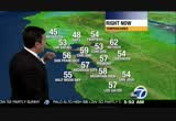
down to the monterey bay you can see a better chance of thunderstorms around here, temperatures in the low to mid 60s bay upper 60s to 70 inland. dry, still cooler than average tomorrow, isolated shower possible friday less than a chance we've had the last couple of days. warming trend begins saturday. >>> good morning. light situation san mateo bridge no problems in either direction. highrise towards foster city everything is at the limit at the san mateo bridge between the peninsula and east bay. macarthur maze light, everything flowing from 880, 580 into the bay bridge and 80 east shore freeway. little bit of bunching up out of antioch speeds at the limit towards pittsburg and concord under 20 minutes. out of the central valley, a little slow from 205 speeds pick up over the altamont pass into the dublin-pleasanton area, 15 minute drive there. >>> a dog is stolen during a burglary. a 5-year-old's plea for its safe return. >>> an 8-year-old decides to go for a late night joyride that didn't end well. >>> missing yosemite park worker rescued. the question searchers have for her. >>> f
down to the monterey bay you can see a better chance of thunderstorms around here, temperatures in the low to mid 60s bay upper 60s to 70 inland. dry, still cooler than average tomorrow, isolated shower possible friday less than a chance we've had the last couple of days. warming trend begins saturday. >>> good morning. light situation san mateo bridge no problems in either direction. highrise towards foster city everything is at the limit at the san mateo bridge between the peninsula...
185
185
Oct 10, 2012
10/12
by
KGO
tv
eye 185
favorite 0
quote 0
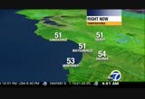
mid to upper 50s monterey bay and inland. n will scatter showers around mainly south bay and southward today thunder possible another chance of showers thursday, friday, weak chances like now warming trend this weekend drier then and quieter. area of low pressure has legs even though it is sliding south that counterclockwise flow will rotate a few more storms our way. let's put a timing on it and a -- you can see down to the south, rotating up to the north, falling apart by noon. by 4:00, start to develop an little more intensity once we get the daylight and unsettled weather moving in heading towards the santa cruz mountains and higher elevations around the santa clara valley. overnight dissipate and then snow in the sierra around yosemite above 8,000 feet tomorrow. heading to the game at the coliseum partly cloudy 6:37 first pitch grab a coat or sweatshirt, 60 61 dropping to 57. thursday, friday unsettled below average saturday drier, sunday through tuesday back to average if not slightly warmer. >>> headed to the game this
mid to upper 50s monterey bay and inland. n will scatter showers around mainly south bay and southward today thunder possible another chance of showers thursday, friday, weak chances like now warming trend this weekend drier then and quieter. area of low pressure has legs even though it is sliding south that counterclockwise flow will rotate a few more storms our way. let's put a timing on it and a -- you can see down to the south, rotating up to the north, falling apart by noon. by 4:00, start...
184
184
tv
eye 184
favorite 0
quote 0
showers possible south of the bay area monterey bay and south tuesday and wednesday. concord, oakland, san jose three degrees cooler, we lose another two minutes and 22 seconds of sun today. upper 60s to low 70s south bay, 70 redwood city and loss -- los altos many low 60s coast, light breeze and sunshine low to mid 60s downtown south san francisco and sausalito. low 60s at beaches. mainly mid to upper 60s east bay shore fremont 70 inland low to mid 70s warmest east bay valleys. monterey bay mid to upper 60s. tonight more 40s around napa, santa rosa, cloverdale. half moon bay 50. rest of us in the low to mid 50s. area of low pressure off the coast bringing chance of shower to our south and coolest arounds tuesday and wednesday, slight warming trend thursday better warming trend saturday, sunday. >>> good morning. if your drive takes you through the waldo tunnel to the golden gate bridge light all four lanes configured no problem fog-free as well no drizzle on the road. same with the san mateo bridge, clear you will fan a little heavier traffic westbound towards the hi
showers possible south of the bay area monterey bay and south tuesday and wednesday. concord, oakland, san jose three degrees cooler, we lose another two minutes and 22 seconds of sun today. upper 60s to low 70s south bay, 70 redwood city and loss -- los altos many low 60s coast, light breeze and sunshine low to mid 60s downtown south san francisco and sausalito. low 60s at beaches. mainly mid to upper 60s east bay shore fremont 70 inland low to mid 70s warmest east bay valleys. monterey bay...
298
298
tv
eye 298
favorite 0
quote 0
monterey bay mid to upper 60s. t 40s north bay everybody else in the 50s and a little more cloud cover tomorrow morning. we have area of low pressure to our west, a little drizzle for the coast as we head towards tomorrow morning. tomorrow afternoon maybe a stray shower across north bay wednesday best chance of showers down to the south. coolest tuesday, wednesday, much warmer as we head towards saturday and sunday. . a little cooler trend thursday into friday then warming trend for saturday and sunday. here's sue. >>> good morning. nice traffic headed northbound 87, drive past hp pavillion in san jose at the limit. bunching up 80 westbound towards macarthur maze, slow traffic no major stalls or accidents. slow traffic into the bay bridge toll, no metering lights starting to slow up. connector between 280 and 101 earlier two accidents now cleared. speeds picked up. both ramps open. south 101 before whipple injury accident fire on scene, police on scene, slow traffic approaching redwood city. south 880 near montague
monterey bay mid to upper 60s. t 40s north bay everybody else in the 50s and a little more cloud cover tomorrow morning. we have area of low pressure to our west, a little drizzle for the coast as we head towards tomorrow morning. tomorrow afternoon maybe a stray shower across north bay wednesday best chance of showers down to the south. coolest tuesday, wednesday, much warmer as we head towards saturday and sunday. . a little cooler trend thursday into friday then warming trend for saturday...
275
275
tv
eye 275
favorite 0
quote 0
monterey bay mid to upper 60s.ame three tonight at coliseum tigers and a's 6:00, 62°, a few clouds, cool by the end of the game down to about 57°. temperatures tonight the same ballpark as this morning 40s mainly north bay valleys. rest of us in the low to 50s. watching this area of low pressure kind of hugged the coaste#lá overnight now moving down to the south doesn't have much moisture with it. you can see with counterclockwise flow what moisture it has will wrap towards the bay area mainly stay over the coast today. tonight, a few clouds. down south of the monterey bay tomorrow where the showers will kick up, could get as far north as higher elevations around the santa clara valley. very isolated. the big story tomorrow, the coolest afternoon in the forecast along with thursday. friday slight chance of a shower then warming trend back to average sunday, monday. not too late to win $49,000 from abc 7 these people want the chance: that i all ended. the winner will be an after the 49ers game on abc 7, you can ente
monterey bay mid to upper 60s.ame three tonight at coliseum tigers and a's 6:00, 62°, a few clouds, cool by the end of the game down to about 57°. temperatures tonight the same ballpark as this morning 40s mainly north bay valleys. rest of us in the low to 50s. watching this area of low pressure kind of hugged the coaste#lá overnight now moving down to the south doesn't have much moisture with it. you can see with counterclockwise flow what moisture it has will wrap towards the bay area...
213
213
tv
eye 213
favorite 0
quote 0
next three days chance of showers mainly to the south around monterey bay and south tuesday and wednesday. thursday start to see maybe a very tiny warming trend in the 70s across the board along our inland neighborhoods. 60s bay, 50s coast. >>> good morning. good ride so far, live shot of the golden gate bridge no roadwork this morning configured now three lanes south, two lanes north they will change that when the commute gets underway fully. highway 4 westbound at somersville debris in lanes. eastbound 4 between bailey and railroad avenue most of the day until 1:00 this afternoon, expecting roadwork there as well. our waze app, a map showing pleasant hill road heading to highway 24. last night we had a fatal accident and wires are down in the road pleasant hill before 24 until 6:00 before they think to have that cleaned up. you want to take taylor east to 680 to get back to highway 24 if you would like to download this free app, join other traffic spotters, abc7news.com/waze. >> 4:41. >> meningitis scare continues to grow, the california clinics linked to the crisis. >>> generous recycl
next three days chance of showers mainly to the south around monterey bay and south tuesday and wednesday. thursday start to see maybe a very tiny warming trend in the 70s across the board along our inland neighborhoods. 60s bay, 50s coast. >>> good morning. good ride so far, live shot of the golden gate bridge no roadwork this morning configured now three lanes south, two lanes north they will change that when the commute gets underway fully. highway 4 westbound at somersville debris...
303
303
tv
eye 303
favorite 0
quote 0
the next three days chances of showers south bay monterey bay tomorrow cool and dry thursday another light shower chance friday. >>> good morning. happy tuesday. live look at 80 berkeley past ashby and university into the macarthur maze light traffic. same with the bay bridge toll, everything is smooth sailing into san francisco, no metering lights. westbound tonight highway 4 full closure for morrical trance work from 11:00 tonight to 12:30 tomorrow morning. right now out of antioch towards pittsburg westbound looking good. slow out of the central valley still good speeds towards the altamont up and over into the livermore and dublin pleasanton area. drive time of less than 15 minutes. we've been waiting the a's game tonight 6:07 coliseum, expect delays 880, 580, great to take bart. >>> arsonist on the loose in the south bay. what he's targeting and why firefighters want him off the streets, fast. >>> sexual assault on a park trail has joggers and hikers on edge. >>> first, this morning's tech bites. >>> you will be able to order the first windows 8 phones later this month. the verge
the next three days chances of showers south bay monterey bay tomorrow cool and dry thursday another light shower chance friday. >>> good morning. happy tuesday. live look at 80 berkeley past ashby and university into the macarthur maze light traffic. same with the bay bridge toll, everything is smooth sailing into san francisco, no metering lights. westbound tonight highway 4 full closure for morrical trance work from 11:00 tonight to 12:30 tomorrow morning. right now out of antioch...
323
323
tv
eye 323
favorite 0
quote 0
monterey bay mix of clouds and sun and mid to upper 60s.und the state hottest weather palm springs 94. san diego 72, l.a. 78, 65 in tahoe. back home for tonight a few more clouds than this morning, partly cloudy, 40s in the north bay valleys, low to mid 50s for the rest of us. as we wake up tomorrow morning cloud cover any shower activity will be over the coast mainly where going to stay until possibly northern sections of sonoma county may have a stray shower. towards the evening and overnight it fall as part and a better chance wednesday afternoon, well south of the monterey bay. for us, most of us outside of stray shower cooler tomorrow and wednesday. slow warming trend thursday and friday. better warming trend temperatures closer to average into saturday and sunday. i wouldn't look for measurable rain tomorrow or wednesday. it is not too late to win $49,000 from abc7. these people are taking the chance: they've all ended through our facebook page the winner will be announced after the 49ers game here october 18th. you can enter too go
monterey bay mix of clouds and sun and mid to upper 60s.und the state hottest weather palm springs 94. san diego 72, l.a. 78, 65 in tahoe. back home for tonight a few more clouds than this morning, partly cloudy, 40s in the north bay valleys, low to mid 50s for the rest of us. as we wake up tomorrow morning cloud cover any shower activity will be over the coast mainly where going to stay until possibly northern sections of sonoma county may have a stray shower. towards the evening and overnight...
260
260
Oct 29, 2012
10/12
by
KGO
tv
eye 260
favorite 0
quote 0
right now 46 in santa rosa, everybody else in the 50s, monterey bay low to mid 50s. recap of our forecast, slower cooling today, slow clearing and cooler, sunshine around the bay and inland by noon mainly cloudy at coast. cooling trend through thursday rain likely for halloween temperatures from the 60s coast in san francisco 70s for the rest of us. steady rain start moves into the north bay during the afternoon wednesday where you are going to find the wet weather for trick-or-treating. the rest of us sprinkles, possibly drizzle for wednesday evening. starting around midnight through thursday morning that's when the best chance of the rest of us outside of the north bay of getting that steadier rain friday, saturday, sunday gone and the warming trend begins. north bay is going to have the toughest time trick-or-treating. >>> fog is a fact for for your monday morning commute, thick, heavy in spots, comes up quick looking good san mateo bridge you can see brake lights over the highrise, 17 to 20 minute drive from hayward towards foster city now. hayward directionsw mod
right now 46 in santa rosa, everybody else in the 50s, monterey bay low to mid 50s. recap of our forecast, slower cooling today, slow clearing and cooler, sunshine around the bay and inland by noon mainly cloudy at coast. cooling trend through thursday rain likely for halloween temperatures from the 60s coast in san francisco 70s for the rest of us. steady rain start moves into the north bay during the afternoon wednesday where you are going to find the wet weather for trick-or-treating. the...
220
220
tv
eye 220
favorite 0
quote 0
everybody else in the 60s napa, santa rosa and half moon bay low to mid 50s, mid to upper 50s monterey bayord heat breaks today, clouds will return to the bay and coast, cooler more comfortable, better sleeping weather tonight, it will like fall this weekend what a swing, almost 30° between record highs and this what we are going to have this weekend. yesterday a few record highs where the asterisk is. today 10 degrees cooler in concord, san jose, 16 santa rosa, 19° cooler this afternoon in san francisco. the reason why, high pressure split by this low, like a battering ram coming through. pushing the high pressure and heat away from us. the pattern starts breaking today. this morning no cloud cover out there to speak of. as we head towards 1:00 sea breeze kicks in, clouds not far behind, temperatures falling this afternoon at the coast falling late this afternoon around the bay. before anyone mid to upper 80s in the south bay. low to mid 80s most of the peninsula, upper 60s to low 70s at the coast cool afternoon mid to upper 70s downtown south san francisco and sausalito low to mid 80s no
everybody else in the 60s napa, santa rosa and half moon bay low to mid 50s, mid to upper 50s monterey bayord heat breaks today, clouds will return to the bay and coast, cooler more comfortable, better sleeping weather tonight, it will like fall this weekend what a swing, almost 30° between record highs and this what we are going to have this weekend. yesterday a few record highs where the asterisk is. today 10 degrees cooler in concord, san jose, 16 santa rosa, 19° cooler this afternoon in...
183
183
Oct 23, 2012
10/12
by
KGO
tv
eye 183
favorite 0
quote 0
you can see the rest of area starting to get quiet, we still have storms following around the monterey bayand southern sections of the santa clara valley around san tar mean and morgan hill all -- san martine and metering lights hill. 47 santa rosa, 48 half moon bay rest of us low to mid 50s, low to mid 50s monterey bay you want wet weather gear handy, showers still possible just less likely than what we had yesterday better chance tonight through tomorrow of another round of pretty healthy showers. warming trend still slated for the weekend that hasn't changed in the forecast. today compared to average anywhere from seven degrees cooler in oakland eight in san francisco 10 to 13 redwood city, concord, san jose napa, most temperatures low to mid 60s showers widely scatter same around monterey bay low 60s there low to mid 60s inland tonight the green comes back wave pushing through overnight we'll wake to ponding on the roads tomorrow maybe a little hail out of these storms we are now in the cold area, colder air sliding in on this 110 mile per hour jet stream going to scatter showers into
you can see the rest of area starting to get quiet, we still have storms following around the monterey bayand southern sections of the santa clara valley around san tar mean and morgan hill all -- san martine and metering lights hill. 47 santa rosa, 48 half moon bay rest of us low to mid 50s, low to mid 50s monterey bay you want wet weather gear handy, showers still possible just less likely than what we had yesterday better chance tonight through tomorrow of another round of pretty healthy...
254
254
Oct 9, 2012
10/12
by
KOFY
tv
eye 254
favorite 0
quote 0
another chance mainly south of monterey bay tomorrow.ming trend, starts saturday as far as what is happening outside now we have temperatures that in the 60s, going to jump into the low to mid 70s in most of the south bay, upper 60s sunnyvale and milpitas. peninsula mid to upper 60s, low to mid 60s along the coast into downtown south san francisco and even sausalito. through the north bay valleys, upper 60s to low 70s there low 60s along the coast. east bay shore mid to upr 60s, union city, fremont, castro valley and hercules 70 to 71 widespread low to mid 70s east bay valleys. montereybay mid to upper 60s. ga thre tonig atolise gers and a's 6:0, 62°a few clouds, ol by the end of the game down to about 57°. temperatures tonight the same ballpark as this morning 40s mainly north bay valleys. rest of us in the low to 50s. watching this area of low pressure kind of hugged the coaste#lá overnight now moving down to the south doesn't have much moisture with it. you can see with counterclockwise flow what moisture it has will wrap towards the
another chance mainly south of monterey bay tomorrow.ming trend, starts saturday as far as what is happening outside now we have temperatures that in the 60s, going to jump into the low to mid 70s in most of the south bay, upper 60s sunnyvale and milpitas. peninsula mid to upper 60s, low to mid 60s along the coast into downtown south san francisco and even sausalito. through the north bay valleys, upper 60s to low 70s there low 60s along the coast. east bay shore mid to upr 60s, union city,...
225
225
Oct 10, 2012
10/12
by
KGO
tv
eye 225
favorite 0
quote 0
batch of thunderstorms going to continue to rotate in a counterclockwise fashion through salinas, monterey bay into the south bay. best chance of thunderstorms down there as we head into the afternoon. 60s and 70s unsettled continues thursday, friday before warming and drying forecast saturday and sunday. >>> problem bay bridge motorcycle down treasure island lane two metering lights on traffic just jammed bumper-to-bumper on the bay bridge what it is going to be. carpool lanes whizing through nicely. bart would be a good alternative. north 85 ram top northbound 17 in san jose accident there. -- bart on time capital corridor train cancelled 5:20, 5:22 will be the next train to take. >>> this morning san francisco's first target store will open. mayor lee helped celebrate the new store last night it is called city target and takes up the entire second floor of the metreon building. it is different from other target stores it won't sell bulky items. city target is tailored to urban customers with small living spaces it will open at 7 a.m. to cater to customers who want to shop before going to wo
batch of thunderstorms going to continue to rotate in a counterclockwise fashion through salinas, monterey bay into the south bay. best chance of thunderstorms down there as we head into the afternoon. 60s and 70s unsettled continues thursday, friday before warming and drying forecast saturday and sunday. >>> problem bay bridge motorcycle down treasure island lane two metering lights on traffic just jammed bumper-to-bumper on the bay bridge what it is going to be. carpool lanes whizing...
189
189
Oct 11, 2012
10/12
by
KGO
tv
eye 189
favorite 0
quote 0
most of us in the 50s now, same around the monterey bay. settled pattern going to hang around our first headline our second headline is look at how much cooler than average these temperatures are mid to upper 60s south bay. five to 10° cooler than average closer to the 10 than the five. mid 60s up and down the peninsula, upper 50s at the coast today. low 60s downtown south san francisco, sausalito, mid to upper 60s through the north bay valleys, upper 50s at your beaches, middle 60s throughout the east bay shore. into the east bay valleys upper 60s possibly low 70 around antioch monterey bay low to mid 60s here mid to upper 60s inland. conditions mostly cloudy here for the rest of us around the san francisco bay we are going to have partly sunny conditions less sunshine than yesterday. game five final game elimination game for both teams 6:37 at the coliseum 59 cooler than last night down to 56 maybe as temperatures drop a's will continue to stay hot. tonight 40s north bay, rest of us in the low to mid 50s. couple players on the forecast, fi
most of us in the 50s now, same around the monterey bay. settled pattern going to hang around our first headline our second headline is look at how much cooler than average these temperatures are mid to upper 60s south bay. five to 10° cooler than average closer to the 10 than the five. mid 60s up and down the peninsula, upper 50s at the coast today. low 60s downtown south san francisco, sausalito, mid to upper 60s through the north bay valleys, upper 50s at your beaches, middle 60s throughout...
180
180
Oct 9, 2012
10/12
by
KOFY
tv
eye 180
favorite 0
quote 0
see better chance of seeing some scattered showers as you notice south bay around the monterey bay. e get anything and it's a big if at this point here's what the computer are predicting. computer model predict up to 5 hundredths inch north bay. 2 day total. san francisco east bay zero to a trace of an inch possible for the south bay santa cruz mountains ofourse proximity of that moistureill be the highest so tentho quarter inch. once again if we get anything it's very unclear at this point if we are definitely going to get some rain. mild temperatures tomorrow afternoo afternoon. possibility of showers around mostly clear lake clover dale low to mid 70's. 63 san francisco 68 oakland 74 in fairfield. livermore san jose low 70's palo alto 69 degrees. if i were you would i grab the umbrella and have it handy the next few days. monterey bay 69 in santa cruz. 67 for watsonville. morgan hill 74 degrees. all right. tomorrow is a big night at the coliseum. the a's will be playing e gers a 600 o'clo. degree dropping to 56 at 9 p.m. third game of the my off series. grab a sweatshirt if you ar
see better chance of seeing some scattered showers as you notice south bay around the monterey bay. e get anything and it's a big if at this point here's what the computer are predicting. computer model predict up to 5 hundredths inch north bay. 2 day total. san francisco east bay zero to a trace of an inch possible for the south bay santa cruz mountains ofourse proximity of that moistureill be the highest so tentho quarter inch. once again if we get anything it's very unclear at this point if...
172
172
tv
eye 172
favorite 0
quote 0
see better chance of seeing some scattered showers as you notice south bay around the monterey bay. now if we get anything and it's a big if at this point here's what the computer are predicting. computer model predict up to 5 hundredths inch north bay. 2 day total. san francisco east bay zero to a trace of an inch possible for the south bay santa cruz mountains of course proximity of that moisture will be the highest so tenth to quarter inch. once again if we get anything it's very unclear at this point if we are definitely going to get some rain. mild temperatures tomorrow afternoo afternoon. possibility of showers around mostly clear lake clover dale low to mid 70's. 63 san francisco 68 oakland 74 in fairfield. livermore san jose low 70's palo alto 69 degrees. if i were you would i grab the umbrella and have it handy the next few days. monterey bay 69 in santa cruz. 67 for watsonville. morgan hill 74 degrees. all right. tomorrow is a big night at the coliseum. the a's will be playing the tigers at 6:00 o'clock. 59 degrees. dropping to 56 at 9 p.m. third game of the my off series.
see better chance of seeing some scattered showers as you notice south bay around the monterey bay. now if we get anything and it's a big if at this point here's what the computer are predicting. computer model predict up to 5 hundredths inch north bay. 2 day total. san francisco east bay zero to a trace of an inch possible for the south bay santa cruz mountains of course proximity of that moisture will be the highest so tenth to quarter inch. once again if we get anything it's very unclear at...
178
178
Oct 10, 2012
10/12
by
KGO
tv
eye 178
favorite 0
quote 0
as you look here, right around the monterey bay we are still seeing activity.still not out of the question to see some isolated thunderstorms. the temperatures at this hour are in the 50s and in the 60s. i want to show you some photos. this one was sent by sara from sunnyvale. she said it was coming down pretty good. let's show you another picture from san jose sent to my twitter by rodriguez usa. you can see the rain drops on the garage. one last photo we will show you here. this was sent by carlos dc83 from santa clara, and you can clearly see when the sprinkles began, and then it started to pick up. and the terred showers and isolate -- scattered showers and isolated thunder. you don't have to worry about that. overnight readings are in the midto upper 40s in the north bay valleys. a cool start. you will need your umbrella. you will see a few scattered showers. 50s elsewhere, and you will also need your sweaters and jackets. here is the system that has been sitting here and lurking here for a good amount of time. that's what drew up the moisture. you have th
as you look here, right around the monterey bay we are still seeing activity.still not out of the question to see some isolated thunderstorms. the temperatures at this hour are in the 50s and in the 60s. i want to show you some photos. this one was sent by sara from sunnyvale. she said it was coming down pretty good. let's show you another picture from san jose sent to my twitter by rodriguez usa. you can see the rain drops on the garage. one last photo we will show you here. this was sent by...
142
142
tv
eye 142
favorite 0
quote 0
stit looks line this, low tracks south ward we'll bring in moisture, monterey bay south bay for wednesday morning. and isolated thunderstorms into higher terrain not out of the economy. and there is phone shall for wet weather. tomorrow afternoon, 63 degrees in san francisco. 70 degrees in napa. towards clear lake there may be showers developing tomorrow up there. 68 in oakland. 69 on the peninsula. it's a mild sunny afternoon. monterey bay, 64 in monterey. there is tomorrow game three of the playoff service in the evening. a's host tigers, 6:00 we're looking at 9:00 degrees there is a game getting under way at 6:07. there is accu-weather forecast enproducing a chance of showers well below normal for this time of the year. there is a warmer pattern friday throughout the weekend. bumping up to low 80s by sunday, inland. so there is not too late to win $49,000 from abc 7. these people want the chance. there is a winner announced here on abc 7 october 18th. you can enter, too go to facebook.com and click the button for details. someone out there going to win $49,000. >> that is a lot of mone
stit looks line this, low tracks south ward we'll bring in moisture, monterey bay south bay for wednesday morning. and isolated thunderstorms into higher terrain not out of the economy. and there is phone shall for wet weather. tomorrow afternoon, 63 degrees in san francisco. 70 degrees in napa. towards clear lake there may be showers developing tomorrow up there. 68 in oakland. 69 on the peninsula. it's a mild sunny afternoon. monterey bay, 64 in monterey. there is tomorrow game three of the...
176
176
tv
eye 176
favorite 0
quote 0
monterey bay inland upper 40s to low 50s chilly there. forecast stray shower possible today and cooler than average for all of us another chance south of showers especially south bay and southward tomorrow warming trend begins saturday could be warmer than average from the coast sunday into monday. today 5 to 12° cooler upper 60s to mid 70s in the south bay. mainly mid to upper 60s peninsula. low to mid 60s coast today into downtown south san francisco and sausalito north bay valleys upper 60s to low 70s at your beaches low 60s mid to upper 60s along east bay shore hercules, castro valley, union city and fremont could hit 70, 71, low to mid 70s east bay valleys. mostly cloudy 6:00, 62 coliseum dropping to 57 as tigers and a's go for game three. tonight 40s and 50s under a mostly cloudy sky. upper level low starting to sink south best chance of showers southward tomorrow. break thursday another slight chance friday night into saturday. warming trend sunday and monday. 80s back in by sunday and monday. >>> good morning. san mateo bridge not
monterey bay inland upper 40s to low 50s chilly there. forecast stray shower possible today and cooler than average for all of us another chance south of showers especially south bay and southward tomorrow warming trend begins saturday could be warmer than average from the coast sunday into monday. today 5 to 12° cooler upper 60s to mid 70s in the south bay. mainly mid to upper 60s peninsula. low to mid 60s coast today into downtown south san francisco and sausalito north bay valleys upper 60s...
204
204
Oct 22, 2012
10/12
by
KGO
tv
eye 204
favorite 0
quote 0
around monterey bay low to mid 50s.going to be breezy all day, steady rain this morning, more scattered showers during the afternoon, unstable air mass tomorrow and wednesday which means more waves of showers through that. then wilt start to dry out thursday and -- then it will start to dry out thursday and become warmer. today 50s and 60s mid to upper 50s coast, san francisco possibly san mateo and richmond, napa, everybody else low to mid 60s. monterey bay around the bay upper 50s upper 50s to low 60s inland. tonight during the overnight hours we can't escape wet weather, cooler than this morning, upper 40s to mid 50s. warm front bringing rain, warm sector now that's why winds out of the southwest, cold front will push that south, look for rain to pick up around the heart of the bay after the morning rush. then pushing down into the south bay during the afternoon hours. get on the back side of that cold front, we could get showers, a clap of thunder possible, kind of remote at this point for tuesday and wednesday more
around monterey bay low to mid 50s.going to be breezy all day, steady rain this morning, more scattered showers during the afternoon, unstable air mass tomorrow and wednesday which means more waves of showers through that. then wilt start to dry out thursday and -- then it will start to dry out thursday and become warmer. today 50s and 60s mid to upper 50s coast, san francisco possibly san mateo and richmond, napa, everybody else low to mid 60s. monterey bay around the bay upper 50s upper 50s...
200
200
Oct 30, 2012
10/12
by
KGO
tv
eye 200
favorite 0
quote 0
low to mid 50s monterey bay. sunshine east bay and south bay quicker the bay is going to take a while to fade that fog. evening rain halloween drier and warmer weekend on the way. upper 50s to low 60s coast clouds most stubborn upper 60s san francisco and san mateo low to mid 70s most of the bay inland until you get to east bay valleys upper 70s there. 67 today in monterey, mid 70s around the monterey bay upper 70s inland. tonight everybody gets cloud cover fog maybe not as thick as morning a little drizzle possible as we start to moist end the atmosphere ahead of the -- next system well north two areas of high pressure putting up roadblock going to take this low to hook-up with that front to give momentum to bring rain and bust through areas of high pressure. 1:00 tomorrow afternoon scout showers ahead of the mainline that moves into the north bay during ning you could get wet during trick-or-treating midnight it starts to over spread the entire bay area thursday morning a lot of us dealing with rain and showers
low to mid 50s monterey bay. sunshine east bay and south bay quicker the bay is going to take a while to fade that fog. evening rain halloween drier and warmer weekend on the way. upper 50s to low 60s coast clouds most stubborn upper 60s san francisco and san mateo low to mid 70s most of the bay inland until you get to east bay valleys upper 70s there. 67 today in monterey, mid 70s around the monterey bay upper 70s inland. tonight everybody gets cloud cover fog maybe not as thick as morning a...
356
356
Oct 22, 2012
10/12
by
KGO
tv
eye 356
favorite 0
quote 0
today going to warm up a pew more degrees upper 50s to mid 60s -- into the east bay valleys, monterey baymainly upper 50s around the bay upper 50s to low 60s inland. might be good to carry an umbrella today except for the game you can't have them at the park. interesting part there 5:07 increasing clouds. sunsets at 6:20 air naturally moist ends, i think drizzle will develop, best chance of showers towards the end of the game. let's hope cain pitches really well and really fast. no-hitter is that asking too much for game 7? 49 tonight vallejo low to mid 50s everybody else rain showers will intensify overnight warm front brought us heavier rain now we are in unstable air mass that we are going to mix energy, moisture and sun. through the afternoon, quiet. here you go 7:00, showers start to roll in that's what is going to take over. tomorrow a little drier than today. another chance that a cold front will roll through once -- through wednesday. on in the east bay quarter to half inch south bay up to an inch in the north bay even more than that in the mountains. >>> leading group of experts
today going to warm up a pew more degrees upper 50s to mid 60s -- into the east bay valleys, monterey baymainly upper 50s around the bay upper 50s to low 60s inland. might be good to carry an umbrella today except for the game you can't have them at the park. interesting part there 5:07 increasing clouds. sunsets at 6:20 air naturally moist ends, i think drizzle will develop, best chance of showers towards the end of the game. let's hope cain pitches really well and really fast. no-hitter is...
200
200
tv
eye 200
favorite 0
quote 0
monterey bay and inland to salinas low to mid 50s gilroy 48°. partly sunny, stray shower possible all going to be cooler than average. another chance from the south bay southward tomorrow and warming trend will begin saturday especially sun -- sunday into monday. today upper 60s to mid 70s south bay, san jose and cupertino 71°. coast low to mid 60s, downtown south san francisco and sausalito north bay valleys upper 60s to low 70s coast low 60s temperatures like yesterday mid to upper 60s east bay shore low to mid 70s east bay valleys will extent around morgan hill, gilroy and hollister. 62° at 6:00 at the coliseum dropping to 57 as tigers and a's continue their series. tonight a lot of cloud cover, showers will dissipate and mainly mid 40s to mid 50s. tomorrow and thursday coolest in the forecast, small chance friday night sat dave a shower looks like dry sunday and monday, 80s returning inland. >>> good morning. ly shot of san rafael, south 101 past lucas valley road, towards the civic center, no delays, may see a few brake lights through corta
monterey bay and inland to salinas low to mid 50s gilroy 48°. partly sunny, stray shower possible all going to be cooler than average. another chance from the south bay southward tomorrow and warming trend will begin saturday especially sun -- sunday into monday. today upper 60s to mid 70s south bay, san jose and cupertino 71°. coast low to mid 60s, downtown south san francisco and sausalito north bay valleys upper 60s to low 70s coast low 60s temperatures like yesterday mid to upper 60s...
172
172
Oct 19, 2012
10/12
by
KGO
tv
eye 172
favorite 0
quote 0
mid to upper 60s monterey bay pockets of sunshine inland mid to upper 70s.ext three days will continue to get cooler even with more sunshine tomorrow clouds gather sunday head of wet weather monday. >> -- sunday head of wet weather monday. >>> good at the bay bridge so far minor delays for cash paying folks does not look like metering lights8vát+e ytt been turned on. we'll follow that. starting to get sluggish out of the central valley westbound 580 up and other the altamont into dublin pleasanton, just under 25 minute commute. all mass transit on time today. >>> new this morning, san francisco's planning commission has ok'd a plan that would change the city's skyline. panel gave final approval to build the transbay center tower over 1,000 foot skyscraper will be the tallest building on the west coast will stan 61 stories, built on the site of the former transbay terminal. new center is being built there and slated to open to the public in 2017. >>> flying can sometimes be a rough experience for passengers. but it has never been safer. new recommendation out
mid to upper 60s monterey bay pockets of sunshine inland mid to upper 70s.ext three days will continue to get cooler even with more sunshine tomorrow clouds gather sunday head of wet weather monday. >> -- sunday head of wet weather monday. >>> good at the bay bridge so far minor delays for cash paying folks does not look like metering lights8vát+e ytt been turned on. we'll follow that. starting to get sluggish out of the central valley westbound 580 up and other the altamont...
212
212
Oct 22, 2012
10/12
by
KGO
tv
eye 212
favorite 0
quote 0
same around the monterey bay.t's talk about the game tonight, game 7, see who is going to the world series and take on the tigers. you can see scattered showers 5:07 through 8:30. temperature from 60 to 55. not only cool but you could get a shower on you during the game. may delay it, maybe a little bit, may not happen, that's how scattered they are going to be. tonight showers more widespread in nature maybe not as heavy as this morning, because we going to be on the back side of cold front air tends to be a little more in the way of dry not as moist as the warm -- scattered nature of the showers into the afternoon, another push of showers during the overnight hours. rainfall totals for the first storm of the season, not being one that was previously a typhoon, we are going to have up to an inch and half north bay mountains, santa cruz mountains quarter to half inch peninsula to the south bay third two 2/3 east bay, 3/4 to inch and half north bay. thursday storm track moves north more seasonal and warmer weather,
same around the monterey bay.t's talk about the game tonight, game 7, see who is going to the world series and take on the tigers. you can see scattered showers 5:07 through 8:30. temperature from 60 to 55. not only cool but you could get a shower on you during the game. may delay it, maybe a little bit, may not happen, that's how scattered they are going to be. tonight showers more widespread in nature maybe not as heavy as this morning, because we going to be on the back side of cold front...
207
207
Oct 22, 2012
10/12
by
KOFY
tv
eye 207
favorite 0
quote 0
today going to warm up a pew more degrees upper 50s to mid 60s -- into the east bay valleys, monterey bayinly upper 50s around the bay upper 50s to low 60s inland. might be good to carry an umbrella today except for the game you can't have them at the park. interesting part there 5:07 increasing clouds. sunsets at 6:20 air naturally moist ends, i think drizzle will develop, best chance of showers towards the end of the game. let's hope cain pitches really well and really fast. no-hitter is that asking too much for game 7? 49 tonight vallejo low to mid 50s everybody else rain showers will intensify overnight warm front brought us heavier rain now we are in unstable air mass that we are going to mix energy, moisture and sun. through the afternoon, quiet. here you go 7:00, showers start to roll in that's what is going to take over. tomorrow a little drier than today. another chance that a cold front will roll through once -- through wednesday. on in the east bay quarter to half inch south bay up to an inch in the north bay even more than that in the mountains. >>> leading group of experts wa
today going to warm up a pew more degrees upper 50s to mid 60s -- into the east bay valleys, monterey bayinly upper 50s around the bay upper 50s to low 60s inland. might be good to carry an umbrella today except for the game you can't have them at the park. interesting part there 5:07 increasing clouds. sunsets at 6:20 air naturally moist ends, i think drizzle will develop, best chance of showers towards the end of the game. let's hope cain pitches really well and really fast. no-hitter is that...
266
266
Oct 10, 2012
10/12
by
KGO
tv
eye 266
favorite 0
quote 0
this chunk of energy is going to continue to ride farther north hit salinas valley, monterey bay possibly push into the south bay this afternoon into the evening that's our next chance of a stray shower or thunderstorm. 58 san rafael, 59 half moon bay also santa rosa everybody else in the 60s. monterey bay mid 60s everywhere inland to gilroy, 59 salinas, warmer weather more likely we have the buoyancy needed for scattered showers. another chance, small one cold front approaching thursday night into friday once it passes high pressure takes over, warmer and calmer this weekend. below average today upper 60s to low 70s south bay. mid to upper 60s peninsula, low 60s coast, mid 60s downtown south san francisco towards sausalito upper 60s to low 70s north bay valleys low 60s beaches mid to upper 60s east bay shore warm east bay valleys, low to mid 70s there. a few 70s inland towards morgan hill, gilroy and to a lesser extent. heading to the game, 61°, 6:37 first pitch dropping to 57. partly cloudy, 40s north bay the rest of us in the 50s. watching this low roll through too our south right now.
this chunk of energy is going to continue to ride farther north hit salinas valley, monterey bay possibly push into the south bay this afternoon into the evening that's our next chance of a stray shower or thunderstorm. 58 san rafael, 59 half moon bay also santa rosa everybody else in the 60s. monterey bay mid 60s everywhere inland to gilroy, 59 salinas, warmer weather more likely we have the buoyancy needed for scattered showers. another chance, small one cold front approaching thursday night...
760
760
tv
eye 760
favorite 0
quote 0
see better chance of seeing some scattered showers as you notice south bay around the monterey bay. ng and it's a big if at this point here's what the computer are predicting. computer model predict up to 5 hundredths inch north bay. 2 day total. san francisco east bay zero to a trace of an inch possible for the south bay santa cruz mountains of course proximity of that moisture will be the highest so tenth to quarter inch. once again if we get anything it's very unclear at this point if we are definitely going to get some rain. mild temperatures tomorrow afternoo afternoon. possibility of showers around mostly clear lake clover dale low to mid 70's. 63 san francisco 68 oakland 74 in fairfield. livermore san jose low 70's palo alto 69 degrees. if i were you would i grab the umbrella and have it handy the next few days. monterey bay 69 in santa cruz. 67 for watsonville. morgan hill 74 degrees. all right. tomorrow is a big night at the coliseum. the a's will be playing the tigers at 6:00 o'clock. 59 degrees. dropping to 56 at 9 p.m. third game of the my off series. grab a sweatshirt if
see better chance of seeing some scattered showers as you notice south bay around the monterey bay. ng and it's a big if at this point here's what the computer are predicting. computer model predict up to 5 hundredths inch north bay. 2 day total. san francisco east bay zero to a trace of an inch possible for the south bay santa cruz mountains of course proximity of that moisture will be the highest so tenth to quarter inch. once again if we get anything it's very unclear at this point if we are...
497
497
Oct 10, 2012
10/12
by
KGO
tv
eye 497
favorite 0
quote 0
as you look here, right around the monterey bay we are still seeing activity.uestion to see some isolated thunderstorms. the temperatures at this hour are in the 50s and in the 60s. i want to show you some photos. this one was sent by sara from sunnyvale. she said it was coming down pretty good. let's show you another picture from san jose sent to my twitter by rodriguez usa. you can see the rain drops on the garage. one last photo we will show you here. this was sent by carlos dc83 from santa clara, and you can clearly see when the sprinkles began, and then it started to pick up. and the terred showers and isolate -- scattered showers and isolated thunder. you don't have to worry about that. overnight readings are in the midto upper 40s in the north bay valleys. a cool start. you will need your umbrella. you will see a few scattered showers. 50s elsewhere, and you will also need your sweaters and jackets. here is the system that has been sitting here and lurking here for a good amount of time. that's what drew up the moisture. you have the heating from the sun
as you look here, right around the monterey bay we are still seeing activity.uestion to see some isolated thunderstorms. the temperatures at this hour are in the 50s and in the 60s. i want to show you some photos. this one was sent by sara from sunnyvale. she said it was coming down pretty good. let's show you another picture from san jose sent to my twitter by rodriguez usa. you can see the rain drops on the garage. one last photo we will show you here. this was sent by carlos dc83 from santa...
185
185
Oct 10, 2012
10/12
by
KOFY
tv
eye 185
favorite 0
quote 0
this chunk of energy is going to continue to ridearther north hit salinas valley monterey bay possibly push into the south bay this afternoon into the evening that's our next chance of a stray shower or thunderstorm. 58 san rafael, 59 half moon bay also santa rosa everybody else in the 60s. monterey bay mid 60s everywhere inland to gilroy, 59 salinas, warmer weather more likely we have the buoyancy needed for scattered showers. another chance, small one cold front aroaching thursday nit intoriday once it passesigh preure tkes over warmer a calmer this weekend. beloaverage today upper 60s to low 70s south bay. mid to upper 60s peninsula, low 60s coast, mid 60s downtown south san francisco towards sausalito upper 60s to low 70s north bay valleys low 60s beaches mid to upper 60s east bay shore warm east bay vaeys,low to m 70shere a few snla tards morgan hill, gilroy and to a lesser extent. heading to the game, 61°, 6:37 first pitch dropping to 57. partly cloudy, 40s north bay the rest of us in the 50s. watching this low rol thugh tooour soh righnow. it is gng toit that untelockwiselow con
this chunk of energy is going to continue to ridearther north hit salinas valley monterey bay possibly push into the south bay this afternoon into the evening that's our next chance of a stray shower or thunderstorm. 58 san rafael, 59 half moon bay also santa rosa everybody else in the 60s. monterey bay mid 60s everywhere inland to gilroy, 59 salinas, warmer weather more likely we have the buoyancy needed for scattered showers. another chance, small one cold front aroaching thursday nit...
215
215
Oct 25, 2012
10/12
by
KGO
tv
eye 215
favorite 0
quote 0
south starting to see 60s break out around the monterey bay and end la. increasing -- increasing sun today, less clouds, cooler tonight more fog than this morning. weekend warmest afternoons saturday, sunday. mid 60s to a few 70s around fremont, live more, antioch and fairfield today -- monterey bay 66 everybody else bay and inland upper 60s to low 70s. around the state snow over up in the sierra 45 tahoe, 70 fresno today south mid 70s san diego, mid 80s sun l.a. and palm springs. back home tonight i would does a little warmer than last night, temperatures will drop a little faster tonight. 62 at 5:07, 55 by the time the game ends. 39 cloverdale, 40s mainly tonight cooler, drier air coming in that means more sunshine and warmer temperatures two to four degrees warmer another two to four degrees warmer saturday into monday temperatures start to taper tuesday next chance of rain next wednesday, halloween back half of the seven day we'll be able to watch it hopefully it will change a little by then. >>> thousands of people are being evacuated in san francisc
south starting to see 60s break out around the monterey bay and end la. increasing -- increasing sun today, less clouds, cooler tonight more fog than this morning. weekend warmest afternoons saturday, sunday. mid 60s to a few 70s around fremont, live more, antioch and fairfield today -- monterey bay 66 everybody else bay and inland upper 60s to low 70s. around the state snow over up in the sierra 45 tahoe, 70 fresno today south mid 70s san diego, mid 80s sun l.a. and palm springs. back home...
215
215
Oct 25, 2012
10/12
by
KGO
tv
eye 215
favorite 0
quote 0
monterey bay temperatures in the mid 60s monterey everybody else around the bay and inland upper 60so low 70s closer to average. game two tonight, drier than last night not as much humidity in the air that means cooler by the end of the game start off at 62, 5:07, drop to 55. most of us in the 40s tonight one of the colder nights if it is cold in your house this morning you may want to turn the heater on tonight before you go to bed. you won't need it long check out warm temperatures low to mid 60s across the board for the coast, mid to upper 70s bay and inland pushed off the chance of rain until wednesday of next week. if you want to wash the car this weekend it will stay cleaner a little longer. >>> live shot of the bay bridge toll, camera has moisture, metering lights on traffic backing to the overcrossing. san jose south 80 before alameda stall blocking left lane. southbound 87 at capital expressway another stall blocking traffic. waze app is great way to navigate around jams, wet weather, here's at&t park if you are fortunate enough to have a ticket you see it has the little nav
monterey bay temperatures in the mid 60s monterey everybody else around the bay and inland upper 60so low 70s closer to average. game two tonight, drier than last night not as much humidity in the air that means cooler by the end of the game start off at 62, 5:07, drop to 55. most of us in the 40s tonight one of the colder nights if it is cold in your house this morning you may want to turn the heater on tonight before you go to bed. you won't need it long check out warm temperatures low to mid...
221
221
tv
eye 221
favorite 0
quote 0
mid to upper 60s monterey bay mid to upper 80s inland.ng to the coliseum, one game, last game of the season to win the division. 12:35, gorgeous, 73° at the coliseum, 79 by the time the game ends. hopefully the a's stay as hot as temperatures are. west winds 15 to 20 knots, 10° cooler than yesterday, 63 by the end of the game. temperatures drop another 6 to 12° tomorrow and saturday lucky to make it out of upper 50s along the coast and low to mid 70s after having 100s inland over last couple of days, 35, 40° swings. you can be the big winner when abc 7 gives away $49,000 all of our facebook friends you're eligible. go to facebook.com/abc7news and click the $49,000 button. we'll announce the winner after the game. >>> today san francisco's district attorney announced video contest for students to talk about the effects of bullying. middle and high school students are asked to create a 60 second video deadline november 7th. i will be one of the judges. for more information log on to abc7news.com under see it on tv. sunday join us at 10 for
mid to upper 60s monterey bay mid to upper 80s inland.ng to the coliseum, one game, last game of the season to win the division. 12:35, gorgeous, 73° at the coliseum, 79 by the time the game ends. hopefully the a's stay as hot as temperatures are. west winds 15 to 20 knots, 10° cooler than yesterday, 63 by the end of the game. temperatures drop another 6 to 12° tomorrow and saturday lucky to make it out of upper 50s along the coast and low to mid 70s after having 100s inland over last couple...
210
210
Oct 25, 2012
10/12
by
KGO
tv
eye 210
favorite 0
quote 0
monterey bay 66 monterey everybody else around the bay and inland upper 60s to low 70s.around the state, no need to worry about the changes in the sierra, -- about the changes in the sierra, the snow is over for now. game two 63°, dropping to 55,. temperatures jump tomorrow and we hang out in the mid to upper 70s bay and inland for saturday through monday, we pushed rain back to wednesday. >>> coming up on 5:20. nice drive into san francisco at the bay bridge, very light conditions no metering lights no issues on the upper deck through treasure island. problem south bay 152 at lovers lane towards hollister, overturned big rig leaking some sort of liquid on the road, chp and crews on the scene affecting that westbound direction of 152. world series game two, 5:07, please take mass transit, if you can, otherwise you will be stuck in gridlock traffic around at&t park, bart has extra and longer trains. caltrain from the peninsula, muni has extra buses servicing the park. of course, the ferries vallejo and golden gate will be providing service towards at&t park. drive times n
monterey bay 66 monterey everybody else around the bay and inland upper 60s to low 70s.around the state, no need to worry about the changes in the sierra, -- about the changes in the sierra, the snow is over for now. game two 63°, dropping to 55,. temperatures jump tomorrow and we hang out in the mid to upper 70s bay and inland for saturday through monday, we pushed rain back to wednesday. >>> coming up on 5:20. nice drive into san francisco at the bay bridge, very light conditions no...
198
198
Oct 12, 2012
10/12
by
KGO
tv
eye 198
favorite 0
quote 0
mid 60s monterey bay also as you head inland not much in the way of microclimates today.night low to mid 50s, a lot of the cloud cover, cooler north bay, 40s for you. area of low pressure pulling away from us on the back side of it, usually the weaker side the one with less moisture air tends to sink a little on this side of that it's why a clearing trend as we head into the around. 7:00 temperatures drop in the 50s everywhere. overnight hours a few clouds in the form of fog tomorrow arm sunshine temperatures jump two to six degrees we'll wake up with mainly clear conditions and fog sunday morning warmer as we head into sunday afternoon if you are heading to the pumpkin festival in half moon bay leave two hours early, you will see sun, 60 to. tahoe -- 62. tahoe in the 60s that snow is not going to last long. big jump in temperatures by sunday we are in the 80s inland 70s bay 60s coast wednesday near 90 inland mid 80s around the bay and mid 70s at the coast big warming trend coming. it is not too late to win $49,000. these people want the chance: you can enter go to facebo
mid 60s monterey bay also as you head inland not much in the way of microclimates today.night low to mid 50s, a lot of the cloud cover, cooler north bay, 40s for you. area of low pressure pulling away from us on the back side of it, usually the weaker side the one with less moisture air tends to sink a little on this side of that it's why a clearing trend as we head into the around. 7:00 temperatures drop in the 50s everywhere. overnight hours a few clouds in the form of fog tomorrow arm...
376
376
Oct 29, 2012
10/12
by
KGO
tv
eye 376
favorite 0
quote 0
everybody else in the 50s. 58 santa cruz, low to mid 60s the rest of the monterey bay and inland. you can see clouds quickly evaporating from inland areas going to take longer around the bay, we see a little bit of a clearing trend along the coast i think you are going to have the brunt of clouds rest of us fading to sunshine cooler today through thursday rain likely for halloween. let's talk about today's temperatures low to mid 60s coast into san francisco low to mid 70s most of us east bay valleys sunshine upper 70s monterey bay 66 monterey mid 70s the rest of the bay mid to upper 70s inland. tonight everybody gets cloud cover, even a little drizzle along the coast mild, low to mid 50s. fast forward to wednesday morning, increase in clouds, maybe a little drizzle for the morning as we start to infuse moisture ahead of this system. through lunch, nothing, 3:00 not much in the way, maybe sprinkles after that 3:00 hour the organized wet weather starts to move in, steadier rain you can see that it only makes it into the heart of the bay by midnight. if you are trick-or-treating in t
everybody else in the 50s. 58 santa cruz, low to mid 60s the rest of the monterey bay and inland. you can see clouds quickly evaporating from inland areas going to take longer around the bay, we see a little bit of a clearing trend along the coast i think you are going to have the brunt of clouds rest of us fading to sunshine cooler today through thursday rain likely for halloween. let's talk about today's temperatures low to mid 60s coast into san francisco low to mid 70s most of us east bay...
210
210
Oct 29, 2012
10/12
by
KOFY
tv
eye 210
favorite 0
quote 0
everybody else in the 50s. 58 santa cruz, low to mid 60s the rest of the monterey bay and inland. you can see clouds quickly evaporating from inland areas going to take longer around the bay, we see a little bit of a clearing trend along the coast i think you are going to have the brunt of clouds rest of us fading to sunshine cooler today through thursday rain likely for halloween. let's talk about today's temperatures low to mid 60s coast into san francisco low to mid 70s most of us east bay valleys sunshine upper 70s monterey bay 66 monterey mid 70s the rest of the bay mid to upper 70s inland. tonight everybody gets cloud cover, even a little drizzle along the coast mild, low to mid 50s. fast forward to wednesday morning, increase in clouds, maybe a little drizzle for the morning as we start to infuse moisture ahead of this system. through lunch, nothing, 3:00 not much in the way, maybe sprinkles after that 3:00 hour the organized wet weather starts to move in, steadier rain you can see that it only makes it into the heart of the bay by midnight. if you are trick-or-treating in t
everybody else in the 50s. 58 santa cruz, low to mid 60s the rest of the monterey bay and inland. you can see clouds quickly evaporating from inland areas going to take longer around the bay, we see a little bit of a clearing trend along the coast i think you are going to have the brunt of clouds rest of us fading to sunshine cooler today through thursday rain likely for halloween. let's talk about today's temperatures low to mid 60s coast into san francisco low to mid 70s most of us east bay...
277
277
Oct 23, 2012
10/12
by
KGO
tv
eye 277
favorite 0
quote 0
even to the coast, future radar returns not as widespread as they were yesterday, same around monterey bayrier today more sun low 60s around the bay low to mid 60s inland tonight better chance of showers moving through maybe small hail 40s and 50s again mid 50s overnight jet stream 110 mile per hour jet stream going to swing next chunk of energy around tonight and tomorrow morning when we'll have our best chance of showers the rest of the day very isolated if any showers at all probably need sunglasses more than the wet weather gear 11:00 tonight rain moves back in the north bay cross the bay there it is for tomorrow's morning commute hangs around through noon, tomorrow evening gone, bye-bye, quarter to half inch it leaves behind not as heavy as yesterday's rain. showers mainly over the ocean thursday system passes to our west, friday through sunday, more warm weather and more sunshine. >>> good morning. los gatos north 17 ramp to highway 85 partially blocked with an accident in the los gatos area back to the dumbarton bridge west bound stall blocking right lane eastbound at university acc
even to the coast, future radar returns not as widespread as they were yesterday, same around monterey bayrier today more sun low 60s around the bay low to mid 60s inland tonight better chance of showers moving through maybe small hail 40s and 50s again mid 50s overnight jet stream 110 mile per hour jet stream going to swing next chunk of energy around tonight and tomorrow morning when we'll have our best chance of showers the rest of the day very isolated if any showers at all probably need...
181
181
Oct 11, 2012
10/12
by
KGO
tv
eye 181
favorite 0
quote 0
cloud cover you don't see much of a change in the temperature, 56 to 55° around the monterey bay and nland. shower chances today, tomorrow and saturday, up in the north bay, very, very small chance mostly cloudy over fight, like we are seeing now, summer warmth coming at you next week, almost everywhere. today well below average mid to upper 60s south bay only mid 60s on the peninsula, upper 50s chilly along the coast, low 60s downtown south san francisco and sausalito upper 50s north bay beaches, 5 to 10° warmer in your valleys, mid 60s along the east bay shore, possibly upper 60s to 70 in the east bay valleys, the warm spot, if you will. upper 60s metering lights, gilroy and hollister. -- coliseum, somebody has to table. no threat of wet weather, going to be a little in the air. 40s north bay tonight, rest of us cloudy temperatures in the low to mid 50s. area of low pressure number one weather-maker still with cyclonic flow or counterclockwise flow will wrap moisture towards us. here we are this morning, we'll go into the afternoon you can see a stray shower possible during the even
cloud cover you don't see much of a change in the temperature, 56 to 55° around the monterey bay and nland. shower chances today, tomorrow and saturday, up in the north bay, very, very small chance mostly cloudy over fight, like we are seeing now, summer warmth coming at you next week, almost everywhere. today well below average mid to upper 60s south bay only mid 60s on the peninsula, upper 50s chilly along the coast, low 60s downtown south san francisco and sausalito upper 50s north bay...
146
146
Oct 19, 2012
10/12
by
KGO
tv
eye 146
favorite 0
quote 0
monterey bay also in the low to mid 60s. by the afternoon, much cooler than yesterday.oling trend will continue through the weekend. there's a chance of wet weather monday, tuesday and wednesday of next week. today, here's the big story, 12° cooler after record high in concord yesterday, 12 in san jose, 14 fremont, santa rosa 17 oakland drop 18° san francisco one of the biggest drops of temperatures we lose 20° compared to yesterday. includes are moving into the east bay, even into the central valley as we speak slow retreat, by noon we still have a lot of cloud cover around the heart of the bay pushing into the delta that will dry up sunny spots develop. because of the clouds at coast and lingering around san francisco, 20° cooler in those areas. mid to upper 70s south bay, temperatures back to normal. low to mid 70s peninsula, 68 millbrae. low 60s coast today to mid 60s downtown south san francisco and sausalito, low to mid 70s north bay valleys, low 60s and includes at your beaches, lingering clouds east bay, berkeley 66, richmond 65, more sun 73 fremont, mid 70s to
monterey bay also in the low to mid 60s. by the afternoon, much cooler than yesterday.oling trend will continue through the weekend. there's a chance of wet weather monday, tuesday and wednesday of next week. today, here's the big story, 12° cooler after record high in concord yesterday, 12 in san jose, 14 fremont, santa rosa 17 oakland drop 18° san francisco one of the biggest drops of temperatures we lose 20° compared to yesterday. includes are moving into the east bay, even into the...
282
282
Oct 29, 2012
10/12
by
KGO
tv
eye 282
favorite 0
quote 0
back at home, 48 santa rosa, the rest news the 50s except san jose 49, low to mid 50s monterey bay andd. slow clearing today and cooler everywhere. cooling trend through at least thursday culminating with that rain likely for halloween into thursday. temperatures today low to mid 70s south bay. up the peninsula mid 70s, 68 in millbrae, low to mid 60s coast mid and upper 60s downtown south san francisco and sausalito, low to mid 70s north bay valleys, near 60 at beaches low to mid 70s the rest of the east bay shore. mid to upper 70s here upper 70s morgan hill, gilroy, hollister, monterey 66, everybody else 70s monterey bay. 80s central valley most of the state going to be dry after lunch wednesday the rain will start moving into the north bay into the bay itself after sunset and get down to the south bay well after you finish trick-or-treating. >>> live to the san mateo bridge clog-free here, fog is the main issue traffic-wise. flowing nicely towards foster city hayward side of things looking good. thick patchy fog around the bay area, comes up quickly be aware of that. this is san jose
back at home, 48 santa rosa, the rest news the 50s except san jose 49, low to mid 50s monterey bay andd. slow clearing today and cooler everywhere. cooling trend through at least thursday culminating with that rain likely for halloween into thursday. temperatures today low to mid 70s south bay. up the peninsula mid 70s, 68 in millbrae, low to mid 60s coast mid and upper 60s downtown south san francisco and sausalito, low to mid 70s north bay valleys, near 60 at beaches low to mid 70s the rest...
157
157
Oct 12, 2012
10/12
by
KOFY
tv
eye 157
favorite 0
quote 0
mid 60s monterey bay also as you head inland not much in the way of microclimates today.night low to mid 50s, a lot of the cloud cover, cooler north bay, 40s for you. area of low pressure pulling away from us on the back side of it, usually the weaker side the one with less moisture air tends to sink a little on this side of that it's why a clearing trend as we head into the around. 7:00 temperatures drop in the 50s everywhere. overnight hours a few clouds in the form of fog tomorrow arm sunshine temperatures jump two to six degrees we'll wake up with mainly clear conditions and fog sunday morning warmer as we head into sunday afternoon if you are heading to the pumpkin festival in half moon bay leave two hours early, you will see sun, 60 to. tahoe -- 62. tahoe in the 60s that snow is not going to last long. big jump in temperatures by sunday we are in the 80s inland 70s bay 60s coast wednesday near 90 inland mid 80s around the bay and mid 70s at the coast big warming trend coming. it is not too late to win $49,000. these people want the chance: you can enter go to facebo
mid 60s monterey bay also as you head inland not much in the way of microclimates today.night low to mid 50s, a lot of the cloud cover, cooler north bay, 40s for you. area of low pressure pulling away from us on the back side of it, usually the weaker side the one with less moisture air tends to sink a little on this side of that it's why a clearing trend as we head into the around. 7:00 temperatures drop in the 50s everywhere. overnight hours a few clouds in the form of fog tomorrow arm...
158
158
Oct 25, 2012
10/12
by
KOFY
tv
eye 158
favorite 0
quote 0
south starting to see 60s break out around the monterey bay and end la.ncreasing -- increasing sun today, less clouds, cooler tonight more fog than this morning. weekend warmest afternoons saturday, sunday. mid 60s to a few 70s around fremont, live more, antioch and fairfield today -- monterey bay 66 everybody else bay and inland upper 60s to low 70s. around the state snow over up in the sierra 45 tahoe, 70 fresno today south mid 70s san diego, mid 80s sun l.a. and palm springs. back home tonight i would does a little warmer than last night, temperatures will drop a little faster tonight. 62 at 5:07, 55 by the time the game ends. 39 cloverdale, 40s mainly tonight cooler, drier air coming in that means more sunshine and warmer temperatures two to four degrees warmer another two to four degrees warmer saturday into monday temperatures start to taper tuesday next chance of rain next wednesday, halloween back half of the seven day we'll be able to watch it hopefully it will change a little by then. >>> thousands of people are being evacuated in san francisco'
south starting to see 60s break out around the monterey bay and end la.ncreasing -- increasing sun today, less clouds, cooler tonight more fog than this morning. weekend warmest afternoons saturday, sunday. mid 60s to a few 70s around fremont, live more, antioch and fairfield today -- monterey bay 66 everybody else bay and inland upper 60s to low 70s. around the state snow over up in the sierra 45 tahoe, 70 fresno today south mid 70s san diego, mid 80s sun l.a. and palm springs. back home...
237
237
Oct 18, 2012
10/12
by
KGO
tv
eye 237
favorite 0
quote 0
mainly 50s monterey bay 48 gilroy, 65 salinas.today is our last hot afternoon cooling trend starts tomorrow. tuesday best chance of rain. today fremont, san jose, concord all warmer, san francisco and oakland, santa rosa a few degrees cooler oakland with concord has the best chance of seeing record high temperature today. mid to upper 80s south bay, 90s los gatos. san jose 90 eight. peninsula, low to -- low to mid 80s for you, mid 70s coast to near 80 downtown south san francisco and sausalito. low to mid 70s with sunshine at beaches low to mid 80s east bay shore 86 fremont and castro valley upper 80s to near 90 east bay valleys. sunshine and upper 70s to low 80s around the monterey bay. game time forecast, tailgating up to the 5:20 kickoff, temperatures upper 70s dropping to 75 by 5:20 dropping to 66 by 8:20 very mild night, may not need anything more than a long sleeve shirt at the game nearly 16 to 18° cooler by sunday, cooler yet unsettled weather monday through wednesday best chance of rain tuesday >>> two "sig alert"s san ma
mainly 50s monterey bay 48 gilroy, 65 salinas.today is our last hot afternoon cooling trend starts tomorrow. tuesday best chance of rain. today fremont, san jose, concord all warmer, san francisco and oakland, santa rosa a few degrees cooler oakland with concord has the best chance of seeing record high temperature today. mid to upper 80s south bay, 90s los gatos. san jose 90 eight. peninsula, low to -- low to mid 80s for you, mid 70s coast to near 80 downtown south san francisco and sausalito....
279
279
Oct 29, 2012
10/12
by
KGO
tv
eye 279
favorite 0
quote 0
low to mid 50s monterey bay. learing, cooler today, cooling trend through thursday with rain most likely halloween evening overnight into thursday morning. today 60s coast into san francisco low to mid 70s bay mid to upper 70s inland, low to mid 70s the rest of the monterey bay upper 70s inland tonight drizzle coast, cloudy, low to mid 50s. wednesday morning at 7:00 little drizzle along the coast move of us cloudy, rain doesn't move into the north bay steady rain, until the afternoon. 6:00 rain up in the north bay, everybody else fairly dry other than sprinkles, 11:00 starts to move into the bay, overnight it will take over the entire bay. the sooner you can get out there for halloween the better off you are especially south of the north bay raining in the afternoon. coolest day thursday, warming trend friday, saturday, sunday. >>> good morning. quiet right now, fog to contend with light traffic north on highway 87 in san jose past hp pavillion, good news there. san rafael south 101 tail lights towards central san
low to mid 50s monterey bay. learing, cooler today, cooling trend through thursday with rain most likely halloween evening overnight into thursday morning. today 60s coast into san francisco low to mid 70s bay mid to upper 70s inland, low to mid 70s the rest of the monterey bay upper 70s inland tonight drizzle coast, cloudy, low to mid 50s. wednesday morning at 7:00 little drizzle along the coast move of us cloudy, rain doesn't move into the north bay steady rain, until the afternoon. 6:00 rain...
145
145
Oct 25, 2012
10/12
by
KGO
tv
eye 145
favorite 0
quote 0
monterey bay 50s not as cool as it was yesterday.by the afternoon high clouds and sunshine today, less clouds cooler tonight more fog and the weekend still looking warmest. couple areas of convergence or troughs of low pressure moving from us low having less of affect on our weather high is starting to move in the warm air bringing us now creating drizzle into the afternoon that will be involved by drier air sunshine and warming into the weekend, two to four degrees warmer today mid 60s to 70 in most neighborhoods. monterey bay mid 60s, low 70s inland to morgan hill and gilroy. around the state no more snow in tahoe 45, 70 fresno, mid 80s los angeles and palm springs mid 70s in san diego. game two tonight take a coat won't have to worry about wet weather. depositing to 55° by the end of the -- dropping to 55° by the end of the game. temperatures hold steady through sunday and monday more dry weather i think we'll push the rain off until wednesday. >>> san rafael live look at 101 headlights headed northbound, you can see activity i dr
monterey bay 50s not as cool as it was yesterday.by the afternoon high clouds and sunshine today, less clouds cooler tonight more fog and the weekend still looking warmest. couple areas of convergence or troughs of low pressure moving from us low having less of affect on our weather high is starting to move in the warm air bringing us now creating drizzle into the afternoon that will be involved by drier air sunshine and warming into the weekend, two to four degrees warmer today mid 60s to 70...
208
208
Oct 8, 2012
10/12
by
KOFY
tv
eye 208
favorite 0
quote 0
monterey bay mix of clouds and sun and mid to upper 60s.d the state hottest weather palm springs 94. san diego 72, l.a. 78, 65 in tahoe. back home for tonight a few more clouds than this morning, partly cloudy, 40s in the north bay valleys, low to mid 50s for the rest of us. as wwake tomorrow morng cld cor any shower activi will be over the coas mainly where going to stay until possibly northern sections of sonoma county may have a stray shower. towards the evening and overnight it fall as part and a better chance wednesday afternoon, well south of the monterey bay. for us, most of us outside of stray shower cooler tomorrow and wednesday. slow warming trend thursday and friday. better warming trend temperatures closer to average into saturday and sund iouldn't lk foreasurable rainomorw or dnesy. it inot o lat t win $49,000 from abc7. these oplereaking the chance: they've all ended through our facebook page the winner will be announced after the 49ers game here october 18th. you can enter too go to facebook.com/abc7news then click the win
monterey bay mix of clouds and sun and mid to upper 60s.d the state hottest weather palm springs 94. san diego 72, l.a. 78, 65 in tahoe. back home for tonight a few more clouds than this morning, partly cloudy, 40s in the north bay valleys, low to mid 50s for the rest of us. as wwake tomorrow morng cld cor any shower activi will be over the coas mainly where going to stay until possibly northern sections of sonoma county may have a stray shower. towards the evening and overnight it fall as part...
311
311
Oct 3, 2012
10/12
by
KOFY
tv
eye 311
favorite 0
quote 0
mid to upper 60s monterey bay mid to upper 80s inland.theolise, on game, last gamef the sason toin th disio. 12:35, gorgeous, 73° at the coliseum, 79 by the time the game ends. hopefully the a's stay as hot as temperatures are. west winds 15 to 20 knots, 10° cooler than yesterday, 63 by the end of the game. temperatures drop another 6 to 12° tomorrow and saturday lucky to make it out of upper 50s along t coast and loto d0s afr hin 1s inland or la coue o da, , ° swings. u can b the big winner when abc 7 gives away $49,000 all of our facebook friends you're eligible. go to facebook.com/abc7news and click the $49,000 button. we'll announce the winner after the game. >>> today san francisco's district attorney announced video contest for students to talk about the effects of bullying. middle and high school students are asked to create a 60 second video deadline november 7th. i will be one of the judges. for more information log on to abc7ne.com under see it on tv. sunday join us at 10 for half hour show on how to help kids who have been bull
mid to upper 60s monterey bay mid to upper 80s inland.theolise, on game, last gamef the sason toin th disio. 12:35, gorgeous, 73° at the coliseum, 79 by the time the game ends. hopefully the a's stay as hot as temperatures are. west winds 15 to 20 knots, 10° cooler than yesterday, 63 by the end of the game. temperatures drop another 6 to 12° tomorrow and saturday lucky to make it out of upper 50s along t coast and loto d0s afr hin 1s inland or la coue o da, , ° swings. u can b the big...
212
212
Oct 30, 2012
10/12
by
KGO
tv
eye 212
favorite 0
quote 0
low to mid 50s monterey bay. are going to see sun late around the bay limited along the coast east bay valleys like yesterday sunshine quickest you don't have cloud cover evening rain for halloween drier and warmer this weekend. temperatures today upper 50s to low 60s coast upper 60s san francisco san mateo low to mid 70s elsewhere east bay valleys we may top out in a few upper 70s in a few locations upper 70s morgan hill, gilroy hollister mid 70s the rest of the monterey bay. rain possible eureka 68° there mid to upper 70s chico sacramento 80 favre fresno 65 tahoe -- 85 in fresno 65 tahoe. everybody is cloudy tonight a little mist for the morning commute low to mid 50s. two systems one that is heading more north the other going to hook-up with cold front that's going to bring the rain. tomorrow 1:00 you can see steadier rain close to north bay during the evening the north bay you get the rain the rest of us have a few drops maybe a little drizzle overnight and through the morning hours the rest of the rain it go
low to mid 50s monterey bay. are going to see sun late around the bay limited along the coast east bay valleys like yesterday sunshine quickest you don't have cloud cover evening rain for halloween drier and warmer this weekend. temperatures today upper 50s to low 60s coast upper 60s san francisco san mateo low to mid 70s elsewhere east bay valleys we may top out in a few upper 70s in a few locations upper 70s morgan hill, gilroy hollister mid 70s the rest of the monterey bay. rain possible...
184
184
Oct 24, 2012
10/12
by
KGO
tv
eye 184
favorite 0
quote 1
monterey bay you will hold on to the showers through the lunch hour.ards the evening storm track starting to move north already looks pretty dry. rainfall appears 10th to quarter of an inch if you get caught under heavier cells you could get up to 4/10 of an inch. less rain than yesterday and monday night, 61 at 5:07 dropping to 58 so dress warmly. partly sunny tomorrow storm track starts to move away warming trend friday, saturday, sunday. active weather comes back monday night into tuesday with another chance of showers. >>> extra time this morning is key. roads are wet. san mateo bridge glistening of the water on the road there, no major delays westbound towards foster city or eastbound. big problem spot now highway 12 outside of fairfield at red top road "sig alert" in effect. jacknifed big rig blocking both lanes, tow trucks on scene to get that out of there. for now best alternate would be american canyon or highway 37 to get around that. drive time out of antioch now looking good 15 minutes towards pittsburg and concord a bit of slowing by the h
monterey bay you will hold on to the showers through the lunch hour.ards the evening storm track starting to move north already looks pretty dry. rainfall appears 10th to quarter of an inch if you get caught under heavier cells you could get up to 4/10 of an inch. less rain than yesterday and monday night, 61 at 5:07 dropping to 58 so dress warmly. partly sunny tomorrow storm track starts to move away warming trend friday, saturday, sunday. active weather comes back monday night into tuesday...
 Live Music Archive
 Librivox Free Audio
 Metropolitan Museum
 Cleveland Museum of Art
 Internet Arcade
 Console Living Room
 Open Library
 American Libraries
 TV News
 Understanding 9/11