317
317
tv
eye 317
favorite 0
quote 0
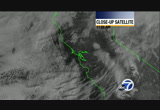
for us in the bay area, the storm is starting to leave the bay area heading towards monterey bay right now. here's a live look from sutro look down toward san francisco and the bay where we are mainly under cloudy conditions. so no rain being reported for bay area cities. but as we go to live doppler 7hd you can see the center of this storm moving toward salinas right now. the areas of green, the rain whipping around in a counter clockwise direction, slight for the most part. salinas reporting slight rain but there have been reports of thunderstorms off the coast over the last few hours. so bay area, just cloudy conditions. a few pockets of showers still expected in the morning hours. temperatures right now in the 40s. that's due to the cloud cover. so definitely not as chilly. and you can expect 46 right now in san francisco, 48 in san jose. so here's the deal for today. morning showers, just some leftover showers. not too heavy. you might not even need an umbrella depending on where you are. then we have afternoon sunshine. it's going to be dry and warmer monday and tuesday. temperat
for us in the bay area, the storm is starting to leave the bay area heading towards monterey bay right now. here's a live look from sutro look down toward san francisco and the bay where we are mainly under cloudy conditions. so no rain being reported for bay area cities. but as we go to live doppler 7hd you can see the center of this storm moving toward salinas right now. the areas of green, the rain whipping around in a counter clockwise direction, slight for the most part. salinas reporting...
305
305
Jan 24, 2013
01/13
by
KGO
tv
eye 305
favorite 0
quote 1
down to the south, that is where we are seeing the best radar returns around the monterey bay and trying to push their way north into the santa clara valley. to the thought we have had clearing leading to the formation of fog so watch out for that with wet streets and reduced visibility, not a great combination. we will find out if it is causing accidents. you can see yellows, and moderate rain around the monterey bay and south and as we head through the day this is going to try to climb to the north is the south bay has the best chance of seeing rain and 2.5 mile visibility in san jose but the fog is three quarter in napa and 1.75 in novato and santa rosa. very mild temperatures, in the upper 40's to mid-50's and this afternoon, temperatures hang out in the upper 50's to mid-60's with the best chance of a shower across the south bay. >> right now it is quiet. we have slick roads can make for dangerous driving conditions so maybe extra time this morning. san jose, 87 northbound direction beyond h.p. pavilion the sharks are in action tonight. it is looking good right now. we have rain at
down to the south, that is where we are seeing the best radar returns around the monterey bay and trying to push their way north into the santa clara valley. to the thought we have had clearing leading to the formation of fog so watch out for that with wet streets and reduced visibility, not a great combination. we will find out if it is causing accidents. you can see yellows, and moderate rain around the monterey bay and south and as we head through the day this is going to try to climb to the...
232
232
tv
eye 232
favorite 0
quote 0
you see how the center of it is right now centered over monterey bay moving toward salinas. but as the rain continues to wrap around counter clockwise around the storm, we will see some light showers in the bay area. we will zoom in a little bit in san francisco so we saw some sprinkles earlier across the golden gate bridge, parts of the bay bridge and along 101 as well heading down toward san bruno. some light rainfall on third street and 280. so look out for that. not a lot of rainfall at this point. the areas of light blue, some of it might not even be making it to the ground all the way but we could see a few sprinkles. hayward reporting light rain as well. you will find it on 880, san mateo bridge, as well as castro valley. then as we check into livermore we also see some light showers being reported, 580, patterson pass road. the showers will continue through the morning hours. just a spotty one here and there. but then it will be all gone for the rest of the day. temperatures right now in the 40s. 46 in san rafael, 48 oakland. so much milder start to the day. not as co
you see how the center of it is right now centered over monterey bay moving toward salinas. but as the rain continues to wrap around counter clockwise around the storm, we will see some light showers in the bay area. we will zoom in a little bit in san francisco so we saw some sprinkles earlier across the golden gate bridge, parts of the bay bridge and along 101 as well heading down toward san bruno. some light rainfall on third street and 280. so look out for that. not a lot of rainfall at...
245
245
tv
eye 245
favorite 0
quote 0
more low 50s around monterey bay with 53 in watsonville, 54 gilroy. here's the accuweather seven-day forecast. just a few spotty showers mainly south of the golden gate later on this morning. so north bay you are pretty much dry. then sunshine and mostly sunny conditions monday. temperatures coming up on tuesday into the low 60s. okay, there's that chance of rain wednesday late into thursday. still looking like a fairly weak system at this point, but then dry again for friday and saturday. >> you said the temperatures are above normal that we are looking at? >> right now we are near normal but they will be above normal on monday, and tuesday definitely. >> thank you, frances. >>> this morning lance armstrong's attorney is denying reports the former cyclist is planning to admit to doping charges. >> in a follow-up story the times says the u.s. anti-doping agency could use armstrong's admission to go over other cyclists suspected of using performance-enhancing drugs. speaking to former teammates the newspaper said armstrong's testimony could provide the
more low 50s around monterey bay with 53 in watsonville, 54 gilroy. here's the accuweather seven-day forecast. just a few spotty showers mainly south of the golden gate later on this morning. so north bay you are pretty much dry. then sunshine and mostly sunny conditions monday. temperatures coming up on tuesday into the low 60s. okay, there's that chance of rain wednesday late into thursday. still looking like a fairly weak system at this point, but then dry again for friday and saturday....
218
218
tv
eye 218
favorite 0
quote 0
monterey bay, upper 50s. mid to upper 50s inland. floss at this inland from 20s and 30s. not as much frost around the bay. palo alto the only spot at about 32 degrees. blocking area of high pressure. jetstream is making a left-hand turn and heading straight up to the arctic circle. that is why there will be high clouds and sunshine but with the locking pattern it will remain dry and warm up to near 60 on friday. next system draws near and puts more cloud cover and drops our temperatures a little bit for the weekend. once it passes we'll get more sunshine and run at 60 degrees for monday and tuesday. >> continuing coverage of this water main break at hayward and jackson street at santa clara. it's still spewing water so you can see they coned it off but another half an hour before they stop the water flow. eastbound ramp from 92 to jackson street is down to one lane. westbound getting by with no problems. this is a sig alert issued by the chp at the intersection of jackson street in hayward. the other problem is san mateo bridge, if you headed in the eastbound direction, no
monterey bay, upper 50s. mid to upper 50s inland. floss at this inland from 20s and 30s. not as much frost around the bay. palo alto the only spot at about 32 degrees. blocking area of high pressure. jetstream is making a left-hand turn and heading straight up to the arctic circle. that is why there will be high clouds and sunshine but with the locking pattern it will remain dry and warm up to near 60 on friday. next system draws near and puts more cloud cover and drops our temperatures a...
151
151
Jan 17, 2013
01/13
by
KGO
tv
eye 151
favorite 0
quote 0
monterey bay, from 64 at monterey to 68 inland to salinas at 67 in watsonville. y air, frost again inland, but not as much around the bay with mid-to-upper 30's and mid-40's around san francisco and half moon bay. the coast, maybe you want to go out this weekend, starting tomorrow night through saturday morning the big issue with the beach hazard is the sneaker waves those that smoke in -- sneak in and grab you. from saturday morning at 10:00 to sunday at 4:00 p.m., the bigger ripping wave that could get up to 20' and strong rip current so, please, be came mavericks is sunday, watch from a distance if you can. our accweather seven seven show low-to-mid 60's throughout the weekend. cooler next week but we are rain free through wednesday. have a great day. >> to the san mateo bridge, it is a good drive from hayward toward foster city with the flat section and a few brake lights, this is the alternate to the bay bridge backup. we had an early stall and i want to show you the traffic app, you can see highway 580 back to 24, very, very heavy, and, also, 880 all jammed
monterey bay, from 64 at monterey to 68 inland to salinas at 67 in watsonville. y air, frost again inland, but not as much around the bay with mid-to-upper 30's and mid-40's around san francisco and half moon bay. the coast, maybe you want to go out this weekend, starting tomorrow night through saturday morning the big issue with the beach hazard is the sneaker waves those that smoke in -- sneak in and grab you. from saturday morning at 10:00 to sunday at 4:00 p.m., the bigger ripping wave that...
195
195
Jan 14, 2013
01/13
by
KGO
tv
eye 195
favorite 0
quote 0
front tray -- minute tray -- monterey bay, 32. frosty inland today, through wednesday morning, and, then, the warmer afternoons will take over and bring us warmer nights and we will be rid of the frost by thursday morning. today, we will have the coolest weather. antioch and livermore 29. 51 in san francisco, a lot of 53 for fremont and san mateo and napa, also. low 50's in the monterey bay and inland. now, what will happen tonight: more 20's and 30's. tonight will be colder than this morning because we have calmer conditions. this afternoon, though, we jump in the mid-50's on tuesday and upper 50's by wednesday and 60's on thursday, friday, saturday, and sunday. looks like a nice stretch of dry weather the. >> and a dry commute and light conditions. so far, so good. look at the golden gate bridge with four lanes for the southbound commute from the waldo tunnel into san francisco with no delays to san jose beyond the soon-to-be shark tank, back in action, and light traffic, and 87 northbound, and the drive from the central valley,
front tray -- minute tray -- monterey bay, 32. frosty inland today, through wednesday morning, and, then, the warmer afternoons will take over and bring us warmer nights and we will be rid of the frost by thursday morning. today, we will have the coolest weather. antioch and livermore 29. 51 in san francisco, a lot of 53 for fremont and san mateo and napa, also. low 50's in the monterey bay and inland. now, what will happen tonight: more 20's and 30's. tonight will be colder than this morning...
278
278
Jan 28, 2013
01/13
by
KGO
tv
eye 278
favorite 0
quote 0
not bad, down around monterey bay and temperatures in the low 50's.zes today from the north and the fastest is over the ocean and we will see just a stray shower. now, tomorrow morning, chilly, but by tomorrow afternoon, we could be near 70 on friday and significant, and, now, all the way through the february forecast, there is no real strong storm in the offing the next two weeks, but deeper in february, possibly, the climate prediction center is say near normal and we are nearly ready to loose our surplus for the rain year. today, a few clouds, with a lot of sunshine and 55 in livermore, and 59 in oakland and monterey bay mid-to-upper 50's and inland mid-to-upper 50's. around the state, it is quiet, a few snow showers in tahoe, yosemite at 39, and low 60's around palm springs. this evening, 30's inland and a few 30's around fremont and palo alto, and low-to-mid 40's for oakland and half moon bay. high pressure to our west, clock rise flow, on the front side of this, we have cold air coming down at us, so today and tomorrow we will be the coolest and
not bad, down around monterey bay and temperatures in the low 50's.zes today from the north and the fastest is over the ocean and we will see just a stray shower. now, tomorrow morning, chilly, but by tomorrow afternoon, we could be near 70 on friday and significant, and, now, all the way through the february forecast, there is no real strong storm in the offing the next two weeks, but deeper in february, possibly, the climate prediction center is say near normal and we are nearly ready to...
172
172
Jan 29, 2013
01/13
by
KGO
tv
eye 172
favorite 0
quote 0
we have temperatures in the low 50s around the monterey bay and inland. thin clouds, a lot of sunshine. breezy at the coast. mostly clear and it will be cooler tonight and looks like we'll have mild temperatures all the way through into the weekend. 56 one of cooler spots, and we'll jump up to 51 for the warm spot. monterey bay, temperatures in the mid to upper 50s there and upper 50s as you head inland. tonight, could be keeper than this morning. scattered frost in inland valleys. 33 at our reporting station in napa but the neighborhoods are cooler than that. 46 in san francisco, one of the warm spots. here is what is happening. players on the map, high pressure to the east. one to the west we're more concerned with that. that is going to shove this cold pocket of air and the high clouds with it off to the east. we'll have high clouds today but more sunshine tomorrow and warmest temperatures around wednesday, thursday and friday and more high clouds and higher than will move off. we'll see a cooling trend for the weekend. here is the seven-day forecast.
we have temperatures in the low 50s around the monterey bay and inland. thin clouds, a lot of sunshine. breezy at the coast. mostly clear and it will be cooler tonight and looks like we'll have mild temperatures all the way through into the weekend. 56 one of cooler spots, and we'll jump up to 51 for the warm spot. monterey bay, temperatures in the mid to upper 50s there and upper 50s as you head inland. tonight, could be keeper than this morning. scattered frost in inland valleys. 33 at our...
172
172
tv
eye 172
favorite 0
quote 0
upper 60's for monterey bay. tonight temperatures not as cool as this morning and we are not flirting with freezing temperatures with most of us in the low-to-mid 40's and a few spots inland in the high 30's. low pressure is moving away and high clouds are dancing across the sky from north to south today as this branch of the jet stream stays to the north another branch to the south, in between two areas of high pressure that will hold for a day and tomorrow and we could see 60's tomorrow before the first system moves in on wednesday and drops the temperatures with a few sprinkles and cold showers on thursday as we barely make it to 50 on thursday and friday but slightly warmer saturday and sunday. >> first report of an accident in hayward area northbound 238 mission, the off-ramp, a vehicle hit a beside. bart and muni and california train running on schedule if the first day back at work if you have had a couple of holiday weeks and westbound, we are seeing slow traffic now, which is typical for morning commute
upper 60's for monterey bay. tonight temperatures not as cool as this morning and we are not flirting with freezing temperatures with most of us in the low-to-mid 40's and a few spots inland in the high 30's. low pressure is moving away and high clouds are dancing across the sky from north to south today as this branch of the jet stream stays to the north another branch to the south, in between two areas of high pressure that will hold for a day and tomorrow and we could see 60's tomorrow...
156
156
Jan 29, 2013
01/13
by
KOFY
tv
eye 156
favorite 0
quote 0
we have temperatures in the low 50s around the monterey bay and inland.hin clouds, a lot of sunshine. breezy at the coast. mostly clear and it will be cooler tonight and looks like we'll have mild temperatures all the way through into the weekend. 56 one of cooler spots, we'll jump up to 51 for the warm spot. monterey bay, temperatures in the mid to upper 50s there and upper 50s as you head inland. tonight, could be keeper than this morning. scattered frost in inland valleys. 33 at our reporting station in napa but the neighborhoods are cooler than that. 46 in san francisco, one of the warm spots. here is what is happening. players on the map, high pressure to the east. one to the west we're more concerned with that. that is going to shove this cold pocket of air and the high clouds with it off to the east. we'll have high clouds today but more sunshine tomorrow and warmest temperatures around wednesday, thursday and friday and more high clouds and higher than will move off. we'll see a cooling trend for the weekend. here is the seven-day forecast. mid 50
we have temperatures in the low 50s around the monterey bay and inland.hin clouds, a lot of sunshine. breezy at the coast. mostly clear and it will be cooler tonight and looks like we'll have mild temperatures all the way through into the weekend. 56 one of cooler spots, we'll jump up to 51 for the warm spot. monterey bay, temperatures in the mid to upper 50s there and upper 50s as you head inland. tonight, could be keeper than this morning. scattered frost in inland valleys. 33 at our...
263
263
Jan 31, 2013
01/13
by
KGO
tv
eye 263
favorite 0
quote 0
heading down to the monterey bay slightly warmer, upper 60s to low 70s. let's take a look at tonight. this morning, a little frost around napa. a little fog up north, but i don't think we'll have fog tonight. mid 40s around the bayshore and out to the coast. san francisco a little warmer, 48 degrees. two areas of high pressure dominateding our weather. i seek a buck until the jetstream. that is going to be flatten this ridge of high pressure, change our wind and bring us cooler conditions but still dry through the weekend. if you are lucky enough to be headed to new orleans, coldest into the 50s. look at the humidity come back as the morning lows closer to where they should be, upper 40s, mid-50s not bad for superbowl sunday. back here at home, let's search out cooler weather, low to mid-60s for saturday, sunday, monday and tuesday. then a cooler air mass comes in and promises at least a chance of rain, something we haven't had in a while on wednesday, highs in the upper 50s to near 60 degrees. pretty nice weather coming up. we need some rain and we need
heading down to the monterey bay slightly warmer, upper 60s to low 70s. let's take a look at tonight. this morning, a little frost around napa. a little fog up north, but i don't think we'll have fog tonight. mid 40s around the bayshore and out to the coast. san francisco a little warmer, 48 degrees. two areas of high pressure dominateding our weather. i seek a buck until the jetstream. that is going to be flatten this ridge of high pressure, change our wind and bring us cooler conditions but...
337
337
tv
eye 337
favorite 0
quote 0
mid-50s on the monterey bay.ide spread 20s are inland and fremont x. 32 in san jose and 35 in oak left-hand. that is where we will have the hard freeze today and tonight. bay shore in santa clara val. temperatures will be in the dangerous category from 11:00 tonight and 9:00 tomorrow morning. pets and plants and possibly pipes. here is an area of disturbed weather kicking up the clouds. once it passes it will usher in the colder air for tonight and today. it will be the slow warming friend and guilty warmer in the weekend with temperatures in the 50s to near 60 degrees. here's kristin. >> some folks are driving home after the parties. giching you a look outside for those of you riding transit. no issues. the extra trains and bus to get folks home and they are now on a holiday schedule for new year's day. you can see traffic is light coming in san francisco. a lot of folks are not working and going to watch the bowl game or rose bowl parade. lights are heading west . you can see folks taking it slow and easing up
mid-50s on the monterey bay.ide spread 20s are inland and fremont x. 32 in san jose and 35 in oak left-hand. that is where we will have the hard freeze today and tonight. bay shore in santa clara val. temperatures will be in the dangerous category from 11:00 tonight and 9:00 tomorrow morning. pets and plants and possibly pipes. here is an area of disturbed weather kicking up the clouds. once it passes it will usher in the colder air for tonight and today. it will be the slow warming friend and...
214
214
tv
eye 214
favorite 0
quote 0
upper 50's around the monterey bay and headed inland. tonight, there will be fog again and i don't think we will be freezing like this morning. frost is going to be minimal, and freezing fog not tonight. 39 is the cool end at santa rosa, the low yesterday was headed toward the baja with the high clouds coming in as the next system is pushed to the northern of us because of this area of high pressure and this area of high pressure. here is what is going to happen going forward. wednesday, at 5:00, remember this is a very large grid on this because the further you go out you cannot crunch so much. this is painting a wide picture of light rain on wednesday evening. the bulk of the storm stays over the mountains and over the beaches and toward the ocean. it looks like wednesday night into thursday morning is our best chance of seeing anything we as far as precipitation that is measurable. we will have scattered showers on thursday. that can bump into the higher elevation. after frost is possible on friday morning, saturday and sunday will be
upper 50's around the monterey bay and headed inland. tonight, there will be fog again and i don't think we will be freezing like this morning. frost is going to be minimal, and freezing fog not tonight. 39 is the cool end at santa rosa, the low yesterday was headed toward the baja with the high clouds coming in as the next system is pushed to the northern of us because of this area of high pressure and this area of high pressure. here is what is going to happen going forward. wednesday, at...
189
189
Jan 31, 2013
01/13
by
KOFY
tv
eye 189
favorite 0
quote 0
heading down to the monterey bay slightly warmer, upper 60s to low 70s.et's take a look at tonight. this morning, a little frost around napa. a little fog up north, but i don't think we'll have fog tonight. mid 40s around the bayshore and out to the coast. san francisco a little warmer, 48 degrees. two areas of high pressure dominateding our weather. i seek a buck until the jetstream. that is going to be flatten this ridge of high pressure, change our wind and bring us cooler conditions but still dry through the weekend. if you are lucky enough to be headed to new orleans, coldest into the 50s. look at the humidity come back as the morning lows closer to where they should be, upper 40s, mid-50s not bad for superbowl sunday. back here at home, let's search out cooler weather, low to mid-60s for saturday, sunday, monday and tuesday. then a cooler air mass comes in and promises at least a chance of rain, something we haven't had in a while on wednesday, highs in the upper 50s to near 60 degrees. pretty nice weather coming up. we need some rain and we need so
heading down to the monterey bay slightly warmer, upper 60s to low 70s.et's take a look at tonight. this morning, a little frost around napa. a little fog up north, but i don't think we'll have fog tonight. mid 40s around the bayshore and out to the coast. san francisco a little warmer, 48 degrees. two areas of high pressure dominateding our weather. i seek a buck until the jetstream. that is going to be flatten this ridge of high pressure, change our wind and bring us cooler conditions but...
184
184
Jan 22, 2013
01/13
by
KGO
tv
eye 184
favorite 0
quote 0
monterey bay is upper 60's to low 70's around the bay and headed inland.w-to-upper 40's but fairfield is at 39 degrees. we have a front that will come in tomorrow. you can see the wall of water to the west. so we will have high clouds today starting at noon we will have scattered light showers that will spread dug the afternoon and early evening and .1" is possible and up to .5" on the coast and temperature in the 50's for the weekend with scattered chance of a shower then. >> the rest spot this morning is semi-i-- is san mateo with two separate incidents 100 in the right lane and one in the left lane. and over 30 minutes ago the major accident was reported and you can see the backup beyond 92, now, as you move from northbound on the pens there so 280 is the great alternate. you can download this agree app from apple app and google play and c.h.p. is saying the stalled bus is still blocking the ramp northbound 680 great north 101 with very slow traffic from south san jose coming up on 101. kristen and eric? >> thank you, sue. ahead, five things to know bef
monterey bay is upper 60's to low 70's around the bay and headed inland.w-to-upper 40's but fairfield is at 39 degrees. we have a front that will come in tomorrow. you can see the wall of water to the west. so we will have high clouds today starting at noon we will have scattered light showers that will spread dug the afternoon and early evening and .1" is possible and up to .5" on the coast and temperature in the 50's for the weekend with scattered chance of a shower then. >>...
273
273
tv
eye 273
favorite 0
quote 0
monterey bay, temperatures mid to upper 50s.hecking out the accu-weather forecast, colder air coming in. that is not going to be the case. look at thursday, only into low 50s. cold morning friday. dry, saturday, sunday, now looking dry as you can see there. we'll see sunshine as highway ae head into next week. temperatures moderating. by the way, 49ers game this saturday night is going to be cold. i'm abc 7 news meteorologist sandhya patel. bundle up incoming day autos we'll be cold at the game, but victorious. thank you very much. tonight jimmy kimmel makes a big move to an earlier time airing after abc 7 news at 11:00. abc 7 news morning anchor interviewed jimmy by satellite he says he's excited to go up against his long time idols but just going to be him sex he's kicking things off with a new set and a who's who list of stars beginning with jennifer aniston, tonight she's never been on the show before. so it will be fun to have her, then first couple weeks we have a great line up of ryan gosling, dr. oz, ellen degenerous. ro
monterey bay, temperatures mid to upper 50s.hecking out the accu-weather forecast, colder air coming in. that is not going to be the case. look at thursday, only into low 50s. cold morning friday. dry, saturday, sunday, now looking dry as you can see there. we'll see sunshine as highway ae head into next week. temperatures moderating. by the way, 49ers game this saturday night is going to be cold. i'm abc 7 news meteorologist sandhya patel. bundle up incoming day autos we'll be cold at the...
104
104
tv
eye 104
favorite 0
quote 0
same thing around monterey bay. 59 headed inland to morgan hill and everyone else is in the low 60's of the tonight, mostly mid-to-upper 30's inland and mid-30's to mid-40's around the bay sure with clouds tonight no threat of frost. it is over. high pressure right now, most of the system is to the north but this is a very big system that will shove the high pressure out of the way. here is how: tomorrow morning the clouds roll in and this is one of the faster of the models of the three i look at and it has the rain coming in, moderate rain by 3:00, it will be around during later in the day and early evening. the other models bring it toward the evening. it means on saturday morning, for sure, it will be dry if you need to do stuff outside. overnight it will be dry. we wake up to more cloud cover on sunday and the next system rolling down with moderate rain in the north bay. and light-to-moderate rain later in the afternoon. we get up to three quarters of an inch of rain around the bear and up to 1" in the north bay. the accweather forecast shows with the rain it will be cooler and l
same thing around monterey bay. 59 headed inland to morgan hill and everyone else is in the low 60's of the tonight, mostly mid-to-upper 30's inland and mid-30's to mid-40's around the bay sure with clouds tonight no threat of frost. it is over. high pressure right now, most of the system is to the north but this is a very big system that will shove the high pressure out of the way. here is how: tomorrow morning the clouds roll in and this is one of the faster of the models of the three i look...
272
272
Jan 14, 2013
01/13
by
KGO
tv
eye 272
favorite 0
quote 0
we will be in the low 50's around monterey bay and headed inland, low-to-mid 50's and total sunshine everywhere today. tonight, we do not have the wind so we will have more wide-spread frost than this morning. it will be one of the last nights, with the frost. mid-50's tomorrow and mid-to-upper 50's on wednesday and low 60's on thursday and mid-60's throughout the week end. it will be warmer eventually. >> good morning, mike, getting busy on the san mateo bridge headed to the foster city area, the tail lights are bunching up to the high-rise, eastbound to hayward, we have reports of a stalled right lane eastbound reverse commute. here is back to the abc traffic app, the waves app, heavy traffic southbound 680 through fremont, we had early three car accident to mission boulevard and heavy traffic is now stacking up, and free app at apple app and google play. what could be a serious accident, now, forming here, southbound 101 at broadway. we will follow this for you, as well. >> thank you. >> ahead, five things to know before you go. the >> as we get ready to hand things off to "good m
we will be in the low 50's around monterey bay and headed inland, low-to-mid 50's and total sunshine everywhere today. tonight, we do not have the wind so we will have more wide-spread frost than this morning. it will be one of the last nights, with the frost. mid-50's tomorrow and mid-to-upper 50's on wednesday and low 60's on thursday and mid-60's throughout the week end. it will be warmer eventually. >> good morning, mike, getting busy on the san mateo bridge headed to the foster city...
220
220
Jan 18, 2013
01/13
by
KGO
tv
eye 220
favorite 0
quote 0
nice around monterey bay in the upper 60's and tonight we will still have frost inland. but not around the bay and to the coast. we will be in the mid-30's to low 40's. the beach hazard this afternoon, through tomorrow morning, this is for the sneaker waves up and down the coast and occasionally we could get 20' wave but the bigger waves are more steady from saturday morning at 10:00, tomorrow morning, until sunday, at 4:00. that is when the dangerous rip current develop. here is the appropriations accw, low-to-mid 60's for monday and tuesday and the system passes us to the north and missions us with rain but drops the temperatures back in the 60's to near 60-degree range wednesday and thursday. have a good day. sue? >> san jose, 87 northbound, beyond the h.p. pavilion, very light. lady gaga finished up her show but now everything is cleared and it looks good northbound. this is the off-ramp h.p. pavilion on the left hand side. northbound to san rafael we have light conditions if your drive takes you to novato and southern marin it is looking good. to the waled -- waldo g
nice around monterey bay in the upper 60's and tonight we will still have frost inland. but not around the bay and to the coast. we will be in the mid-30's to low 40's. the beach hazard this afternoon, through tomorrow morning, this is for the sneaker waves up and down the coast and occasionally we could get 20' wave but the bigger waves are more steady from saturday morning at 10:00, tomorrow morning, until sunday, at 4:00. that is when the dangerous rip current develop. here is the...
244
244
Jan 18, 2013
01/13
by
KGO
tv
eye 244
favorite 0
quote 0
monterey bay, too. and a few 70's around salinas. tonight, we will have frost inland. but not around the bay and to the coast with mid-30's to low 40s. sneaker waves possibility tonight through tomorrow morning. and steady big waves saturday at 10:00 through sunday at 4:00 p.m. so saturday 10:00 a.m. until sunday 4:00 p.m. and in the middle of that is maverick at half moon bay. you are in the 60's by 11:00 and mid-60 in the afternoon. gorgeous at the coast but for the dangerous coast. mid-to-upper 60's for highs this weekend and back to the 50's wednesday and thursday. it will still be dries though. >> headed to the coast especially half moon bay expect major delays on highway 92. san mateo area southbound 280 beyond 92 that accident has been clear where two cars and several deer and chp had to shut down the southbound 280 to clear that up. it is now re-opened. traffic is getting by without delay. elsewhere, we have good looking dry on 80 westbound into macarthur maze. it is crowded but no major stalls or accidents. funneling to the bay bridge toll plaza the metering l
monterey bay, too. and a few 70's around salinas. tonight, we will have frost inland. but not around the bay and to the coast with mid-30's to low 40s. sneaker waves possibility tonight through tomorrow morning. and steady big waves saturday at 10:00 through sunday at 4:00 p.m. so saturday 10:00 a.m. until sunday 4:00 p.m. and in the middle of that is maverick at half moon bay. you are in the 60's by 11:00 and mid-60 in the afternoon. gorgeous at the coast but for the dangerous coast....
252
252
Jan 12, 2013
01/13
by
KGO
tv
eye 252
favorite 0
quote 0
a nice cool day in monterey bay. it is 49ers playoff against the green bay packers. if you are heading to the game make sure you have a jacket or sweater. it will be cold, but dry. by 8:00 p.m. mid40s at the stick. it will be a little breezy so you know how it goes there. accu-weather seven-day forecast. freeze warning tomorrow morning for the valleys. frost advisories for the bay shoreline. keeping it bone chilling cold on sunday and monday mornings and then we will warm it up for you. warmer daytime highs. low 60s showing up thursday and friday. and now carolyn and dan, you both know that winter is here in the bay area. not the same as they were about 10 years ago or even 20 years ago. the abc7 news weather team and i are exploring decades of data to document how climate change is affecting weather here. climate changing is one of the pop particulars we are looking into for -- topics we are looking into. it is the special "inside bay area weather." it airs on sunday evening, this sunday evening at 6:30 right here on abc7 news. picks, climate change. s . >>> we have
a nice cool day in monterey bay. it is 49ers playoff against the green bay packers. if you are heading to the game make sure you have a jacket or sweater. it will be cold, but dry. by 8:00 p.m. mid40s at the stick. it will be a little breezy so you know how it goes there. accu-weather seven-day forecast. freeze warning tomorrow morning for the valleys. frost advisories for the bay shoreline. keeping it bone chilling cold on sunday and monday mornings and then we will warm it up for you. warmer...
122
122
Jan 14, 2013
01/13
by
KGO
tv
eye 122
favorite 0
quote 0
low-to-mid 50's throughout the area, and monterey bay low-to-mid 50's. tonight, we still have frost inland and scattered frost around the bay including oakland and san mateo and half moon bay probably no frost. a couple of areas dropping the temperatures. check out these temperatures on the seven-day outlook, by wednesday, mid-to-upper 50's where we should be. look at the string of 60's for friday, saturday, and sunday. dry all seven days in the forecast. >> owe first look at the san mateo bridge this morning, light traffic condition, a few brake lights moving toward the high-rise from the flat section but looking at 14 minutes between hayward and fogs -- foster city. string of headlights at marin ymca to central san rafael, smooth sailing to golden gate bridge and from hillcrest to highway 242, it is smooth sailing. from the central valley, nice and at the limit up and over the altamont pass to dublin/pleasanton area. kristen and eric? >> 4:50. >> an outage at the worst time the bay area senior center without hot water for days. >> and keeping watching
low-to-mid 50's throughout the area, and monterey bay low-to-mid 50's. tonight, we still have frost inland and scattered frost around the bay including oakland and san mateo and half moon bay probably no frost. a couple of areas dropping the temperatures. check out these temperatures on the seven-day outlook, by wednesday, mid-to-upper 50's where we should be. look at the string of 60's for friday, saturday, and sunday. dry all seven days in the forecast. >> owe first look at the san...
119
119
Jan 31, 2013
01/13
by
KGO
tv
eye 119
favorite 0
quote 0
around monterey bay, 70.night are still a few 30's inland, mid-30's there to 42 in antioch and upper 30's to mid-40's around the bay and san francisco is the warm spot at 48. high pressure here, dominating our weather, and feeling a little pinched by the trough up to our north but we are going to remain high and dry all the way through the weekend. check it out, not something you want to see, the third driest january in san francisco. checking the other areas, we have had more rain down in san jose than we have had in san francisco. that is pretty unusual. the seven-day outlook shows the warmest weather today and tomorrow above average saturday, sunday, monday, and tuesday. finally, a couple of chances of rain for wednesday, thursday, and saturday of next week. have a great day. eric and kristen? >> thank you, our time is 4:49. one of the largest public colleges is on the brink of closing and the action today is expected to keep the doors open for tens of thousands. >> you may want to arrange your change door
around monterey bay, 70.night are still a few 30's inland, mid-30's there to 42 in antioch and upper 30's to mid-40's around the bay and san francisco is the warm spot at 48. high pressure here, dominating our weather, and feeling a little pinched by the trough up to our north but we are going to remain high and dry all the way through the weekend. check it out, not something you want to see, the third driest january in san francisco. checking the other areas, we have had more rain down in san...
180
180
Jan 12, 2013
01/13
by
KOFY
tv
eye 180
favorite 0
quote 0
a nice cool day in monterey bay. it is 49ers playoff against the green bay packers. if you are heading to the game make sure you have a jacket or sweater. it will be cold, but dry. by 8:00 p.m. mid40s at the stick. it will be a little breezy so you know how it goes there. accu-weather seven-day forecast. freeze warning tomorrow morning for the valleys. frost advisories for the bay shoreline. keeping it bone chilling cold on sunday and monday mornings and then we will warm it up for you. warmer daytime highs. low 60s showing up thursday and friday. and now carolyn and dan, you both know that winter is here in the bay area. not the same as they were about 10 years ago or even 20 years ago. the abc7 news weather team and i are exploring decades of data to document how climate change is affecting weather here. climate changing is one of the pop particulars we are looking into for -- topics we are looking into. it is the special "inside bay area weather." it airs on sunday evening, this sunday evening at 6:30 right here on abc7 news. picks, climate change. s . >>> we have
a nice cool day in monterey bay. it is 49ers playoff against the green bay packers. if you are heading to the game make sure you have a jacket or sweater. it will be cold, but dry. by 8:00 p.m. mid40s at the stick. it will be a little breezy so you know how it goes there. accu-weather seven-day forecast. freeze warning tomorrow morning for the valleys. frost advisories for the bay shoreline. keeping it bone chilling cold on sunday and monday mornings and then we will warm it up for you. warmer...
151
151
Jan 12, 2013
01/13
by
KGO
tv
eye 151
favorite 0
quote 0
a nice cool day in monterey bay. it is 49ers playoff against the green bay packers.are heading to the game make sure you have a jacket or sweater. it will be cold, but dry. by 8:00 p.m. mid40s at the stick. it will be a little breezy so you know how it goes there. accu-weather seven-day forecast. freeze warning tomorrow morning for the valleys.t advisi frost advisories for the bay shoreline. keeping it bone chilling cold on sunday and monday mornings and then we will warm it up for you. warmer daytime highs. low 60s showing up thursday and friday. and now carolyn and dan, you both know that winter is here in the bay area. not the same as they were about 10 years ago or even 20 years ago. the abc7 news weather team and i are exploring decades of data to document how climate change ier here affecting weather here. climate changing is one of the pop particulars we are looking into for -- topics we are looking into. it is the special "inside bay area weather." it airs on sunday evening, this sunday evening at 6:30 right here on abc7 news. picks, climate change. s . >>> w
a nice cool day in monterey bay. it is 49ers playoff against the green bay packers.are heading to the game make sure you have a jacket or sweater. it will be cold, but dry. by 8:00 p.m. mid40s at the stick. it will be a little breezy so you know how it goes there. accu-weather seven-day forecast. freeze warning tomorrow morning for the valleys.t advisi frost advisories for the bay shoreline. keeping it bone chilling cold on sunday and monday mornings and then we will warm it up for you. warmer...
244
244
Jan 24, 2013
01/13
by
KGO
tv
eye 244
favorite 0
quote 0
some lingering showers in the money you tay -- monterey bay. dry for friday. chance of showers on saturday and mainly in the morning midday hours. and then there is a slight possibility of showers on monday. computers in disagreement. and then we will go with a dry and milder forecast. we have our own radar along with the national weather service. we will be tracking this rain for you and keeping you posted for the upcoming weekend. >> thank you, sandhya. >>> let's check in on sports right now. >> about a week to go and then we have this big game. you are getting ready to go to new orleans. >> yes, it will be fun. we will check in with vernon davis and another statement win for the warriors as curry is stuffing the ballot box for allstar votes. so, we all set? i've got two tickets to paradise! pack your bags, we'll leave tonight. uhh, it's next month, actually... eddie continues singing: to tickets to... paradiiiiiise! no four. remember? whoooa whooaa whooo! you know ronny, folks who save hundreds of dollars by switching to geico sure are happy. and how happy
some lingering showers in the money you tay -- monterey bay. dry for friday. chance of showers on saturday and mainly in the morning midday hours. and then there is a slight possibility of showers on monday. computers in disagreement. and then we will go with a dry and milder forecast. we have our own radar along with the national weather service. we will be tracking this rain for you and keeping you posted for the upcoming weekend. >> thank you, sandhya. >>> let's check in on...
180
180
Jan 18, 2013
01/13
by
KGO
tv
eye 180
favorite 0
quote 0
warmer weather around monterey bay and inland upper 60's to low 70's. ll have 20's and 30's inland and scattered forecast there and no frost around the bay shore and to the coast mid-30's to mid-40's and possibility of sneaker waves through saturday morning and the surf is rougher on saturday at 10:00 until sunday at 4:00, and 20' swells and rip currents. in the 60's in the afternoon when the surfing competition begins. next week we will be back in the 50's to near 60 wednesday and thursday. >> problem westbound 580 a hit-and-run accident with rubberneckers slowing things out of the central valley toward the altamont pass. it picks up and you are looking under 25 minutes to 580 and 680. a serious accident eastbound river road all lanes are blocked with fire crews and emergency crews with four cars involved west of highway 101 in the sap that rose area. 280 southbound beyond 92 a problem with two cars that hit a deer blocking a left lane. it was originally in two lanes but now just one lane affected. always a problem spot in that area so take extra cautio
warmer weather around monterey bay and inland upper 60's to low 70's. ll have 20's and 30's inland and scattered forecast there and no frost around the bay shore and to the coast mid-30's to mid-40's and possibility of sneaker waves through saturday morning and the surf is rougher on saturday at 10:00 until sunday at 4:00, and 20' swells and rip currents. in the 60's in the afternoon when the surfing competition begins. next week we will be back in the 50's to near 60 wednesday and thursday....
183
183
Jan 17, 2013
01/13
by
KGO
tv
eye 183
favorite 0
quote 0
mid-to-upper 60's around monterey bay and 61 at morgan hill. tonight, the temperatures show 20's and 30's inland again, frost there, mid-to-upper 30's around the bay shore, and mid-40's around san francisco and half moon bay. we have a beach hazard report if tomorrow night through saturday because of the sneaker waves, the bigger waves will be starting saturday night through sunday at 4:00 with the swells possibly up to 20' so we want you to stay out of the water. the accweather seven-day outlook show low-to-mid 60's through sunday and cooler next week and it is still dry with the 50's on wednesday. have a great day. sioux? >> back to the bay bridge? >> before treasure island, right here, you can see the emergency lights blinking waiting for a tow truck. it is a pickup truck. brake lights all the way back on the incline section and traffic is slowing when you get beyond the toll plaza. so far, no delays at the toll plaza as they wait for the stall to be removed from the upper deck. and lucas valley road we have reports of a stall partly blocking
mid-to-upper 60's around monterey bay and 61 at morgan hill. tonight, the temperatures show 20's and 30's inland again, frost there, mid-to-upper 30's around the bay shore, and mid-40's around san francisco and half moon bay. we have a beach hazard report if tomorrow night through saturday because of the sneaker waves, the bigger waves will be starting saturday night through sunday at 4:00 with the swells possibly up to 20' so we want you to stay out of the water. the accweather seven-day...
178
178
Jan 22, 2013
01/13
by
KGO
tv
eye 178
favorite 0
quote 0
to monterey bay we will have high clouds and sunshine and slightly warmer temperatures, upper 60's to and 72 in salinas for the warm spot inland. tonight, hartley a temperature in the 30's, with fairfield at 39 and everyone else in the low-to-upper 40's. that is what the increasing clouds and increase moisture they bring will do to our temperatures. it is frost-free forecast finally. the clouds from the arctic circling to the tropics with the high pressure holding it at bay right now. it will breakdown today and that is why we have an increase in the higher clouds and the humidity and a chance of light showers especially in the north bay tomorrow. here we are, looking at temperatures and rainfall that is going to cool us by tomorrow and we could get .1" in the south bay and east bay. for the coast, the bay, and the north bay, a quarter to half an itch so a nice rain the we have not had one in 10 or 11 days and the temperatures over the weekend mid-to-upper 50's with a possibility of more wet weather. have a great day. sue? >> back to san leandro with an accident at 238 which is new cl
to monterey bay we will have high clouds and sunshine and slightly warmer temperatures, upper 60's to and 72 in salinas for the warm spot inland. tonight, hartley a temperature in the 30's, with fairfield at 39 and everyone else in the low-to-upper 40's. that is what the increasing clouds and increase moisture they bring will do to our temperatures. it is frost-free forecast finally. the clouds from the arctic circling to the tropics with the high pressure holding it at bay right now. it will...
212
212
Jan 15, 2013
01/13
by
KGO
tv
eye 212
favorite 0
quote 0
around monterey bay and inland mid-to-upper 50's. no freezing temperatures around the bay. 41 in san francisco. headed inland, we are close with 30's and 31 and 32 so there will be scattered frost. a couple areas of high pressure and it is not moving and over the next couple of days here is our cold air mass, wednesday, thursday, it is getting chipped away as mild weather comes in, for the weekend and the cold air mass retreats. there is rain to the west but the seven-day outlook is dry all seven days with temperatures in the low-to-mid 60's friday through monday. have a great day. >> the early accident on the bay bridge cleared a couple of minutes ago and upper deck is looking good with no problems behind the toll plaza and san mateo bridge a few brake lights from the flat section to the high-rise and to foster city but you still have less than 15 minutes between hayward and foster city. south golden gate bridge is light conditions into san francisco. we have slow traffic from antioch. we are getting reports of capital corridor dela
around monterey bay and inland mid-to-upper 50's. no freezing temperatures around the bay. 41 in san francisco. headed inland, we are close with 30's and 31 and 32 so there will be scattered frost. a couple areas of high pressure and it is not moving and over the next couple of days here is our cold air mass, wednesday, thursday, it is getting chipped away as mild weather comes in, for the weekend and the cold air mass retreats. there is rain to the west but the seven-day outlook is dry all...
221
221
Jan 31, 2013
01/13
by
KGO
tv
eye 221
favorite 0
quote 0
headed to monterey bay and underland, everyone in the upper 60's to low 70's with total sunshine. tonight, the temperatures are mid-30's to low 40's inland and not as frosty as this o around napa or as foggy and san francisco is warmer at 49 degrees. high pressure is dominating our weather and kink up to the north which is the energy moving over the top of the high and moving away from us and i think we will be high and dry through the weekend which is unfortunate because we are living in our third driest january here in san francisco with half an inch and we have only had a third in oakland and two-thirds of an inch in san jose. we need more rain and mountain snow. it is just not out there with temperatures near 70 today and tomorrow and our warmest spot and low-to-mid 60's saturday, sunday, monday and tuesday and cooler weather with our first chance of showers on wednesday. have a great day. kristen and eric? >> super bowl coverage continues live from new orleans with the event putting fans right in the middle of the big game. >> but, first, a law school is in trouble with new n
headed to monterey bay and underland, everyone in the upper 60's to low 70's with total sunshine. tonight, the temperatures are mid-30's to low 40's inland and not as frosty as this o around napa or as foggy and san francisco is warmer at 49 degrees. high pressure is dominating our weather and kink up to the north which is the energy moving over the top of the high and moving away from us and i think we will be high and dry through the weekend which is unfortunate because we are living in our...
158
158
Jan 24, 2013
01/13
by
KOFY
tv
eye 158
favorite 0
quote 0
some lingering showers in the money you tay -- monterey bay. dry for friday.e of showers on saturday and mainly in the morning midday hours. and then there is a slight possibility of showers on monday. computers in disagreement. and then we will go with a dry and milder forecast. we have our own radar along with the national weather service. we will be tracking this rain for you and keeping you posted for the upcoming weekend. >> thank you, sandhya. >>> let's check in on sports right now. >> about a week to go and then we have this big game. you are getting ready to go to new orleans. >> yes, it will be fun. we will check in with vernon davis and another statement win for the warriors as curry is stuffing the ballot box for [ woman ] ring. ring. progresso. i just served my mother-in-law your chicken noodle soup but she loved it so much... i told her it was homemade. everyone tells a little white lie now and then. but now she wants my recipe [ clears his throat ] [ softly ] she's right behind me isn't she? [ male announcer ] progresso. you gotta taste this soup
some lingering showers in the money you tay -- monterey bay. dry for friday.e of showers on saturday and mainly in the morning midday hours. and then there is a slight possibility of showers on monday. computers in disagreement. and then we will go with a dry and milder forecast. we have our own radar along with the national weather service. we will be tracking this rain for you and keeping you posted for the upcoming weekend. >> thank you, sandhya. >>> let's check in on sports...
187
187
tv
eye 187
favorite 0
quote 0
half moon bay, warm spot at 55. 58 around the monterey bay. 59 in salinas. have frost in the inland valleys but less likely around the bayshore. palo alto around 32 degrees. 43 tomorrow in san francisco. as we look what is going on here same players on the map that were here yesterday. high pressure is dominating the western half of the united states. notice the clouds streaming well up to the north and as these lows get close to the highs, they fall apart or follow the jetstream up to the north. that is why we'll have a dry pattern. you can get close enough, showers will be offshore and that is where they will stay. 60 on friday and slightly cooler on saturday and sunday. once that storm system passes. 60 for the highs. >>> we're looking at live shot behind me hayward. breaking news with the water main break. you can see it bubbling upright mere. this is intersection of jackson and santa clara. that intersection has been cordoned off. here is the freeway exit from eastbound 92. one lane is getting by the right lane is blocked off. chp is there. you can see
half moon bay, warm spot at 55. 58 around the monterey bay. 59 in salinas. have frost in the inland valleys but less likely around the bayshore. palo alto around 32 degrees. 43 tomorrow in san francisco. as we look what is going on here same players on the map that were here yesterday. high pressure is dominating the western half of the united states. notice the clouds streaming well up to the north and as these lows get close to the highs, they fall apart or follow the jetstream up to the...
282
282
Jan 13, 2013
01/13
by
KGO
tv
eye 282
favorite 0
quote 0
down by the monterey bay we will see about 52 in watsonville and salinas. overnight tonight, once again it's likely the national weather service will have a frost advisory and a freeze warning for valleys and the bay shores with 20s and 30s. then you will notice mid-50s by tuesday and wednesday. still lots of sunshine, upper 50s to the lower 60s by the end of the work week. so we will that you out eventually, but certainly cold out there. >> so will that be this the normal range when we start that that you? >> absolutely. >> thank you, lisa. coming up at 7:00, good morning america. we are joined live this morning from new york to tell us what you guys are working on. hello. good morning. >> the seven-year-old is adorable, the brother and sister is adorable, you will need a box of tissue. >> so a seven-year-old got them together? >> he did with the help of some technology. a little facebook. >> oh, these kids, they are so tech logically savvy these days. >> they are. >> we will watch for that. did you tell us congratulations for our 49ers? >> congratulations!
down by the monterey bay we will see about 52 in watsonville and salinas. overnight tonight, once again it's likely the national weather service will have a frost advisory and a freeze warning for valleys and the bay shores with 20s and 30s. then you will notice mid-50s by tuesday and wednesday. still lots of sunshine, upper 50s to the lower 60s by the end of the work week. so we will that you out eventually, but certainly cold out there. >> so will that be this the normal range when we...
145
145
tv
eye 145
favorite 0
quote 0
in the monterey bay, everyone reaches 60 but morgan hill is close at 59 degrees. tonight with the extra clouds and no frost developing. mid-30's to mid-40's around the bay and to the coast. high pressure is holding on but it is overrun by the high clouds and the next system is strong enough to shove the high out of the way so it will be wet this weekend. there are two systems. the first comes from the west. you can see the rain moving in, in the afternoon and evening with yellow and it will be light-to-moderate rain. as we head overnight we get define the systems and wake up sunday morning and it will be quiet, and by sunday afternoon the rain moving northbound to southbound across the bay and you saw yellows in this and light-to-moderate rain and this hangs around a little bit longer into the evening hours and we will get heavier rain. most of our neighborhoods will get three quarters and the higher elevations of green and up to an inch or 1.5" of rain, and when this passes we will be dry on monday and tuesday and another chance on wednesday and dry again on thur
in the monterey bay, everyone reaches 60 but morgan hill is close at 59 degrees. tonight with the extra clouds and no frost developing. mid-30's to mid-40's around the bay and to the coast. high pressure is holding on but it is overrun by the high clouds and the next system is strong enough to shove the high out of the way so it will be wet this weekend. there are two systems. the first comes from the west. you can see the rain moving in, in the afternoon and evening with yellow and it will be...
219
219
Jan 24, 2013
01/13
by
KPIX
tv
eye 219
favorite 0
quote 0
a closer look, you can see down into the monterey bay you see a lot of that moisture in that direction. some of this will sweep up toward the bay area throughout the day today so we are going to leave a chance of showers in the forecast. you get the idea. core of the low down here and some of this moisture going to sweep up in our direction. so keep that umbrella handy. a chance of showers for today. and a lot of clouds out there, very moist atmosphere and mild temperatures this morning. numbers now in the 40s and 50s. this afternoon, we are going to see clouds and still a chance of a few more scattered showers with an unsettled weather pattern and for the first time we have seen showers move back here in quite some time. the temperatures in the 50s, maybe some low 60s by the afternoon. a chance of more rain is on the way. we will talk about that coming up. right now let's check the roads with elizabeth. >> thank you, lawrence. we'll get a check of the bay bridge first, where there is some roadwork on the incline section of the bridge this morning. two right lanes are blocked until 5 a
a closer look, you can see down into the monterey bay you see a lot of that moisture in that direction. some of this will sweep up toward the bay area throughout the day today so we are going to leave a chance of showers in the forecast. you get the idea. core of the low down here and some of this moisture going to sweep up in our direction. so keep that umbrella handy. a chance of showers for today. and a lot of clouds out there, very moist atmosphere and mild temperatures this morning....
233
233
Jan 13, 2013
01/13
by
KGO
tv
eye 233
favorite 0
quote 0
and down by the monterey bay, yeah, beginning to that you out there.w, i guess it's fine for the east coast to warm up a little bit because their time is coming as soon as tomorrow. they will cool off upper 20s and 30s. back home here, that will be our coldest morning for the next several days. we will warm up and have the overnight lows still chilly, but not as cold as they were this morning and tomorrow morning. >> i don't wish bad weather on the folks back east but i'm glad it's going to warm up here. >> 20 to 30 degrees above normal, that's just not right there. >> thanks, lisa. well, we know that wintry mixner the bay area is much different now than it was ten years ago. the abc7 news weather team is exploring decades of data documenting out climate change is affecting weather here. it's for a special airing this evening. you will also hear how the bay area microclimates make the weather here different than just about anywhere else on earth. >> topography is one of the main reasons that we have such diverse weather conditions from location to loca
and down by the monterey bay, yeah, beginning to that you out there.w, i guess it's fine for the east coast to warm up a little bit because their time is coming as soon as tomorrow. they will cool off upper 20s and 30s. back home here, that will be our coldest morning for the next several days. we will warm up and have the overnight lows still chilly, but not as cold as they were this morning and tomorrow morning. >> i don't wish bad weather on the folks back east but i'm glad it's going...
327
327
Jan 24, 2013
01/13
by
KGO
tv
eye 327
favorite 0
quote 0
before the monterey bay, temperatures into low to mid-60s.accu-weather forecast morning showers, then drying out friday looking fine. cooler upper 50s to low 60s and a chance of showers saturday afternoon with clearing expected sunday. one model wants to hold on to possibility of rain. temperatures are cooler. i won't answerel weekend plans. doesn't look like a wash out with this system. >> thank you. >> coming up next, the strange story keeps getting stranger. >> in los angeles an elementary schoolteacher is accused of committing lewd acts on students and is being held on $12 million bail, prosecutors filed sex charges on him but they believe' bused seven more. >> police say the sexual assault case against michael crabtree appears to be falling apart. abc 7 news learned it allegedly took place in a room at the w hotel in san francisco january 12th. a woman reported the incident to police four days later, sources have told vic lee a second witness now has come forward to say the sex between crabtree and the woman was consensual. both witnesse
before the monterey bay, temperatures into low to mid-60s.accu-weather forecast morning showers, then drying out friday looking fine. cooler upper 50s to low 60s and a chance of showers saturday afternoon with clearing expected sunday. one model wants to hold on to possibility of rain. temperatures are cooler. i won't answerel weekend plans. doesn't look like a wash out with this system. >> thank you. >> coming up next, the strange story keeps getting stranger. >> in los...
178
178
Jan 15, 2013
01/13
by
KGO
tv
eye 178
favorite 0
quote 0
three degrees cooler and antioch is the cool spot and 58 is the warm spot in santa rosa, and the monterey bayemperatures in the mid-to-upper 50's. the temperatures tonight show frosty 30's inland and mainly mid-30's to low 40's around the bay explore and to the coast. the inland valley that would have the frost. stubborn area of high pressure, boom, they have dropped anchor and they will stay that way but look at the cold air mass as we head deeper, on thursday, friday, saturday, and it is retreating to the east and mild temperatures coming our way. no rain, though, not a drop ahead in the seven-day outlook but check out when the warmest temperatures are, low-to-mid 50's for saturday and sunday. have a great day. >> if your travels take you to los angeles, this is a like picture from southern california right near dodger stadium a big rig hit the center divide, it was a fuel tanker. it cause on fire. both directions of i-5 are shut down in los angeles at the dodger stadium area so avoid that area. the traffic, there, is stopped. some is getting by on the side street but his 5 is shut down in
three degrees cooler and antioch is the cool spot and 58 is the warm spot in santa rosa, and the monterey bayemperatures in the mid-to-upper 50's. the temperatures tonight show frosty 30's inland and mainly mid-30's to low 40's around the bay explore and to the coast. the inland valley that would have the frost. stubborn area of high pressure, boom, they have dropped anchor and they will stay that way but look at the cold air mass as we head deeper, on thursday, friday, saturday, and it is...
198
198
Jan 20, 2013
01/13
by
KGO
tv
eye 198
favorite 0
quote 0
down by the monterey bay. and 31 gilroy with 54 in monterey. e stronger offshore winds allowing for the temperatures to stay up. we are a little warmer this morning in san francisco pushes cooler by 4 degrees in novato and two degrees cooler toward the east bay. we will begin to see subtle changes in the days ahead. no spare the air. looking at a little bit of patchy valley fog. the high surf advisory again today and then things are shifting in the atmosphere, allowing for although the mild days, a few more high clouds as we head toward tuesday. so with that high surf advisory right through the afternoon, we are washing watching the northwesterly swell up to 20 feet potentially. up to 7 feet monterey bay and 8 feet san francisco and half moon bay. double barrel high pressure allowing for the offshore flow and the strong ridge in the upper levels of the atmosphere pumping the storm track well to the north. this system will break down and as it does it will allow for the increasing clouds and a weak weather system by tuesday and into wednesday. be
down by the monterey bay. and 31 gilroy with 54 in monterey. e stronger offshore winds allowing for the temperatures to stay up. we are a little warmer this morning in san francisco pushes cooler by 4 degrees in novato and two degrees cooler toward the east bay. we will begin to see subtle changes in the days ahead. no spare the air. looking at a little bit of patchy valley fog. the high surf advisory again today and then things are shifting in the atmosphere, allowing for although the mild...
177
177
Jan 29, 2013
01/13
by
KGO
tv
eye 177
favorite 0
quote 0
we have upper 30s to mid-40s in the monterey bay and inland.e free details about the forecast and fill in the blanks. breezy at the coast. and sunny day . clear and calm and coldest night tonight. it ll be mild all the way through the weekendment 60s. napa and monterey bay mid-to upper 50s and inland. for tonight. scattered frost just like this morning, mid-to upper 30s inland and mid-40s around the bay shore and coast. our storm track is moving slowly off to the east. it could bring snow to higher elevation and do it in utah and nevada and miss the sier a. they will be dry as we are. temperatures to the low to mid-60s all the way through super bowl sunday. here's sue. >> south of market in san francisco. an injury accident involving a pick up truck and car. apparently someone is trapped in the car. we are getting sketchy details about the nature of the injuries, very slow here and the intersection is blocked in ninth and branon in san francisco. there is a accident on the center divide. cleared to the shoulder and traffic is getting by nicely
we have upper 30s to mid-40s in the monterey bay and inland.e free details about the forecast and fill in the blanks. breezy at the coast. and sunny day . clear and calm and coldest night tonight. it ll be mild all the way through the weekendment 60s. napa and monterey bay mid-to upper 50s and inland. for tonight. scattered frost just like this morning, mid-to upper 30s inland and mid-40s around the bay shore and coast. our storm track is moving slowly off to the east. it could bring snow to...
349
349
Jan 17, 2013
01/13
by
KGO
tv
eye 349
favorite 0
quote 0
lots of locations, down near monterey bay, mid to upper 60s. 67 in watsonville. 69 in salinas. 65 inild weather remain with us throughout the weekend and into the beginning of the week. we'll start to cool down on tuesday of next week, then, there will be cooling wednesday but still no rain is in sight. not that anyone is complaining about that. so, by the way as days get milder. >> it's something to look forward to. >> thank you. >> up next a book of rules, search for owner of this special book left in a store. >> and trendy work out ware for women giving new mean for women giving new mean together termssure and get a colde high be get coricidin hbp. the number one pharmacist recommended cold brand designed for people with high blood pressure. and the only one i use to relieve my cold symptoms without raising my blood pressure. coricidin hbp. >>> elton john has a new baby and mark wahlberg's role on camera in "broken city" is not his favorite part in the movie. >> back to the big screen in the crime thriller "broken city". mark plays an excop out for redemption. he told us he had a
lots of locations, down near monterey bay, mid to upper 60s. 67 in watsonville. 69 in salinas. 65 inild weather remain with us throughout the weekend and into the beginning of the week. we'll start to cool down on tuesday of next week, then, there will be cooling wednesday but still no rain is in sight. not that anyone is complaining about that. so, by the way as days get milder. >> it's something to look forward to. >> thank you. >> up next a book of rules, search for owner...
199
199
Jan 19, 2013
01/13
by
KGO
tv
eye 199
favorite 0
quote 0
lower 60s out towards antioch and don't down by the monterey bay, 71 in hollister. not much going on, spare-the-air day today and right through monday, mild numbers, little change until wednesday. maybe some rain north bay and increasing clouds, better chances of rain toward the end of next week. so i hope you like it, if not, we'll try to fix it. >> katie: 49ers are just a day away from playing the atlanta falcons with a trip to the superbowl on the line. what they are doing to prepare for the game with a new distraction. san francisco police are investigating an allegation of sexual assault involving wide receiver michael crabtree. here is colin rush in this morning's sports. >> good morning. jim harbaugh has long been known for intensity and focus. that will never be more important than it is today. with news breaking with his alleged involvement with a sexual assault, harbaugh has to keep his team focused on the championship game while keeping what could be a huge distraction at bay. dealing with the task at hand. he has the niners right where he wanted them and
lower 60s out towards antioch and don't down by the monterey bay, 71 in hollister. not much going on, spare-the-air day today and right through monday, mild numbers, little change until wednesday. maybe some rain north bay and increasing clouds, better chances of rain toward the end of next week. so i hope you like it, if not, we'll try to fix it. >> katie: 49ers are just a day away from playing the atlanta falcons with a trip to the superbowl on the line. what they are doing to prepare...
252
252
tv
eye 252
favorite 0
quote 0
upper 50's along the monterey bay and inland.ght, we have fog but the temperatures are 39 in santa rosa to 46 in san francisco. nowhere getting near freezing. the weather maker yesterday pulling away, high pressure coming in, in its way, and overrun by a few high cloud but the jet stream will stay to the north and tomorrow we will hit 60's around the bay and wednesday we will chip away at the temperatures with a few sprinkles possible and the cold showers for thursday with highs barely in the 50-degree range and friday, saturday, and sunday a slight warming trend and more dry. >> good morning, mike. southbound 280 at sand hill road we have piping in the roadway and cars swerved into it resulting in an accident, and three lanes are blocked now, southbound 280 at sand hill road. and an ongoing problem in hayward, car versus pedestrian so avoid mission boulevard. southbound 680 an early accident had slow traffic which is cleared to the shoulder and san rafael, southbound, getting busy south 101 from marin wood area to central san ra
upper 50's along the monterey bay and inland.ght, we have fog but the temperatures are 39 in santa rosa to 46 in san francisco. nowhere getting near freezing. the weather maker yesterday pulling away, high pressure coming in, in its way, and overrun by a few high cloud but the jet stream will stay to the north and tomorrow we will hit 60's around the bay and wednesday we will chip away at the temperatures with a few sprinkles possible and the cold showers for thursday with highs barely in the...
275
275
Jan 21, 2013
01/13
by
KPIX
tv
eye 275
favorite 0
quote 0
around the state we'll find temperatures until the 60s in the central valley. 70s in the monterey bay. our temperatures looking good. plan on 60s there in the south bay. east bay temperatures low to mid-60s and inside the bay we'll keep the temperatures on the mild side. mid-60s into the afternoon. next couple of days, lots of sunshine. wednesday, the showers return and could get unsettled, possibly wet next weekend. >> enjoy monday and tuesday then. >> soak up all the sunshine while you can. >>> 6:17, marin county gun buy back program is a victim of its own success when weapons are handed in today. vouchers instead of money. all the money was used when 827 weapons were given up. the buy back today is at the police station's in san rafael, and you can turn them in navado point and hours are from eleven this morning until 8 tonight. >>> other headlines, san leandro police are looking for suspects, a 50-year-old man was killed and a woman wounded after they were caught in the cross fire of two rival groups on saturday. one person is in custody. >>> and work will begin this week to repai
around the state we'll find temperatures until the 60s in the central valley. 70s in the monterey bay. our temperatures looking good. plan on 60s there in the south bay. east bay temperatures low to mid-60s and inside the bay we'll keep the temperatures on the mild side. mid-60s into the afternoon. next couple of days, lots of sunshine. wednesday, the showers return and could get unsettled, possibly wet next weekend. >> enjoy monday and tuesday then. >> soak up all the sunshine...
SFGTV2: San Francisco Government Television
86
86
Jan 27, 2013
01/13
by
SFGTV2
tv
eye 86
favorite 0
quote 0
jets, asking whether there is room in the back for my golf clubs -- i need a faster way to get to monterey bay. all kidding aside, we have another facility that demonstrates our investment in infrastructure. it is on time. in fact, it is ahead of time and well within budget. the source of the money comes from the airlines, who are committed to making sure the have an operation that is always safe, always ready, with anything that could happen. of course, we have father green to make sure things do not happen. but it is a collaboration of people that are experts in emergency response. i want to say again we are ready for anything that occurs. but today, it is about thinking the designers that worked for the city, the airport staff, dpw, and the consultants, who have designed something that looks simple, but houses all of the things we need to do, to manage an incident that we hope never happens. but we will train and be ready. we are going to communicate, collaborate, and practice on the water, around the airport, and with the staff. when we do, we will be that much more ready for any incident
jets, asking whether there is room in the back for my golf clubs -- i need a faster way to get to monterey bay. all kidding aside, we have another facility that demonstrates our investment in infrastructure. it is on time. in fact, it is ahead of time and well within budget. the source of the money comes from the airlines, who are committed to making sure the have an operation that is always safe, always ready, with anything that could happen. of course, we have father green to make sure things...
274
274
Jan 10, 2013
01/13
by
KGO
tv
eye 274
favorite 0
quote 0
from 23 in gilley to 42 in monterey bay. you can see the cold front, and that is a sharp contrast between the colder air and the warmer air out ahead of it and the showers are developing all the way up and down the coast from seattle to here. in san francisco, it will be chilly with the air. it is dry but it has enough instability for showers. that is this morning. we are looking at it. you can see by noon it is starting to push them off over the ocean and they will stay there for the most part in the afternoon but one or two may develop along the higher elevations. if they do the snow level is around 2,000 feet so we could get a dusting which is remote. >> tomorrow morning the clouds clear and it will be coldest and as we head to morning afternoon, hartley a chance of a shower so i will keep it dry. bay shoreline frost, santa clara valley a hard freeze tonight and possibly tomorrow night. at the 49ers game, there could be light showers because they are possible. >> we have a tough commute westbound 580 with an early car fir
from 23 in gilley to 42 in monterey bay. you can see the cold front, and that is a sharp contrast between the colder air and the warmer air out ahead of it and the showers are developing all the way up and down the coast from seattle to here. in san francisco, it will be chilly with the air. it is dry but it has enough instability for showers. that is this morning. we are looking at it. you can see by noon it is starting to push them off over the ocean and they will stay there for the most part...
696
696
Jan 26, 2013
01/13
by
KGO
tv
eye 696
favorite 0
quote 0
bay. fog has been a problem around santa rosa and 52 in monterey. ill looking at some of the visibility problems from santa rosa and napa is improving but we are still looking at fog in the east bay, certainly in the next hour everyone will look for more sunshine, although temperatures are coming down. in fact, this morning, compared to yesterday morning we are cooler on the coach and change in oakland but redwood city will feel the northwest winds. we did have an interesting system yesterday flirting with the extreme north bay, and you saw the clouds hovering far in the north and, again, today, with the areas of fog we will see the clouds lift and sunny but turning cool irand -- cooler and cool weather returns with a dry pattern and all week long it takes us into february so the fog has been along the delta and sacramento valley and you can see the clouds here, throughout much of the east bay, from half moon bay south but the north bay and the northwestern winds getting going to scour out the clouds and bring if that cooler weather, so, here is a lo
bay. fog has been a problem around santa rosa and 52 in monterey. ill looking at some of the visibility problems from santa rosa and napa is improving but we are still looking at fog in the east bay, certainly in the next hour everyone will look for more sunshine, although temperatures are coming down. in fact, this morning, compared to yesterday morning we are cooler on the coach and change in oakland but redwood city will feel the northwest winds. we did have an interesting system yesterday...
 Live Music Archive
 Librivox Free Audio
 Metropolitan Museum
 Cleveland Museum of Art
 Internet Arcade
 Console Living Room
 Open Library
 American Libraries
 TV News
 Understanding 9/11