284
284
tv
eye 284
favorite 0
quote 0
look at developing thunderstorms now, across parts of northern west virginia and central west virginiathe severe thunderstorm watch is a long -- along into the west of the blue ridge mountains for now. until 2:00 in the morning. as storms continue to progress eastbound. the watch box may be expanded and extended later into the evernight houeve overnight hours. some could be in richmond in 2 1/2 hours. northern end of the line of storms could be in d.c. metro in 2 1/2 hours from now. you folks out to the west will get the storms sooner than that. it will not be as severe as friday night. that being said -- 50 to 60-mile-an-hour winds possible. 70 to 90 friday night. small hail, heavy rain, frequent lightning. really problem its, crews trying to get everything turned back on will not be able to work for much of the late night hours tonight because of the threat of electrical storm overhead. tomorrow, sunshine leads to a bubbling up of thunderstorms tomorrow afternoon. no real relief in the heat is anywhere in sight. it its fourth of july week, heading to the beaches great week at the bea
look at developing thunderstorms now, across parts of northern west virginia and central west virginiathe severe thunderstorm watch is a long -- along into the west of the blue ridge mountains for now. until 2:00 in the morning. as storms continue to progress eastbound. the watch box may be expanded and extended later into the evernight houeve overnight hours. some could be in richmond in 2 1/2 hours. northern end of the line of storms could be in d.c. metro in 2 1/2 hours from now. you folks...
501
501
Jul 4, 2012
07/12
by
WMAR
tv
eye 501
favorite 0
quote 0
again larks couple of isolated storms northern west virginia.couple of those rumble through later this evening? it's possible. the setup does not look particularly robust. we'll keep president thunderstorm risk in there. i think the bulk will not see a storm. 20, 25%, meaning 70% to 75% will not see it. so there it s hotter humid conditions. it's going to intensify from thursday into friday. then we get a real sweltering dayno carrierringconnect 57600 >>> happy 4th of july. >> reporter: four years before that a rainstorm couldn't keep john kerry from celebrating the 4th in the hawkeye state. in 2000 more of the same, george bush shaking hands. in politics, nothing says politics than celebrating the birth of america. mitt romney joined the others who chose to work on this holiday. after being in the 4th of july parade in new hampshire, he made no direct mention of list november opponent in a speech. instead, a call for unit. >> this is a time for us to come together as a people. we have differing views on political issues, but this nation is uniq
again larks couple of isolated storms northern west virginia.couple of those rumble through later this evening? it's possible. the setup does not look particularly robust. we'll keep president thunderstorm risk in there. i think the bulk will not see a storm. 20, 25%, meaning 70% to 75% will not see it. so there it s hotter humid conditions. it's going to intensify from thursday into friday. then we get a real sweltering dayno carrierringconnect 57600 >>> happy 4th of july. >>...
301
301
Jul 26, 2012
07/12
by
WJLA
tv
eye 301
favorite 0
quote 0
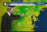
showers and thunderstorms with heavy rain embedded in southwest pennsylvania and about to clip northern west virginia. i think this was live through western maryland and the potomac highlands early this morning. we will keep an eye on the rain as it moves east. frostburg is 76 degrees, 64 in berkeley springs and inwood. 66 in frederick 71 in la plata 74 degrees in arlington. on our way to about 100 this afternoon. it will be hot and sticky. get the sprinkler going to keep cool through the afternoon. it will feel like 105-109 when you factor in the humidity. that's why we have the heat advisory in effect from noon until 8:00 p.m. there is the extended forecast. mid 90's tomorrow, 96. close to about 90 on the weekend. slight chance of storms today through saturday. >> no issues in virginia. that's good news. 95 between richmond and baltimore, everything running in our favor. in pretty good shape is traffic on 66 between centreville and the beltway. normal stuff on the greenway, the dulles toll road, and 270 between father hurley boulevard and the beltway is good, but we are taking you to a picture of 2
showers and thunderstorms with heavy rain embedded in southwest pennsylvania and about to clip northern west virginia. i think this was live through western maryland and the potomac highlands early this morning. we will keep an eye on the rain as it moves east. frostburg is 76 degrees, 64 in berkeley springs and inwood. 66 in frederick 71 in la plata 74 degrees in arlington. on our way to about 100 this afternoon. it will be hot and sticky. get the sprinkler going to keep cool through the...
192
192
Jul 27, 2012
07/12
by
WTTG
tv
eye 192
favorite 0
quote 0
what we've been watching come out of northern west virginia has scattered out. there might be a little something in southern prince george's county into calvert. continuing to move east at 25 miles an hour and nothing too severe. over to sentinel radar now because we've also been watching the baltimore area where we continue to have a flash flood warning until 2 a.m. the activity has moved toward the chester town area. heavy rain is being produced by that and maybe some winds gusting to 40 or 50. there's been tree damage in that region. we watched the whole line. it was very bad up through pennsylvania and new york state, about 400 reports of wind damage up there. what i want you to see as this goes in motion, notice how the first part of this line is weakening out and moving. we get a little break except for our activity here and there's another batch coming through west virginia. we get in closer on this. this will probably also weaken out and cross our area in the overnight hours. we'll keep scattered showers and thunderstorms in the forecast overnight. the s
what we've been watching come out of northern west virginia has scattered out. there might be a little something in southern prince george's county into calvert. continuing to move east at 25 miles an hour and nothing too severe. over to sentinel radar now because we've also been watching the baltimore area where we continue to have a flash flood warning until 2 a.m. the activity has moved toward the chester town area. heavy rain is being produced by that and maybe some winds gusting to 40 or...
321
321
tv
eye 321
favorite 0
quote 0
we're getting some lines of some pockets of heavy downpours here from northern west virginia all of theay across the panhandle of west virginia into northern maryland, eastern shore, around the atlantic beaches getting some heavy downpours. a lot of heavy lightning there. right around washington, just light rain in the immediate suburbs and the district, but farther to our south, southern maryland, charles county into prince william county, too, near fredericksburg getting some moderate downpours with some thunder and lightning. low to mid-70s throughout most of the region this morning, near 70 shenandoah valley into the mountains. here's your "day planner." some occasional showers, a little thunder and lightning through noontime, then a smaller chance of that the rest of the afternoon, remaining cloudy and humid, highs upper 80s. i'll be back in ten minutes with another update and a look at your seven-day outlook for the rest of the week. danella's here now with a look at traffic. good morning. >> good morning, and thanks, tom. great news if you're traveling northbound gw parkway. had
we're getting some lines of some pockets of heavy downpours here from northern west virginia all of theay across the panhandle of west virginia into northern maryland, eastern shore, around the atlantic beaches getting some heavy downpours. a lot of heavy lightning there. right around washington, just light rain in the immediate suburbs and the district, but farther to our south, southern maryland, charles county into prince william county, too, near fredericksburg getting some moderate...
164
164
Jul 26, 2012
07/12
by
WTTG
tv
eye 164
favorite 0
quote 0
tornado warnings and these extend from new york city through southern pennsylvania and into northern west virginia and all along eastern ohio. the line is slowly sinking to the north and some of the model guidance wants to suggest that it should weaken into the area. when we have this kind of tropical humidity and high heat, i would certainly expect the storms to be strong. they're now moving into western maryland. i wanted you to see a second potentially stronger line as it looks on radar right now and that is also going to have to be watched and looks to be more energized as it will probably move in this direction as well and we're going to watch for these, 8, 9:00 and later, keep a chance of a shower or thunderstorm in the forecast and into the overnight hours and probably during the day tomorrow as well. no record today, but we did hit 100. dulles, you broke a record, 98 degrees and actually tieing the record from no one 66. bwi marshal, nice and tropical at everyone in degrees and we're still at 97. quantico, still 101 and annapolis, 92 and talk about the heat index. this is how it feel when
tornado warnings and these extend from new york city through southern pennsylvania and into northern west virginia and all along eastern ohio. the line is slowly sinking to the north and some of the model guidance wants to suggest that it should weaken into the area. when we have this kind of tropical humidity and high heat, i would certainly expect the storms to be strong. they're now moving into western maryland. i wanted you to see a second potentially stronger line as it looks on radar...
134
134
Jul 10, 2012
07/12
by
WUSA
tv
eye 134
favorite 0
quote 0
the air has gotten a little drier across western maryland, parts of northern west virginia, northern , northern virginia but around here still on the sticky side. might see a spotty shower this afternoon. here's a look at your day planner. temperatures starting in the 70s for most of us with a few 60s. we'll be 80 at 9:00. 86 by noon with a high around 87, 88 degrees. again that spotty shower this afternoon. let's go to monika with time saver traffic. >>> no problems on the beltway here on the outer loop at route 5 branch avenue but on the outer loop at route 4, there is an accident just reported. this one is along the right side of the road. again outer loop at route 4 pennsylvania avenue. i'll have more information on that coming up in my next report at 5:48. >> thank you, monika. >>> i've been combing through the day's daily deals, e-mails and retailer websites to find you deep discounts and i have some great ones today. groupon has an online deal with the "new york times." you're going to pay just $1 and you're going to get an eight- week digital subscription to the times. this is
the air has gotten a little drier across western maryland, parts of northern west virginia, northern , northern virginia but around here still on the sticky side. might see a spotty shower this afternoon. here's a look at your day planner. temperatures starting in the 70s for most of us with a few 60s. we'll be 80 at 9:00. 86 by noon with a high around 87, 88 degrees. again that spotty shower this afternoon. let's go to monika with time saver traffic. >>> no problems on the beltway...
258
258
Jul 19, 2012
07/12
by
WMAR
tv
eye 258
favorite 0
quote 0
three to four inches of rain in the northern west virginia area.hink we'll see tough weather today. the northwestern coast. a cool flow from the bay area to eureka. anything south of the bay, you >> oh, so much change here at the set. all that weather was brought to you by folger's. >> if they only knew what went on. >>> flying high. tom cruise all smiles. his arms wrapped around suri. the "mission impossible" musing plays again. new details on the day out and the reported high-speed chase from the paps. ( telephone rings ) hi, honey. how's the camping trip? well, kids had fun, but i think i slept on a rock. what are you doing? having coffee. ah, sounds good! i thought you'd say that. ah. ♪ the best part of wakin' up... ♪ you're the best! wake up to the mountain grown aroma of folgers. ♪ ... is folgers in your cup! celebrate the biggest sale of the year. the 25th anniversary sale and sweepstakes at petsmart. save up to 25% on thousands of items, and don't miss big savings on your cat's favorite brands of canned food during our canapalooza event. on
three to four inches of rain in the northern west virginia area.hink we'll see tough weather today. the northwestern coast. a cool flow from the bay area to eureka. anything south of the bay, you >> oh, so much change here at the set. all that weather was brought to you by folger's. >> if they only knew what went on. >>> flying high. tom cruise all smiles. his arms wrapped around suri. the "mission impossible" musing plays again. new details on the day out and the...
191
191
Jul 26, 2012
07/12
by
WUSA
tv
eye 191
favorite 0
quote 0
thunderstorms this morning with a lot of lightning in southwestern pennsylvania, parts of northern west virginiajust getting into garrett county. going to switch the view here. we'll lose the lightning and show you the intensity of the radar echoes. approaching the turnpike n. is garrett county so it's 068 moving east. cumberland, flint stone, you get the idea. hagerstown in a couple of hours could head your way. this may slip down toward romney and berkley springs and keyser so you folks in the west virginia panhandle will have to watch it as well. temps in the 60s. haymarket has dipped into the mid-60s at 65. scott over at andrews, 69 degrees. columbia 68. we've got 72 in arlington. outside on our michael & son weather camera, skies starting to brighten. sunrise about 6:05 this morning. dew point upper 60s. it is getting muggy out there with the humidity at 76%. so we've got lots of storms well north of us. this cluster of storms in pennsylvania popped from a dying area in ohio. it's -- it got reenergized this morning. we'll have to watch northern maryland. pennsylvania today really under the
thunderstorms this morning with a lot of lightning in southwestern pennsylvania, parts of northern west virginiajust getting into garrett county. going to switch the view here. we'll lose the lightning and show you the intensity of the radar echoes. approaching the turnpike n. is garrett county so it's 068 moving east. cumberland, flint stone, you get the idea. hagerstown in a couple of hours could head your way. this may slip down toward romney and berkley springs and keyser so you folks in...
308
308
tv
eye 308
favorite 0
quote 0
clouds gathering across areas of northern west virginia and i think more clouds later today with the possibility of an isolated storm or two. just like last night and the night before that, it could bring high winds to the storm and frequent lightning. high temperature today maxing out at 94. actually maxing out at 100 degrees later today. as far as tonight goes, 9:00, 11:00 p.m., temperatures will still be quite high at 92 by 9:00 p.m. and plenty warm after a very hot and oppressive day, 86 at 11:00 p.m. and instead of starting to tomorrow in the 70s where it would be nice and comfortable, we'll be starting the upper 70s to around 80 degrees. we'll take another look at the seven-day forecast coming right up. back to you. >> thank you, veronica. >>> we're following a developing story a in italy right now. the captain of the wrecked cruise liner was released from house arrest. fran ches co is accused of causing that accident on january 13th. 30 people died and 2 are still missing and presumed dead. he can leave his house, but he cannot leave his hometown. a trial date has not been set
clouds gathering across areas of northern west virginia and i think more clouds later today with the possibility of an isolated storm or two. just like last night and the night before that, it could bring high winds to the storm and frequent lightning. high temperature today maxing out at 94. actually maxing out at 100 degrees later today. as far as tonight goes, 9:00, 11:00 p.m., temperatures will still be quite high at 92 by 9:00 p.m. and plenty warm after a very hot and oppressive day, 86 at...
218
218
Jul 18, 2012
07/12
by
WRC
tv
eye 218
favorite 0
quote 0
it includes from right in washington to points north across much of maryland and northern virginia into west virginia. this is the severe risk zone. looks like the chance for any strong storms between 5:00 p.m. and 10:00 p.m. by 9:00, it's going to be getting hot. it will be up around 90. hazy sunshine. hot and humid by noontime for your lunch hour. a few clouds popping up. we'll be in the low to mid 90s by then. then, yes, once again, peeking near 100 degrees by mid afternoon. then chance of some showers and storms coming in after that. when that happens we'll drop quickly back down to 90 and even some of the heavier downpours. temperatures could drop into the 70s. when that. has, by late afternoon and evening hours. tomorrow morning, down by the mid 70s. another hot and humid day but not as hot. low to mid 90s. a lot of clouds around. likely afternoon showers and thunder showers. right now a change in the forecast. looks like we might have more showers and thunder showers lingering into friday. yesterday didn't look like that was going to happen but there may be a low pressure forming alon
it includes from right in washington to points north across much of maryland and northern virginia into west virginia. this is the severe risk zone. looks like the chance for any strong storms between 5:00 p.m. and 10:00 p.m. by 9:00, it's going to be getting hot. it will be up around 90. hazy sunshine. hot and humid by noontime for your lunch hour. a few clouds popping up. we'll be in the low to mid 90s by then. then, yes, once again, peeking near 100 degrees by mid afternoon. then chance of...
205
205
Jul 10, 2012
07/12
by
WRC
tv
eye 205
favorite 0
quote 0
west of fredericksburg to charlottesville. a couple of other showers in the northern neck of virginia, st. mary's county, a few passing showers moving east. north of there, partly cloudy and around that region, north of washington, in the 60s in montgomery, frederick county. and the northern panhandle of west virginia and much of the shenandoah valley. a pleasant start this morning. prince georges county, near 70, arlington and fairfax, and mid and ee eer upper 70s, not too h. a beautiful morning under way and we get into the middle of the day. it will get into the low to mid 80s, but not too uncomfortably humid. we'll have a possibility of a an isolated storm mid to late afternoon. south of the metro area and before that, we have to reach the upper 80s to mid 80s by early evening, by dawn tomorrow, in the 60s throughout much of the region, with afternoon highs in the mid and upper 80s woens, partly sunny tomorrow. partly sunny on thursday. small chance of isolated showers, mainly south of the metro area, and then on friday, a greater chance of showers and storms around much of the region,
west of fredericksburg to charlottesville. a couple of other showers in the northern neck of virginia, st. mary's county, a few passing showers moving east. north of there, partly cloudy and around that region, north of washington, in the 60s in montgomery, frederick county. and the northern panhandle of west virginia and much of the shenandoah valley. a pleasant start this morning. prince georges county, near 70, arlington and fairfax, and mid and ee eer upper 70s, not too h. a beautiful...
227
227
Jul 20, 2012
07/12
by
WRC
tv
eye 227
favorite 0
quote 0
it starts at noon, continues all the way into tonight, covers northern virginia, the district and east and west virginia. temperatures right now in the 70s to near 80 degrees and reagan national now at 79 and highs reaching low to mid-80s and when we get in the next two to three hours and then after that some of the heavier downpours later this afternoon, tonight, improving news for the weekend. next week starting off, heat and humidity maybe afternoon storms but a break from the heat and humidity mid-week. that's the way it looks. barbara? >> thank you, tom. >>> a member of congress thinks d.c. should be able to tax commuters who drive or ride into the city every morning. here's a live look at commuter traffic this morning. house republican darrell issa says he wants to hold a hearing on the possibility of a commuter tax. because of home rule, d.c. is the only place in the country that can't levee that kind of tax. issa says he's not necessarily supporting the idea, but says he thinks it's a bad idea to give workers an incentive to live in maryland or virginia but work in d.c. >>> and taking m
it starts at noon, continues all the way into tonight, covers northern virginia, the district and east and west virginia. temperatures right now in the 70s to near 80 degrees and reagan national now at 79 and highs reaching low to mid-80s and when we get in the next two to three hours and then after that some of the heavier downpours later this afternoon, tonight, improving news for the weekend. next week starting off, heat and humidity maybe afternoon storms but a break from the heat and...
278
278
Jul 13, 2012
07/12
by
WRC
tv
eye 278
favorite 0
quote 0
storm4 radar, patches of green, some sprinkles in northern virginia and west virginia now. and later today, we might have a lingering sprinkle by 9:00. a greater chance perhaps by later this afternoon of a passing shower. before then, cloudy and up into the mid 80s. still not too humid but humidity increases tonight for your friday evening along with the increasing chance of a passing shower. low 70s by midnight. your seven-day outlook, a look at the weekend and next week. that's in ten minutes. how is traffic now? >> still good in our area. it's friday. and it's early in the morning. if you're traveling along route 50 from annapolis and making your way on 301, no issues. let me give you a live look on that. very light volume as you zoom inbound all of the way to new york avenue. no issues in either direction. nice and clear. if you're taking the rails, looking good. no reported right now. >>> there are no shortage of rain here by the severe drought gripping most of our country could still have a big i'm pat on you. >>> plus, not everything about our olympic team is is all
storm4 radar, patches of green, some sprinkles in northern virginia and west virginia now. and later today, we might have a lingering sprinkle by 9:00. a greater chance perhaps by later this afternoon of a passing shower. before then, cloudy and up into the mid 80s. still not too humid but humidity increases tonight for your friday evening along with the increasing chance of a passing shower. low 70s by midnight. your seven-day outlook, a look at the weekend and next week. that's in ten...
294
294
tv
eye 294
favorite 0
quote 0
virginia. most locations are just in the low to mid-70s. in fact, some of these pockets in green are in the 60s. that includes parts of northern maryland, western maryland, westirginia and the highlands there, central shenandoah valley, too, only in the 60s this morning. what a wonderful break from the intense heat we've had the last number of days. now it's all settled in washington, as a live view from our hd city camera. sunrise was at 5:51, just occurring now, and as we get to noontime, we'll be in the mid-80s and a likelihood of a few more passing showers, maybe some thunder and lightning between now and noon, but after that, we should settle down. highs reaching upper 80s by mid-afternoon under a mostly cloudy sky. still going to be steamy humidity, though, and just a smaller chance of an additional shower or thunder shower later this afternoon. here's your four-day forecast. overnight tonight just some clouds around, down near 70 by dawn tomorrow. then another chance maybe of a morning shower or ths thunder shower, but maybe a little greater chance during the afternoon and evening on tuesday and highs tomorrow just into the mid-80s. then wednesday look
virginia. most locations are just in the low to mid-70s. in fact, some of these pockets in green are in the 60s. that includes parts of northern maryland, western maryland, westirginia and the highlands there, central shenandoah valley, too, only in the 60s this morning. what a wonderful break from the intense heat we've had the last number of days. now it's all settled in washington, as a live view from our hd city camera. sunrise was at 5:51, just occurring now, and as we get to noontime,...
190
190
Jul 19, 2012
07/12
by
WTTG
tv
eye 190
favorite 0
quote 0
west virginia of 911. the fcc calls the problems "stemmatic in northern virginia and in west virginia." >>> more trouble fortem. a line of buses linked to a series of fires has been pulled from service now. that means ride on is running on a modified schedule today. the latest fire was yesterday and the bus was out of service at the time. in the last three years have have been at least seven fires on the fleet of buses made by champion international. >>> meantime, there is good news for metro riders. they could finally see a smoother ride after several days of delays. the transit agency says it finally found the source of the computer issues that brought the system to a halt twice over the weekend. metro blames a hardware failure and says the broken module has now been replaced, but they are still investigating what caused the failure. >>> george zimmerman is speaking out. it's the first time since his arrest for the killing of trayvon martin and he's exclusively talking to fox news. >> he sat down in an interview with fox's sean hannity and he says he is praying for trayvon's parents. wisdom martin is back
west virginia of 911. the fcc calls the problems "stemmatic in northern virginia and in west virginia." >>> more trouble fortem. a line of buses linked to a series of fires has been pulled from service now. that means ride on is running on a modified schedule today. the latest fire was yesterday and the bus was out of service at the time. in the last three years have have been at least seven fires on the fleet of buses made by champion international. >>> meantime,...
261
261
Jul 20, 2012
07/12
by
WRC
tv
eye 261
favorite 0
quote 0
it covers all of the way of northern virginia and east and west virginia, the district and much of marylandis for the possibility of heavy downpours that may cause some localized flooding. and we could get a passing shower by mid morning. we'll be in the upper 70s by then. and around noontime, too. have an umbrella handy for your lunch hour. we could have downpours beginning to occur there. but the likelihood of the flooding rains is during the afternoon into tonight. we'll be reaching mid 80s before they do get going. if you're driving along, hey hi water, do not attempt to drive through high water. not only will your vehicle stall out you will probably ruin the engine in your car. we will have the heavy downpours with thunder and lightning likely through this friday evening. if you have plans to go out tonight, be aware of that. tomorrow, cloudy, near 80. much cooler. small chance of a shower. maybe an afternoon thunder shower sunday. small chance of that. might get storms the first part of next week. back into the 90s. more comfortable weather mid week next week. how is traffic? >> good
it covers all of the way of northern virginia and east and west virginia, the district and much of marylandis for the possibility of heavy downpours that may cause some localized flooding. and we could get a passing shower by mid morning. we'll be in the upper 70s by then. and around noontime, too. have an umbrella handy for your lunch hour. we could have downpours beginning to occur there. but the likelihood of the flooding rains is during the afternoon into tonight. we'll be reaching mid 80s...
223
223
Jul 4, 2012
07/12
by
WUSA
tv
eye 223
favorite 0
quote 1
feel good about your decisions. >>> a few showers and storms across northern maryland and west virginiaay, expecting a very hot, humid day, heat advisory from noon until 9:00. temperatures topping out in the upper 90s. a couple of storms in spots this afternoon. anything that pops could be on the strong side. full forecast coming up in five minutes. here's monika with timesaver traffic. >> reporter: the situation continues on the northbound side of the bw parkway where park police are on the scene of a fatality. pedestrian struck. no asking assess from 495. back to you andrea. >> we have been coping through the -- combing through the daily deals. how about a dot for your ipod or iphone? -- a dock. best buy is selling the mental rex party cd sound system for $59.99. that is 63% off the normal asking price and this comes with free shipping. >>> river riders in harper's ferry, west virginia have a great summer deal a two and a half hour whitewater tubing trip for $43. this comes complete way cookout lunch, two beers and the t-shirt. >>> 64% off samsung's 23-inch led monitor. e-bay is selli
feel good about your decisions. >>> a few showers and storms across northern maryland and west virginiaay, expecting a very hot, humid day, heat advisory from noon until 9:00. temperatures topping out in the upper 90s. a couple of storms in spots this afternoon. anything that pops could be on the strong side. full forecast coming up in five minutes. here's monika with timesaver traffic. >> reporter: the situation continues on the northbound side of the bw parkway where park...
181
181
Jul 19, 2012
07/12
by
WTTG
tv
eye 181
favorite 0
quote 0
the fcc all these problems, quote, systematic in northern virginia and west virginia. >>> let's checkn with tucker and get the latest on our forecast. fortunately, we haven't seen anything like we saw june 29th. >> we always hope we don't. no promises. i mean you know, any time we are talking about summertime in washington, any particular storm has potential to cause some problems. yesterday, we had some issues. today, i don't think the storms will be quite as strong or as numerous but with the front around, we have temperatures expected to be about 90. we have agot some fuel to drive the storms. we'll see what happens later this afternoon. in other words, they are back in the forecast unfortunately. >> they take on a life of their own, it seems like. >> they can this time of year. >> and they make people nervous too. >> yes, they do. in fact, let's get to -- >> make the cameras nervous. >> it sure does. >> we don't want you to forget who you're watching. >> let's go right to the numbers. the high temperature yesterday at reagan national was 101 degrees. dulles set a new record at 101
the fcc all these problems, quote, systematic in northern virginia and west virginia. >>> let's checkn with tucker and get the latest on our forecast. fortunately, we haven't seen anything like we saw june 29th. >> we always hope we don't. no promises. i mean you know, any time we are talking about summertime in washington, any particular storm has potential to cause some problems. yesterday, we had some issues. today, i don't think the storms will be quite as strong or as...
352
352
Jul 18, 2012
07/12
by
WRC
tv
eye 352
favorite 0
quote 0
we've got more lightning too showing up in areas around frostburg and just off to the west in northern areas of west virginia. the line right now making its way southward but we've also got some individual cells that have jumped out ahead of that line, which is why we've got the warnings coming up now for d.c. and prince george's county. but for owings mills, you can see that area being hit in the next ten minutes with high winds, downpours toward eldersburg in the next 15 minutes and on toward randallstown in the last 41. and again, hail a possibility as well as the possibility of some high winds too coming into the area. this other cell that you see here from veinsville in the next 38 minutes with heavy rain and on tart waterbury in the next 59 minutes. and then we've got our temperatures, of course, that topped out at 101 degrees. that's the reason why we're seeing such strong storms again come to our area, because we had the high heat today, we had a tremendous amount of moisture. we've also got this weather system that is sinking southward so the potential of storms again tomorrow. but at 101, that's no
we've got more lightning too showing up in areas around frostburg and just off to the west in northern areas of west virginia. the line right now making its way southward but we've also got some individual cells that have jumped out ahead of that line, which is why we've got the warnings coming up now for d.c. and prince george's county. but for owings mills, you can see that area being hit in the next ten minutes with high winds, downpours toward eldersburg in the next 15 minutes and on toward...
150
150
Jul 30, 2012
07/12
by
WMAR
tv
eye 150
favorite 0
quote 0
then down lear in northern virginia, a couple of storms west of the virginia suburbs. you have to get almost halfway to winchester to find that active weather. around the immediate baltimore area conditions sitting clear. that was not the case earlier today. one of those rare days where you go from cloud cover top showers -- to showers. we saw brighter conditions overtake the city as we worked into the afternoon. how about a look at laurel aboard the football field getting greener now that we had decent rain and skies clearing off nicely after morning rain and ocean city always a place to be in the last days of july. as we look toward the first days of august, pretty good beach weather beach side. let's take a look at the overall setup. 85 at airport. humidity moderate to high. winds are out of the east. that's holding temps down a it ll bit so. 90 for a high today at the inner harbor. hot, yes, but not the extreme heat we often see at the tail end of the month. the moisture levels, the humidity values are about as high as they ge. typically 70 or so. we can get dew po
then down lear in northern virginia, a couple of storms west of the virginia suburbs. you have to get almost halfway to winchester to find that active weather. around the immediate baltimore area conditions sitting clear. that was not the case earlier today. one of those rare days where you go from cloud cover top showers -- to showers. we saw brighter conditions overtake the city as we worked into the afternoon. how about a look at laurel aboard the football field getting greener now that we...
179
179
tv
eye 179
favorite 0
quote 0
power company official in northern west virginia told us that three transmission towers, those big kindthat transmit power lines in rural areas, three of those came down. we have a picture of one of those mangled towers. those have been replaced by temporary towers so the lines are back up. but huge infrastructure challenges. i talked to a local resident, his name is casey robinson, about what people are going through in dealing with and some of the things they take for granted that they don't have now. >> what kind of problems have the power outages caused for your neighborhood and others here? >> things you never thought of actually, other than the obvious, that is throwing a way a lot of food. we're also finding out the conveniences you took so much for granted are gone. a lot of folks in the neighborhoods have been nervous about potential looting and don't have any power to run their security systems. >> reporter: so not only heat, powerht outages, people trying stay cool but they have to worry about security systems and keeping an eye on their homes. maybe if they've gone somewher
power company official in northern west virginia told us that three transmission towers, those big kindthat transmit power lines in rural areas, three of those came down. we have a picture of one of those mangled towers. those have been replaced by temporary towers so the lines are back up. but huge infrastructure challenges. i talked to a local resident, his name is casey robinson, about what people are going through in dealing with and some of the things they take for granted that they don't...
247
247
Jul 4, 2012
07/12
by
WJLA
tv
eye 247
favorite 0
quote 0
in west virginia and northern maryland. it will drop into western maryland and west virginia. potomac highlands. there's a look at the rain breaking up into the panhandle of west virginia. hagerstown and an north of frederick and into it emmett's bertrand thurmont, there's been rain off and on. one downpour moving into hagerstown at this time. beneficial rain, actually, early this morning. 74 in arlington, 74 la plata, 72 in strasbourg, virginia. there's a heat advisory in effect today starting at noon until 9:00 p.m. for the metro area, and down the 95 corridor. it will feel like 100 degrees to 105. 91 degrees by noon. 97 will be are higher temperature -- our high temperature. when it rains, the air will cooldown briefly. we will have scattered storms popping throughout the day as early as 11:00 a.m. all the way through about sunset. there's a slight chance one or two storms could last through the fireworks time. a very slight chance. maybe not all the storms will be over by then. warm and humid for the fireworks upper 80s. we are in the reach of 100 today all the way through
in west virginia and northern maryland. it will drop into western maryland and west virginia. potomac highlands. there's a look at the rain breaking up into the panhandle of west virginia. hagerstown and an north of frederick and into it emmett's bertrand thurmont, there's been rain off and on. one downpour moving into hagerstown at this time. beneficial rain, actually, early this morning. 74 in arlington, 74 la plata, 72 in strasbourg, virginia. there's a heat advisory in effect today starting...
241
241
Jul 13, 2012
07/12
by
WRC
tv
eye 241
favorite 0
quote 0
of cloudiness across northern virginia, the district and much of the rest of maryland and still a few sprinkles out in western maryland. the potomac highlands the panhandle of westirginia. right now 83 at reagan national and beginning to hit the low 80s across northern virginia and parts of maryland and under the cloud cover in the shenandoah valley and still getting some of those showers, only in the 70s. cumberland is only at 70 degrees right now. for the rest of the afternoon, a little sunshine breaking up and a slight chance of a shower, will be reaching the mid-80s by midafternoon. a very light, variable wind and back down to near 80 by early this evening. going to the beach this weekend? i'll have your beach forecast. we'll look at your seven-day outlook, as well. >> thank you, tom. >>> d.c. mayor vincent gray is slated for many public events today as he faces calls for his resignation. three council members say the mayor should step down in light of the investigation into his mayoral campaign. pleaded guilty to running $650,000 shadow campaign. last night the mayor acknowledged the probe while accepting a leadership award. he told the crowd he would get t
of cloudiness across northern virginia, the district and much of the rest of maryland and still a few sprinkles out in western maryland. the potomac highlands the panhandle of westirginia. right now 83 at reagan national and beginning to hit the low 80s across northern virginia and parts of maryland and under the cloud cover in the shenandoah valley and still getting some of those showers, only in the 70s. cumberland is only at 70 degrees right now. for the rest of the afternoon, a little...
167
167
Jul 9, 2012
07/12
by
WUSA
tv
eye 167
favorite 0
quote 0
northern loudoun into southern frederick county. this actually stretches all the way in toward jefferson county, west virginia, cross junction, northern frederick county, virginia all moving to the east and a little bit of lightning at 5:22 near the virginia-west virginia border. another stop taking us to huntington county. south of dunkirk, north of prince frederick. even coming out of harrisonburg, culpeper, make fauquier -- maybe fauquier county, orange, you'll see some of that as well. temperatures this morning still warm. they're not in the 80s but the 70s. we'll have highs in the 80s the entire week. right now still wet out there on our michael & son weather camera. 75 at national with a northeast wind at 15. dew point 72. so it is still rather muggy with the rain around. we're seeing a lot of showers and storms stretching from missouri actually to nebraska right through the ohio and ten valleys. -- tennessee valleys. that's the front that came through here and will continue to come through. we'll have the showers and storms with us for a few more hours this morning but looks like the better chance this afternoon will be south o
northern loudoun into southern frederick county. this actually stretches all the way in toward jefferson county, west virginia, cross junction, northern frederick county, virginia all moving to the east and a little bit of lightning at 5:22 near the virginia-west virginia border. another stop taking us to huntington county. south of dunkirk, north of prince frederick. even coming out of harrisonburg, culpeper, make fauquier -- maybe fauquier county, orange, you'll see some of that as well....
180
180
Jul 17, 2012
07/12
by
WRC
tv
eye 180
favorite 0
quote 0
pan hand of west virginia and central west virginia and northern central shenandoah valley in the 60s this morning. it's not going to last much longer as we have a rapid heating. upper 80s by 9:00. by noon, low 90s. yes, hovering near 100 degrees by mid afternoon. it's going to feel like 105 with the humidity. and we'll have hey i have sunshine. a few clouds popping up late afternoon. by 6:00, back down to the mid 90s. sun rise is at 5:57. sunset, 8:31. i'll be back in ten minutes. danella is here now with a look the traffic. >>> looks like road work is affecting you as you look at road work. you should get by each work zone without any problem. outer loop as you approach new hampshire avenue, two right lanes are blocked at this time. just that entire way you're going to see the right lanes blocked. again, stick to the left. you should be okay. heading to virginia, also on the outer loop of the dulles toll road. only the right lane gets by the work zone there. as you continue towards i-66, only the right lane gets you by the work zone there as well. both of those should be any moment
pan hand of west virginia and central west virginia and northern central shenandoah valley in the 60s this morning. it's not going to last much longer as we have a rapid heating. upper 80s by 9:00. by noon, low 90s. yes, hovering near 100 degrees by mid afternoon. it's going to feel like 105 with the humidity. and we'll have hey i have sunshine. a few clouds popping up late afternoon. by 6:00, back down to the mid 90s. sun rise is at 5:57. sunset, 8:31. i'll be back in ten minutes. danella is...
285
285
Jul 5, 2012
07/12
by
WJLA
tv
eye 285
favorite 0
quote 0
they stayed to the northwest of town in western maryland and west virginia and northern virginia. overnight around 2:00 21:00 p.m., a few thunderstorms in quantico. and stafford quantico then moved east across the potomac anticipated before made it to st. mary's county. in quantico the measure the wind gust of 68 miles an hour while we were sleeping from that storm. 80 right now in the district, 78 in quantico, 68 in martinsburg and cumberland, 79 in winchester. it's gone to be another hot day. that's all the way into the weekend. on monday, temperatures will drop a little. there's a heat advisory from noon until 8:00 for the majority of our viewing area, especially in the metro area and the 95 corridor because it will feel like 100 or so. 99 or more daily all the way to the weekend. i think we will make it up to 101 or so on saturday. the record is 102. upper 80s by monday with a pleasant shift in the weather pattern. that's the way it looks right now. we could be talking mid '80s by the middle of next week. let's go to steve hershorn. trafficked >> we will take a look at 395. li
they stayed to the northwest of town in western maryland and west virginia and northern virginia. overnight around 2:00 21:00 p.m., a few thunderstorms in quantico. and stafford quantico then moved east across the potomac anticipated before made it to st. mary's county. in quantico the measure the wind gust of 68 miles an hour while we were sleeping from that storm. 80 right now in the district, 78 in quantico, 68 in martinsburg and cumberland, 79 in winchester. it's gone to be another hot day....
218
218
Jul 21, 2012
07/12
by
WBAL
tv
eye 218
favorite 0
quote 0
now from the eastern shore northwestward out into carroll county, and there's more to the west in northern virginia and west virginia as well, and it's drifting in, traveling along the north edge of that front. so, yes, we still have rain in the forecast today. we'll try to salvage tomorrow. it might be a 50-50 this weekend. i'll talk about it coming up with the insta-weather. >> now to our big story, detames on the horrific massacre in aurora, colorado, continue to unfold this morning. 12 people were killed, more than 50 injured during a shooting spree at the premiere of the new batman knewee, "the dark knight rises." >> this morning, community searches for clues about how and why this massacre happened. we have team coverage this morning, and we begin with 11 news reporter jay gray. >> i got people running out of the theater that were shot. >> we're learning more tonight about the firestorm unleashed inside this colorado movie theater much >> it's an act that defies description. >> police say 23-year-old james holmes was dressed in full body armor and wearing a gas mask when he burst through an e
now from the eastern shore northwestward out into carroll county, and there's more to the west in northern virginia and west virginia as well, and it's drifting in, traveling along the north edge of that front. so, yes, we still have rain in the forecast today. we'll try to salvage tomorrow. it might be a 50-50 this weekend. i'll talk about it coming up with the insta-weather. >> now to our big story, detames on the horrific massacre in aurora, colorado, continue to unfold this morning....
396
396
Jul 20, 2012
07/12
by
WRC
tv
eye 396
favorite 0
quote 0
includes the district, most of maryland, all of northern virginia and eastern west virginia, potential downpours with some thunder and lightning. watch out for high water. we tell you this i've rye time, do not attempt to drive through high water. not only will you get stranded, you will ruin the engine in your vehicle and we will have that potential flooding all of the way into tonight. and then tomorrow, cloudy, cooler, highs near 80. a small chance of a patszing shower. sunday, a break might get an afternoon storm. greater)remai cooler, less humid, that's from overnight accident. down. you're going to be redirect fed ogomery slot duknoruupr08 i-95 as youg thank duke northbound. aaron and erika? >> danella, thank you for that. >>> again, update you on the breaking news coming out of aurora, colorado, near denver. looking at cell phone video outside a movie theater there where a ris happened confirm deadd 12: denver time as there was a screening of "the dark knight rises." 14 people confirmed dead in a shooting inside that movie theater. ed ] being taken to different area young hospit
includes the district, most of maryland, all of northern virginia and eastern west virginia, potential downpours with some thunder and lightning. watch out for high water. we tell you this i've rye time, do not attempt to drive through high water. not only will you get stranded, you will ruin the engine in your vehicle and we will have that potential flooding all of the way into tonight. and then tomorrow, cloudy, cooler, highs near 80. a small chance of a patszing shower. sunday, a break might...
177
177
Jul 27, 2012
07/12
by
WUSA
tv
eye 177
favorite 0
quote 0
and find out what the catch is. >> a dog fight between a northern virginia restaurant and a west virginiae house. hear from both sides in this dispute over a name. >> and before you grab the keys let's check on the commute now, monika samtani over to you. >> northbound i-95 a minor incident on the shoulder near lorton. it's moved on and caused a tiny delay here but no big deals helding for springfield and the beltway. i'll be back with more traffic coming up in my next report, at 6:30. you're watching 9news now. >>> welcome back. 6:29. your weather first on this thread morning. tgif is another humid sticky morning. not as bad as though as yesterday and it's not going to be as hotted a yesterday. still going to be hot and mid 90s. 95 or so and we have again a threat of storms, here's the day planner we have temperatures this morning starting in the 70s. pretty sky here in northwestern d.c. with some of the clouds mixing in. 91 by moon. mix of clouds and sun and then this afternoon, 95. 93 by 5:00. and by then, we'll have a couple of storms mainly south of town. yesterday evening had the bi
and find out what the catch is. >> a dog fight between a northern virginia restaurant and a west virginiae house. hear from both sides in this dispute over a name. >> and before you grab the keys let's check on the commute now, monika samtani over to you. >> northbound i-95 a minor incident on the shoulder near lorton. it's moved on and caused a tiny delay here but no big deals helding for springfield and the beltway. i'll be back with more traffic coming up in my next report,...
185
185
Jul 9, 2012
07/12
by
WUSA
tv
eye 185
favorite 0
quote 0
thunderstorms lining up in northern virginia and maryland, east and west virginia going over to the delmar have with the lightning on top of it. quite of it -- quite a different it coming out of southern maryland toward the eastern shore. lesser amounts of lightning up to the north although we're still seeing moderate to heavy rain frederick east over toward westminster. a little lightning there through central and northern montgomery county tracking into howard county. back toward charles town and even toward northern frederick county. in jefferson county, west virginia, there it is on i-81, berkley springs we're seeing some of the showers come out east here south of more continuesburg north of winchester. we'll head south toward virginia as well. the shenandoah valley coming into the park. there's amissville coming toward warren tun, culpeper all moving toward the east. watch out for some of this moderate to heavy rain. calvert county it's generally in the bay affecting the eastern shore. your temperatures this morning are running in the low to mid- 70s out there. so a lot more comfortab
thunderstorms lining up in northern virginia and maryland, east and west virginia going over to the delmar have with the lightning on top of it. quite of it -- quite a different it coming out of southern maryland toward the eastern shore. lesser amounts of lightning up to the north although we're still seeing moderate to heavy rain frederick east over toward westminster. a little lightning there through central and northern montgomery county tracking into howard county. back toward charles town...
183
183
Jul 11, 2012
07/12
by
WRC
tv
eye 183
favorite 0
quote 0
maybe near 90 farther west across northern virginia. then by late evening, low 70s. i'm back with your seven-day outlook in ten minutes. danella is here with a look at traffic. >> traveling 295 in maryland, things look good. travel lanes open heading between baltimore and the capital beltway. travel speeds southbound, 67 miles per hour approaching 197. over to i-95, a live look passing 198 southbound as well as if you are traveling northbound. no issues to report. looks like my camera is just adjusting. travel speed is 66 miles per hour from route 216 to the beltway. that drive just taking nine minutes. i'm back in ten with another look at your traffic. >> 4:42 now. 70 degrees out there. still ahead, one city's drastic measure to make their budget work that has employees seeing red. >>> an inside look at london's olympic village and how it helped transform >>> the walls seem to be closing around seven-time tour de france winner lance armstrong. the doping agency has issued lifetime sports bans to three of armstrong's former sports members. they worked for him between
maybe near 90 farther west across northern virginia. then by late evening, low 70s. i'm back with your seven-day outlook in ten minutes. danella is here with a look at traffic. >> traveling 295 in maryland, things look good. travel lanes open heading between baltimore and the capital beltway. travel speeds southbound, 67 miles per hour approaching 197. over to i-95, a live look passing 198 southbound as well as if you are traveling northbound. no issues to report. looks like my camera is...
299
299
Jul 24, 2012
07/12
by
WRC
tv
eye 299
favorite 0
quote 0
we widen out here the severe thunderstorm watch, no longer in affect for extreme northern virginia, the panhandle of west virginia and most of maryland knew out of that severe thunderstorm watch. so some good news there things are starting to calm down. not only are they going to calm down as the hot weather brought in those storms but things are going to get beautiful, by tomorrow morning, going to walk outside to a completely different atmosphere. wither going to see low humidity, cooler temperatures, some going to be nice. plenty of sunshine. can that last a little while, doug? my answer is no the heat moves back in, not just the heat but potential record-breaking heat. we could get close to the record in d.c. the record shy 103. right now, i got us going to about 101 with the heat index, about 105 to 110. thursday looking like a very hot day but it is going to be short lived. we have another front to the north that will break that heat as we head to the weekend. this evening, scattered storms, some severe down to the south. but again this threat is diminishing now temperature's 84 to 89. tomorrow mor
we widen out here the severe thunderstorm watch, no longer in affect for extreme northern virginia, the panhandle of west virginia and most of maryland knew out of that severe thunderstorm watch. so some good news there things are starting to calm down. not only are they going to calm down as the hot weather brought in those storms but things are going to get beautiful, by tomorrow morning, going to walk outside to a completely different atmosphere. wither going to see low humidity, cooler...
283
283
tv
eye 283
favorite 0
quote 0
got this conveyor belt of showers and thunder and lighting in moving west to east across west virginia, northern virginia into maryland. right now around the metro area, just light rain, but these areas in red, northern montgomery, western howard into frederick county getting heavy downpours. watch out. some creeks and streams may be coming out of their banks there, thunder and lightning with that, heading east. farther south, moderate showers and thunder and lightning from southern maryland into calvert county, charles county. there's another area of thunder and lightning rolling across the shenandoah valley, heading east to the eastern shore where they're getting heavy rain this morning right now. temperatures around the region are in the 70s most locations, near 80 in the cities from washington to annapolis and down the pax river and farther west. low 70s to the 60s out of the mountains. here's your "day planner." by noontime, still a few scattered thunderstorms around, mid-80s by then, then peaking in the upper 80s by mid-afternoon, then a smaller chance moving in, any more storms later this
got this conveyor belt of showers and thunder and lighting in moving west to east across west virginia, northern virginia into maryland. right now around the metro area, just light rain, but these areas in red, northern montgomery, western howard into frederick county getting heavy downpours. watch out. some creeks and streams may be coming out of their banks there, thunder and lightning with that, heading east. farther south, moderate showers and thunder and lightning from southern maryland...
244
244
Jul 12, 2012
07/12
by
WRC
tv
eye 244
favorite 0
quote 0
panhandle of west virginia, much of northern and western maryland and out into west virginia, it's inhe upper 70s now and here is what has been happening over the last several hours. we've had a front that's been stalled out here to our south and this front is gradually sort of creeping a bit north, but it does look like it is going to be dissipating by saturday. as a result, that will allow the humidity to begin to move back in, but, right now, it's the barrier between us and extreme humidity. we do have a lot of sunshine just to our north. just a few streaks of high clouds passing over us now and we will have these clouds in and out across the metro area all into the afternoon, getting a few sprinkles at the atlantic beaches and as we go forward over the next several hours, just a few clouds in and out during the afternoon. wherever you see any color breaking out, that's where we have a chance for some showers and we stay dry here, all the way through the day, much of the day on friday. this is by friday around mid-afternoon to late afternoon. still just a lot of cloudiness coming i
panhandle of west virginia, much of northern and western maryland and out into west virginia, it's inhe upper 70s now and here is what has been happening over the last several hours. we've had a front that's been stalled out here to our south and this front is gradually sort of creeping a bit north, but it does look like it is going to be dissipating by saturday. as a result, that will allow the humidity to begin to move back in, but, right now, it's the barrier between us and extreme humidity....
302
302
Jul 26, 2012
07/12
by
WRC
tv
eye 302
favorite 0
quote 0
west, bringing in the humidity. right now, though, 60s across much of northern virginia, much of maryland and west virginia, but it'soing to be getting more humid as the morning progresses. in addition, there have been a cluster of thunderstorms that have been rapidly developing in pennsylvania, now moving into western maryland, garrett and allegany counties. those storms are moving east quickly, but not severe. they do have quite a bit of lightning with them and some heavy downpours. and if those hold together, and they might, they'll be near the metro area by about 9:00, 10:00 this morning. all these areas in yellow under a severe risk zone. that would generally be between about 4:00 p.m. to 8:00 p.m. tonight is when we could get some stronger storms that might produce some wind damage, and unfortunately, could cause some power outages. before then, though, the areas that don't get any rain will likely climb to near 100 degrees by mid-afternoon. this is your "day planner." in fact, by noontime, might have a few lingering thunder showers coming through, near 90 by then. but most of the afternoon feeling uncomfortab
west, bringing in the humidity. right now, though, 60s across much of northern virginia, much of maryland and west virginia, but it'soing to be getting more humid as the morning progresses. in addition, there have been a cluster of thunderstorms that have been rapidly developing in pennsylvania, now moving into western maryland, garrett and allegany counties. those storms are moving east quickly, but not severe. they do have quite a bit of lightning with them and some heavy downpours. and if...
279
279
Jul 2, 2012
07/12
by
WTTG
tv
eye 279
favorite 0
quote 0
. >>> and some incredible pictures from the storm from west virginia and northern virginia, maryland and the district. send us your storm photosy, and mail us your picture or videos from your. >> i joy phone or droid. send them to myweatherphoto@gmail.com. >>> still ahead, mother nature left a trail of damage behind. next, how to navigate your insurance policy with storm claims. ♪ ♪ ♪ [ male announcer ] everyone likes a bit of order in their life. virtual wallet helps you get it. keep track of spending, move money with a slide, and use the calendar. all to see your money how you want. ♪ . >>> the vicious pop-up storm left a trail of damage and now hundreds of home owners forced to make repairs. -- the confusion that follows a big storm and can you commiserate because you don't have power either. at least you don't have storm damage, the scary part and the part going to last longer. what is your recommendation first off to someone who had a tree fall on their house or car and had some significant wind damage and has to go through what they sudden going to seem like an endless supply o
. >>> and some incredible pictures from the storm from west virginia and northern virginia, maryland and the district. send us your storm photosy, and mail us your picture or videos from your. >> i joy phone or droid. send them to myweatherphoto@gmail.com. >>> still ahead, mother nature left a trail of damage behind. next, how to navigate your insurance policy with storm claims. ♪ ♪ ♪ [ male announcer ] everyone likes a bit of order in their life. virtual wallet...
484
484
Jul 27, 2012
07/12
by
WRC
tv
eye 484
favorite 0
quote 0
the areas in green is some light rain that stretches from the hylands in west virginia across the northern shenandoah valley and frederick county. this is going to past north and west of the metro area. right now though around washington, partly cloudy. mostly clear on the eastern shore and around the bay and northern neck where the temperatures right now are in the upper 70s and low 80s. still very steamy there. closer to washington, all of these areas in yellow, generally in the low to mid 70s. we have a few places dipping into the upper 60s just to the north into northern montgomery county and into carroll county and farther to the howard county getting some temperatures in the 60s as well as the mountains. and the forecast for today, partly sunny. not as hot. probably have more clouds around. afternoon highs reaching the mid 90s. and then it's late afternoon and early even tlag we could get some strong storms. some of the storms could be severe. areas south and east of washington tomorrow afternoon -- rather, this afternoon and into this evening. again tomorrow afternoon we could get s
the areas in green is some light rain that stretches from the hylands in west virginia across the northern shenandoah valley and frederick county. this is going to past north and west of the metro area. right now though around washington, partly cloudy. mostly clear on the eastern shore and around the bay and northern neck where the temperatures right now are in the upper 70s and low 80s. still very steamy there. closer to washington, all of these areas in yellow, generally in the low to mid...
223
223
Jul 8, 2012
07/12
by
WJLA
tv
eye 223
favorite 0
quote 0
another to the south and west across the northern neck of virginia. look at the highs today -- another record-breaking day -- 102 degrees. temperatures have cooled into -- have cooled thanks to the thunderstorms. a full forecast and more details, plus you might have heard a big boom in upper northwest d.c. -- we will talk about a possible lightning strike. >> thank you. pepco customers without power just got their power back on today and now many people are dealing with the power problems again. the current storm is heading northern virginia hardest. dominion of reporting more than 20,000 people without a light ton. >> we will finally break the record heat wave. today proved to be another difficult day for many people. let's get more on how people dealt with this last day of extreme temperatures. >> they're happy to see the heat ago for sure. typically those places would be filled with people wanting to take their dinner outdoors but people have just started to venture outside and high heat has hurt businesses and people's health. even though attempti
another to the south and west across the northern neck of virginia. look at the highs today -- another record-breaking day -- 102 degrees. temperatures have cooled into -- have cooled thanks to the thunderstorms. a full forecast and more details, plus you might have heard a big boom in upper northwest d.c. -- we will talk about a possible lightning strike. >> thank you. pepco customers without power just got their power back on today and now many people are dealing with the power problems...
150
150
Jul 26, 2012
07/12
by
WJLA
tv
eye 150
favorite 0
quote 0
however, off to the north, that is where we have a moderate risk in northern and western relevant parts of west virginiaat is where severe thunderstorms are more likely later on today. the primary effect -- the primary threat is between 4:00 p.m. and 1:00 a.m., primarily gusty wind. so the wind and hale will be the primary threat later on today. 98 degrees is the high temperature in some places, especially south of town where you have more sunshine. a few storms over night to night until about 1:00 a.m. some could be strong to severe. tomorrow afternoon, i think we will spend the day in the mid- 90's. it will still be hot and sticky. we do have a chance of a few strong or severe storms tomorrow as well. the temperature still looks like it will dive down into the upper-70's. >> which you would welcome after a day like today -- into the upper-80's. >> which you would welcome after a day like today. wild horses to to the water. each summer, the volunteer fire department herds of them across the waterway as a prelude to an auction. about 40,000 people also flocked to the area each year to watch them swim. 1
however, off to the north, that is where we have a moderate risk in northern and western relevant parts of west virginiaat is where severe thunderstorms are more likely later on today. the primary effect -- the primary threat is between 4:00 p.m. and 1:00 a.m., primarily gusty wind. so the wind and hale will be the primary threat later on today. 98 degrees is the high temperature in some places, especially south of town where you have more sunshine. a few storms over night to night until about...
355
355
Jul 20, 2012
07/12
by
WRC
tv
eye 355
favorite 0
quote 0
west virginia heading toward the northeast. ahead of that we've got a flash flood watch in effect from noon into tonight and covers the eastern west virginia and all of northern virginia. the district and most of maryland. heavy downpours this afternoon with thunder and lightning that could cause localized flooding. highs reaching the low to mid 80s. that continues into tonight. seven-day outlook in ten minutes. danella, how's traffic? >> still seeing downed wires in glendale, result flg an earlier overnight accident. the wires are down. this say long eastbound green belt road. your road closure is between forbes, mdot is directing traffic in that area. inner loop of the beltway, at green belt road. this is reportedly a disabled vehicle but i is a k. see that looks like a fire truck. police are shheavy on the scene blocking two lanes. you are seeing rubber necking past green belt road. if you're taking the rails, things still look good. >>> the time right now is 5:12. ahead on "news4 today," more on the breaking news we are following, a shooting during a screening of the new batman movie. >>> and a devastating drought with no end in sight. how the dry weather
west virginia heading toward the northeast. ahead of that we've got a flash flood watch in effect from noon into tonight and covers the eastern west virginia and all of northern virginia. the district and most of maryland. heavy downpours this afternoon with thunder and lightning that could cause localized flooding. highs reaching the low to mid 80s. that continues into tonight. seven-day outlook in ten minutes. danella, how's traffic? >> still seeing downed wires in glendale, result flg...
381
381
Jul 15, 2012
07/12
by
WRC
tv
eye 381
favorite 0
quote 0
west virginia we go. martinsburg all in the low 70s. couple of sprinkles northernole though not a lot of heavy rain in and around the city. our best chances for heavier showers will come up later today. you can see a patch of thundershowers. so a few passing showers this weekend. temperatures above 90 degrees today. that will lead to thunderstorm chances again later on this afternoon. not as many as yesterday. but still, if you get underneath one of those thundershowers you can pick up a quick inch of rain. most picnics will be fine if you can finish them up by 4:00 or 5:00. >> thanks. >>> now a developing story on metro's rail line. overnight, rail service stopped for a second time in less than 24 hours because of the systemwide failure. a news4 employee was at the branch avenue metro station when metro told station managers to hold their trains. derrick ward reports the initial shut down left metro riders very frustrated. >> reporter: it happened at about 2:00 p.m. according to metro a computer at the central control went down. they could not see where the 44 tra
west virginia we go. martinsburg all in the low 70s. couple of sprinkles northernole though not a lot of heavy rain in and around the city. our best chances for heavier showers will come up later today. you can see a patch of thundershowers. so a few passing showers this weekend. temperatures above 90 degrees today. that will lead to thunderstorm chances again later on this afternoon. not as many as yesterday. but still, if you get underneath one of those thundershowers you can pick up a quick...
360
360
Jul 12, 2012
07/12
by
WRC
tv
eye 360
favorite 0
quote 0
fairfax, prince george's counties, the mid-60s, mid to low 60s parts of northern virginia and rural areas of maryland and into west virginia. reagan national now at 72. it's in the low 70s right by the bay waters view from space showing cloud cover down to our south, but right over the district, points west and north, it's all clear this morning. a gorgeous summer day coming. plan accordingly. great beach and pool weather. you'll need sunblock. high humidity is gone. the low humidity has returned temporarily. and we'll have highs reaching the upper 80s to near 90 with that comfortably low humidity through the rest of the day today. so, enjoy. i'll be back in ten minutes with another weather update. right now with a traffic update, here's danella. >>> good morning. still following breaking news on the roadway. in accokeek, maryland, if you're traveling southbound 210 at pine drive, serious crash looks to be involving two vehicles. you can see police are on this scene right now still investigating. so, all your southbound lanes are blocked. and looks like it's going to be blocked for some time. northbound right now
fairfax, prince george's counties, the mid-60s, mid to low 60s parts of northern virginia and rural areas of maryland and into west virginia. reagan national now at 72. it's in the low 70s right by the bay waters view from space showing cloud cover down to our south, but right over the district, points west and north, it's all clear this morning. a gorgeous summer day coming. plan accordingly. great beach and pool weather. you'll need sunblock. high humidity is gone. the low humidity has...
324
324
Jul 31, 2012
07/12
by
WRC
tv
eye 324
favorite 0
quote 0
part of the bay, right along virginia tide water from the northern neck down to southeastern virginia. these are drifting off to the north and east heading toward the west. some breaks in the clouds. and we'll have a little sunshine in and out today. here's your day planner. by 8:00 this morning we should be in the mid 70s. then by noontime, 1:00 or so, we should be in the 80s. and then maybe an afternoon shower or thunder shower by late afternoon. i'm back in ten minutes with another update. a look at your first4 traffic now with danella. >> good morning. thanks, tom. you're traveling on i-66, heads up. earlier road work westbound at nutley but that looks to be completely gone right now. let's take a live look as you travel along i-66 at fairfax county parkway. heading eastbound, nice and clear. westbound clear as well. eastbound from fairfax county parkway, travel speed as you head to the beltway. 61 miles per hour. that drive is 11 minutes. not bad. inside the beltway on 66, nice as well. look at spout run parkway. color in both collections. eastbound seeds here, nice again. 61 miles hour. this time to gw parkway. if you're taking the rails i'm check
part of the bay, right along virginia tide water from the northern neck down to southeastern virginia. these are drifting off to the north and east heading toward the west. some breaks in the clouds. and we'll have a little sunshine in and out today. here's your day planner. by 8:00 this morning we should be in the mid 70s. then by noontime, 1:00 or so, we should be in the 80s. and then maybe an afternoon shower or thunder shower by late afternoon. i'm back in ten minutes with another update. a...
188
188
Jul 31, 2012
07/12
by
KPIX
tv
eye 188
favorite 0
quote 0
the coastal northeast will be dry, but inland thunderstorms will develop from northern new york to the virginias. the westy with isolated thunderstorms from interior california to the four corners and in wyoming. >>> in sports this morning, more olympic gold for team usa. monday was an exhausting day in the pool for 17-year-old missy franklin. she advanced out of the 200-meter freestyle semifinals, then came back 14 minutes later to win gold in the 100-meter backstroke. her teammate, matt grevers, set an olympic record while grabbing gold in the men's 100-meter backstroke. in men's gymnastics, china won its second straight team gold medal, and for the first time in 100 years, britain's men's gymnastics team won a medal, taking home the bronze. that set off a home crowd celebration with princes william and harry joining in the standing "o." >>> here is the medal count so far. u.s. and china tied at 17. china has nine gold medals to usa's 5. japan is third with 11 total medals, one of them gold. >>> to baseball now, talk about power. the angels' kendrys morales got hit from both sides of the plate. in the s
the coastal northeast will be dry, but inland thunderstorms will develop from northern new york to the virginias. the westy with isolated thunderstorms from interior california to the four corners and in wyoming. >>> in sports this morning, more olympic gold for team usa. monday was an exhausting day in the pool for 17-year-old missy franklin. she advanced out of the 200-meter freestyle semifinals, then came back 14 minutes later to win gold in the 100-meter backstroke. her teammate,...
177
177
Jul 10, 2012
07/12
by
WBAL
tv
eye 177
favorite 0
quote 0
the strongest of the storms are down in northern virginia to the north west and southwest. we have seen some sh -- showers and on the eastern shore a couple of isolated showers in parts of canada and queen anne's county. it has been a pleasant day with partly cloudy conditions. a little on the warm and humid side. temperatures will stick around when we check the seven-day forecast. >> mitt romney and president obama -- talk about taxes and health care. the tax issue is red hot right now with the new obama proposal, a fight with congress, and then end of your deadline. we have the latest from washington. >> thanks and good evening from capitol hill. republicans are resisting the president's latest tax the rich plan. he sold -- this is near and dear to his heart. >> this is where barack obama's rise to the white house began. they lined up to see him today but not as many. rex the biggest thing is to get everybody back to work. >> now the president is pushing his new tax plan. >> make sure the tax on leaded a% of the americans do not go up -- i 90% of americans do not go up. >
the strongest of the storms are down in northern virginia to the north west and southwest. we have seen some sh -- showers and on the eastern shore a couple of isolated showers in parts of canada and queen anne's county. it has been a pleasant day with partly cloudy conditions. a little on the warm and humid side. temperatures will stick around when we check the seven-day forecast. >> mitt romney and president obama -- talk about taxes and health care. the tax issue is red hot right now...
 Live Music Archive
 Librivox Free Audio
 Metropolitan Museum
 Cleveland Museum of Art
 Internet Arcade
 Console Living Room
 Open Library
 American Libraries
 TV News
 Understanding 9/11