198
198
tv
eye 198
favorite 0
quote 0
and because it's so humid out there and so warm, we have heat warnings for almost all of the lower great lakes, ohio valley and the great plains. 100-degree highs once again. peaking at 106 in st. louis. get ready in the atlantic. we're watching in d.c. and raleigh. that's a look at your national forecast. now here's a look outside your window. new york city, about 91 degrees. areas of new england, a cost moves to the south. going to be humid. a little less cooler there. in the ohio valley, no relief at all. so let's put a smile on this and say by sunday, the heat wave's over and done. details coming up. >> all right. love that. also coming up interest rates hang in the balance, another blow for barclays, and the new skyscraper that towers over london. your early morning business headlines are straight ahead. >>> plus, new details on how kay katy holmes orchestrated her split from tom cruise. >>> nash find as home in hollywood, a wild daid in nhl free agency. and you thing you ate a lot of hot dogs yesterday? think again. you're watching "early today." 4 >>> good morning and welcome back
and because it's so humid out there and so warm, we have heat warnings for almost all of the lower great lakes, ohio valley and the great plains. 100-degree highs once again. peaking at 106 in st. louis. get ready in the atlantic. we're watching in d.c. and raleigh. that's a look at your national forecast. now here's a look outside your window. new york city, about 91 degrees. areas of new england, a cost moves to the south. going to be humid. a little less cooler there. in the ohio valley, no...
353
353
tv
eye 353
favorite 0
quote 0
so humidity now only 25%. so there is no heat index now, because the humidities are too low.like a desert, dry heat. not that that makes it feel any better. still the upper 90s to near 100 pretty much everywhere. the record at national airport, we've gone ten days in a row 95 or higher. that's a record. three days in a row, 100 or higher. the first time that's happened since 1993. and, again, the all-time record for 100-degree days in a row is four set back in 1930. so as you make your plans for this evening, staying hot, turning a little more humid after the sun goes down. no relief in town, in the urban center. still better than 90 degrees at 11:00 tonight. no rain on our radar just around here yet. a brand new severe thunderstorm watch does include parts of northern maryland. that goes into the late night evening hours. most of the action, most of the severe weather threat is headed into southeastern pennsylvania, but some of these lone storms up here could graze the northern parts of frederick county, northern carroll county, we'll keep an eye on these carefully over the
so humidity now only 25%. so there is no heat index now, because the humidities are too low.like a desert, dry heat. not that that makes it feel any better. still the upper 90s to near 100 pretty much everywhere. the record at national airport, we've gone ten days in a row 95 or higher. that's a record. three days in a row, 100 or higher. the first time that's happened since 1993. and, again, the all-time record for 100-degree days in a row is four set back in 1930. so as you make your plans...
172
172
Jul 5, 2012
07/12
by
WTTG
tv
eye 172
favorite 0
quote 0
so much out to the west. saturday 101 degrees. i do believe saturday is going to be the hottestful we'll have humidity. so the heat -- hottest. we'll have humidity, so heat index will be up over 105 degrees, maybe even approaching 110, some thunderstorms, too. slightly cooler sunday, humid and thunderstorms there as well. after sunday we start a little cooling trend. 72 degrees dew point, hot and oppressive tonight. heat index still feels like 96 in town. the actual temperature is 89 degrees. had that out of order, but you get what i'm putting down, right? here's the thunderstorms north of us, all indications that they will weaken before they get here and fall apart, mild overnight, upper 70s in town, lower 70s in the suburbs. we do it all over again tomorrow, no relief from the heat. we'll have spotty thunderstorms late in the afternoon, a couple 99s, some of you 100 plus. again it looks like saturday is the hottest day. then we start a little cooling trend sunday, monday and into next week if everything pans out, we'll be back down to the middle 80s, closer to where we should be. happy 4th of july to all of you, hope you had
so much out to the west. saturday 101 degrees. i do believe saturday is going to be the hottestful we'll have humidity. so the heat -- hottest. we'll have humidity, so heat index will be up over 105 degrees, maybe even approaching 110, some thunderstorms, too. slightly cooler sunday, humid and thunderstorms there as well. after sunday we start a little cooling trend. 72 degrees dew point, hot and oppressive tonight. heat index still feels like 96 in town. the actual temperature is 89 degrees....
67
67
Jul 17, 2012
07/12
by
WMAR
quote
eye 67
favorite 0
quote 1
so we will feel the humidity going throughout the day. make sure you drink plenty of fluids as we look at the forecast trend for you. that hot day comes in right
so we will feel the humidity going throughout the day. make sure you drink plenty of fluids as we look at the forecast trend for you. that hot day comes in right
172
172
Jul 20, 2012
07/12
by
WMAR
tv
eye 172
favorite 0
quote 0
so some cooler, dryer air trying to punch in from the north. then you have a lot of humidity to the south. so, again, that's not a good combination, and this low is going to push along the front and help bring in the rain and even some storms. we'll talk more about that and kind of map it out for you in just a little bit. lauren cook, you know, we got the flooding out there. so what's going on in traffic? >>reporter: yes, mike, we do have the flooding and also a downed tree in anne arundel county you want to watch out for, right in pasadena, that's going to be on magazee bridge road near route 100. be careful if you are traveling in the area. right on the jfx there is a lot of standing water near the cold spring exit. as we head north, taking a live look at the harrisburg expressway no reports -- delays to report on shan road. it will be clear from the state line onto the beltway. once you get onto 695, this is what it looks like on bel aire road headed up towards 893. that's a look at your abc 2 time saver traffic, over to you. >>> if you love art, music and food, you might
so some cooler, dryer air trying to punch in from the north. then you have a lot of humidity to the south. so, again, that's not a good combination, and this low is going to push along the front and help bring in the rain and even some storms. we'll talk more about that and kind of map it out for you in just a little bit. lauren cook, you know, we got the flooding out there. so what's going on in traffic? >>reporter: yes, mike, we do have the flooding and also a downed tree in anne...
366
366
Jul 27, 2012
07/12
by
WBAL
tv
eye 366
favorite 0
quote 0
it is so humid, there could be some sprinkles and some patchy fog. i think the rain chances will hold off for later today. 73 at the airport. 75 in la plata. 72 in ocean city. the heat advisory last until 7:00 p.m. and includes the 95 corridor and extends down to ocean city. it is the combination of heat and humidity making it feel like the low 100's. humidity 90's today and feels even hotter when you factor in the humidity. 30% chance for storms today. most likely in the afternoon. 92 around lunchtime. 96 between 3:00 p.m. and 5:00 p.m. a slight risk for severe weather into virginia. any thunderstorm could be a bit dusty, just like we saw last night. a few trees were knocked down in baltimore county. a 30% chance for storms today and tomorrow afternoon. a slight chance for a shower on sunday morning. the seven-day forecast for 30% chance forhree is a chanc storms. highs near normal, in the upper 80's. >> thank you. show organizers know there's one thing they cannot control and that is the weather. >> the skies suddenly cleared. >> i have not seen an
it is so humid, there could be some sprinkles and some patchy fog. i think the rain chances will hold off for later today. 73 at the airport. 75 in la plata. 72 in ocean city. the heat advisory last until 7:00 p.m. and includes the 95 corridor and extends down to ocean city. it is the combination of heat and humidity making it feel like the low 100's. humidity 90's today and feels even hotter when you factor in the humidity. 30% chance for storms today. most likely in the afternoon. 92 around...
189
189
Jul 25, 2012
07/12
by
WUSA
tv
eye 189
favorite 0
quote 0
i was able to finally open my window earlier today because it has been so humid recently. t not today. currently, temperatures are in the 80s. 86 in arlington. 83 in bethesda. reston, you're in the lower 80s and in bowie, you're at 87 degrees. all right, so we are going to expect some changes coming this way. heat and humidity returning. pleasant for tonight. you have to enjoy that. thursday, triple digit heat. heat advisory from noon until 8:00. friday, it will be hot once again, with a better chance for storms. want to show you this risk for severe weather. the north of us into parts of pennsylvania and new york, they are looking at a moderate risk for organized storms, maybe some high winds. for us, we are under a slight risk, including the district and points north toward the mason dixon line. the main threat being damaging winds tomorrow. any storms that do pop up tomorrow do have the potential to become strong or severe. very small potential. our future cast showing us lots of sunshine today. it was a gorgeous day today. a lot of people really liking it. here's a look
i was able to finally open my window earlier today because it has been so humid recently. t not today. currently, temperatures are in the 80s. 86 in arlington. 83 in bethesda. reston, you're in the lower 80s and in bowie, you're at 87 degrees. all right, so we are going to expect some changes coming this way. heat and humidity returning. pleasant for tonight. you have to enjoy that. thursday, triple digit heat. heat advisory from noon until 8:00. friday, it will be hot once again, with a better...
269
269
Jul 15, 2012
07/12
by
WRC
tv
eye 269
favorite 0
quote 0
that's what makes it feel so humid. that's the mid summer misery from a humidity standpoint.ut of the southwest averaging 8 miles an hour. southwesterly winds will persist for tomorrow. 76 parks burg, 77 degrees as you get up toward the baltimore area. here's your sunday planner. most of the raindrops, i'll show you on the radar, most of those will be gone leading to a quiet and cloudy start. another very warm day coming. we made 88 today. higher heat on your sunday. and once again with all the heat and humidity around, thunderstorms will be bubbling up tomorrow afternoon. there the raindrops which haven't made it to the capital beltway just yet. down south of town, hard hit early they are evening, more rain out here. this is nowhere near as intense of a rain event as we had three hours ago. every drop adds insult to injury. rumbles of thunder across far western maryland out toward morgantown, west virginia. all this part of the humid air mass which had thunderstorms all over earlier in the day, now with a loss of daytime heating. by morning time, almost all of it will be gon
that's what makes it feel so humid. that's the mid summer misery from a humidity standpoint.ut of the southwest averaging 8 miles an hour. southwesterly winds will persist for tomorrow. 76 parks burg, 77 degrees as you get up toward the baltimore area. here's your sunday planner. most of the raindrops, i'll show you on the radar, most of those will be gone leading to a quiet and cloudy start. another very warm day coming. we made 88 today. higher heat on your sunday. and once again with all the...
139
139
Jul 7, 2012
07/12
by
WMAR
tv
eye 139
favorite 0
quote 0
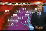
. >> i almost say steam because it's so humid. tonight a very humid night. you have to remember we heated up in to the upper 90's today, ground still warm. we are still feeling like 92 easton. heat plus humidity, feeling like 93hagerstown. heat warnings up a widespread. one of the largest heat warnings i have seen in maryland because this is not our garden variety heat advisory there. is through tomorrow evening. highs in to the upper 409's. 90s. 102, will be the high. don't forget to check out the latest weather where you live. you can could do it with any free i-phone app, the weather app or storm shield. they are all available. check them out. back to you. >> it was about this time last week that the rain first started coming down and then we got the lightning and the wind. when it was all over more than one million were without power throughout the state. the total number of customers in the dark is below the 15,000 mark but as christian joins us now, he ha here with a look at why it's taking to long to get that number down to zero. >> that's still a sig
. >> i almost say steam because it's so humid. tonight a very humid night. you have to remember we heated up in to the upper 90's today, ground still warm. we are still feeling like 92 easton. heat plus humidity, feeling like 93hagerstown. heat warnings up a widespread. one of the largest heat warnings i have seen in maryland because this is not our garden variety heat advisory there. is through tomorrow evening. highs in to the upper 409's. 90s. 102, will be the high. don't forget to...
153
153
Jul 29, 2012
07/12
by
WUSA
tv
eye 153
favorite 0
quote 0
not too much in the way of humidity. sot's feeling like 90 degrees, and we'll definitely keep our winds light and variable as we head into the overnight. mainly the northeast winds are keeping that humidity value down for us for right now. temperatures down to 82 out for reston. in all it's fairly comfortable region wide. we will continue to see some passing clouds from time to time as we get into the early morning hours on monday. that's when we'll see some of the partial clearing and then get our temperatures back up into the upper 80s by tomorrow afternoon. so a very comfortable night for tonight. you might want to open up that window, let that breeze come on through. and the showers will end by midnight. so host of us are already in the clear -- most of us are already in the clear. we'll head back into the 80s for monday and tuesday. only those upper 80s pushing 90 degrees, but much more comfortable with lower humidity. then as we get into the afternoon, evening hours each day next week, we will continue to see the oppo
not too much in the way of humidity. sot's feeling like 90 degrees, and we'll definitely keep our winds light and variable as we head into the overnight. mainly the northeast winds are keeping that humidity value down for us for right now. temperatures down to 82 out for reston. in all it's fairly comfortable region wide. we will continue to see some passing clouds from time to time as we get into the early morning hours on monday. that's when we'll see some of the partial clearing and then get...
213
213
Jul 16, 2012
07/12
by
WBAL
tv
eye 213
favorite 0
quote 0
it's very humid so not very enjoyable. the last heat wave was dry. you weren't drenched in sweat but this is more humid. today up to 100 in minneapolis. des moines in 97. through the three-day heat wave, we should see it through wichita, mid-90s around chicago, and d.c. by the end of the heat wave has a chance of hitting near 100 degrees. that's a look at your national forecast. now here's a look at the weather outside your window. today will be very warm. we'll see a few scattered storms, areas of florida typical this time of year. if you're lucky around charlotte you'll see a shower or storm, but no luck from our friends from kansas city to indianapolis. another heat wave. we barely got done with the last one. >> you're going to sound like a broken record. >> could be every certainly. just like last year. >> don't say that, please new big ben walks up the hill, pump prices fall and an exciting difference on the internet. your early morning business headlines are straight ahead. >>> cool, cartoon critters at the box office. >>> and jeremy lyn's net c
it's very humid so not very enjoyable. the last heat wave was dry. you weren't drenched in sweat but this is more humid. today up to 100 in minneapolis. des moines in 97. through the three-day heat wave, we should see it through wichita, mid-90s around chicago, and d.c. by the end of the heat wave has a chance of hitting near 100 degrees. that's a look at your national forecast. now here's a look at the weather outside your window. today will be very warm. we'll see a few scattered storms,...
272
272
Jul 18, 2012
07/12
by
WRC
tv
eye 272
favorite 0
quote 0
it is just so humid. much more humid than it was this time yesterday morning.e a steamier day, as well. as a result, we've got temperatures that even though they look comfortable in the low to mid 70s, it is really steamy. the air out here is like breathing maple syrup. 80 at reagan national. near 80 by the bay. 70s across the rest of virginia and maryland. and into west virginia, many locations are right near 70. all of these counties in orange are under a heat advisorying 11:00 this morning to 9:00 this evening. the peak of the heat will be around 3:00 to 5:00 p.m. that time, temperatures near 100. it will feel around 105 when you factor in the humidity. and then 6:00 to as late as maybe 8:00 of 9:00, 10:00, could get strong storms that might produce damaging winds, unfortunately. that might cause some power outages. i'll be back in ten minutes with another update. danella, how is our traffic? >> good morning, tom i'm still watching the situation on georgetown pike. your closure is right near walker mill road. alternate this morning is leesburg pike. this is
it is just so humid. much more humid than it was this time yesterday morning.e a steamier day, as well. as a result, we've got temperatures that even though they look comfortable in the low to mid 70s, it is really steamy. the air out here is like breathing maple syrup. 80 at reagan national. near 80 by the bay. 70s across the rest of virginia and maryland. and into west virginia, many locations are right near 70. all of these counties in orange are under a heat advisorying 11:00 this morning...
398
398
Jul 15, 2012
07/12
by
FOXNEWSW
quote
eye 398
favorite 0
quote 1
i was never so wet, so humid, so hot anytime in my life. >> most everyone said they are grateful for the lessons they learned. e >> theye taught me that if you work heyard you can earn things and accumulate things. >> it taught you the value of work and the dignity of work. there is something about getting it yourself. >> it taught you to keep showing up for work. >> it taught me to be puncture. punctual. >> it taught me i can do better than m minimum wage. i went out the next summer and bought my own lawn mower and charge people $8 to mow their lawns and do it in an hour and i got a much better -- i had a more lucrative business working for myself. >> i learned if i wanted to buy anything for myself, i needed money, and i b needed to make my own money. it was a lesson i learned very early on. i was notten titled to anything. so it was -- in all regards it was the beginning of a life as a capitalist. >> it was a hoot that early in the morning to make a little money. >> his job was working on a double decker bus in london. >> it taught me how do you deal with drunks? how do you deal w
i was never so wet, so humid, so hot anytime in my life. >> most everyone said they are grateful for the lessons they learned. e >> theye taught me that if you work heyard you can earn things and accumulate things. >> it taught you the value of work and the dignity of work. there is something about getting it yourself. >> it taught you to keep showing up for work. >> it taught me to be puncture. punctual. >> it taught me i can do better than m minimum wage. i...
580
580
Jul 15, 2012
07/12
by
FOXNEWSW
tv
eye 580
favorite 0
quote 0
i've never been so humid and so hot any time in my life. >> john: most everyone said they are grateful for the lessons they learned. >> if you work hard, you can earn things and accumulate things. >> much of the value of work and also the dignity of the work. there is something about getting it yourself. >> it taught me you had to keep showing up for work. >> it taught me to punctual. people don't get a newspaper they are angry. >> what it taught me i could do better than minimum wage. next summer i bought my own lawnmower i would charge $8 to mow their lawns and i much more lucrative business. >> i learned if i wanted to buy anything for myself i needed money and i needed to make my own money. it was a lesson i learned very early on. i was entitled to anything. in all regards it was the beginning of a life that as a capitalist. >> i learned it was kind of a hoot that early in the morning to make a little money. >> his first job was working double-decker buses? >> it taught me a lot. how to deal with drunks and deal with general public. it also taught you punk wallet. you may not be la
i've never been so humid and so hot any time in my life. >> john: most everyone said they are grateful for the lessons they learned. >> if you work hard, you can earn things and accumulate things. >> much of the value of work and also the dignity of the work. there is something about getting it yourself. >> it taught me you had to keep showing up for work. >> it taught me to punctual. people don't get a newspaper they are angry. >> what it taught me i could...
189
189
Jul 25, 2012
07/12
by
WUSA
tv
eye 189
favorite 0
quote 0
but less humid. so you have to get outside and enjoy it. will be in the upper 80s with west winds 5-10 miles per hour. here is your zone forecast. we start in western maryland, oakland 67. cumberland lower 80s. winchester, martinsburg and hagerstown near mid 80s. leesburg 85. culpeper you should get to right around 90 degrees. in downtown upper 80s. it will be seasonal. your next three days, 9 weather alert code clear for wednesday. thursday yellow. very hot. high 100 degrees. then on friday 94 with a chance for some stray storms. check out your next seven days, the weekend looks pretty good. lower 90s, upper 80s with a chance for showers and storms and a better chance for showers and storms will be on saturday afternoon. next week looking like we'll also top out in the upper 80s to lower 90s. so, again, tomorrow lower humidity. it's going to feel good. you will notice the air being a little fresher and then the heat is back on thursday. maybe even a heat advisory may have to be issued according to the national weather service for thursday.
but less humid. so you have to get outside and enjoy it. will be in the upper 80s with west winds 5-10 miles per hour. here is your zone forecast. we start in western maryland, oakland 67. cumberland lower 80s. winchester, martinsburg and hagerstown near mid 80s. leesburg 85. culpeper you should get to right around 90 degrees. in downtown upper 80s. it will be seasonal. your next three days, 9 weather alert code clear for wednesday. thursday yellow. very hot. high 100 degrees. then on friday 94...
171
171
Jul 3, 2012
07/12
by
WTTG
tv
eye 171
favorite 0
quote 0
that is the problem today is the humidity. not so much the heat right now. >> that's what they say, it is not the heat, it's the humidity. it's both. i agree with wisdom. we were talking about this. >> people are talking about the difference between the dry heat. if you are hot, it is uncomfortable either way. >> i thought it felt a little better yesterday. >> not me. >> you spent the day outside working in the yard. >> that was an issue. >> i'm not usually doing that kind of work. >> you don't do that manual labor. >> i try to stimulate the economy by getting somebody else to do it. >> i'm throwing the towel in on my yard this year. temperatures some some spots have cooled off into the upper 60s and low 70s so we're doing a little better this morning than we have the last couple of mondayings. nice and warm here at reagan national. baltimore, 69. that is a little better. leonardtown, good morning. 72 for you. now, some 60s off to the north and west. 6 # in martinsburg. 6 # in hagerstown. parts of the area doing a little bit better t
that is the problem today is the humidity. not so much the heat right now. >> that's what they say, it is not the heat, it's the humidity. it's both. i agree with wisdom. we were talking about this. >> people are talking about the difference between the dry heat. if you are hot, it is uncomfortable either way. >> i thought it felt a little better yesterday. >> not me. >> you spent the day outside working in the yard. >> that was an issue. >> i'm not...
314
314
Jul 25, 2012
07/12
by
WRC
tv
eye 314
favorite 0
quote 0
tomorrow morning it will be more on the humid side, so a warmer start than what we saw this morning,ot bad. temperatures 66 to 73 degrees. it will warm up very quickly, however. we'll see a high near -- 91 on saturday, 89 on sunday. then it gets unsettled i don't see much of a chance to get above 90, that could be a good day. a chance of showers and storms. >>> not too bad. >>> still to come on news4, first michael jackson's mother was reported missing. now she's lost custody of his children. the latest on a bizarre family feud that wound up in court today. >>> a serious case of road rage captured on tape. a driver pulls >>> more jackson family drama. just days after being reported missing, michael jackson's mother no longer has custody of his children. welcome back to "news4 at 4." i'm jim rosin field in for jim handly. >> and i'm pat lawson muse. a judge appointed tito jackson's son as a temporary guardian. >> the judge is concerned she left for arizona with no warning, and-hand spoken total children in days. all this is going on with the concert tour in the background. kerry berg
tomorrow morning it will be more on the humid side, so a warmer start than what we saw this morning,ot bad. temperatures 66 to 73 degrees. it will warm up very quickly, however. we'll see a high near -- 91 on saturday, 89 on sunday. then it gets unsettled i don't see much of a chance to get above 90, that could be a good day. a chance of showers and storms. >>> not too bad. >>> still to come on news4, first michael jackson's mother was reported missing. now she's lost custody...
113
113
Jul 26, 2012
07/12
by
WUSA
tv
eye 113
favorite 0
quote 0
and so we will see the humidity back in full swing tomorrow. so the heat and humidity are returning, and we're looking at some record breaking heat possible by tomorrow afternoon. strong afternoon, evening thunderstorms are possible. they'll be few and far between, but then we'll be looking to be hot again for friday. so here is a look at the risk for severe weather according to the storm prediction center in oklahoma. so you can see the moderate risk up far north into pennsylvania and new york. but we fall under a slight risk for some severe storms generally in the district and points north and the main threats are going to be damaging winds. farther north they're talking about rain. here is a look at your future cast. so friday morning we'll see plenty of sunshine. actually on thursday morning we'll see plenty of morning. a stray storm possible thursday. friday we're looking at a better chance for some scattered showers and thunderstorms. also the weekend can be unsettled at times as well. but temperature wise, we're not talking triple digits
and so we will see the humidity back in full swing tomorrow. so the heat and humidity are returning, and we're looking at some record breaking heat possible by tomorrow afternoon. strong afternoon, evening thunderstorms are possible. they'll be few and far between, but then we'll be looking to be hot again for friday. so here is a look at the risk for severe weather according to the storm prediction center in oklahoma. so you can see the moderate risk up far north into pennsylvania and new...
167
167
Jul 16, 2012
07/12
by
WUSA
tv
eye 167
favorite 0
quote 0
we will top out afternoon highs in the mid 90s today so it is going to be hot and humid. currently mostly cloudy and 77 degrees. back to you guys. >> good morning monika. >> reporter: good morning annie. northbound i-95 north of dale city the accident clean up continues and it is blocking one lane. watch out through that area. i'll have more coming up in my next report in a few minutes. back to you guys. >>> here's what's making news now this morning. searchers found one body this weekend but a father and his two daughters are still missing after a landslide in british columbia, canada. >>> the international committee of the red cross is now calling the fighting in syria a civil war. social media websites posted video sunday claiming to show shelling in the capital city of damascus. >>> secretary of state hillary clinton is on her first visit to israel this morning in nearly two years. she is there to discuss the regional issues. while she was in egypt this weekend clinton's motorcade was pelted with water bottles and tomatoes. >>> are your kids dependent on their electro
we will top out afternoon highs in the mid 90s today so it is going to be hot and humid. currently mostly cloudy and 77 degrees. back to you guys. >> good morning monika. >> reporter: good morning annie. northbound i-95 north of dale city the accident clean up continues and it is blocking one lane. watch out through that area. i'll have more coming up in my next report in a few minutes. back to you guys. >>> here's what's making news now this morning. searchers found one...
186
186
Jul 14, 2012
07/12
by
FOXNEWS
tv
eye 186
favorite 0
quote 0
i've never been so humid and so hot any time in my life. >> john: most everyone said they are gratefulor the lessons they learned. >> if you work hard, you can earn things and accumulate things. >> much of the value of work and also the dignity of the work. there is something about getting it yourself. >> it taught me you had to keep showing up for work. >> it taught me to punctual. people don't get a newspaper they are angry. >> what it taught me i could do better than minimum wage. next summer i bought my own lawnmower i would charge $8 to mow their lawns and i much more lucrative business. >> i learned if i wanted to buy anything for myself i needed money and i needed to make my own money. it was a lesson i learned very early on. i was entitled to anything. in all regards it was the beginning of a life that as a capitalist. >> i learned it was kind of a hoot that early in the morning to make a little money. >> his first job was working double-decker buses? >> it taught me a lot. how to deal with drunks and deal with general public. it also taught you punk wallet. you may not be late
i've never been so humid and so hot any time in my life. >> john: most everyone said they are gratefulor the lessons they learned. >> if you work hard, you can earn things and accumulate things. >> much of the value of work and also the dignity of the work. there is something about getting it yourself. >> it taught me you had to keep showing up for work. >> it taught me to punctual. people don't get a newspaper they are angry. >> what it taught me i could do...
165
165
Jul 16, 2012
07/12
by
WTTG
tv
eye 165
favorite 0
quote 0
so plenty of warm temperatures. plenty of humidity as well. our dew point temperatures, that measures the amount of water in the atmosphere, in the upper 60s to about 07. so that is in the up comfortable range. you will notice that because we had a lot of rain across parts of the area during the late afternoon, early evening yesterday. our short wave pushing offer the coast there. you can see it well to the east now of new york. we are looking at quieter conditions. we have this one little complex up into pennsylvania. but i think the friend trend will be lots of just hazy sunshine today with a few clouds moving through from time to time and perhaps a late day shower although much of your day and most of the region should be dry this afternoon. 94 the daytime high. mostly sunny and hot. could be a few afternoon showers across the region. might be a thunderstorm too if you're south of the city into southern maryland, lower eastern shore. 76 tonight, warm and muggy overnight. your five-day forecast, the heat continues tomorrow. it becomes even wa
so plenty of warm temperatures. plenty of humidity as well. our dew point temperatures, that measures the amount of water in the atmosphere, in the upper 60s to about 07. so that is in the up comfortable range. you will notice that because we had a lot of rain across parts of the area during the late afternoon, early evening yesterday. our short wave pushing offer the coast there. you can see it well to the east now of new york. we are looking at quieter conditions. we have this one little...
130
130
Jul 29, 2012
07/12
by
CSPAN2
tv
eye 130
favorite 0
quote 0
the weather is holding out for you, it's not so hot today and not so humid, which is great. how many of you have heard -- what do you think of when you think of fast and furious? what's the first thing that pops into your head? >> [inaudible] >> scandal, for you? anyone think of the movie? [laughter] the series of movies. >> obama's trying to get people to think that -- [inaudible] >> right. exactly. he won't admit that his own justice department sent them to cartels to kill people. well, the embarrassing part about the name fast and furious is that the obama justice department actually named this lethal program after the hollywood movie, and i have the official government slide show, atf slide show cover to prove it. they actually took a screen shot of the hollywood movie cover and put it into their official documents as an official name. so the unfortunate thing is that this operation fast and furious isn't about racing and stealing fancy cars, it's about, um, something that the justice department claimed to be a program where they were going to allow straw purchasers who
the weather is holding out for you, it's not so hot today and not so humid, which is great. how many of you have heard -- what do you think of when you think of fast and furious? what's the first thing that pops into your head? >> [inaudible] >> scandal, for you? anyone think of the movie? [laughter] the series of movies. >> obama's trying to get people to think that -- [inaudible] >> right. exactly. he won't admit that his own justice department sent them to cartels to...
381
381
Jul 15, 2012
07/12
by
WRC
tv
eye 381
favorite 0
quote 0
so today, humid with some showers around this morning.all the humidity, a little trough of low pressure. that's what the black line stands for. that may focus showers and thunderstorms later on this afternoon. things quiet down overnight tonight. mild and muggy again by your monday morning. then tomorrow afternoon, right back in the heat we go. temperatures tomorrow with just an isolated scattering of thunderstorms around. back up into the low and mid 90s tomorrow. upper 90's coming after that. so today, plenty of clouds around. showers likely this morning. a chance for some thunderstorms this afternoon. highs, upper 80s. tomorrow, warmer, fewer storms, into the 90s for sure tomorrow. if you're headed to the beaches, not the best beach day. but the coastline will be improving. here's our seven-day forecast. rain chances are diminishing as we get into monday and tuesday. back again by wednesday. but by wednesday, that could be an ugly, hot day. 98 degrees on wednesday. heat index well over 100. be ready. >> all right. we will. thanks. >>>
so today, humid with some showers around this morning.all the humidity, a little trough of low pressure. that's what the black line stands for. that may focus showers and thunderstorms later on this afternoon. things quiet down overnight tonight. mild and muggy again by your monday morning. then tomorrow afternoon, right back in the heat we go. temperatures tomorrow with just an isolated scattering of thunderstorms around. back up into the low and mid 90s tomorrow. upper 90's coming after that....
161
161
Jul 2, 2012
07/12
by
WUSA
tv
eye 161
favorite 0
quote 0
you know, that means simply that the humidity won't add anything to the air in terms of temperatures. what we feel is 92. you feel what you get, soeak. humidity 32%. winds out of the north at 6. pressure is falling. satellite picture, radar combined, a couple thunderstorms south down towards charlottesville and a few clouds toward pittsburgh. right now we don't see anything developing. i'll keep the chance of an isolated thunderstorm in the forecast for another couple of hours. 92 downtown. 92 in rockville. we haven't talked about 80s. 89 in great falls. 86 in fairfax. and 89 in springfield. that's really pretty nice. because the air mass is dry, temperatures will fall at lower levels tonight. especially in the suburbs. 90s with us all week. warm tonight, maybe a thunderstorm. tomorrow, another copy and paste day. and big storms are possible on the fourth and probably hotter on wednesday. partly cloudy, warm. maybe a thunderstorm. almost comfortable. low 65 to 75. so 65 in the suburbs is pretty decent. now tomorrow morning, partly cloudy, warm. 70 to 90 by lunchtime. air quality in the unhealthy range. that's not unusual. by afte
you know, that means simply that the humidity won't add anything to the air in terms of temperatures. what we feel is 92. you feel what you get, soeak. humidity 32%. winds out of the north at 6. pressure is falling. satellite picture, radar combined, a couple thunderstorms south down towards charlottesville and a few clouds toward pittsburgh. right now we don't see anything developing. i'll keep the chance of an isolated thunderstorm in the forecast for another couple of hours. 92 downtown. 92...
184
184
Jul 2, 2012
07/12
by
WUSA
tv
eye 184
favorite 0
quote 0
humidity. it still feels 91. 91 in manassas and leesburg. so, the good news is, we are well below heat advisory. it's still hot, but the good news is, the dangerous heat is subsided for a while. heat will continue. 90s are with us all week. warm tonight, maybe a storm. but again, doppler is quiet right now. tuesday, another copy and paste day. and big storms are possible for the fourth. we are used to that. for tonight, partly cloudy and warm. thunderstorm possible. almost comfortable. lows in the mid 60s in the suburbs and mid 70s downtown. that's kind of nice that we don't have power. tomorrow morning, partly cloudy, warm. 70 to 90. as it warms up quickly. and by afternoon, partly cloudy and hot, got to keep the chance of a thunderstorm in. high temperatures near 95 and winds southwest at 10. almost as hot tomorrow as it was today. so the day planner then, 65 to 75 to start. 85 to 90 by noon and 93 to 97 by evening. we're looking at an afternoon thunderstorm. that heat continues. next three days, stay yell low because of the heat and because
humidity. it still feels 91. 91 in manassas and leesburg. so, the good news is, we are well below heat advisory. it's still hot, but the good news is, the dangerous heat is subsided for a while. heat will continue. 90s are with us all week. warm tonight, maybe a storm. but again, doppler is quiet right now. tuesday, another copy and paste day. and big storms are possible for the fourth. we are used to that. for tonight, partly cloudy and warm. thunderstorm possible. almost comfortable. lows in...
227
227
Jul 13, 2012
07/12
by
WUSA
tv
eye 227
favorite 0
quote 0
so humidity actually doesn't feel too bad. just yet. that will change though over the weekend. y morning commute for most of us unless you're far west of town. still seasonable so looks pretty good for a july day. isolated thunderstorms possible west of town mainly. and then we're looking to get hot over the weekend. 90s are back. and even triple digit heat. here's a look at your 9 futurecast. so today, we're looking at just cloudy conditions and it will be also cloudy through your saturday not a whole lot of sunshine. may get some breaks again most of the showers and activity stay out to the west for today. now tomorrow a different story. a better chance for some scattered showers and thunderstorms mainly maybe late morning and in the afternoon and early evening hours. same deal for sunday. so we have a stationary boundary front coming through which will also then change into a warm front bringing in some warmer conditions for the weekend. but today, temperature for d.c. 87 degrees is your high. 87 also for manassas. mid 80s for frederick and gaithersburg. here's a look at your
so humidity actually doesn't feel too bad. just yet. that will change though over the weekend. y morning commute for most of us unless you're far west of town. still seasonable so looks pretty good for a july day. isolated thunderstorms possible west of town mainly. and then we're looking to get hot over the weekend. 90s are back. and even triple digit heat. here's a look at your 9 futurecast. so today, we're looking at just cloudy conditions and it will be also cloudy through your saturday not...
122
122
Jul 18, 2012
07/12
by
WTTG
tv
eye 122
favorite 0
quote 0
our humidity levels have been kind of creeping up and you will notice that humidity in addition to the temperatures today. so we've got a heat advisory which goes into effect at 11:00 this morning. actual air temperature about 100. mix in the humidity, it will feel like 105 to 109 later today. if you will be out, lots and lots of water. if you can, get in the shade. take it easy outdoors later this afternoon as that heat will be dangerous for a time. there is our relief. apts cold front now pushing into portions of northwest pennsylvania and new york. doesn't look terribly impressive at this hour but as the day progresses here, we'll see some thunderstorms develop along it and it will start to push into our area later this afternoon. so look out for the potential for some scattered strong storms here any time i think after about 2:00, 3:00 today through the evening rush hour into the nighttime hours. this front will take a very, very long time to get south of us. but at least we will transition into a cooler weather pattern here. starting tomorrow, highs will only be about 90 and back into the 80s with less
our humidity levels have been kind of creeping up and you will notice that humidity in addition to the temperatures today. so we've got a heat advisory which goes into effect at 11:00 this morning. actual air temperature about 100. mix in the humidity, it will feel like 105 to 109 later today. if you will be out, lots and lots of water. if you can, get in the shade. take it easy outdoors later this afternoon as that heat will be dangerous for a time. there is our relief. apts cold front now...
200
200
Jul 20, 2012
07/12
by
WBAL
tv
eye 200
favorite 0
quote 0
so things are moving along, so we're dry here, still cloudy, very humid. a patch or two of fog. so scattered showers, maybe a rumble of thunder out to the west. the situation today, the setup very similar to yesterday, nothing has changed much. the only difference is we won't be as hot today as we were yesterday. temperatures wednesday, we peaked out, we were in the low to mid 100's. yesterday we were only in the 90's. today we expect to be in the 80's. and then we'll start in the 80's for a few days, slowly climbing next week, but at least a lot closer to what is normal for this time of year. and i mentioned the situation today, we still have the humidity, the front that generated the rain last night is still here. temperatures are in the 70's this morning and very humid, so it feels about the same as it did yesterday morning. 60's out to the west of us in the mountains, a little higher he will vace. here's the radar-satellite combination. and here's the storm activity that went through last night. it moves out over the ocean right now, a few lingering showers in the northern po
so things are moving along, so we're dry here, still cloudy, very humid. a patch or two of fog. so scattered showers, maybe a rumble of thunder out to the west. the situation today, the setup very similar to yesterday, nothing has changed much. the only difference is we won't be as hot today as we were yesterday. temperatures wednesday, we peaked out, we were in the low to mid 100's. yesterday we were only in the 90's. today we expect to be in the 80's. and then we'll start in the 80's for a...
183
183
Jul 13, 2012
07/12
by
WUSA
tv
eye 183
favorite 0
quote 0
check out the next seven days so we're going to be in the 90s by the weekend. the humidity also will be on the rise. so if your sunday and monday then boy do we get hot once against. tuesday upper 90s and not the best weather for baseball but we can deal with it. and by wednesday temperatures around 100 degrees. here's a look at your timesaver traffic with monika. good morning. >>> you know and i was at the castles' home opener last night and a beautiful so nice night for that. if you're planning to head outside right now, nice morning to commute. at least because there's no major incidents to report i'm happy to say. 66 the dulles toll road both look great. no problems as you head inbound from sterling or even from manassas all the way to the beltway and here through the corner there may have been some leftover construction but that's -- the only reason why you're seeing the yellow and orange here and that should clear up shortly as well. on the inbound side of i-66 nice and light through centreville. in fairfax station there's a paving operation it's northbound on route 7
check out the next seven days so we're going to be in the 90s by the weekend. the humidity also will be on the rise. so if your sunday and monday then boy do we get hot once against. tuesday upper 90s and not the best weather for baseball but we can deal with it. and by wednesday temperatures around 100 degrees. here's a look at your timesaver traffic with monika. good morning. >>> you know and i was at the castles' home opener last night and a beautiful so nice night for that. if...
351
351
Jul 7, 2012
07/12
by
WBAL
tv
eye 351
favorite 0
quote 0
today, the humidity is going back up again and the temperatures are going up. >> so let's just start out with saying where we're starting this morning, all right? at the airport right now, it's 79 degrees. i mean, that's a warm start to the day. 74% the humidity. but the dew point temperature we don't express it there is 69. yesterday, dew point temperatures were down around 60 so the higher it gets, the more humid it gets. the 74% is a pretty humid atmosphere at that temperature. the southwest wind at 3 miles an hour and the inner harbor, they're not clocking us at a temperature right now. there was one a minute ago. all of a sudden, it disappeared. the inner harbor is in the low 80's this morning the last time i looked at it which was about 10 minutes ago. we'll talk more about where the heat is going today. i don't think you're going to like it. forecast ahead. >> it could be record breaking so how that could factor into your plans this weekend is our story this morning. >> 11 news reporter sheldon dutes has more on how it's affecting major events this weekend. >> the heat has gott
today, the humidity is going back up again and the temperatures are going up. >> so let's just start out with saying where we're starting this morning, all right? at the airport right now, it's 79 degrees. i mean, that's a warm start to the day. 74% the humidity. but the dew point temperature we don't express it there is 69. yesterday, dew point temperatures were down around 60 so the higher it gets, the more humid it gets. the 74% is a pretty humid atmosphere at that temperature. the...
216
216
Jul 27, 2012
07/12
by
KGO
tv
eye 216
favorite 0
quote 0
breeze up through the san pablo bay into the delta that's why so much cloud cover and why the area is so humid with that mist and drizzle. temperatures in the 50s. lunch hour clouds back at the coast temperatures upper 50s, mid 60s around the bay low self teeth inland. by 4:00, clouds stubborn at the coast where they will be at 4:00, 60 for you, low 70s around the bay upper 70s inland. 7:00 hour, friday heading out, upper 60s inland, mid 60s around the bay upper 50s at the coast, everybody might need a light jacket. tree and recognize we'd low, grass and mold -- tree and ragweed low, grass and mold high. >>> good morning. san rafael live shot southbound taillights past the civic center on 101, roadwork in the northbound direction through cortamadera, repaving should be picked up by 5:30. elsewhere light traffic at the bay bridge toll no metering lights, no problems upper deck into san francisco incline section looking good. update on this accident at hilltop in richmond eastbound 80 has been cleared out of lanes and you will find traffic getting by that accident on the shoulder. elsewhere arou
breeze up through the san pablo bay into the delta that's why so much cloud cover and why the area is so humid with that mist and drizzle. temperatures in the 50s. lunch hour clouds back at the coast temperatures upper 50s, mid 60s around the bay low self teeth inland. by 4:00, clouds stubborn at the coast where they will be at 4:00, 60 for you, low 70s around the bay upper 70s inland. 7:00 hour, friday heading out, upper 60s inland, mid 60s around the bay upper 50s at the coast, everybody...
183
183
Jul 25, 2012
07/12
by
WTTG
tv
eye 183
favorite 0
quote 0
wasn't terribly hot but it is so humid that -- >> it was a bit uncomfortable yesterday. >> let's gets here. take a look at these temperatures. falling back into the 60s. 63degrees in gaithersburg. 66? manassas. leonardtown, good morning, you are 73 degrees. temperatures getting very, very comfortable overnight as we haven't fallen back in the 60s a whole lot this month. 64 out in winchester. 66 in culpeper. temperature have fallen into the 60s and low 70s. our dew point temperatures, that measures how much water we have in the atmosphere. yesterday, they were running in the low 70s. today, upper 50s and low 60s. so noticeably drier air moving in as well. should be a beautiful-looking day. our front from yesterday pushed down into the carolinas. it is out of here. and we are looking at bright sunshine across the region and absolutely comfortable afternoon here with temperatures expected to be in the mid-80s. kind of unusual here for the end of july but we have a very active weather pat were here the next couple of days. don't get used to any one weather pattern. today, we'll be cool w
wasn't terribly hot but it is so humid that -- >> it was a bit uncomfortable yesterday. >> let's gets here. take a look at these temperatures. falling back into the 60s. 63degrees in gaithersburg. 66? manassas. leonardtown, good morning, you are 73 degrees. temperatures getting very, very comfortable overnight as we haven't fallen back in the 60s a whole lot this month. 64 out in winchester. 66 in culpeper. temperature have fallen into the 60s and low 70s. our dew point...
167
167
Jul 10, 2012
07/12
by
WMAR
tv
eye 167
favorite 0
quote 0
so that is the trend right now. >> it feels really thick out there today. >> the humidity, believe it or not, is not as high as lastperatures have come down, so it's humid. july in maryland, kelly, come on. >> all right. >> we've gotta take it. >>> now, president obama and mitt romney back on the campaign trail. they're hitting some key bottle ground states. troy is live in washington. >> reporter: today president obama is in iowa, a state he won four years ago. meanwhile, mitt romney is back from vacation and he's hitting the campaign trail in colorado. both of these states so far are offering up extremely course races. what you're going to see in iowa, it is a dead heat between obama and romney. but 10% of the voters there are actually unsure about who they might pick. in colorado, it's a similar story, a statistical tie between president obama and romney. it could be the uncertainty that's causing the candidates to get more personal in these attacks. >> my opponent's plan is to let the housing market hit bottom. governor romney said we should let them go bankrupt. >> i just don't think this president understands
so that is the trend right now. >> it feels really thick out there today. >> the humidity, believe it or not, is not as high as lastperatures have come down, so it's humid. july in maryland, kelly, come on. >> all right. >> we've gotta take it. >>> now, president obama and mitt romney back on the campaign trail. they're hitting some key bottle ground states. troy is live in washington. >> reporter: today president obama is in iowa, a state he won four...
180
180
Jul 17, 2012
07/12
by
WRC
tv
eye 180
favorite 0
quote 0
humid. how is our traffic? >>> so far, not so bad. not seeing any major incidents. still seeing some road work affecting your commute though. virginia, 234, road work there. it's just in the shoulder lane. travel lanes are open. let's make our away northbound and check out travel speeds from the occuquan. travel lanes are open to the beltway. 62 miles per hour. continuing on to 395, travel lanes are open. here's a live look right now as you make your way past duke street. north and southbound between the beltway and 14th street bridge in this area. nice and clear. northbound travel speed you're at about 61 miles per hour. 12 minutes. making the commute along i-66, i've got you covered in ten minutes. >>> traffic will soon be moving more easily around fort belvoir in west virginia. 3 1/2 mile stretch between telegraph road and mt. vernon memorial highway will go from four to six lanes. traffic has increased greatly since base realignment moved thousands of employees to that site. >>> a major milestone today on construction of metro's new silver line. crews will insta
humid. how is our traffic? >>> so far, not so bad. not seeing any major incidents. still seeing some road work affecting your commute though. virginia, 234, road work there. it's just in the shoulder lane. travel lanes are open. let's make our away northbound and check out travel speeds from the occuquan. travel lanes are open to the beltway. 62 miles per hour. continuing on to 395, travel lanes are open. here's a live look right now as you make your way past duke street. north and...
298
298
Jul 16, 2012
07/12
by
WRC
tv
eye 298
favorite 0
quote 0
so humid, look what i found under my lapel. >> oh, no. >> fungi. >> a mushroom. >> growing on the ground right here. we've got a lot of humidity. the ground is all wet from yesterday's rain. you can see the gorgeous sun behind me. now streaming across the lawn, golden sunlight. this morning under a blue sky. we've cleared out. there's the view from space. we have just a few clouds coming through from the north and west from a dissipating thunder shower up in pennsylvania. yes, right now it's comfortable. and it has turned a little less humid than yesterday. we're in the low to mid 70s throughout the metro area. west and north of us, upper 60s near 70 in frederick county, howard and washington county and western maryland. much of west virginia in the 60s right now. shenandoah valley, 60s to 70. southern maryland, much of northern virginia including fairfax and arlington now in the low 70s. mid 70s. we ought to be 20 degrees hotter though by mid afternoon up into the mid 90s. just a slight chance of an isolated thunder shower. and it will be rather humid throughout the day. i'll be back in
so humid, look what i found under my lapel. >> oh, no. >> fungi. >> a mushroom. >> growing on the ground right here. we've got a lot of humidity. the ground is all wet from yesterday's rain. you can see the gorgeous sun behind me. now streaming across the lawn, golden sunlight. this morning under a blue sky. we've cleared out. there's the view from space. we have just a few clouds coming through from the north and west from a dissipating thunder shower up in...
174
174
Jul 30, 2012
07/12
by
WMAR
tv
eye 174
favorite 0
quote 0
humidity moderate. dew point numbers in the upper 60s, low 70s. so it is humid. mid-80s a little misleading. even though we have a bit of a breeze with that bries off the bay and -- breeze off the bay and the atlantic, that dew point around 72 in cambridge. so sticky conditions absolutely. heat plus humidity, what it feels like low to mid-90s. a scattering of showers from maryland up into pennsylvania. but the main weather maker on the map is off the carolinas. we'll be watching our one weather wild card, this coastal system off cape hatteras just beginning to get its act together. we think the track will stay offshore. if it were to push further in that would mean more rain and more unsettled conditions for maryland. it all depends on the track of the low. by the way, this time of the year you can see some border line tropical development. the temperatures off of the outer banks are very warm and the gulf stream in particular. we'll see if it develops and see how it moves, but it could play a real wild card late this week and into the weekend. you'll want to keep posted on the movement of t
humidity moderate. dew point numbers in the upper 60s, low 70s. so it is humid. mid-80s a little misleading. even though we have a bit of a breeze with that bries off the bay and -- breeze off the bay and the atlantic, that dew point around 72 in cambridge. so sticky conditions absolutely. heat plus humidity, what it feels like low to mid-90s. a scattering of showers from maryland up into pennsylvania. but the main weather maker on the map is off the carolinas. we'll be watching our one weather...
273
273
Jul 16, 2012
07/12
by
WRC
tv
eye 273
favorite 0
quote 0
so humidity at 4%. we often talk about the dew point.t's the real measure of moisture in the atmosphere. how hiumid is it? >> 69 is at the very top of huemy. we'ret 570. that's what we consider very humid. this is the really uncomfortable range and a couple time this summer we had dew points of 75 or higher and that even when you need to not go outside at all. on storm 4 radar there's the thundershower right there that you saw on our tower camera view literally coming straight down the potomac river into the upper parts of northwest washington. so you folks here, bethesda, chevy chase, mclaeaclean, great fauk falls, it bears watching. it will get you wet in the next couple of hours. there's 301. down toward bud's creek. this storm also drifting down to the southeast at about 20 to 30 miles per hour. the storms are moving along at a little better pace than they did over the weekend. be on the lookout for rain there. st. mary's county, this is coming toward you even during the far southernmost tip there. getting in on a little bit of rain
so humidity at 4%. we often talk about the dew point.t's the real measure of moisture in the atmosphere. how hiumid is it? >> 69 is at the very top of huemy. we'ret 570. that's what we consider very humid. this is the really uncomfortable range and a couple time this summer we had dew points of 75 or higher and that even when you need to not go outside at all. on storm 4 radar there's the thundershower right there that you saw on our tower camera view literally coming straight down the...
389
389
tv
eye 389
favorite 0
quote 1
so humidity levels will be higher. and it will make it feel even hotter out there.t out there. this is what you want to see. they may need an extra hand in this weather. >> friday, severe storm of course, brought down hundreds of trees across the state, leaving many marylanders, with the burden of moving them. today, missed utility. the free call before you dig service, is recommending that you call them at 811, at least two full business days before you start to dig. this helps to prevent underground utility lines from being damaged. >>> for the latest conditions and updates any time, log onto wjz.com. >>> being a woman and having a cat can increase your risk of suicide. mary is in the newsroom with more on what a new study reveals. mary? >> reporter: well, vic, kitty litter boxes could be making women suicidal. that's according to a new report in the archives of general psychiatry. it says a parasite found in cat feces could be the problem. they conducted the study of 45,000 women in denmark, over a three-year period. women infected with the para sight had a 1 1/2
so humidity levels will be higher. and it will make it feel even hotter out there.t out there. this is what you want to see. they may need an extra hand in this weather. >> friday, severe storm of course, brought down hundreds of trees across the state, leaving many marylanders, with the burden of moving them. today, missed utility. the free call before you dig service, is recommending that you call them at 811, at least two full business days before you start to dig. this helps to...
135
135
Jul 3, 2012
07/12
by
WJLA
tv
eye 135
favorite 0
quote 0
so the humidity is slowly rising from the west and southwest.hat is giving us a little bit more of a heat index. it feels a little hotter than yesterday. i am focusing on the energy in the northwest. the energy causing that will slide to the east and southeast. i think we have more energy down here over parts of ohio and indiana that will drop towards washington later tonight and into tomorrow. that energy will probe the stuhr upper atmosphere enough with the instability overhead that we will have a few thunderstorms tonight. and during the daylight hours to our, you cannot rule out a thunderstorm, from sunrise to about sunset. here's the breakdown. a few thunderstorms and especially after sunset. temperatures tonight probably back down into the 70's for most of us. the fourth of july forecast of independence day, a mixture of sun and clouds -- typical fourth of july forecast for washington, really. we see this all the time. some, brief thunderstorm, son, brief thunderstorm, and then -- sun, brief thunderstorm, sun brief thunderstorm, and then f
so the humidity is slowly rising from the west and southwest.hat is giving us a little bit more of a heat index. it feels a little hotter than yesterday. i am focusing on the energy in the northwest. the energy causing that will slide to the east and southeast. i think we have more energy down here over parts of ohio and indiana that will drop towards washington later tonight and into tomorrow. that energy will probe the stuhr upper atmosphere enough with the instability overhead that we will...
136
136
Jul 5, 2012
07/12
by
WMAR
tv
eye 136
favorite 0
quote 0
you have 100% relative humidity. so that is some absolutely oppressive humidity and the air temp 101. with any humidity, that's outrageous heat. just enough to stir the air. we'll take it. it will not make a difference. the overall pattern is a hot one with scattered pop-up storm convex over the east -- convection over the east. it's pushing it to the dpfl course, southern alabama. we will get a taste of that on saturday, we think. so our heat bubble, the most intense part where they're not low 100's, i don't think it edges into tomorrow. tomorrow will be close to 100. more intense heat, ratchets up the heat saturday before we get a break. overnight 77. tom your two-degree darn -- guarantee just as hot. tomorrow night 80 or so. i don't think we'll get much below 80. we you have that warm of a start first thing inorning, that's how you can get to 102. the old record is 105. 80s next week. there is relief in sight but it take as knew days to get there. >> all right. there's one good thing about this extended code red heat
you have 100% relative humidity. so that is some absolutely oppressive humidity and the air temp 101. with any humidity, that's outrageous heat. just enough to stir the air. we'll take it. it will not make a difference. the overall pattern is a hot one with scattered pop-up storm convex over the east -- convection over the east. it's pushing it to the dpfl course, southern alabama. we will get a taste of that on saturday, we think. so our heat bubble, the most intense part where they're not low...
343
343
tv
eye 343
favorite 0
quote 0
that's why it's so humid. so maybe around the country today, temperatures aren't quite as hot for everybody as where they have been. but it actually will be more uncomfortable because those dewpoints, the measure of the moisture, is higher today. all right. so there's all that juice, all that fire in the atmosphere. 9:00 temperatures in boston, again, scattered showers and storms. 78. 86 in new york city. washington, this number says 83. but i think it's erroneous. this computer model is under the assumption that it will be raining or thunderstorms at that point, but it will much hotter and feel more humid than that. atlanta to new orleans, mostly dry skies but the afternoon is when we have the threat for showers and storms. and minneapolis, can you imagine, carol, minneapolis way hotter than -- this is the 9:00 temperature. >> wow. >> 102 potentially feeling like 110 there. way hotter than miami or key west, for that matter. >> at least we're all in it together. we're all sweating together. >> but more than ne
that's why it's so humid. so maybe around the country today, temperatures aren't quite as hot for everybody as where they have been. but it actually will be more uncomfortable because those dewpoints, the measure of the moisture, is higher today. all right. so there's all that juice, all that fire in the atmosphere. 9:00 temperatures in boston, again, scattered showers and storms. 78. 86 in new york city. washington, this number says 83. but i think it's erroneous. this computer model is under...
 Live Music Archive
 Librivox Free Audio
 Metropolitan Museum
 Cleveland Museum of Art
 Internet Arcade
 Console Living Room
 Open Library
 American Libraries
 TV News
 Understanding 9/11