149
149
Jun 5, 2012
06/12
by
WUSA
tv
eye 149
favorite 0
quote 0
spotty showers. best chance of that will be west of town out toward the blue ridge, higher elevations out west. this morning you can see the showers that have been coming through, especially the coastal areas here in calvert, anne arundel county, down across parts of the northern neck even a few showers. north beach right down route 4 here toward st. leonard and solomons into eastern areas of st. yary's county and coming down 95, a couple of sprinkles toward fauquier county to prince william, out of woodbridge. this will all be pulling away from us in the next hour or two. we're not bad. 55 now in gaithersburg and leesburg. 58 for haymarket. also in college park and fort belvoir. 57 in baden and crofton. outside on our michael & son weather camera, good visibility. you see some of the clouds now about a half-hour before the sunrise. 59 and cloudy at national with a northeast wind at 8. that is going to keep us on the cool side today. big storms still spinning out across areas of southeastern canada,
spotty showers. best chance of that will be west of town out toward the blue ridge, higher elevations out west. this morning you can see the showers that have been coming through, especially the coastal areas here in calvert, anne arundel county, down across parts of the northern neck even a few showers. north beach right down route 4 here toward st. leonard and solomons into eastern areas of st. yary's county and coming down 95, a couple of sprinkles toward fauquier county to prince william,...
76
76
Jun 6, 2012
06/12
by
WUSA
tv
eye 76
favorite 0
quote 0
temperatures by noon around 70 and a spotty shower. so shouldn't be much of a problem today except if you're going down toward charlottesville or roanoke. they're having more showers down there. we're currently 59. the reason the showers are farther south, that's where the energy is. you can sort of see that little twist coming out of west virginia right here coming in towards southwestern virginia. that is what's helping to give a little bit more lift and produce the showers, especially down in the carolinas. it's pouring in western north carolina. a lone shower southwest of easton by a few miles tort st. michaels. temperatures, some in the upper 40s. we're in the upper 50s going to the low 70s. wednesday morning traffic is looking good. >>> pretty decent although we've got a bit of slow traffic in some spots where we had late clearing construction, namely on 95. i'll get to that in just a minute. out of manassas on 66, you'll find the usual slow stuff leaving route 234 and in are inville in fairfax, things still looking pretty good.
temperatures by noon around 70 and a spotty shower. so shouldn't be much of a problem today except if you're going down toward charlottesville or roanoke. they're having more showers down there. we're currently 59. the reason the showers are farther south, that's where the energy is. you can sort of see that little twist coming out of west virginia right here coming in towards southwestern virginia. that is what's helping to give a little bit more lift and produce the showers, especially down...
111
111
Jun 18, 2012
06/12
by
WJLA
tv
eye 111
favorite 0
quote 0
spotty showers through the day. mostly cloudy with a few more peeks of sun later on this afternoon. 78 and comfortable today. we crank up the heat by the middle of the week. let's go back to cynne. >> there are two things i've learned. don't doubt adam and always fine reason to showboats in the water. >> that's right. the transit agency adding more trains to the green, yellow, blue and the orange line during the morning and evening rush hours. the hope is that it will relieve congestion. let's go to brianne carter with more. >> good morning to you cynne and steve. it's all part of this rush plus that kicks off in just about a half hour from 6:30 to 9:00 and 3:30 to 6:00 and some say it may be confusing and hard to understand. metro is hoping it will help with a little congestion relief. for tens of thousands of metro rail riders, their regular commute could be a bit different this morning. >> i think they're considering some things which could be really helpful for commuters in the system. >> the transit agency unve
spotty showers through the day. mostly cloudy with a few more peeks of sun later on this afternoon. 78 and comfortable today. we crank up the heat by the middle of the week. let's go back to cynne. >> there are two things i've learned. don't doubt adam and always fine reason to showboats in the water. >> that's right. the transit agency adding more trains to the green, yellow, blue and the orange line during the morning and evening rush hours. the hope is that it will relieve...
212
212
Jun 3, 2012
06/12
by
WTTG
tv
eye 212
favorite 0
quote 0
when i say spotty i mean spotty this looks like it will come on through, some places right now here in harrisburg there is a severe thunderstorm warning this is all moving down if you notice looks like hagerstown you will get in on this as well as it continues to move south and southeast, move across the mason dixon line. northern counties, fed rick, caroll and back over to -- frederick, caroll, back over to hartford county as well. the question is how long will it hold together, and it looks like it will hold together, as it moves on through. there is a big kind of upper level storm system, sitting and spinning north of us, we are under the influence of that this afternoon, it is colder air aloft, so with that in mind we end up, getting these showers and thunderstorms firing up, in the heat of the day, and as soon as the sunsets, they will begin to calm down but i think we could still have evening showers or thunderstorms overnight tonight, low here in town, gets down to 61 degrees, it will be in the 50s out in the suburbs and some locations i think will be down into the lower 50s. to
when i say spotty i mean spotty this looks like it will come on through, some places right now here in harrisburg there is a severe thunderstorm warning this is all moving down if you notice looks like hagerstown you will get in on this as well as it continues to move south and southeast, move across the mason dixon line. northern counties, fed rick, caroll and back over to -- frederick, caroll, back over to hartford county as well. the question is how long will it hold together, and it looks...
177
177
Jun 23, 2012
06/12
by
KGO
tv
eye 177
favorite 0
quote 0
drizzle or the chance of spotty drizzle. sunny afternoons prevail over the weekend. warmer patterns begin early next week, mid week, actually. there is an approaching cold front triggering this chance. it's still moving into our direction. at 7:00 this evening there is mainly dry. and there is spotty drizzle in the north bay. and by mid morning we should see the drizzle giving way to sunnier and milder conditions into afternoon. clouds around in spots and low temperatures into mid-50s then, looking for partly to mainly sunny skies by afternoon. and high temperatures tomorrow afternoon low to mid-60s near the bay. low 70s inland and there is up to more summer like range of highs, monterey bay, sunnier, milder with highs near the bay upper 60s to low 70s. here is the accu-weather forecast. next several days, through monday, we'll see high temperatures into mid-70s and upper 60s to about 70s near the bay. then, we warm up a little bit by mid week wednesday, thursday, friday. and inland highs into mid-80s and there is mid to upp
drizzle or the chance of spotty drizzle. sunny afternoons prevail over the weekend. warmer patterns begin early next week, mid week, actually. there is an approaching cold front triggering this chance. it's still moving into our direction. at 7:00 this evening there is mainly dry. and there is spotty drizzle in the north bay. and by mid morning we should see the drizzle giving way to sunnier and milder conditions into afternoon. clouds around in spots and low temperatures into mid-50s then,...
159
159
Jun 19, 2012
06/12
by
WTTG
tv
eye 159
favorite 0
quote 0
again a spotty shower can't be ruled out. i wanted you to see even at 11:00 at night how warm it is in so many other cities, chicago 86 degrees right now, st. louis 85. so these cooler nights are definitely going to be replaced by very sultry evenings and that will also begin as early as tomorrow. >> the. so 64 feels really comparably much better, 63 quantico, 67 in leonard town and 68 in annapolis. now looking at our high temperatures tomorrow we start climbing quickly. we aren't getting into the 90s everywhere, but a couple places could get close. d.c. will be about 78 degrees, gaithersburg 84, dulles 85, manassas right there as well, perhaps a little break near the water, leonardtown about 80 and annapolis significantly cooler than the city at 78 degrees or at least the district will be and another look at that temperature trend because when the average temperature is 85, we're going to be way above it for wednesday and thursday, our hottest days of the week. friday also pretty uncomfortable at 93. actually it's the kind o
again a spotty shower can't be ruled out. i wanted you to see even at 11:00 at night how warm it is in so many other cities, chicago 86 degrees right now, st. louis 85. so these cooler nights are definitely going to be replaced by very sultry evenings and that will also begin as early as tomorrow. >> the. so 64 feels really comparably much better, 63 quantico, 67 in leonard town and 68 in annapolis. now looking at our high temperatures tomorrow we start climbing quickly. we aren't getting...
309
309
Jun 24, 2012
06/12
by
WMAR
tv
eye 309
favorite 0
quote 0
mostly cloudy and spotty showers. better showers tonight and tomorrow. there is a heatwave in the seven-day forecast. i'll talk about that coming up. >> thank you. >>> you can know the weather where ever you go by downloading abc 2 weather app. text wmar to 36988. download our app. you can stay on top of weather alerts through the day and the evening. >>> tonight jeopardy host is recovering from a mild heart attack. sony television says the 71- year-old is expected to fully recover and be giving answers when jeopardy begins production for the new season last month. last night the show won a daytime emmy award for the best show. >>> graduation is a special time for most families. for one family it was twice as nice. double celebration. we'll take you to a graduation that was years in the making for one special family. >>> we are taking you to glen burnie when we come back. we'll show you how and why a church is paying it forward at the pump. >> we have showers and storms in the mix for tomorrow. we'll talk about debby and heat later this week. details com
mostly cloudy and spotty showers. better showers tonight and tomorrow. there is a heatwave in the seven-day forecast. i'll talk about that coming up. >> thank you. >>> you can know the weather where ever you go by downloading abc 2 weather app. text wmar to 36988. download our app. you can stay on top of weather alerts through the day and the evening. >>> tonight jeopardy host is recovering from a mild heart attack. sony television says the 71- year-old is expected to...
132
132
Jun 5, 2012
06/12
by
WUSA
tv
eye 132
favorite 0
quote 0
this afternoon spotty shower west.ight and again tomorrow we'll bubble up showers and storms mainly north and west of town. perhaps by thursday a better chance for some storms. as far as the alerts today, no problems even though a spotty shower, 71. tomorrow 75. some afternoon showers. a little more widespread. more after nause sans so a -- more of a nuisance so a yellow alert today. same with thursday, warmer in the upper 70s. by friday we're drying out, warming up, 80 degrees. weekend looks pretty good. upper 80s to around 90 on sunday. even monday could get a thunderstorm. temperatures near 90. mike and andrea, back to you. >> thanks, howard. >>> people living in prince george's county can turn in guns and get a gift card for up to $100. the county is teaming up with the naacp in an attempt to get more guns off the streets. guns can be turned in anonymously. police will be collecting the guns and handing out the gift cards this saturday from 11:00 a.m. to 3:00 p.m. at first baptist church in landover. the guns will
this afternoon spotty shower west.ight and again tomorrow we'll bubble up showers and storms mainly north and west of town. perhaps by thursday a better chance for some storms. as far as the alerts today, no problems even though a spotty shower, 71. tomorrow 75. some afternoon showers. a little more widespread. more after nause sans so a -- more of a nuisance so a yellow alert today. same with thursday, warmer in the upper 70s. by friday we're drying out, warming up, 80 degrees. weekend looks...
427
427
tv
eye 427
favorite 0
quote 0
there are spotty showers at the moment.et me go live to give you a look at what's happening and there is a bulk of the storm into sierra foot hills. there is some near cloverdale. into south bay there is a little bit as well. there are clearing and breezy conditions tomorrow, warmer days and more seasonal weather coming our way. there is this cold front. behind the front there is a chance of showers and there is some strong wind gusts. start agent 7:00 there is snow developing there. mainly above 6,000 feet that will taper off. there is a winter weather advisory in effect until 5:00 tomorrow morning. up to four inches of snow that may impact travel on highways 80 and 50. and there is temperatures with spotty showers. upper 40s to around 50 degrees. then, tomorrow, we'll see mainly sunny skies, will be breezy and won't be very mild but will be pleasant. mid-60s on the coast. similar readings will be found with breezy near the bay, highs near the bay into upper 60s, 70 degrees inland tomorrow, here is the accu-weather forecas
there are spotty showers at the moment.et me go live to give you a look at what's happening and there is a bulk of the storm into sierra foot hills. there is some near cloverdale. into south bay there is a little bit as well. there are clearing and breezy conditions tomorrow, warmer days and more seasonal weather coming our way. there is this cold front. behind the front there is a chance of showers and there is some strong wind gusts. start agent 7:00 there is snow developing there. mainly...
469
469
Jun 23, 2012
06/12
by
KGO
tv
eye 469
favorite 0
quote 0
at the moment we're searching for spotty drizzle. there is some earlier and it has fizzelled out but there is a chance of pockets of light kriz drizzle continuing tomorrow, state wide, sunny conditions south ward into palm springs. here in the bay area, after maybe a few pockets of spotty drizzle we'll have mostly sunny skies and high temperatures into 60s to low 70s tomorrow, three more days of the cool early summer weather will be pleasant and dry, mainly sunny skies there is a warm up inland. >> nice for people that like it warm. >> and we're awaiting verdict in the jerry sandusky child molestation charges expected any minute now. abc news will have live coverage as soon as jurors are back. >> and larry beil is here. on to sports. >> and a's playing giants tonight. tim lincecum will be on the mound. timmy's father not too happy over the thought his son is >>> we have breaking news in the trial of jerry sandusky. >> a jury reached a verdict in the trial. we'll have the very latest tonight at 9:00 and 11:00. >> also coming up on abc
at the moment we're searching for spotty drizzle. there is some earlier and it has fizzelled out but there is a chance of pockets of light kriz drizzle continuing tomorrow, state wide, sunny conditions south ward into palm springs. here in the bay area, after maybe a few pockets of spotty drizzle we'll have mostly sunny skies and high temperatures into 60s to low 70s tomorrow, three more days of the cool early summer weather will be pleasant and dry, mainly sunny skies there is a warm up...
70
70
Jun 6, 2012
06/12
by
WUSA
tv
eye 70
favorite 0
quote 0
spotty shower can't be ruled out. we quiet down overnight. tomorrow looks like we'll have a better chance i think for some showers and storms popping in the afternoon and evening. more widespread but tomorrow is going to be more of a nuisancey type rain before we see even less activity if any activity. come friday the heat will start to build pretty good around here. another very comfortable afternoon with maybe some mid- 60s going down toward jmu for anything. more clouds, a few showers down there. 75 in easton. frederick could make it all the way back to the mid-70s with about 73 here in washington. looking at your forecast, today here in town 73. we're going to go green on the alerts today and friday but tomorrow, we'll get into the upper 70s after falling back into the 50s tonight. we do have a better chance of a scattered afternoon thunderstorm which may impact the afternoon commute or any plans you have to be outside you may be dodging a rain shower. friday looks good, though. 81 degrees. as we head into the weekend, well, we're warming
spotty shower can't be ruled out. we quiet down overnight. tomorrow looks like we'll have a better chance i think for some showers and storms popping in the afternoon and evening. more widespread but tomorrow is going to be more of a nuisancey type rain before we see even less activity if any activity. come friday the heat will start to build pretty good around here. another very comfortable afternoon with maybe some mid- 60s going down toward jmu for anything. more clouds, a few showers down...
119
119
Jun 6, 2012
06/12
by
WUSA
tv
eye 119
favorite 0
quote 0
the future cast shows we're going to see the spotty showers from this stuff for the afternoon. it will die down after sunset. then tomorrow likely a better chance for some scat erltd showers and storms across the region before we dry out -- scattered showers and storms across the region before we dry up and heat up. tonight 50s. tomorrow upper 70s. a yellow alert sort of day. some of these afternoon thunderstorms could delay your commute. they might also get you a delay or a cancellation of a sporting event tomorrow. 79 degrees. we turn good on friday, 81. then your weekend is going to be a hot one, mid-80s saturday. low 90s on sunday. we'll northbound the kitchen when 9news now at noon returns. don't go anywhere. we'll be right back. >>> i am one on one with chef seth brady. he's in a relatively new restaurant. it's one and a half years old and it's in the bloomingdale neighborhood of northwest washington. it's going -- it is the first sitdown restaurant in that area. it's located 84t street northwest. and he's brought some items that look absolutely delicious to me. but today
the future cast shows we're going to see the spotty showers from this stuff for the afternoon. it will die down after sunset. then tomorrow likely a better chance for some scat erltd showers and storms across the region before we dry out -- scattered showers and storms across the region before we dry up and heat up. tonight 50s. tomorrow upper 70s. a yellow alert sort of day. some of these afternoon thunderstorms could delay your commute. they might also get you a delay or a cancellation of a...
164
164
Jun 18, 2012
06/12
by
WJLA
tv
eye 164
favorite 0
quote 1
we will have a few spotty showers throughout the day. we can't quite shake it.t's not going to be raining anywhere all the time. one heavy downpour along 66 here and lee highway in parts of arlington and another heavy shower just south of the beltway in alexandria and pushing eastward but some light rain around the beltway in prince george's county, temple hills area southeast d.c. and it's starting to taper off on the north side of the beltway. another comfortable day today with highs in the 70's. 78, the high temperature this afternoon. and a few peeks of sun. we really crank up the heat and humidity. wednesday through friday. back into the 90's and we're talking well into the 90's. 96 by thursday but when you factor in the humidity, it will feel like about 100 to 102 by thursday amp. we get into the hot and sticky conditions. let's go to lisa baden with some wet roads. >> before you get to the portion where the lanes divide at the graph road for the wilson bridge, a problem with the tractor-trailer. and southbound direction is blocked. that's because of a tra
we will have a few spotty showers throughout the day. we can't quite shake it.t's not going to be raining anywhere all the time. one heavy downpour along 66 here and lee highway in parts of arlington and another heavy shower just south of the beltway in alexandria and pushing eastward but some light rain around the beltway in prince george's county, temple hills area southeast d.c. and it's starting to taper off on the north side of the beltway. another comfortable day today with highs in the...
181
181
Jun 23, 2012
06/12
by
KGO
tv
eye 181
favorite 0
quote 0
spotty drizzle, but it won't be wet all over the bay area. low temperatures in the mid50s. tomorrow a cooler day than normal, but milder than the last couple days for sure. we will have partly to mainly sunny skies in the afternoon hours with high temperatures in the bay around the midup toker 60s. upper 50 to 60 on the coast and some inland locations like santa rosa 1k3* napa will top out at 70 degrees. fairfield, concord, antioch and san jose. and just to add to our south 71 in santa cruz and mid70s inland at gilroy and morgan hill, here is the seven-day forecast -- i sound like i am going through puberty again. we will have a cooler than average pattern with upper 60s to about 70 around the bay. low 60s on the coast and then warm up midweek next week. high temperatures will be back in the 80s. >> a very wide forecast. thank you. >>> up next, the ugliest of the ugly have been crowned in petaluma. >> that's cute. you will hear from hisir >>> it was the title of world's ugliest dog. 29 contestants competed for the honor if you could call it that. the winner this year hales
spotty drizzle, but it won't be wet all over the bay area. low temperatures in the mid50s. tomorrow a cooler day than normal, but milder than the last couple days for sure. we will have partly to mainly sunny skies in the afternoon hours with high temperatures in the bay around the midup toker 60s. upper 50 to 60 on the coast and some inland locations like santa rosa 1k3* napa will top out at 70 degrees. fairfield, concord, antioch and san jose. and just to add to our south 71 in santa cruz and...
196
196
Jun 23, 2012
06/12
by
KOFY
tv
eye 196
favorite 0
quote 0
spotty drizzle, but it won't be wet all over the bay area. low temperatures in the mid50s.orrow a cooler day than normal, but milder than the last couple days for sure. we will have partly to mainly sunny skies in the afternoon hours with high temperatures in the bay around the midup toker 60s. upper 50 to 60 on the coast and some inland locations like santa rosa 1k3* napa will top out at 70 degrees. fairfield, concord, antioch and san jose. and just to add to our south 71 in santa cruz and mid70s inland at gilroy and morgan hill, here is the seven-day forecast -- i sound like i am going through puberty again. we will have a cooler than average pattern with upper 60s to about 70 around the bay. low 60s on the coast and then warm up midweek next week. high temperatures will be back in the 80s. >> a very wide forecast. thank you. >>> up next, the ugliest of the ugly have been crowned in petaluma. >> that's cute. you will hear from his proud >>> it was the title of world's ugliest dog. 29 contestants competed for the honor if you could call it that. the winner this year hales
spotty drizzle, but it won't be wet all over the bay area. low temperatures in the mid50s.orrow a cooler day than normal, but milder than the last couple days for sure. we will have partly to mainly sunny skies in the afternoon hours with high temperatures in the bay around the midup toker 60s. upper 50 to 60 on the coast and some inland locations like santa rosa 1k3* napa will top out at 70 degrees. fairfield, concord, antioch and san jose. and just to add to our south 71 in santa cruz and...
181
181
Jun 6, 2012
06/12
by
WUSA
tv
eye 181
favorite 0
quote 0
there will be a spotty shower.chance will be west of washington with highs in the low, maybe mid-70s. turning hot over the weekend. more on that coming up. here's andrea and mike. >>> in sports all is well that ends well for the first place nationals. >> last night's game against the mets, the teams combined with 14 pitchers. got 23 hits, and scored a combined 7 runs after the 9th inning. >> let's start in the 10th inning with the nats trail 5g- 4. desmond hit the perfect double play ball but the mets shortstop missed it. one run scores to tie the game at 5 in the 12th. nats down by 1 again. thank god for home advantage. one on for desmond. he doubles to left. michael moore scores tying the game at 6. five batters later, bases loaded. bryce harper singles to the left to bring in the winning run. nats win it 7-6. harper is the first teenager to hit a walkoff hit since 1988. >> he's living up to it. >>> it was extra innings in boston for the orioles and red sox. the first hit of the night for the os brought in the ga
there will be a spotty shower.chance will be west of washington with highs in the low, maybe mid-70s. turning hot over the weekend. more on that coming up. here's andrea and mike. >>> in sports all is well that ends well for the first place nationals. >> last night's game against the mets, the teams combined with 14 pitchers. got 23 hits, and scored a combined 7 runs after the 9th inning. >> let's start in the 10th inning with the nats trail 5g- 4. desmond hit the perfect...
131
131
Jun 25, 2012
06/12
by
WMAR
tv
eye 131
favorite 0
quote 0
spotty showers out there and then look what happens after the 2:00 hour.t sets up from chesapeake on east through the shall shore. the highs in to the 80s but good news is everything clears out nicely by tuesday. tuesday afternoon, breezy, yet cooler, should be around 86, we are going for the daytime high of 80 into tuesday. here is the forecast for the over night. 68 degrees, partly cloudy, scattered showers and tomorrow scattered showers, maybe a gusty thunderstorm, the two degree guarantee of 84, again tomorrow is not a nice looking day but a nicer looking day on tuesday and breezy at 80 degrees. on wednesday 85 and tell you some heat, a major heat again over the midwest. that looks to come at us by thursday and friday. could be pressing on 95 degrees. i looked at one model that said 100. i know. little to soon for this mess. it'll heat up in a big way later in the week. >> okay. all right. thank you. >> we have good news for drivers. gas prices have dropped in the last two weeks, the latest survey finds the nationwide average for a gallon of gas droppe
spotty showers out there and then look what happens after the 2:00 hour.t sets up from chesapeake on east through the shall shore. the highs in to the 80s but good news is everything clears out nicely by tuesday. tuesday afternoon, breezy, yet cooler, should be around 86, we are going for the daytime high of 80 into tuesday. here is the forecast for the over night. 68 degrees, partly cloudy, scattered showers and tomorrow scattered showers, maybe a gusty thunderstorm, the two degree guarantee...
269
269
Jun 23, 2012
06/12
by
KGO
tv
eye 269
favorite 0
quote 0
spotty drizzle, but it won't be wet all over the bay area. low temperatures in the mid50s. tomorrow a cooler day than normal, but milder than the last couple days for sure. we will have partly to mainly sunny skies in the afternoon hours with high temperatures in the bay around the midup toker 60s. upper 50 to 60 on the coast and some inland locations like santa rosa 1k3* napa will top out at 70 degrees. fairfield, concord, antioch and san jose. and just to add to our south 71 in santa cruz and mid70s inland at gilroy and morgan hill, here is the seven-day forecast -- i sound like i am going through puberty again. we will have a cooler than average pattern with upper 60s to about 70 around the bay. low 60s on the coast and then warm up. next week. high temperatures will be back in the 80s. >> a very wide forecast. thank you. >>> up next, the ugliest of the ugly have been crowned in petaluma. >> that's cute. you will hear from his >>> it was t >>> it was the title of world's ugliest dog. 29 contestants competed for the honor if you could call it that. the winner this year ha
spotty drizzle, but it won't be wet all over the bay area. low temperatures in the mid50s. tomorrow a cooler day than normal, but milder than the last couple days for sure. we will have partly to mainly sunny skies in the afternoon hours with high temperatures in the bay around the midup toker 60s. upper 50 to 60 on the coast and some inland locations like santa rosa 1k3* napa will top out at 70 degrees. fairfield, concord, antioch and san jose. and just to add to our south 71 in santa cruz and...
217
217
Jun 22, 2012
06/12
by
KGO
tv
eye 217
favorite 0
quote 0
it's spotty and very light. we still have more to come this evening. there is a full report on the accu-weather forecast coming up in just a moment. >> thank you. we'll see you then. the politics now. proposition 29 a measure on the june 5th ballot is a new tax on tobacco defeated by a slim margin. the ap called the race against the measure to 49.7% in favor. and about five million votes were cast. the tobacco industry poured $47 million into the race. prop 29 would have added a $1 a pack tax with money designated for cancer research. in march, 67% of the voters supported the measure. >> there is an update on a story we reported last night on abc 7 news at 11:00. police have arrested a woman they believe hit a man with her car then kept driving, leading investigators to a 28-year-old from morgan hill, police say they found damage on the car that matches evidence on the scene. the victim is in a coma. discovered at butterfield boulevard. they believe he spent an hour on the ground between the time he was hit and the time he was found. >> oakland police
it's spotty and very light. we still have more to come this evening. there is a full report on the accu-weather forecast coming up in just a moment. >> thank you. we'll see you then. the politics now. proposition 29 a measure on the june 5th ballot is a new tax on tobacco defeated by a slim margin. the ap called the race against the measure to 49.7% in favor. and about five million votes were cast. the tobacco industry poured $47 million into the race. prop 29 would have added a $1 a pack...
113
113
Jun 7, 2012
06/12
by
WBAL
quote
eye 113
favorite 0
quote 2
during the heat to mark, look at those spotty showers. that will change a little bit as we expect high pressure to wipe out most of the shower activity. temperatures ranging in the morning from 51 degrees to 59 degrees. we will get some clouds, a couple of showers, a west agrees and highs tomorrow close to normal, 77 degrees to 82 degrees. the water temperatures are now will look into the low-70's. offshore, high pressure is beginning to develop. the same thing or the lakes. this will encompass the whole mid atlantic. the storms will stay out in the western part of the planes could but some of the warmth out here, these were actual highs today, almost 90 degrees of around bismarck. denver was 91 degrees today.
during the heat to mark, look at those spotty showers. that will change a little bit as we expect high pressure to wipe out most of the shower activity. temperatures ranging in the morning from 51 degrees to 59 degrees. we will get some clouds, a couple of showers, a west agrees and highs tomorrow close to normal, 77 degrees to 82 degrees. the water temperatures are now will look into the low-70's. offshore, high pressure is beginning to develop. the same thing or the lakes. this will encompass...
56
56
Jun 8, 2012
06/12
by
WTTG
quote
eye 56
favorite 0
quote 1
rain should stay away for the most part with the exception of maybe one or two very spotty, very isolated thunderstorms possible. but again, doesn't look like it's going to be much, if anything to be honest with you.
rain should stay away for the most part with the exception of maybe one or two very spotty, very isolated thunderstorms possible. but again, doesn't look like it's going to be much, if anything to be honest with you.
174
174
Jun 5, 2012
06/12
by
WBAL
tv
eye 174
favorite 0
quote 0
a counterclockwise flow draws some spotty showers across our region. there is a chance of a shower popping up. some clouds in the area. light breezes and temperatures in the 50's. sunsets at 8:30 p.m. this evening. once the low moves further to see and this passes by, southerly breezes will come out of this area. temperatures in the 80's and 90's in the country. minneapolis at 85 and kansas city, the mid country warmth will move our way but it will take another two or three days to get here. variable clouds like today. clouds in the afternoon and as clouds could produce a brief shower. light winds and water temperatures in the 70's. highs in the mountains. it will get warmer and drier of the weekend. chances for rain are still 20%. eastern shore locations, temperatures will climb in the next few days but we will see some clouds around and continue that slight risk of an evening showers. highs 75 to 78. and down to the coast including ocean city. 75 on thursday. it will get warmer over the weekend at the beach and there is a chance for shower. dry and w
a counterclockwise flow draws some spotty showers across our region. there is a chance of a shower popping up. some clouds in the area. light breezes and temperatures in the 50's. sunsets at 8:30 p.m. this evening. once the low moves further to see and this passes by, southerly breezes will come out of this area. temperatures in the 80's and 90's in the country. minneapolis at 85 and kansas city, the mid country warmth will move our way but it will take another two or three days to get here....
217
217
Jun 18, 2012
06/12
by
WJLA
tv
eye 217
favorite 0
quote 0
spotty showers off and on. a few pieces of sunshine mixed in. temperatures generally in the 70's. upper 70's. up by tomorrow. warm and humid into the 80's. roads.tt >> overnight construction is out of the way. midlantic take you live to a couple of pictures. -- we're going to take you live a couple of pictures. it is dry and washington boulevard. from us.s heading away we had away from traffic and back to news. thank you. 61 degrees. >> the result of the weekend box office. >> the result of the weekend box [f[ male announcer ] if you thik any battery will do... consider the journey of today's athletes: ♪ their training depends on technology. [ beeping, ticks ] and when their devices are powered by a battery, there are athletes eveverywhee who trust duracell so whether they're headed for l london or the journey has just begun... they rely on copper to go for the gold. duracell. trusted everywhere. you can always expect more. like more on demand shows and movies than ever. and more ways to discover them too. plus more speed from america's fastest internet provider. so you can run mo
spotty showers off and on. a few pieces of sunshine mixed in. temperatures generally in the 70's. upper 70's. up by tomorrow. warm and humid into the 80's. roads.tt >> overnight construction is out of the way. midlantic take you live to a couple of pictures. -- we're going to take you live a couple of pictures. it is dry and washington boulevard. from us.s heading away we had away from traffic and back to news. thank you. 61 degrees. >> the result of the weekend box office. >>...
177
177
Jun 4, 2012
06/12
by
WTTG
tv
eye 177
favorite 0
quote 0
by 9:00, we're down to 66 degrees and we'll keep that spotty shower in the forecast. the clouds by 11 with a temperature of 62 degrees. shawn, if it's 62 at 11, you can pretty much guess we're headed for cool temperatures overnight and into some 50s. we'll talk about the overnight forecast in a few minutes. >> and thank you, sue. >>> a reminder, check out the forecast any time and download it to your droid, iphone or ipad. >>> coming up, now information is revealed about a plane crash that killed more than 150 people. why investigators fear the death toll will rise. >>> and the search for a canadian canny bal comes to an -- canibanl comes to an end. >>> if you have a story idea, call 202-895-3,000 or send us an e-mail at www.fox5tips@wttg.com. ps@wttg. . >>> a jet liner crash in nigeria killed all people on board. the authorities say there are many more victims on the ground. and two engined failed on the airliner and crashed into a crowded apartment building. rescuers are using cranes to move the debris and search for victims now. a state department official confirm
by 9:00, we're down to 66 degrees and we'll keep that spotty shower in the forecast. the clouds by 11 with a temperature of 62 degrees. shawn, if it's 62 at 11, you can pretty much guess we're headed for cool temperatures overnight and into some 50s. we'll talk about the overnight forecast in a few minutes. >> and thank you, sue. >>> a reminder, check out the forecast any time and download it to your droid, iphone or ipad. >>> coming up, now information is revealed about...
152
152
Jun 18, 2012
06/12
by
WMAR
tv
eye 152
favorite 0
quote 0
spotty showers. temperatures between 72 and 75 degrees. the low 64.loudy and tomorrow afternoon a mixture of sun and clouds. there may be a spotty shower and taking 70 to the west. >> let's go and talking humidity. 100 to 105. that's the real feel number. we're thinking it will be a dangerous heat. wednesday and 99 on thursday. and friday showers and storms possible. we'll have a temperature around 93. and it will not be the first heat wave of the summer here. okay. tissues early for this i think. >> it's not even august. >> thank you. >>> let's talk politics now. dem create 2012 -- democracy 2012. and mitt romney is in a tough spot regarding the immigration issue. how is the nominee handling this tricky issue? renee? >> reporter: kelly, tricky is right t is a bit of a balancing act for mitt romney. he is criticizing the president for the timing here as well as how he handled the change in the policy. but mitt romney is being very careful though not to alienate a very important key voting block. the latino voter. >> we will win and get the white house
spotty showers. temperatures between 72 and 75 degrees. the low 64.loudy and tomorrow afternoon a mixture of sun and clouds. there may be a spotty shower and taking 70 to the west. >> let's go and talking humidity. 100 to 105. that's the real feel number. we're thinking it will be a dangerous heat. wednesday and 99 on thursday. and friday showers and storms possible. we'll have a temperature around 93. and it will not be the first heat wave of the summer here. okay. tissues early for this...
160
160
Jun 4, 2012
06/12
by
WJLA
tv
eye 160
favorite 0
quote 0
nothing widespread. -- spotty showers later on today.isance showers all the way through thursday. here's a look at the satellite and radar. upper level disturbance circulating over new england. there's energy rotating around that. showers here and there around the upper level low. with that energy circulating, we will have a few spotty showers every day all the way through thursday. only a 35% chance of seeing it. we are not looking at anything threatening, nothing heavy. if you have a compact umbrella, that's your best bet, the kind you can slip in your backpack or your briefcase. a little breezy today. cooling down to near 70 tomorrow for the high temperature. by the weekend, warming up into the 80s by saturday and sunday. clearing out quite a bit by then. now to lisa. >> i don't have my pocket umbrella. it is in the car. it has a zebra prints. nothing animalistic on the beltway. we are 2 good we70 three germantown, quiet across the american legion bridge. loving life in baltimore, 95 hand 295. 66 95, 395, here comes the volume. we can
nothing widespread. -- spotty showers later on today.isance showers all the way through thursday. here's a look at the satellite and radar. upper level disturbance circulating over new england. there's energy rotating around that. showers here and there around the upper level low. with that energy circulating, we will have a few spotty showers every day all the way through thursday. only a 35% chance of seeing it. we are not looking at anything threatening, nothing heavy. if you have a compact...
140
140
Jun 6, 2012
06/12
by
WBAL
tv
eye 140
favorite 0
quote 0
some spotty showers through parts of maryland and virginia. there are some showers in the mountains to the west but out here, a partly cloudy sky. 51 to 59. high pressure is combining to drawdown that cool air to the mid atlantic. to the west is warmer. these were high temperatures this afternoon. much warmer in international falls. 86 in denver. 90 oklahoma city. 94 in rapid city. some of that he will get here early and into next week. some sun in the morning and some spotty showers. same thing on thursday. hit and miss showers and a drier weather pattern on friday and warmer into the weekend. 20% chance of a shower late in the day. the south wind in the bay with waves averaging 1 foot. dry and sunny for the upcoming weekend. cool in the morning and mild in the afternoon. on the coast, look for temperatures around 70. 20% of a shower. noticeably warmer 80's as we go into the weekend. in mid-70 tomorrow around baltimore. about normal for saturday, sunday, and monday. >> in celebration -- a celebration turns into agony. come back for something
some spotty showers through parts of maryland and virginia. there are some showers in the mountains to the west but out here, a partly cloudy sky. 51 to 59. high pressure is combining to drawdown that cool air to the mid atlantic. to the west is warmer. these were high temperatures this afternoon. much warmer in international falls. 86 in denver. 90 oklahoma city. 94 in rapid city. some of that he will get here early and into next week. some sun in the morning and some spotty showers. same...
165
165
Jun 6, 2012
06/12
by
WTTG
tv
eye 165
favorite 0
quote 0
spotty thunderstorms in that day.ot for everybody and the temperature is up to about 80 degrees or so and winds out of the west-northwest and that is from five to 10 miles an hour. a lot like today, warmer and most locations will be at least touching 80 degrees for a high temperature. some of you will stay in the upper 70s and for the most part, it looks nice. friday, plenty of sunshine, 83. and then as we get into saturday and sunday, up goes the temperature and a little bit more humidity on sunday and monday. and we'll have at least an isolated chance of a thunderstorm for the weekend. by no means will it be a rainout. >> all right. >> hot, hot, hot. >> yeah. >> and bring it o. thanks, gary. >>> on this day 70 years ago, several weddings were performed. we know that because two couples in a retirement home are both celebrating their 70th anniversaries. our own beth parker has the story of lasting romance. >> reporter: if you like a good love story, shirley two is twice as nice. >> i just looked at him and thought he
spotty thunderstorms in that day.ot for everybody and the temperature is up to about 80 degrees or so and winds out of the west-northwest and that is from five to 10 miles an hour. a lot like today, warmer and most locations will be at least touching 80 degrees for a high temperature. some of you will stay in the upper 70s and for the most part, it looks nice. friday, plenty of sunshine, 83. and then as we get into saturday and sunday, up goes the temperature and a little bit more humidity on...
108
108
Jun 12, 2012
06/12
by
WBAL
tv
eye 108
favorite 0
quote 0
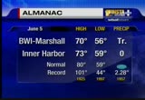
it is very spotty and scattered. there may be a lightning strike or two before all of this finally ends, and let's take a look at what has happened today. 76 was the high. baby was the high at the inner harbor. after 2:00 when the rain hit comedies temperatures dropped down. this was heavier at my house, well, 59 hundredths downtown, 9100 c on tv hill. you had to be under the storm to get the good rains. -- 9100 s on tv hill. it has not rain yet at ocean city, but they are likely to catch some. the shaded orange areas primarily west of the potomac river, they have had some sun this afternoon, and that drove the temperatures near 80 or so. here is the satellite pictures showing the clouds beginning to break up to the west of a but with the heavier clouds, with summering producers, especially up in these counties, including cecil county. there are some pretty big storms in pennsylvania. this is more scattered in western maryland at this time. once the front goes through, it may stall offshore, but the bulk of the rain
it is very spotty and scattered. there may be a lightning strike or two before all of this finally ends, and let's take a look at what has happened today. 76 was the high. baby was the high at the inner harbor. after 2:00 when the rain hit comedies temperatures dropped down. this was heavier at my house, well, 59 hundredths downtown, 9100 c on tv hill. you had to be under the storm to get the good rains. -- 9100 s on tv hill. it has not rain yet at ocean city, but they are likely to catch some....
116
116
Jun 5, 2012
06/12
by
WBAL
tv
eye 116
favorite 0
quote 0
spotty showers and cool temperatures. sunny skies friday, warmer weather over the weekend. 90 on monday. >> you can expect to pay more and for power. this according to a new survey by consulting and construction firm. 90% said there will be a spy. half of them reported the rise would be significant. the reason, rules requiring use of renewable energy and mandating at cut in pollution from coal-fired power plants. they predict an emphasis on solar power and surging electric cars. they expect electric cars will use 7% of the nation's power supply by 2025. an increase in the number of workers classified as involuntary part-timers. those workers would rather be working a full 40-hour week but they cannot because they are -- their employers are cutting back on hours or they cannot find a full-time job. the number of people working part-time climbed above 8 million last month. part-time jobs are little easier to come by. at least 14 looking for a paycheck this summer. the may jobs report shows an increase of 67,000 teenagers be
spotty showers and cool temperatures. sunny skies friday, warmer weather over the weekend. 90 on monday. >> you can expect to pay more and for power. this according to a new survey by consulting and construction firm. 90% said there will be a spy. half of them reported the rise would be significant. the reason, rules requiring use of renewable energy and mandating at cut in pollution from coal-fired power plants. they predict an emphasis on solar power and surging electric cars. they...
199
199
Jun 18, 2012
06/12
by
WJLA
tv
eye 199
favorite 0
quote 0
we may get some sunshine and showers through the back half of the day will be spotty. a lot of that stuff pushing through will take the energy out of here. not anticipating a wet afternoon. 66 degrees downtown right now 74 in pittsburgh, 75 in charleston 86 in indianapolis 87 in chicago, looking for highs near 100 degrees in chicagoland. the jet stream is well to the north and heat will build in for the next couple days and we will feel it. upper 80s by tomorrow. low to mid 90's on wednesday. mid to upper 90s on thursday. when you factor in the humidity, it will be sweltering in the coming days. there's a front down to our south and west. the clouds may spin-outs a little during the day today. tomorrow we will start the warming trend as the warm air starts to live in here. the heat and humidity will be pumping by wednesday. it will be rather hot and steaming across the area as the hot air moves in. sunshine may break through with a couple spotty showers today later, comfortable, partly cloudy. stay showers possible tonight, in the '60s. high and a little tomorrow, mid
we may get some sunshine and showers through the back half of the day will be spotty. a lot of that stuff pushing through will take the energy out of here. not anticipating a wet afternoon. 66 degrees downtown right now 74 in pittsburgh, 75 in charleston 86 in indianapolis 87 in chicago, looking for highs near 100 degrees in chicagoland. the jet stream is well to the north and heat will build in for the next couple days and we will feel it. upper 80s by tomorrow. low to mid 90's on wednesday....
257
257
Jun 5, 2012
06/12
by
WJLA
tv
eye 257
favorite 0
quote 0
a few more spotty showers possible later on today. it's 5:00 sharp. now to lisa. >> everything looks pretty smooth. it's good as far as the beltway. heading south into richmond and north into baltimore and to the airport. steve will tell you bought an accident that happened overnight in montgomery county. the road is still closed. we will give you details on that in a moment. first i will take you to 395 traffic, leaving the beltway is heading away from us in landmark. it's a beautiful ride up to the pentagon. back to you. >> thank you. new this morning a woman killed in a fiery car crash it happened in montgomery county. >> this was before 1:00 this morning on route 28 in poolesville at dickerson. emergency crews responded to reports of a woman trapped inside a burning car. if the trooper found her dead at the scene. the victim is not been identified and the investigation continues. howard county police have arrested four men in the math lab bust at a hotel room in maryland. officers got a call before 11:00 last night reporting there was a math lab i
a few more spotty showers possible later on today. it's 5:00 sharp. now to lisa. >> everything looks pretty smooth. it's good as far as the beltway. heading south into richmond and north into baltimore and to the airport. steve will tell you bought an accident that happened overnight in montgomery county. the road is still closed. we will give you details on that in a moment. first i will take you to 395 traffic, leaving the beltway is heading away from us in landmark. it's a beautiful...
371
371
Jun 25, 2012
06/12
by
WJZ
tv
eye 371
favorite 0
quote 0
spotty showers in here. these are the thunderstorms that have been coming through right now? right around millford into lewis and also south of ocean city. those are heading out to sea. so we will show you we had spotty showers and a thunderstorm or two during the overnight hours. and then this is associated with the cold front. once that clears the winds turn around to the northwest and bringing in that cooler dry her air at least temporarily. 77 where we sit right now in baltimore. we will go up a little bit morethis afternoon but the dew points will drop heading through the evening hours. here's a big look at everything going on. here's our front we are dealing with. but it's also interacting with debby the reason that debby is making that turn off to the east. debby has a lost the lot of strength but not size. look at the size of this. it's pulling in drier air on the western side and that's why it is losing some of the strength. another reason that front approaching is mixing up the atmosphere so it can't ventilate and become larger but the thing is it's doing the damage
spotty showers in here. these are the thunderstorms that have been coming through right now? right around millford into lewis and also south of ocean city. those are heading out to sea. so we will show you we had spotty showers and a thunderstorm or two during the overnight hours. and then this is associated with the cold front. once that clears the winds turn around to the northwest and bringing in that cooler dry her air at least temporarily. 77 where we sit right now in baltimore. we will go...
180
180
Jun 5, 2012
06/12
by
WTTG
tv
eye 180
favorite 0
quote 0
for us, keep a spotty shower possible, mainly west of town.ted you to see those last night and that is chilly across the region and drop to 58 in washington. gaithersburg, up to 54 and athens, 60 and most areas down into the 50s and i think we're going to do that again tonight. we bounced up to 71 at reagan and dulles and bwi70. north and west of town, stay put to the upper 60s. and that is when we find most of our temperatures at this hour with a few spots to the south still and a lot of 50s. as the clouds break up later tonight, we'll definitely head back to the 50s and can you see the cooler air in the northeast and mid-atlantic and all of that yellow shows us the warmer air that is off to the west and that will get in here as soon as the roadblock happens on friday and at 7:00 68 degrees, a spotty shower west. by 9:00, 64 and by 11:00, 61 degrees and we're headed for a chilly night once again, and with some temperatures fallling into the 50s and for some of you, low 50s at that and this is your five-day forecast. we're going for a temperat
for us, keep a spotty shower possible, mainly west of town.ted you to see those last night and that is chilly across the region and drop to 58 in washington. gaithersburg, up to 54 and athens, 60 and most areas down into the 50s and i think we're going to do that again tonight. we bounced up to 71 at reagan and dulles and bwi70. north and west of town, stay put to the upper 60s. and that is when we find most of our temperatures at this hour with a few spots to the south still and a lot of 50s....
166
166
Jun 18, 2012
06/12
by
WTTG
tv
eye 166
favorite 0
quote 0
in some evening hours and overnight and that is on the cool side. 63 in the district and with some spotty evening shower and the winds out of the southeast and that is on the cool side. pop up to 87 degrees and that is some humidity, brighter than today and because it's getting hot, an isolated afternoon thunderstorm is possible and into that day planner, 74 at 8 in the morning and a spotty shower. by 91, 83; by 5:00, 86 and that is when we work into it. as we head into wednesday issue we jump to 95. by thursday, 98 and some storms on friday at 93 and some relief for the weekend. we noticed it before and sometimes the relief doesn't get here and that is like having a brick wall in the atmosphere and hope that the cool down into the 80s. >>> and web simpson may have been an unlikely winner this weekend at the united states open. maybe some are more surprising is how this guy interrupted the celebration. lindsay murphy is next with that story. >>> and down the coast to san diego. the canines stick to the waves in san diego. part of the annual surfing competition over the weekend. more than
in some evening hours and overnight and that is on the cool side. 63 in the district and with some spotty evening shower and the winds out of the southeast and that is on the cool side. pop up to 87 degrees and that is some humidity, brighter than today and because it's getting hot, an isolated afternoon thunderstorm is possible and into that day planner, 74 at 8 in the morning and a spotty shower. by 91, 83; by 5:00, 86 and that is when we work into it. as we head into wednesday issue we jump...
216
216
Jun 1, 2012
06/12
by
WTTG
tv
eye 216
favorite 0
quote 0
we'll be mile overnight, partly cloudy, a spotty -- mild overnight, partly cloudy, a spotty shower can'truled out. it's the stronger area of low pressure that will move up and through the great lakes that will drag a front through here and late day strong storms are in the forecast. i think it will be in two waves, the first one beginning right around 4:00 or so. that's why the storm prediction says from central pennsylvania down to the carolinas we've got to watch these storms because of the potential for hail, high winds, maybe isolated tornadoes and some very heavy rain. overnight just an isolated shower and temperature 63 degrees. we get up to 84 degrees tomorrow. you will notice the humidity definitely going to increase as opposed to the buffe day today. then we watch for -- beautiful day today. then we watch for strong thunderstorms. let's see what's going on with these showers and symptoms on futurecast. by 1:00 -- storms on futurecast. by 1:00 not much. by 5:00 you see thunderstorms popping up and 10:00, 11:00, 12 clock is when the front comes -- 12:00 is when the front comes thr
we'll be mile overnight, partly cloudy, a spotty -- mild overnight, partly cloudy, a spotty shower can'truled out. it's the stronger area of low pressure that will move up and through the great lakes that will drag a front through here and late day strong storms are in the forecast. i think it will be in two waves, the first one beginning right around 4:00 or so. that's why the storm prediction says from central pennsylvania down to the carolinas we've got to watch these storms because of the...
206
206
Jun 21, 2012
06/12
by
WTTG
tv
eye 206
favorite 0
quote 0
the possibility of a forecast or thunderstorm in the forecast on sunday, but it's just shale one, a spotty storm and -- a small one, a spotty storm and certainly a lot more reasonable in the temperature department. speaking of more reasonable, yes, we've got our hot days coming, we just talked about saturday and sunday, but monday with some showers in the forecast, our temperature may drop below average to 83 degrees. it's not a terribly long stretch of very hot days. that is it for weather. >>> but we had some very good fans show up for the rays and nats. dave ross has more. >> this is the verizon 4g lte sports desk with dave ross. >> thank you. this rays and nationals series heated up in a hurry. after last night's glove gate game ray's manager joe maddon said davey johnson's action were cowardly and bogus to which david retorted i don't want to get in a shouting match with joe. i looked up on the internet and found out he has a tweeter, so he can get more people than me. you can't make this stuff up. there's davey and madden, no tweeting. 1st inning bryce harper with a man on and steve
the possibility of a forecast or thunderstorm in the forecast on sunday, but it's just shale one, a spotty storm and -- a small one, a spotty storm and certainly a lot more reasonable in the temperature department. speaking of more reasonable, yes, we've got our hot days coming, we just talked about saturday and sunday, but monday with some showers in the forecast, our temperature may drop below average to 83 degrees. it's not a terribly long stretch of very hot days. that is it for weather....
135
135
Jun 5, 2012
06/12
by
WUSA
tv
eye 135
favorite 0
quote 0
spotty showers this afternoon. best chance will be west of town in the higher elevations as you get toward the blue ridge and west of there. at 8:00 still should be partly sunny and 69 with the transfer of venus late this afternoon in front of the sun, if you're going to try to watch that, don't look directly at the sun, i think most of us will be able to check that out. here's a look at the temperature letters oaf -- at the dopplers over the last six years. right down coastal areas along the bay and around d.c. and points south seeing a few showers. we still have showers in north beach and solomons. out to the west the heavier showers now southeast of fredricksburg pulling away. but a couple of sprinkles here and there and a little bit of drizzle. the temps are in the 50s north to a couple of low 60s at fredricksburg or the lone low 60 i should say in fredricksburg. 55 in winchester. good visibility. had some drizzle and light sprinkles on the hour at national, 59 degrees with a north, northeasterly wind at 7 and
spotty showers this afternoon. best chance will be west of town in the higher elevations as you get toward the blue ridge and west of there. at 8:00 still should be partly sunny and 69 with the transfer of venus late this afternoon in front of the sun, if you're going to try to watch that, don't look directly at the sun, i think most of us will be able to check that out. here's a look at the temperature letters oaf -- at the dopplers over the last six years. right down coastal areas along the...
187
187
Jun 11, 2012
06/12
by
WUSA
tv
eye 187
favorite 0
quote 0
we've got some clouds out there and a couple spotty showers generally south of us and to the west. so most of us are probably staying dry through this evening. we see a couple areas of showers towards gaithersburg and fairfax and these are not long lasting showers. right now cloudy skies, 84 degrees, dew point in the lower 60s. so young it's still sticky out there. it is 80 -- yup, it's still sticky out there. it's 80 at andrews air force base, 77 manassas, 73 leesburg, 72 winchester, culpeper 73, annapolis 83 degrees. what is going on? out to the west we've got a cold front approaching tomorrow which will bring us eventually cooler drier air, but with the front we're talk unsettled conditions and it will be cooler come tomorrow. for tonight isolated thunderstorm or shower. then tomorrow showers and storms are likely. those storms could also produce some pretty heavy rain, so flash flooding is possible. then get ready for some drier air for wednesday. you don't like the muggies, you'll like the next couple days. our 9 futurecast, tomorrow morning at 8:00 we've got light rain which
we've got some clouds out there and a couple spotty showers generally south of us and to the west. so most of us are probably staying dry through this evening. we see a couple areas of showers towards gaithersburg and fairfax and these are not long lasting showers. right now cloudy skies, 84 degrees, dew point in the lower 60s. so young it's still sticky out there. it is 80 -- yup, it's still sticky out there. it's 80 at andrews air force base, 77 manassas, 73 leesburg, 72 winchester, culpeper...
111
111
Jun 12, 2012
06/12
by
WTTG
tv
eye 111
favorite 0
quote 0
i will describe them as spotty and that is going to be an east wind and that will keep the temperature in check and they'll be closer to the 80, low 80s the rest of the week and that is going to provide more and today's high temperature in the upper 70s, well below the average and which is in some low 80s this time of the year. temperatures actually jumped up to 77 degrees and that is some spots sunnier and culpeper at 81 and we will eventually get some cooler air coming in to town after the front crosses and that is going to be longer. the cooler breeze will come courtesy of high pressure and that is bringing in the northwest flow. the frontal system is moving off of the coast and into that wednesday, we'll see this high and the area of low pressure bringing in the east wind and some spotty somehow or thursday and that is not a washout. an evening shower or storm possible, 69 degrees and tomorrow, the sunshine returns with a gusty breeze, a temperature of 81 degrees and this is that five-day forecast. 79 on thursday and a temperature on friday of 81 and right now, this is looking like
i will describe them as spotty and that is going to be an east wind and that will keep the temperature in check and they'll be closer to the 80, low 80s the rest of the week and that is going to provide more and today's high temperature in the upper 70s, well below the average and which is in some low 80s this time of the year. temperatures actually jumped up to 77 degrees and that is some spots sunnier and culpeper at 81 and we will eventually get some cooler air coming in to town after the...
224
224
Jun 7, 2012
06/12
by
WTTG
tv
eye 224
favorite 0
quote 0
tomorrow a lot like today with a spotty shower or thunderstorm in the afternoon, temperature tomorrow up to about 80 degrees. high today officially was 75. 64 tomorrow morning, 75 by lunchtime, a spotty shower by 5 p.m., temperature right around 79 by 5:00, but we may get to 80 for a high, friday warmer, mostly sunshine, 83 and again as we get into the weekend expect temperatures to warm up to the upper 80s into the lower 90s. here's a look at your forecast. >>> now we switch over to sports with lindsay murphy. >> this is the verizon 4g lte sports desk with lindsay murphy. >> hello, everybody. the redskins have stolen the headlines again announcing today the team will move training camp next season to richmond. redskins gm bruce allen and virginia governor bob mcdowell announced the changes this afternoon. they have not decided on the practice site. governor mcdonnell also approved a $4 million base grant to help keep the team in virginia. corporate headquarters will stay in loudoun county and redskins park will expand. bruce allen mentioned improvements at redskins park will include
tomorrow a lot like today with a spotty shower or thunderstorm in the afternoon, temperature tomorrow up to about 80 degrees. high today officially was 75. 64 tomorrow morning, 75 by lunchtime, a spotty shower by 5 p.m., temperature right around 79 by 5:00, but we may get to 80 for a high, friday warmer, mostly sunshine, 83 and again as we get into the weekend expect temperatures to warm up to the upper 80s into the lower 90s. here's a look at your forecast. >>> now we switch over to...
91
91
Jun 6, 2012
06/12
by
WTTG
tv
eye 91
favorite 0
quote 1
the temperature is up to 80 degrees and, yes, we'll have that ever-persistent chance of a spotty showernd late afternoon thunderstorm. and next five days, that is probably going to go away on friday and friday looks fairly dry. the high pressure begins to build in for the weekend and that is go to el the -- elevate the temperatures a bit. 87 on saturday; 91, sunday. at least a chance this being w brian -- this weekend, brian, for late-day, early evening showers and thunderstorms. we're in what is called a northwest flow and wveof a stor there. >>> and check out the weather any time g. to apples app and mark it on the smart phone and search for d.c. weather. >>> the shuttle enterprise arrived at the final destination and a permanent picture here in new york. fox's lauraingal has details on the long trip. >> reporter: enterprise flew from washington to new york on april 27th and stayed at jfk international airport until sunday. while the space shuttle was being transported from the airport to weeks marine shipyard in new jersey, a gust of wind caused one of the wings to scrape against a r
the temperature is up to 80 degrees and, yes, we'll have that ever-persistent chance of a spotty showernd late afternoon thunderstorm. and next five days, that is probably going to go away on friday and friday looks fairly dry. the high pressure begins to build in for the weekend and that is go to el the -- elevate the temperatures a bit. 87 on saturday; 91, sunday. at least a chance this being w brian -- this weekend, brian, for late-day, early evening showers and thunderstorms. we're in what...
181
181
Jun 13, 2012
06/12
by
WTTG
tv
eye 181
favorite 0
quote 0
thursday is an increase in cloud cover and a very slight chance for a spotty shower, again best chance east and south of d.c. i'm liking the looks of friday, saturday and sunday. could that possibly be award winning? let's hope. so have a good night. >>> slow progress for crews battling wildfires in new mexico and colorado. one person has died from the smoke. her remains were later found in her burned out home. there are more than 500 crews on the scene near ft. collins colorado. more are still on the way. the fire has burned up to 68 square miles. >>> a west virginia woman is on a walk to remember. annie wisegarver is hiking the entire appalachian trail all with the help for others. when she's done, she will have walked more than 2,000 miles through 14 states. fox 5's photojournalist lance ing had a chance to camp up with her passing through from -- catch up with her passing through frederick county. >> always enjoyed hiking, camping, backpacking. i sold my truck. i left my truck. i gave up my apartment and i had a little apartment, so i just put a few things in storage and gave a wav
thursday is an increase in cloud cover and a very slight chance for a spotty shower, again best chance east and south of d.c. i'm liking the looks of friday, saturday and sunday. could that possibly be award winning? let's hope. so have a good night. >>> slow progress for crews battling wildfires in new mexico and colorado. one person has died from the smoke. her remains were later found in her burned out home. there are more than 500 crews on the scene near ft. collins colorado. more...
202
202
tv
eye 202
favorite 0
quote 0
folks around there, spotty light showers.'s one little bitty shower that just died around the leesburg area. so just enough to give you a few drops. here's temperatures throughout the east. we're at 69 now. 72 in raleigh. it's been cool here too. that same pattern. giving locations down south through carolina. 75 degrees even in atlanta, georgia. 79 in jacksonville, florida. for the nation's midsection, there's your 80s and low 90s. we're going to see our pattern flip as we get to the end of this week. and move through the weekend. till then, hey, let's get through the evening and tomorrow morning. 65 degrees by 11:00 p.m. can't rule out an isolated shower. really not a big deal. 58 to 59 degrees for early tomorrow morning. i think unlike this morning, we're going to have more sunshine. right now, it is looking dry. we start out at 6:00 a.m. this morning. the northeast satellite and radar, you can see where most of the rain has been down south. here, just spotty showers. even up into pennsylvania. around new jersey and around
folks around there, spotty light showers.'s one little bitty shower that just died around the leesburg area. so just enough to give you a few drops. here's temperatures throughout the east. we're at 69 now. 72 in raleigh. it's been cool here too. that same pattern. giving locations down south through carolina. 75 degrees even in atlanta, georgia. 79 in jacksonville, florida. for the nation's midsection, there's your 80s and low 90s. we're going to see our pattern flip as we get to the end of...
172
172
Jun 13, 2012
06/12
by
WTTG
tv
eye 172
favorite 0
quote 1
we're going to have a few more clouds than what we had today and there may be a spotty sprinkle hereere and that does not mean a bad day. 81 degrees. gaithersburg, 75; dulles, 79 and down in fredericksburg, the temperature is at 81 and just a great evening out there and we're talking about the dry conditions. 77 at 7:00 and to 9:00, temperatures fallling into the lower 70s and in some suburbs, the upper 60s and that may be a pretty descent night to turn off the air conditioning and if you haven't already, enjoy the nice fresh air. in the suburbs, the temperatures are drop into this 50s and that five-day forecast and that is looking good. father's day this weekend. >> love it. see you soon. thanks. >>> >>> weather not good in other parts of the country. the huge fire in northern colorado is blowing is wyoming tonight. the third largest in colorado history, burning 73 square miles. it's killed one person so far and right now, it's about 10% contained but firefighters have been making slow progress. investigators say a lightning strike touched off the flames. >>> and in new mexico, almo
we're going to have a few more clouds than what we had today and there may be a spotty sprinkle hereere and that does not mean a bad day. 81 degrees. gaithersburg, 75; dulles, 79 and down in fredericksburg, the temperature is at 81 and just a great evening out there and we're talking about the dry conditions. 77 at 7:00 and to 9:00, temperatures fallling into the lower 70s and in some suburbs, the upper 60s and that may be a pretty descent night to turn off the air conditioning and if you...
68
68
Jun 4, 2012
06/12
by
WJLA
tv
eye 68
favorite 0
quote 0
we cannot rule out a few spotty light showers or sprinkles here and there. every day through thursday. it will be unseasonably cool, about 10 degrees below average tomorrow. we have an upper level low pressure systems with scattered rain around that low and we will see that energy that dips down into washington periodically the next several days and that will lead to the light showers every day. we have a 40% chance of rain today, tomorrow, all the way through thursday with that cool and unsettled weather pattern. we're not looking it anything severe. , just a few spotty showers and tomorrow will be even cooler down today. better pool whether by the weekend >> >> heavy volume of traffic here and there but nothing that would be surprising. weekend road work is gone. for the wilson bridge drivers out of maryland. we will take a lie to the geico traffic center camera on 395 north of the beltway. it is moving at speeds. >> 6:20 and outside the temperature is around 60 degrees. >> coming up next, another overtime game between the miami heat in the boston celtics.
we cannot rule out a few spotty light showers or sprinkles here and there. every day through thursday. it will be unseasonably cool, about 10 degrees below average tomorrow. we have an upper level low pressure systems with scattered rain around that low and we will see that energy that dips down into washington periodically the next several days and that will lead to the light showers every day. we have a 40% chance of rain today, tomorrow, all the way through thursday with that cool and...
183
183
Jun 29, 2012
06/12
by
KPIX
tv
eye 183
favorite 0
quote 0
the dmv website has been spotty 4 days. it is almost impossible to register online. and if they do not get there on time, they meet based registration fees. >>> we will have to show up in person to get the finest removed. >>> the dmv says they will work with customers that faced late fees because of the problems by a case by case condition. >>> and the state is allocating more funds and deals have been reached, >>> the uncertainty of not knowing what was going to happen was really scary. >>> reserve science for campsites are ready up for the fourth of july week and people will be allowed to use them in the foreseeable future. >>> and a houseboat is trying complains from neighbors on land. the owner hopes to transform it to a floating moneymaker. he tied it near a park in the home owners association complained to the city. and it's the one and tied in it floated out >>> he face he could throw his boat out to this than big where and at the coast guard will allow him to tell it and encourage it offshore. >>> looks into the next generation room model could look like. >>>
the dmv website has been spotty 4 days. it is almost impossible to register online. and if they do not get there on time, they meet based registration fees. >>> we will have to show up in person to get the finest removed. >>> the dmv says they will work with customers that faced late fees because of the problems by a case by case condition. >>> and the state is allocating more funds and deals have been reached, >>> the uncertainty of not knowing what was...
419
419
Jun 18, 2012
06/12
by
WJZ
tv
eye 419
favorite 0
quote 0
. >> today spotty shoufrs in the forecast.hrough the afternoon. 78, spotty showers will hang around. far check of the reds -- for a check of the roads we send it to sharon gibala. >>> good morning. if you are just about the head out, an sdernts on the inner -- an accident on the inner loop. an sdnt in the joppa area at fraiveng lynn road. there's -- franklin road. there's a live like at the west side of the beltway. it looks like some rain there. there's another live look at the west side. this traffic report is brought to you by home paramount pest control. don, fwook you. >>> -- back to you. >>> this is a big day in the commemoration of the war of 1812. mike schuh has the story. >> reporter: good big day here at the fort. this ceremony upon which this entire celebration was built. over the weekend two performances from the blue angels, the bso honored sailabration with oh overture of 2012. between the great weather an the governor rejoining his band, these have been days to remember. now, today at 11:00 the ceremony commemor
. >> today spotty shoufrs in the forecast.hrough the afternoon. 78, spotty showers will hang around. far check of the reds -- for a check of the roads we send it to sharon gibala. >>> good morning. if you are just about the head out, an sdernts on the inner -- an accident on the inner loop. an sdnt in the joppa area at fraiveng lynn road. there's -- franklin road. there's a live like at the west side of the beltway. it looks like some rain there. there's another live look at the...
 Live Music Archive
 Librivox Free Audio
 Metropolitan Museum
 Cleveland Museum of Art
 Internet Arcade
 Console Living Room
 Open Library
 American Libraries
 TV News
 Understanding 9/11