241
241
Nov 18, 2012
11/12
by
KRON
tv
eye 241
favorite 0
quote 0
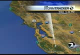
as we take a look at stormtracker 4.tty showers for martinez, antioch but that will clear out pretty soon. taking a look at it that cold spot. 40's but we are starting to see things clear up already in the 50s in oakland and 47 degrees in sunnyvale. as we take a look at the futurecast we will go forward to about 10:00 a.m. with widespread 50s. and 60s and it is going to be another cool day. by 8:00 p.m., a mixture of 50s and even 40's, inland. let us start in the south bay. cupertino. and for the east bay inland valleys. also low 60s for the east bayshore. and upper 60s for mean as we turn our attention to the satellite and writer. this system is impacting the pacific for northwest and as well as the northern portion of our state. that could push as far as the north bay shower activity this week widespread. tuesd by thanksgiving and your holiday weekend. the time right now is 8:17 >> new this morning president obama is in thailand on a three day trip to asia. the trip is in an effort to boost economic and political relat
as we take a look at stormtracker 4.tty showers for martinez, antioch but that will clear out pretty soon. taking a look at it that cold spot. 40's but we are starting to see things clear up already in the 50s in oakland and 47 degrees in sunnyvale. as we take a look at the futurecast we will go forward to about 10:00 a.m. with widespread 50s. and 60s and it is going to be another cool day. by 8:00 p.m., a mixture of 50s and even 40's, inland. let us start in the south bay. cupertino. and for...
560
560
Nov 1, 2012
11/12
by
WTTG
tv
eye 560
favorite 0
quote 0
stormtracker center. >> what's good, man? >> mater o'hara, he was randy on "the wire." >> you excited disney is taking over george lucas, "star wars? >> that's awesome. >> oh, my god. abby and brittany. >> what? >> that girl over there is dressed like the conjoined twins. you know the twins abby and brittany. >> i'm brittany and this is abby. >> could you introduce who you really are? >> i'm dax's intern. >> dax is always having someone work for him. what do you do? >> everyone has interns. >> no wonder he has 5,000 twitter fans. it's all >> twins. >> vagina grave wednesday, vagina grave wednesday, yeah! >> with celebrity props rex lee. >> one question for you. >> ok. >> the guy in serbia, his wife passed away. on her headstone, he puts a carving of her vagina. >> yes, this odd etching is quickly becoming the most famous serbian made cavity since ferdinand gunshot wound. >> she wanted this on her head set. >> what is the motivation? >> she wanted it on her headstone and she was passing away. and she says, this way you will al
stormtracker center. >> what's good, man? >> mater o'hara, he was randy on "the wire." >> you excited disney is taking over george lucas, "star wars? >> that's awesome. >> oh, my god. abby and brittany. >> what? >> that girl over there is dressed like the conjoined twins. you know the twins abby and brittany. >> i'm brittany and this is abby. >> could you introduce who you really are? >> i'm dax's intern. >> dax is...
171
171
Nov 15, 2012
11/12
by
KTVU
tv
eye 171
favorite 0
quote 0
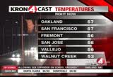
there is live "stormtracker," showing you clouds as well. radar coming off the national weather service radar. it's not showing anything now, but when you come back here tomorrow night, late, maybe after 11:00. i think we are showing some showers up here in the north bay. the current temperature, 61 in fairfield. 62 in napa. 70s around the bay, check out the current in half moon bay. why is it so warm in half moon bay? lowest level you are, it's the warmest location. half moon bay is at sea level. san francisco, more room to compress, the more it many whats. forecast highs, cooler, more clouds, cloud cover, 71 in santa rosa, 6 in san mate o, 72 in oakland, the highs today, highs tomorrow coming off a few degrees. mostly cloudy to partly cloudy skies by the afternoon. late tomorrow night, we bring some sprinkles and showers in the forecast, late, 3:00 or 4:00 in the morning. that has an impact on your friday morning commute. as you look at the sat lied image, you can see some southerly moisture moving in. this is the system i'm tracking right
there is live "stormtracker," showing you clouds as well. radar coming off the national weather service radar. it's not showing anything now, but when you come back here tomorrow night, late, maybe after 11:00. i think we are showing some showers up here in the north bay. the current temperature, 61 in fairfield. 62 in napa. 70s around the bay, check out the current in half moon bay. why is it so warm in half moon bay? lowest level you are, it's the warmest location. half moon bay is...
155
155
Nov 30, 2012
11/12
by
KRON
tv
eye 155
favorite 0
quote 0
this is a live look at the stormtracker 4 radar.cqueline will be back with the forecast. >> coming up by what take a look at the bicycle lanes and balenciaga. why they are the focus on the next edition of people behaving badly in -- colise valencia (male announcer): now, here's stanley roberts who found people behaving badly. valencia street in san this is a fex ex big rig also double parked on valencia street just a few blocks away in fact if you drive up and not hard to find double parkers but these are not your average double parkers, these drivers are blocking the bike lanes, lanes set aside just for bicylist its like they don't care about us you know it's like if i go arould the guy im gonna get hit they don't care they always do that it wasn't hard for me to find drivers blocking the dedicated bike lanes, even with the threat of a 113 dollar parking ticket blinker on while crusing in the bike lane to be fair a lot of the truck driver are now using the center median to park rather than blocking the bike lanes although after tal
this is a live look at the stormtracker 4 radar.cqueline will be back with the forecast. >> coming up by what take a look at the bicycle lanes and balenciaga. why they are the focus on the next edition of people behaving badly in -- colise valencia (male announcer): now, here's stanley roberts who found people behaving badly. valencia street in san this is a fex ex big rig also double parked on valencia street just a few blocks away in fact if you drive up and not hard to find double...
227
227
Nov 10, 2012
11/12
by
KRON
tv
eye 227
favorite 0
quote 0
would hayward, as would a live look outside on stormtracker 4 radar. a >> coming up later this of ratio on a friday night. >> i am here. >> alicea and the warriors are coming up with the latest sports coming up >> a berkeley based optical technology company has made a huge breakthrough. it is about to release on to the market a new type of glasses that can help people are color blind. see colors more accurately for the first time. here is an example whiff gabe slate tech report >> it is estimated that over 10 million americans suffer from color to fissio color blin- >> one of the greatest establishments and satisfaction that i've had in my career as taking somebody that is colored deficient and it is always so great when it they will say that is that color of that flower violet? they will see a stop sign of much more clearly, five, six, seven blocks away. >> after several months of development these color enhanced could be prescription or regular. >> these are normal, red, green, blue perception and when you put these on the will of-the enhanced. >> an
would hayward, as would a live look outside on stormtracker 4 radar. a >> coming up later this of ratio on a friday night. >> i am here. >> alicea and the warriors are coming up with the latest sports coming up >> a berkeley based optical technology company has made a huge breakthrough. it is about to release on to the market a new type of glasses that can help people are color blind. see colors more accurately for the first time. here is an example whiff gabe slate tech...
180
180
Nov 17, 2012
11/12
by
KRON
tv
eye 180
favorite 0
quote 0
stormtracker 4 we're watching the rain fall and were used to the green. the yellow is indicating heavier rainfall but it is heavier in the north but not as much in the south bay. and some of green you through in sunnyvale, cupertino, milpitas and the lalmadden valley and the heavy rainfall is sometimes to the santa cruz mountains. and generally light through san francisco. and along the coast but as i mentioned the heavy rainfall is right. for marin county hill was for west marin, would incur, san rafael, catching some of that yellow card and the h ills and the live look at the span of the san mateo bridge and the core is working its way on the shore. the heaviest will be north. shower activity early. however there will be a break but there is another system, the second storm system for the saturday evening that will bring more rainfall for a saturday morning. the first storm is pretty much onshore but still heaviest over the ocean. storm no. 2, will be near the afternoon and evening. the futurecast showing snowfall there could be 6 in.-12 in. for locatio
stormtracker 4 we're watching the rain fall and were used to the green. the yellow is indicating heavier rainfall but it is heavier in the north but not as much in the south bay. and some of green you through in sunnyvale, cupertino, milpitas and the lalmadden valley and the heavy rainfall is sometimes to the santa cruz mountains. and generally light through san francisco. and along the coast but as i mentioned the heavy rainfall is right. for marin county hill was for west marin, would incur,...
409
409
Nov 1, 2012
11/12
by
KRON
tv
eye 409
favorite 0
quote 0
>>jacqueline: the rainfall is certainly coming down in the stormtracker 4 radar. the weather cells down to the delta of. and to the north bay. look with heavy rainfall falling near santa rosa for the last couple of hours. and also heavy rainfall skirting napa at this hour and moving on shore. with stinson beach, san rafeal and lighter near san francisco. the weather headlines will show spotty showers in nature, overnight. we could see some weather cells that are perhaps more moderate. tomorrow, a decrease in cloud coverage in the temperatures will be cool. warmer weather as we go towards the weekend. the satellite and radar showing that this main band of rain pushing through the rain. be 3-e could be frontal showers in future cast by 10:00 p.m. moderate through san francisco, vallejo, and stretching to the east today. midnight, notice it is south of the golden gate but still, light. those showers i mentioned could be lingering. those will occur in the north bay and press down to san francisco and the coast. as you head out tomorrow you could contend with wet weath
>>jacqueline: the rainfall is certainly coming down in the stormtracker 4 radar. the weather cells down to the delta of. and to the north bay. look with heavy rainfall falling near santa rosa for the last couple of hours. and also heavy rainfall skirting napa at this hour and moving on shore. with stinson beach, san rafeal and lighter near san francisco. the weather headlines will show spotty showers in nature, overnight. we could see some weather cells that are perhaps more moderate....
301
301
Nov 21, 2012
11/12
by
KRON
tv
eye 301
favorite 0
quote 0
stormtracker 4, with spotty showers. and heavy rainfall year santa rosa. light.he futurecast. with santa rosa possibly more by 8:00 p.m. and a little bit of what we're seeing right now with spotty showers by a 11:00 p.m. there rain will start to press after the overnight hours. and heavy rainfall per oakland, the san mateo coast and delta. most of this will be concentrated south of the golden gate. by 10:00 p.m., dry conditions over the north bay. and throughout the entire bay area by 1:00. clearing skies for the evening. it had a and -- try conditions. this year conditions looking live. with a dry conditions even by 10:00 a.m. and right now, we are looking for snowfall in the sierras, not snowfall cold front presses through we will see snowfall at $7.200 feet. draw your weather it in this year is expected. when what take a look at your snow report. kirkwood has 36 in., andwww.snowbomb.com for complete details with the morning rainfall and afternoon clearing. for thursday, friday, agreweather conditions 50 slight cool down for early next week. >> let us take a lo
stormtracker 4, with spotty showers. and heavy rainfall year santa rosa. light.he futurecast. with santa rosa possibly more by 8:00 p.m. and a little bit of what we're seeing right now with spotty showers by a 11:00 p.m. there rain will start to press after the overnight hours. and heavy rainfall per oakland, the san mateo coast and delta. most of this will be concentrated south of the golden gate. by 10:00 p.m., dry conditions over the north bay. and throughout the entire bay area by 1:00....
138
138
Nov 15, 2012
11/12
by
KICU
tv
eye 138
favorite 0
quote 0
as you can see from live stormtracker 2, showing clouds right now. things are changing around. here's system number 1. here's system number 2. system number 1 gets in here as we go into tomorrow night, friday morning. it's a low latitude storm. see how far south it is? system number 2 is coming from the polar regions. that gets here over the night saturday night into sunday morning. system number 1 wetter. system number 2 cooler. that makes sense right? as we go into the next few days, that's what's happening. the atmosphere is changing around. we're going into an unsettled weather climate. looking for scattered showers as we head into friday. clouds increase tomorrow. not a bad day. maybe some drizzle late in the afternoon. then overnight thursday, into friday morning the showers start. friday morning's commute looks like it's going to be a little bet wet out there. friday afternoon's commute looks like it's going to be wet. that's friday. thursday looks nice. today was a nice day, tomorrow will be a nice day. then we get into system number 1 friday. maybe a half inch of rain
as you can see from live stormtracker 2, showing clouds right now. things are changing around. here's system number 1. here's system number 2. system number 1 gets in here as we go into tomorrow night, friday morning. it's a low latitude storm. see how far south it is? system number 2 is coming from the polar regions. that gets here over the night saturday night into sunday morning. system number 1 wetter. system number 2 cooler. that makes sense right? as we go into the next few days, that's...
209
209
Nov 17, 2012
11/12
by
KRON
tv
eye 209
favorite 0
quote 0
. >> the stormtracker has been heavy. with a san rafael getting busy with rainfall, and panel. of moving to the east and towards vallejo and fennel. >> and with the butt of a break for a pane for san francio but take a look at panpanel an.. our activity if at pinole. with santa rosa, nearly one half inch that is for the amounts have been the highest. san jose, hardly just traces. the center of the storm is now on top of oz. we are going to get the heaviest rainfall in the next hour is on top of lost- and it could lighten up towards the morning. by tomorrow, we will see a break after this first system. that great a late morning early afternoon but that the second system will ride. here is futurecast at midnight. noting it will arrive. -- by the north bay, is on its way out of but bought the dry weather on mid-day. that is one that next band will come in with a steady rainfall for the evening. showers lingering on this sunday. that is what we could see your kron 4 7 day around the bay however by the afternoon i think that we will have a nice mix of clouds and sunshine. dry weathe
. >> the stormtracker has been heavy. with a san rafael getting busy with rainfall, and panel. of moving to the east and towards vallejo and fennel. >> and with the butt of a break for a pane for san francio but take a look at panpanel an.. our activity if at pinole. with santa rosa, nearly one half inch that is for the amounts have been the highest. san jose, hardly just traces. the center of the storm is now on top of oz. we are going to get the heaviest rainfall in the next hour...
231
231
Nov 16, 2012
11/12
by
KRON
tv
eye 231
favorite 0
quote 0
stormtracker 4, there is definitely rainfall right now. so fog just rainfall, that satellite and radar and with light green offshore that we just saw on the radar. and we can still see plenty of rainfall to the self this is and a couple of different areas the east could be impacting us first, this one tomorrow. as we take a look it futurecast will see that the cloud coverage to the 8:00 hour. even on friday, but the widespread wide rainfall will be into the commute in the afternoon will time it out on futurecast with snowfall and the sierras. >> international news we good-looking and all out a ground war pretty soon between the israeli and palestinian militants in gaza uk is see this chaos. they say that palestinian militants aimed more than 200 rockets towards israel today three of those targeting the densely populated tel aviv. israel reports that three people have died and 18 of the errors were owned killed and the israeli military is moving up to 30,000 troops to the israeli cause of strip border is reall gaza in preparation for a grou
stormtracker 4, there is definitely rainfall right now. so fog just rainfall, that satellite and radar and with light green offshore that we just saw on the radar. and we can still see plenty of rainfall to the self this is and a couple of different areas the east could be impacting us first, this one tomorrow. as we take a look it futurecast will see that the cloud coverage to the 8:00 hour. even on friday, but the widespread wide rainfall will be into the commute in the afternoon will time it...
315
315
Nov 15, 2012
11/12
by
KTVU
tv
eye 315
favorite 0
quote 0
as you can see from live stormtracker 2, showing clouds right now. things are changing around.e's system number 1. here's system number 2. system number 1 gets in here as we go into tomorrow night, friday morning. it's a low latitude storm. see how far south it is? system number 2 is coming from the polar regions. that gets here over the night saturday night into sunday morning. system number 1 wetter. system number 2 cooler. that makes sense right? as we go into the next few days, that's what's happening. the atmosphere is changing around. we're going into an unsettled weather climate. looking for scattered showers as we head into friday. clouds increase tomorrow. not a bad day. maybe some drizzle late in the afternoon. then overnight thursday, into friday morning the showers start. friday morning's commute looks like it's going to be a little bet wet out there. friday afternoon's commute looks like it's going to be wet. that's friday. thursday looks nice. today was a nice day, tomorrow will be a nice day. then we get into system number 1 friday. maybe a half inch of rain in t
as you can see from live stormtracker 2, showing clouds right now. things are changing around.e's system number 1. here's system number 2. system number 1 gets in here as we go into tomorrow night, friday morning. it's a low latitude storm. see how far south it is? system number 2 is coming from the polar regions. that gets here over the night saturday night into sunday morning. system number 1 wetter. system number 2 cooler. that makes sense right? as we go into the next few days, that's...
202
202
Nov 9, 2012
11/12
by
KRON
tv
eye 202
favorite 0
quote 0
the stormtracker 4 with spotty showers.ards the north bay and along the coast and bodega bay and the peninsula. pierre menlo park and palo alto and east palo alto. the heavier rainfall and east palo alto. heavier rainfall towards union city. and over the 880 right now. the satellite, with a spotty showers as we go overnight the main band of rainfall is this. you can see that it is fragmented. it is not that organized but that is what brought us the first round of rainfall. that spotty pattern indicates what we're going to see. shiner thundershowers and even snowfall through the sierras with heavy. at this hour. we will continue to see that tonight and tomorrow. we will time it out on futurecast and take a look at your weekend forecast, coming up. >>pam: kron 4 is tracking this wet weather or live coverage continues with j are stoned. j.r.? but at ocean beach it is cold, it is breezy but the fact is dry you cannot say the same poor people that are living just near pacifica. and daly city. about 30 minutes i could see the rai
the stormtracker 4 with spotty showers.ards the north bay and along the coast and bodega bay and the peninsula. pierre menlo park and palo alto and east palo alto. the heavier rainfall and east palo alto. heavier rainfall towards union city. and over the 880 right now. the satellite, with a spotty showers as we go overnight the main band of rainfall is this. you can see that it is fragmented. it is not that organized but that is what brought us the first round of rainfall. that spotty pattern...
169
169
Nov 18, 2012
11/12
by
KRON
tv
eye 169
favorite 0
quote 0
that is what we are seeing of the stormtracker 4 that rainfall has already departed we are looking dry towards the north light rain in the san jose. and as milpitas. if it has been relatively light most of the energy of this system has it dissipated. as we have seen you, some big down poor' downpour-in concord, antioch and. experts still wet weather. about one- quarter of 1 in. with wet weather. and the san francisco, at least no more rainfall but there are still wet streets and the same for the north bay. rainfall totals, the in the past 48 hours have been heaviest in the north bay. and over 1- inch in san francisco, napa but it looks like the rainfall is beginning to wind down. your seven day forecast, coming up. >> as the rainfall continues on/off we have seen and jeff bush fiord he is in hayward. how is it looking out there? >> is a mess. this is their mission and the fort hill corner. this has been coming down near foothill and commission on the corner. it is still coming down pretty hard. and to commission. let me show you. if this water what i did see was a lot of rainfall of ac
that is what we are seeing of the stormtracker 4 that rainfall has already departed we are looking dry towards the north light rain in the san jose. and as milpitas. if it has been relatively light most of the energy of this system has it dissipated. as we have seen you, some big down poor' downpour-in concord, antioch and. experts still wet weather. about one- quarter of 1 in. with wet weather. and the san francisco, at least no more rainfall but there are still wet streets and the same for...
193
193
Nov 17, 2012
11/12
by
KRON
tv
eye 193
favorite 0
quote 0
we are seeing some scattered activity tracking it on the stormtracker 4.quiet as for the peninsula, some showers through half moon bay and san carlos it is pressing north-east. pretty quiet but the east bayshore is getting the bulk of it. the east bay in the valleys also getting rainier martinez, and danville. as for the afternoon highs it is going to be another round of temperatures with 50s and 60s for the south bay. and taking a look of the satellite and writer of this system is a bit of a warmer system. there is a cooler system coming down from the gulf of alaska. it is off the coast and could approach this evening we will track it on my next forecast. >> thank you. >> this developing story out of san jose that we have been following police are searching for one man who shot and injured a police officer last night. a second suspect was detained early this morning. two men apparently went on a crime spree, suspected of robbing a pizza parlor, a gas station, fast food restaurant, and in individual. this chase ended at tully road and lanai ave. one of the
we are seeing some scattered activity tracking it on the stormtracker 4.quiet as for the peninsula, some showers through half moon bay and san carlos it is pressing north-east. pretty quiet but the east bayshore is getting the bulk of it. the east bay in the valleys also getting rainier martinez, and danville. as for the afternoon highs it is going to be another round of temperatures with 50s and 60s for the south bay. and taking a look of the satellite and writer of this system is a bit of a...
180
180
Nov 24, 2012
11/12
by
KRON
tv
eye 180
favorite 0
quote 0
stormtracker is moving back on wednesday. we even could see heavy rainfall. and a another storm on thursday and friday with more storms. coming up just a few minutes. >> no, aide update of the markets, the first above 13,000 for the dow jones since the election. the s&p five letter was also racking up its busi biggest gain and also the nasdaq. over 2009. >> the company that created blackberry saw an 11% jump at the start of trading after a boost from analysts. shares of stocks have been up for the last two months. gaining 59% just since the month of september but that is with anticipation of the blackberry 10 with its long awaited debut at the end of january. , federal express said the next month should be the busiest in the company's history. ito predicted online shopping and the holiday packaging will beire too watered 80 million shipments through the company-280 million -- with 20,000 extra seasonal workers to make the deliveries. >> coming up, the latest on the skalex smith and kaepernick and also, the warriors taking on the denver nuggets. thrget 3 years
stormtracker is moving back on wednesday. we even could see heavy rainfall. and a another storm on thursday and friday with more storms. coming up just a few minutes. >> no, aide update of the markets, the first above 13,000 for the dow jones since the election. the s&p five letter was also racking up its busi biggest gain and also the nasdaq. over 2009. >> the company that created blackberry saw an 11% jump at the start of trading after a boost from analysts. shares of stocks...
217
217
Nov 17, 2012
11/12
by
KRON
tv
eye 217
favorite 0
quote 0
here is stormtracker 4.are looking at rain and around san francisco along the peninsula, the east bay, ca concord, fairfield and it near the marin county ethis moderate even heavy rainfall the core of this system is offshore. they're in it is. it will pick up for this evening and continue for the overnight hours. lingering showers and a break. this storm will arrive notice the rainfall, and the yellow is where is going to be the heaviest and continues overnight. the showers are tapering off around seven the storm tracker no. 2. temperatures tomorrow morning are looking at 50s. 50s and 60s. and with your your kron 4 7 day around the bay residual showers but the rest of saturday looks decent. temperatures in the 60s monday, tuesday. and there is another system on wednesday, the day before thanksgiving that could burn more alike rain. shower is continuing on a thanksgiving morning. >> this quick check with the golden gate bridge on this rainy evening. the chp is reminding everybody to moto drive carefully with
here is stormtracker 4.are looking at rain and around san francisco along the peninsula, the east bay, ca concord, fairfield and it near the marin county ethis moderate even heavy rainfall the core of this system is offshore. they're in it is. it will pick up for this evening and continue for the overnight hours. lingering showers and a break. this storm will arrive notice the rainfall, and the yellow is where is going to be the heaviest and continues overnight. the showers are tapering off...
202
202
Nov 30, 2012
11/12
by
KRON
tv
eye 202
favorite 0
quote 0
onto the stormtracker 4 radar showers in the north bay and pressing towards the delta.et me show you through santa rosa, catching a little bit of a break from was rainfall is consistently know it is more towards heelsburg. now the east bay towards richmond, peda- pinole the east bridge and over san francisco it will continue overnight. in fact, it could even intensify. this will move in and when and where coming up in just a bit. >> we continue our team coverage on the stormy weather with terisa while terisa estacio is monitoring conditions in the. >> you can certainly see that it is cloudy and it is really coming down in the with the last couple of minutes. people and hercules are watching, waiting to find out what the storms will bring. after what happened to a hillside in hercules take a look at this video you could see for yourself when i'm talking about. they're wrapping for homes with eight-red-tagged. the collapse started in 2011. the home owners have left and the homeowners association bought them out. more damage could be done. the residents have taken action a
onto the stormtracker 4 radar showers in the north bay and pressing towards the delta.et me show you through santa rosa, catching a little bit of a break from was rainfall is consistently know it is more towards heelsburg. now the east bay towards richmond, peda- pinole the east bridge and over san francisco it will continue overnight. in fact, it could even intensify. this will move in and when and where coming up in just a bit. >> we continue our team coverage on the stormy weather with...
264
264
Nov 19, 2012
11/12
by
KRON
tv
eye 264
favorite 0
quote 0
here is stormtracker 4 3 with storm one, storm to, no this is our store no. 3. sunday night, and this is our third storm-with this rainfall that could be from this storm system from santa rosa, for tomorrow. the fourth storm will be coming in late tuesday. it will be tracking further to the south with a mixture of clouds and son tomorrow at noon. notice more clouds with the speckled showers late afternoon. towards the north of santa rosa. as the go towards tuesday watch the shower activity going further to the south. eventually by late afternoon and the evening, there is a band of rain fall. it will remain southbound for the evening hours and there is of the golden gate bridge. tuesday/wednesday and for tomorrow, nice, clouds and a somewhat more sunshine. the temperatures will be in the mid '60s and the mid 60s for most areas like concord, 65 degrees, pleasanton. and alameda, the same in san leandro and san francisco. 60s in the north bay and the 50s along the coast for ocean beach. here is the your kron 4 7 day around the bay the clouds will increase would lead
here is stormtracker 4 3 with storm one, storm to, no this is our store no. 3. sunday night, and this is our third storm-with this rainfall that could be from this storm system from santa rosa, for tomorrow. the fourth storm will be coming in late tuesday. it will be tracking further to the south with a mixture of clouds and son tomorrow at noon. notice more clouds with the speckled showers late afternoon. towards the north of santa rosa. as the go towards tuesday watch the shower activity...
1,257
1.3K
Nov 25, 2012
11/12
by
KTVU
tv
eye 1,257
favorite 0
quote 0
right now on live stormtracker 2 with the live doppler sweep and no rainfall to track, but that willthe next few days. as far as current temperatures just updated you can see beginning to cool off especially areas of the north bay. napa and fairfield in the lower 40s. 43-42 degrees at this 10:00 hour, those neighborhoods back into the 30s overnight. forecast headlines for tonight, patchy morning fog and extended we do bump up the rain chances and bring in some gusty winds. overnight lows i was talking about the cold numbers. the coolestlocs in the 30s force santa rosa, napa and fairfield and once again we could have patchy fog to start out your morning hours. not widespread, but still a few patches in the inland valleys that could drop off your visibility. a few high clouds approaching the coast of california towards eureka and crescent city. temperatures mainly in the 60s and cooler over the next several days. in the extended big pattern change. next storm approaches and cloud cover on the increase tuesday and when the winds increase out of south, that means the storm is coming in a
right now on live stormtracker 2 with the live doppler sweep and no rainfall to track, but that willthe next few days. as far as current temperatures just updated you can see beginning to cool off especially areas of the north bay. napa and fairfield in the lower 40s. 43-42 degrees at this 10:00 hour, those neighborhoods back into the 30s overnight. forecast headlines for tonight, patchy morning fog and extended we do bump up the rain chances and bring in some gusty winds. overnight lows i was...
131
131
Nov 21, 2012
11/12
by
KRON
tv
eye 131
favorite 0
quote 1
as we take a look with stormtracker 4 id is concentrated in the north bay. heavier weather cells through novado, san rafael this moderate yellow on your screen is indicating where it is one-quarter of 1 in. per hour. that is a pretty good downpour. the satellite & radar is slowly starting to press to the east and to the south. you can finally see that it is pressing through the bay area. for the overnight hours, the futurecast continues to pinpoint over to the north. and just after midnight with the showers will be starting for the early morning hours. by 4:00 a.m., it is continuing and most of this will move in, overnight. if you have any traveling plans? you will still see some are rain. concentrated. the peninsula, and oakland, san jose. with delays in the morning but later morning early afternoon things are going to clear out. improving conditions for the rest of wednesday evening with clearing skies. temperatures, it is not going to be a cold storm. temperatures in the 60s and for of the entire bay area. again, clearing for the afternoon. the good news
as we take a look with stormtracker 4 id is concentrated in the north bay. heavier weather cells through novado, san rafael this moderate yellow on your screen is indicating where it is one-quarter of 1 in. per hour. that is a pretty good downpour. the satellite & radar is slowly starting to press to the east and to the south. you can finally see that it is pressing through the bay area. for the overnight hours, the futurecast continues to pinpoint over to the north. and just after midnight...
166
166
Nov 9, 2012
11/12
by
KRON
tv
eye 166
favorite 0
quote 0
as we take a look of the stormtracker 4 some spotty showers offshore but otherwise dry conditions. and clear. that will lead to cool conditions overnight we are not come without rainfall. the satellite and radar showing that it is well to the north of this will continue to impact us tonight and tomorrow. most of tomorrow afternoon, actually. has removed towards 10:00, it will move along the coast with moderate rainfall with a moderate storm possibility. heavier for the early morning hours and possibly over the bayshore. spotty showers the vocal all throughout the night tonight. and early tomorrow and again we are seeing clear skies with their rainfall include stay clear and temperatures could be chilly. santa rosa, napa, low 40's for the inland valleys. 44-48 degrees it will be chilly tonight and tomorrow. it has brought some cold air from canada. the high tomorrows are only in the 50s. 52 degrees in half moon bay. we will see quite a bit of sun breaks tomorrow but dust chilly air in the region. and gusting winds. as for the snowfall in the sierras that will also continue. widespre
as we take a look of the stormtracker 4 some spotty showers offshore but otherwise dry conditions. and clear. that will lead to cool conditions overnight we are not come without rainfall. the satellite and radar showing that it is well to the north of this will continue to impact us tonight and tomorrow. most of tomorrow afternoon, actually. has removed towards 10:00, it will move along the coast with moderate rainfall with a moderate storm possibility. heavier for the early morning hours and...
220
220
Nov 17, 2012
11/12
by
KICU
tv
eye 220
favorite 0
quote 0
and rainfalling out in right now live stormtracker two they showed up.ake a look at sa santa a so. you ever isle lobbies there's not ph-fp rain. down toward redwood city, you have not rad rainfall. tomorrow i'm going to back out of the way. in the morning this is the sun. i roll the model through sunday and into next week and your ty day forecast. hell see you back here. >> my say's is in san francisco has a available few the spca says already two animals have been adopted. the pets will be in the windows through january 1st. >>> pretty cute. >>> 49ers coach jim harbaugh back in court. what he had to say about a procedure that he underwent >>> there was a heated confrontation outside the israeli consulate in san francisco tonight during a second night of protest. hundreds of people gathered to speak out on the violence between israel and the pelestinians. san francisco police were on hand at montgomery and sacramento trying to keep distance between the palestinian supporters on the one side and a small group of israeli backers. israel is now mobilizing 7
and rainfalling out in right now live stormtracker two they showed up.ake a look at sa santa a so. you ever isle lobbies there's not ph-fp rain. down toward redwood city, you have not rad rainfall. tomorrow i'm going to back out of the way. in the morning this is the sun. i roll the model through sunday and into next week and your ty day forecast. hell see you back here. >> my say's is in san francisco has a available few the spca says already two animals have been adopted. the pets will...
215
215
Nov 17, 2012
11/12
by
KTVU
tv
eye 215
favorite 0
quote 0
and rainfalling out in right now live stormtracker two they showed up.ake a look at sa santa a so. you ever isle lobbies there's not ph-fp rain. down toward redwood city, you have not rad rainfall. tomorrow i'm going to back out of the way. in the morning this is the sun. i roll the model through sunday and into next week and your ty day forecast. hell see you back here. >> my say's is in san francisco has a available few the spca says already two animals have been adopted. the pets will be in the windows through january 1st. >>> pretty cute. >>> 49ers coach jim harbaugh back in court. what he had to say about a procedure that he underwent yesterday. >>> and violence in the middle east escalates. hear from bay area families with familien on both sides of the divide. that call the bay area home. whether it's helping a nonprofit provide safe, affordable housing within the city, supporting an organization that's helping kids find jobs and stay in school, or financing the expansion of a local company that's creating healthier workplaces, what's important to
and rainfalling out in right now live stormtracker two they showed up.ake a look at sa santa a so. you ever isle lobbies there's not ph-fp rain. down toward redwood city, you have not rad rainfall. tomorrow i'm going to back out of the way. in the morning this is the sun. i roll the model through sunday and into next week and your ty day forecast. hell see you back here. >> my say's is in san francisco has a available few the spca says already two animals have been adopted. the pets will...
174
174
Nov 20, 2012
11/12
by
KICU
tv
eye 174
favorite 0
quote 0
live stormtracker 2. here's the area we're watching for rain right now. if we come in close, you're going to see showers developing along the coast. what happens tomorrow is the rain kind of gets right to here and it stops. it's up here all morning. until early in the afternoon. then it barely drops down late in the day. so the north bay counties, it's going to feel a lot wetter than it is in the south bay counties. san jose, trace amounts of rain from santa rosa. it's a big difference. as we go into the next 24 hours, the heaviest rain will be north. showers spread south overnight as we go into tomorrow night. here's the model. it's going to change. it's been changing already. but i'll tell you steve paulson is in tomorrow morning and he will have the latest model. this is the basic plan. tonight at 10:00, rain starts around 6:00 a.m., this is drizzle stuff. maybe slow you down a little on your commute. not a big deal. the real rain is up here. that's where the front lies. 6:00a.m. tuesday. we stop it again 5:00 p.m. tuesday. 10 hours later, the thing ha
live stormtracker 2. here's the area we're watching for rain right now. if we come in close, you're going to see showers developing along the coast. what happens tomorrow is the rain kind of gets right to here and it stops. it's up here all morning. until early in the afternoon. then it barely drops down late in the day. so the north bay counties, it's going to feel a lot wetter than it is in the south bay counties. san jose, trace amounts of rain from santa rosa. it's a big difference. as we...
447
447
Nov 26, 2012
11/12
by
KTVU
tv
eye 447
favorite 0
quote 0
right now live stormtracker 2, the cloud cover way to our north and temperatures are dropping off quite bit. a look at current number it's already 48 degrees from flappa, santa rosa 55. lots of 50s in the board for san francisco, mountainview and also san josi. take a look at november, of course we have been tracking a few systems month, but the last few days of the month we'll really increase the rainfall lates. beginning wednesday, our first system moves in and stronger storms scheduled to move into the region primarily on friday, saturday and possibly into sunday as well so multiple days of heavy rain and gusty winds and building surf into friday and the weekend. right now just fog developing. that will be a concern first thing tomorrow morning for your monday morning. into the afternoon, partly sunny skies, a little bit of haze out there and temperatures most areas back into the 60s. here is a developing weather pattern. this area of low pressure sets up shop to our north and west and the flow around this will direct -- what we call an atmospheric river that will generate more rainf
right now live stormtracker 2, the cloud cover way to our north and temperatures are dropping off quite bit. a look at current number it's already 48 degrees from flappa, santa rosa 55. lots of 50s in the board for san francisco, mountainview and also san josi. take a look at november, of course we have been tracking a few systems month, but the last few days of the month we'll really increase the rainfall lates. beginning wednesday, our first system moves in and stronger storms scheduled to...
205
205
Nov 20, 2012
11/12
by
KTVU
tv
eye 205
favorite 0
quote 0
live stormtracker 2. here's the area we're watching for rain right now.we come in close, you're going to see showers developing along the coast. what happens tomorrow is the rain kind of gets right to here and it stops. it's up here all morning. until early in the afternoon. then it barely drops down late in the day. so the north bay counties, it's going to feel a lot wetter than it is in the south bay counties. san jose, trace amounts of rain from santa rosa. it's a big difference. as we go into the next 24 hours, the heaviest rain will be north. showers spread south overnight as we go into tomorrow night. here's the model. it's going to change. it's been changing already. but i'll tell you steve paulson is in tomorrow morning and he will have the latest model. this is the basic plan. tonight at 10:00, rain starts around 6:00 a.m., this is drizzle stuff. maybe slow you down a little on your commute. not a big deal. the real rain is up here. that's where the front lies. 6:00a.m. tuesday. we stop it again 5:00 p.m. tuesday. 10 hours later, the thing has tr
live stormtracker 2. here's the area we're watching for rain right now.we come in close, you're going to see showers developing along the coast. what happens tomorrow is the rain kind of gets right to here and it stops. it's up here all morning. until early in the afternoon. then it barely drops down late in the day. so the north bay counties, it's going to feel a lot wetter than it is in the south bay counties. san jose, trace amounts of rain from santa rosa. it's a big difference. as we go...
198
198
Nov 1, 2012
11/12
by
KTVU
tv
eye 198
favorite 0
quote 0
. >> plus, chief meteorologist bill martin monitoring rain right now on stormtracker 2.e. san francisco has some of the strictest rules in the nation to protect people from bedbugs. but infestations do not discriminate. the simple precautions you can take. >> reporter: it's the kind of souvenir tourists and business travelers don't want to take home. >> we saw it in our pillows. >> reporter: they are bedbugs. tourists in san francisco's union square showed us bites on their bodies. >> what do you think should be done so it doesn't happen to anybody else? >> i don't know, it's very hard to kill them. >> reporter: a secret that any hotel operator knows. any traveler can meet up with bedbugs. on a train, on a plane, even in a movie theater. >> a lot of peoples people are traumatized. i have people crying. you have to reassure them it's not your fault. >> reporter: tourist hotels tend to handle infestation on their own. the bedbug registry, is encouraging hotel operators to speak out online about their efforts to stop the problem. >> people react differently to this pest. we
. >> plus, chief meteorologist bill martin monitoring rain right now on stormtracker 2.e. san francisco has some of the strictest rules in the nation to protect people from bedbugs. but infestations do not discriminate. the simple precautions you can take. >> reporter: it's the kind of souvenir tourists and business travelers don't want to take home. >> we saw it in our pillows. >> reporter: they are bedbugs. tourists in san francisco's union square showed us bites on...
309
309
Nov 6, 2012
11/12
by
KTVU
tv
eye 309
favorite 0
quote 0
take a look outside, you can see the live stormtracker 2 is tracking a system coming from the gulf ofska. it's a good sized one. it's going to be down here as we head toward your bay area thursday, friday. it's a ways off. tomorrow is going to be another nice day like today. these were the highs from today. highs tomorrow, they're going to be right there. maybe a little bit warmer in some places. we'll see a couple record highs as well. very nice weather for this time of year. it all changes around after tomorrow. wednesday, we transition to a little cooler. thursday, the bottom comes out. it just gets cool. we know it's going to be hot tomorrow, or warm, however you want to look at it. 65 right now at the san francisco airport. 65 in hayward. so it's kind of mild out there, with the mild conditions, you just know tomorrow is going to end up being pretty warm. as we get into wednesday, temperatures start down. thursday and friday, they plummet basically into the 50s. as this system comes in, it's very unusual for this time of year, because it's so cold. it's got a lot of cold air in t
take a look outside, you can see the live stormtracker 2 is tracking a system coming from the gulf ofska. it's a good sized one. it's going to be down here as we head toward your bay area thursday, friday. it's a ways off. tomorrow is going to be another nice day like today. these were the highs from today. highs tomorrow, they're going to be right there. maybe a little bit warmer in some places. we'll see a couple record highs as well. very nice weather for this time of year. it all changes...
219
219
Nov 6, 2012
11/12
by
KICU
tv
eye 219
favorite 0
quote 0
take a look outside, you can see the live stormtracker 2 is tracking a system coming from the gulf ofa. it's a good sized one. it's going to be down here as we head toward your bay area thursday, friday. it's a ways off. tomorrow is going to be another nice day like today. these were the highs from today. highs tomorrow, they're going to be right there. maybe a little bit warmer in some places. we'll see a couple record highs as well. very nice weather for this time of year. it all changes around after tomorrow. wednesday, we transition to a little cooler. thursday, the bottom comes out. it just gets cool. we know it's going to be hot tomorrow, or warm, however you want to look at it. 65 right now at the san francisco airport. 65 in hayward. so it's kind of mild out there, with the mild conditions, you just know tomorrow is going to end up being pretty warm. as we get into wednesday, temperatures start down. thursday and friday, they plummet basically into the 50s. as this system comes in, it's very unusual for this time of year, because it's so cold. it's got a lot of cold air in the
take a look outside, you can see the live stormtracker 2 is tracking a system coming from the gulf ofa. it's a good sized one. it's going to be down here as we head toward your bay area thursday, friday. it's a ways off. tomorrow is going to be another nice day like today. these were the highs from today. highs tomorrow, they're going to be right there. maybe a little bit warmer in some places. we'll see a couple record highs as well. very nice weather for this time of year. it all changes...
144
144
Nov 24, 2012
11/12
by
KOFY
tv
eye 144
favorite 0
quote 0
ridge is the dominant feature in our weather keeping our skies clear bringing us mailed conditions stormtrackstays well to our north. we have no weather disturbance coming our way any time soon. the high pressure holds on another mild sunny day tomorrow. but tomorrow night overnight into sunday few clouds low clouds and fog i should say push up to the coast line and start to cool us down a little bit so sunday a little bit cooler in most area down tomorrow with fog at the coast and local inland but still mainly sunny and pleasant day on sunday. skip ahead to tuesday of next next weekment by wed waves of rain start coming in. we have a stormy pattern. rainy pattern for at least three days wednesday thursday and friday of next week. perhaps even into the weekend so we are going to get a drenching late next week but tomorrow not a cloud around. certainly no written drop. high pressure in the south bay mainly in the low 70's. 71 at san jose and cupertino. peninsula we see high in the upper 70's around 70 at red wad city. palo alto 71 at mountain view. mid upper 60's on the coast at pacifica and a
ridge is the dominant feature in our weather keeping our skies clear bringing us mailed conditions stormtrackstays well to our north. we have no weather disturbance coming our way any time soon. the high pressure holds on another mild sunny day tomorrow. but tomorrow night overnight into sunday few clouds low clouds and fog i should say push up to the coast line and start to cool us down a little bit so sunday a little bit cooler in most area down tomorrow with fog at the coast and local inland...
343
343
Nov 1, 2012
11/12
by
KRON
tv
eye 343
favorite 0
quote 0
the stormtracker 4 radar heavy over santa rosa and moderate.r the north bay coast and also on shore. as we take a look of the north a santa rosa, and rohnert park. moderate. hi 101, with one quarter of 1 in. per hour. and down near sun rafael the rainfall will continue approaching through san rafael overnight. the tail end of this system that is finally sliding into the north bay. let us take a look at future cast. by 9:00 a.m., heavy rainfall through the heart of the bay area. continuing by 10:00 a.m. and showers picking up in the south bay. by midnight, most of those locations are impacted and will continue to see somebody weather cells. heavy over napa, san francisco and we move towards 5:00 p.m. also heavy near the coast. towards the east bay shore the commute could improve for late tomorrow morning. and mostly clear skies by 2:00 p.m. for snowfall in the sierras it does not look like we will see a lot. the rainfall approaching at the lower elevations overnight. but some snowfall popping up on future cast. as we go for the later morning hou
the stormtracker 4 radar heavy over santa rosa and moderate.r the north bay coast and also on shore. as we take a look of the north a santa rosa, and rohnert park. moderate. hi 101, with one quarter of 1 in. per hour. and down near sun rafael the rainfall will continue approaching through san rafael overnight. the tail end of this system that is finally sliding into the north bay. let us take a look at future cast. by 9:00 a.m., heavy rainfall through the heart of the bay area. continuing by...
259
259
Nov 2, 2012
11/12
by
KRON
tv
eye 259
favorite 0
quote 0
on the stormtracker 4 we are still seeing some rainfall but clear conditions around the bay area. temperatures are on the cooler side. low 60s and a number of places. the 66 in oakland. the 65 degrees in san jose. here is what we can expect overnight with the dense fog near the coast and patchy fog elsewhere. we will see fog overnight because of that rainfall the cresol overnight with that marcher helped. for tomorrow high clouds will be streaming with mild conditions mainly in the upper 60s. that warming trend will continue with a little bit of fog and temperatures in the '70s. a look at the satellite and radar you can see the rainfall is finally subsiding. clear conditions over the bay area but a wider view you can see the tail end of this system that is pushing towards the coast. breaking of that cloud pattern is going to be pressing into tomorrow. the afternoon, high clouds and after that we are looking at better conditions for the weekend. temperatures out the door are going to be chilly. and 40's in santa rosa, napa. upper 40's for the inland valleys and 50s for the bayshore
on the stormtracker 4 we are still seeing some rainfall but clear conditions around the bay area. temperatures are on the cooler side. low 60s and a number of places. the 66 in oakland. the 65 degrees in san jose. here is what we can expect overnight with the dense fog near the coast and patchy fog elsewhere. we will see fog overnight because of that rainfall the cresol overnight with that marcher helped. for tomorrow high clouds will be streaming with mild conditions mainly in the upper 60s....
223
223
Nov 10, 2012
11/12
by
KRON
tv
eye 223
favorite 0
quote 0
would he word, as would a live look outside on stormtracker 4 radar. a word- >> the word >> hayward ho.... as we take a look at the overnight pattern it could indicate instability. and showers closer to the coast. i do not think that we can completely ruled it out for the evening. have your umbrella handy just in case. the snow showers winding down but there are expected to pick up for tomorrow. tomorrow, taking a look at your day planner the chance of showers. with a 20 percent chance very spotty at best. chilly. attempts to be dropping into the police. tempe b into the 30's. details n that, coming up. >> also still ahead at 5 and a high-speed chase of a suspicious bank robber in southern california and in a shootout with police. navy seals in troublere your secrets video-game developers. plus an update on the weather situation on the east coast as a storm we residents tried get their lives back on track. [ female announcer ] welcome, one and all, to a tastier festive feast. so much to sip and savor. a feeding frenzy, to say the least. a turkey from s
would he word, as would a live look outside on stormtracker 4 radar. a word- >> the word >> hayward ho.... as we take a look at the overnight pattern it could indicate instability. and showers closer to the coast. i do not think that we can completely ruled it out for the evening. have your umbrella handy just in case. the snow showers winding down but there are expected to pick up for tomorrow. tomorrow, taking a look at your day planner the chance of showers. with a 20 percent...
326
326
Nov 8, 2012
11/12
by
KTVU
tv
eye 326
favorite 0
quote 0
you can see the reason, the drive stormtracker, too, some rain showers developing to the north up alongorth coast and some of this activity you can't see -- you can't see. as far as temperatures. livermore 54. these temperatures have warmed up maybe 1, 2 degrees. not too much over the past hour. this area of low pressure moves in from the north. it's responsible for the temperature drop, about 10 to 20 miles from -- 10 to 20 degrees, and then showers return with a chance -- with the chance the showers will make a comeback with a slight chance today. maybe a better bet as we head into it tomorrow. this is one of those deals where it's not a persistent all- day rain event. basically unsettled and cool on through your friday. the rain showers on the increase at 11:00, quickly, though, moving to the south by 2:00. favoring parts of the -- parts of the south bay and east bay. not a lot to show you at 5:00. we could be tracking another batch of showers. forecast highs mainly in the upper 50s to the lower 60s. a couple of days ago, we had the 80s and the 70s not the case for today. we will con
you can see the reason, the drive stormtracker, too, some rain showers developing to the north up alongorth coast and some of this activity you can't see -- you can't see. as far as temperatures. livermore 54. these temperatures have warmed up maybe 1, 2 degrees. not too much over the past hour. this area of low pressure moves in from the north. it's responsible for the temperature drop, about 10 to 20 miles from -- 10 to 20 degrees, and then showers return with a chance -- with the chance the...
 Live Music Archive
 Librivox Free Audio
 Metropolitan Museum
 Cleveland Museum of Art
 Internet Arcade
 Console Living Room
 Open Library
 American Libraries
 TV News
 Understanding 9/11