97
97
Oct 10, 2019
10/19
by
KNTV
tv
eye 97
favorite 0
quote 0
diablo. any time we get an easterly wind, it's dryer there is no ocean obviously in central california, so it's dryer air, and that fuels that fire danger. >> they coupled mt. diablo winds with santa ana winds. >> when we look at it, it's an offshore wind. so it's dry air from the inland valleys moving out to sea. it's the reverse from our normal flow. so very dry wind here across the bay area. also known as a diablo wind. let's move you into the microclimate forecast tonight, and i've also put it on this graphic as well. and it's just all about the wind direction in the bay area. as i mentioned, when you get a westerly wind, it's a cooler wind. when you get an easterly wind, it is warmer and dryer, moving across mt. diablo and all of our mountain ranges for that matter, and pushing that dry air right through the bay area. so what about our fire warning? this is in effect until 5:00 p.m. tomorrow. north bay, east bay, higher elevations of the south bay. we've gone over it. but what about the
diablo. any time we get an easterly wind, it's dryer there is no ocean obviously in central california, so it's dryer air, and that fuels that fire danger. >> they coupled mt. diablo winds with santa ana winds. >> when we look at it, it's an offshore wind. so it's dry air from the inland valleys moving out to sea. it's the reverse from our normal flow. so very dry wind here across the bay area. also known as a diablo wind. let's move you into the microclimate forecast tonight, and...
89
89
Oct 10, 2019
10/19
by
KGO
tv
eye 89
favorite 0
quote 0
. >> sure enough there you go i was just updating mount diablo. you can see we're gusting to 72 miles per hour on mount diablo. for a hurricane, 74. winds are out there at 3,800 feet. a lot of us don't live up there, but when the sun comes up, the atmosphere turns over that means the air rises because it's getting warm. the colder faster air will sink down. we'll see faster wind speeds now through about 10:00. we'll get some 30 to 40-mile-per-hour winds down deeper into the valleys. so it may be calm in your neighborhood now, we still have the potential for those gusts. everything is so dry. the ground is so dry. the vegetation is ready to ignite. the air is so dry. humidity at 10 to 20, if you're luckys will hang around around d 3:00. the wind also hang around longer. we will just be so dry. you can see all the flags unfurled on the ferry building. we have wind up to 17 miles per hour blowing across the surface in san francisco. it's up to about 25 in twin peaks. temperatures now, low to mid 50s. near 70 everywhere at noon. we'll stay at r tea co
. >> sure enough there you go i was just updating mount diablo. you can see we're gusting to 72 miles per hour on mount diablo. for a hurricane, 74. winds are out there at 3,800 feet. a lot of us don't live up there, but when the sun comes up, the atmosphere turns over that means the air rises because it's getting warm. the colder faster air will sink down. we'll see faster wind speeds now through about 10:00. we'll get some 30 to 40-mile-per-hour winds down deeper into the valleys. so it...
86
86
Oct 28, 2019
10/19
by
KGO
tv
eye 86
favorite 0
quote 0
just reports of an accident westbound 24 near mount diablo. apparently an accident here blocking lanes of traffic. this is just after you make the transition from 680 in lafayette. we have reports of a tree in the slow lane there near lafayette as well, west on 24. westbound 37, they're doing some traffic breaks. there was an earlier accident. one lane getting by now. they are doing traffic breaks to clear out the traffic. it looks like they've done a good job there. we'll check back in couple of minutes. >>> let's get you caught up with the latest information on the kincade fire. >> this morning it's burning more than 54 acres in sonoma county since it started last week. the containment dropped to 5% after being at 10% this weekend. cal fire says at last check 94,000 structures have been destroyed. we're not sure how many of those are homes. 80,000 structures are in danger. two firefighters were injured yesterday with burn injuries. one of them is serious. about 84,000 people have been forced to leave their homes. >> cornell bernard has made
just reports of an accident westbound 24 near mount diablo. apparently an accident here blocking lanes of traffic. this is just after you make the transition from 680 in lafayette. we have reports of a tree in the slow lane there near lafayette as well, west on 24. westbound 37, they're doing some traffic breaks. there was an earlier accident. one lane getting by now. they are doing traffic breaks to clear out the traffic. it looks like they've done a good job there. we'll check back in couple...
82
82
Oct 28, 2019
10/19
by
KGO
tv
eye 82
favorite 0
quote 0
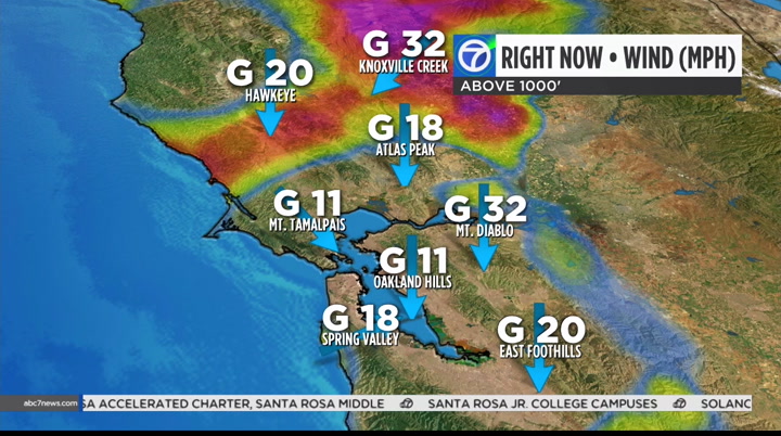
look at that, straight wind from mount diablo at 43 miles per hour. and oakland hills at about 25 miles per hour. knoxville creek, nearly 40 miles per hour. at the surface things seem more calm. direction is still out of the northeast. so throughout the next several hours, follow the colors. you can see the double digits here with the wind profile anywhere from 10 to 15 miles per hour. still breezy, but certainly not as windy. we're not gaining any moisture in our atmosphere. it's still bone dry. it continues to come down, out oth ds a to noit the red flag warning, perhaps gusts to near 50. here's a look at the smoke forecast. they're out of the northeast. that means they're pushing the smoke to the southeast mainly. when we have a straigh nth wind, you will g eas valleys. it will be variable. that's why we have our spare the air alert. look at tuesday. this is when the northeast winds kick up again. starting out cool in the 50s out there. for the rest of you today in the low 70s, some hazy sun out there. >> all right. looking at the bay bridge toll p
look at that, straight wind from mount diablo at 43 miles per hour. and oakland hills at about 25 miles per hour. knoxville creek, nearly 40 miles per hour. at the surface things seem more calm. direction is still out of the northeast. so throughout the next several hours, follow the colors. you can see the double digits here with the wind profile anywhere from 10 to 15 miles per hour. still breezy, but certainly not as windy. we're not gaining any moisture in our atmosphere. it's still bone...
116
116
Oct 10, 2019
10/19
by
KGO
tv
eye 116
favorite 0
quote 0
the winds right now are gusting to 32 in mount diablo. winds not only reaching parts of the bay area near the surface but it is dragging some bone dry air. look at the wind in santa rosa. it is 3%. it does not get much dryer than that. these winds are drying out the atmosphere as we speak. that combination not only the winds but the low humidity. relatively humidity continues unfortunately to lower over night tonight. first thing tomorrow morning, we are talking about humidity levels in the teens, across much of the bay area. you combine the humidity and the strengthening winds right now and the accomodaticombination ge fire danger. very high to extreme and that threat even continues by 4:00 a.m. and stretching only into the east bay hills. part of the range of a high fire danger. timeline of the forecast in a few minutes. >> drew, thank you so much. >> download our abc7 news app. keep track of our weather conditions. you can customize the app for the locations you are interested in. the app is also how we are sending out push alerts to t
the winds right now are gusting to 32 in mount diablo. winds not only reaching parts of the bay area near the surface but it is dragging some bone dry air. look at the wind in santa rosa. it is 3%. it does not get much dryer than that. these winds are drying out the atmosphere as we speak. that combination not only the winds but the low humidity. relatively humidity continues unfortunately to lower over night tonight. first thing tomorrow morning, we are talking about humidity levels in the...
89
89
Oct 10, 2019
10/19
by
KGO
tv
eye 89
favorite 0
quote 0
with you see we're high and very high initially around the diablo range. around noon you're at high. we'll continue to have high and extreme in the north bay until the afternoon hours when we start to drop down to just high. here's my accuweather seven-day forecast. 80s inland, mid 70s to near 80 around the bay. 70s at the coast. sue? >> let's look at our traffic maps. slow in all the usual spots. westbound 580 coming out of tracy. we have this accident southbound 880 in oakland, right lane remains blocked near hegenberger. sensors remain green there. i don't see any effect on b.a.r.t., caltrain or ace trains because of the >>> pg&e put barrierers arous as san francisco headquarters. the chp says someone shot towards a pg&e worker while that person was driving in a marked truck tuesday night north of sacramento. nobody got hurt. it's created this kind of womaonse. a whose husband worked for pg&e posted a photo online in support of the utility crews. at image has since gone viral. >> these people are human. they have nothing to do with the power outages or
with you see we're high and very high initially around the diablo range. around noon you're at high. we'll continue to have high and extreme in the north bay until the afternoon hours when we start to drop down to just high. here's my accuweather seven-day forecast. 80s inland, mid 70s to near 80 around the bay. 70s at the coast. sue? >> let's look at our traffic maps. slow in all the usual spots. westbound 580 coming out of tracy. we have this accident southbound 880 in oakland, right...
114
114
Oct 11, 2019
10/19
by
KPIX
tv
eye 114
favorite 0
quote 0
for the east bay there is the diablo range. we were talking about mount diablo. there is our 75. concorde the top gust was 25 speed. while that is certainly strong. nowhere near why we had such a concern in the mountains where the powerlines are. and all the dry brush and trees. more with coming up in a bit. the wind as far as the red flag warning that is over. more on the rest of the forecast in a few mi . >>ti nuor you can find it all on the areas impacted the outage on our unwe the largest of the three is in calimesa. flames have torn through a mobile home park destroying 10 homes. at last check the fire had grown to 500 acres. it is 0% contained. investigators say the fire started on a garbage truck dumped a load of trash that was on fire. >>> we are devastated. we arengpie together news. i have no idea. i can only pray it is. >>> back in the esbake oy ar in costa county and near sfo. evacuations and moraga. the other erupted under pg&e lines in brisbane. andrea is there for us now.>> reporter: those fires sparked underneath lines that were not re-energize. as part of this pu
for the east bay there is the diablo range. we were talking about mount diablo. there is our 75. concorde the top gust was 25 speed. while that is certainly strong. nowhere near why we had such a concern in the mountains where the powerlines are. and all the dry brush and trees. more with coming up in a bit. the wind as far as the red flag warning that is over. more on the rest of the forecast in a few mi . >>ti nuor you can find it all on the areas impacted the outage on our unwe the...
45
45
Oct 10, 2019
10/19
by
KPIX
tv
eye 45
favorite 0
quote 0
i want you to take a look at mount diablo with a 50 mile-per- hour wind. the winds pick up intensity when they have to get over those ridges . plus your higher elevation the winds will be stronger. that is why this red flag warning has been issued . it is for the mountains. the contra costa county and alameda county we are seeing wind gusts up to 30. it's not strong enough for a wind advisory. that is a low was grade advisory they would put out. were not even looking at that and neither is oakland. it does get breezy but the issue is the hills. look at the northbay at 5:00 a.m. 55 mile-per-hour sustained winds. for santa rosa, and we can go down into the south bay at 5:00 a.m. and if you look to santa clara county it is a bit breezy but those red bull's-eyes are showing up in the mountains. if we put the red flag warning on here that's why it's only in the mountains. it will expire at 5:00 p.m. on friday. let's get through sunrise tomorrow and then we technically have to get through 5:00 tomorrow afternoon. as far as the element that goes along with it, it
i want you to take a look at mount diablo with a 50 mile-per- hour wind. the winds pick up intensity when they have to get over those ridges . plus your higher elevation the winds will be stronger. that is why this red flag warning has been issued . it is for the mountains. the contra costa county and alameda county we are seeing wind gusts up to 30. it's not strong enough for a wind advisory. that is a low was grade advisory they would put out. were not even looking at that and neither is...
112
112
Oct 28, 2019
10/19
by
KGO
tv
eye 112
favorite 0
quote 0
you can see gusts around mount diablo, 42 miles per hour.heast, 21 miles per hour. we are looking at gusty upper elevation winds as the red flag warning continues through 11:00. elsewhe elsewhere, winds are calm, we have ay day in the north bay. throughout the morning hours, check out the direction. still out of the northeast. still a dry atmosphere. they begin to lighten up. that should help out a little bit. not getting a whole lot of moisture in the atmosphere in the next several days. it's 50 up by the fires. 15% humidity. wind gusts at about 10 miles per hour. our spare the air alert focuses on the smoke and poor air quality in the north bay.
you can see gusts around mount diablo, 42 miles per hour.heast, 21 miles per hour. we are looking at gusty upper elevation winds as the red flag warning continues through 11:00. elsewhe elsewhere, winds are calm, we have ay day in the north bay. throughout the morning hours, check out the direction. still out of the northeast. still a dry atmosphere. they begin to lighten up. that should help out a little bit. not getting a whole lot of moisture in the atmosphere in the next several days. it's...
54
54
Oct 10, 2019
10/19
by
KPIX
tv
eye 54
favorite 0
quote 0
look at mount diablo. in oakland a 15 mile-per-hour wind you might not notice. the same story in the northbay. look at the strong winds up in the mountains compared to santa rosa. the timeframe is 10:00 tonight and sunrise tomorrow and that is the worst of the winds in the mountains. >>> we want to go to pg&e headquarters where they are having an up date on their news conference. >> we envision going about 35 minutes. online it will include, we will have an update from our principal meteorologist. and we also have our senior vice president and we will get an update about the web. with that i will turn it over to get started. >> thank you, keith. thank you for joining us tonight. overall i want to reiterate a few points before i turn it over to provide an update in regards to the weather forecast. first, i'd like to reiterate that we understand the impact it has on our customers and our communities. this is not a decision we take lightly. and we think our customers and our communities for your patience. seconds, i would like to remind our customers and our commun
look at mount diablo. in oakland a 15 mile-per-hour wind you might not notice. the same story in the northbay. look at the strong winds up in the mountains compared to santa rosa. the timeframe is 10:00 tonight and sunrise tomorrow and that is the worst of the winds in the mountains. >>> we want to go to pg&e headquarters where they are having an up date on their news conference. >> we envision going about 35 minutes. online it will include, we will have an update from our...
88
88
Oct 17, 2019
10/19
by
KTVU
tv
eye 88
favorite 0
quote 0
mount diablo, .06. the wind will be picking up.re heading out later this afternoon i would bundle up. yesterday we had the feel of fall with cloud cover coming in. highs today in the 60s and 70s. dillon beach, ocean beach, 60s. menlo park and union city and campbell, upper 60s and low 70s. calistoga, danville and saratoga as well. the cloud cover has pushed off. there's not much to this front moving through. it is in the sierra nevada producing some light rain up there. the breeze out of the west, west and southwest. west, northwest and will pick up with dust between 25 and 30. some of that cool air is beginning to filter in. mid 50s on the pacifica peninsula. clearing in the morning and then breezy and windy with mostly sunny conditions but cool. 60s and 70s on the temperatures. the tracy commute is a mess. i heard you say that. >>> it is a mess and we also have the regular commutes that are beginning to fire up. for example at the bay bridge toll plaza you will see some slow traffic this morning. westbound which is typical. is no
mount diablo, .06. the wind will be picking up.re heading out later this afternoon i would bundle up. yesterday we had the feel of fall with cloud cover coming in. highs today in the 60s and 70s. dillon beach, ocean beach, 60s. menlo park and union city and campbell, upper 60s and low 70s. calistoga, danville and saratoga as well. the cloud cover has pushed off. there's not much to this front moving through. it is in the sierra nevada producing some light rain up there. the breeze out of the...
64
64
Oct 9, 2019
10/19
by
KPIX
tv
eye 64
favorite 0
quote 0
tomorrow, for the north and east bay hills and valley, the diablo range and santa cruz mountains. up in the higher elevations, up in the hills, guts up to 45 to 55 miles an hour. and with low relative humidity values is extreme. fire danger. so dangling us through the afternoon, the wind starts to pick up but i'll show you when future cast taking hour by hour. and when we'll see the peak wind gusts coming up. let's send it over to kpix 5 anne makovec live in san jose where pg&e has set up a center for those affect by the shutoffs. ann? >> reporter: yeah, if you don't have anywhere to go and you are waiting for the power to go out, this is the place to go. we are waiting for the power outaging happening in san jose. they have port-a-potties, several layers of security and security guards. let's go inside. let's not trip over my microphone cord and let's go inside and show you what we have. water, free water available. pg&e representatives here where you can ask them some questions and here, the almighty power cords that people are going to want to get their hands on. this is where
tomorrow, for the north and east bay hills and valley, the diablo range and santa cruz mountains. up in the higher elevations, up in the hills, guts up to 45 to 55 miles an hour. and with low relative humidity values is extreme. fire danger. so dangling us through the afternoon, the wind starts to pick up but i'll show you when future cast taking hour by hour. and when we'll see the peak wind gusts coming up. let's send it over to kpix 5 anne makovec live in san jose where pg&e has set up a...
62
62
Oct 23, 2019
10/19
by
KNTV
tv
eye 62
favorite 0
quote 0
diablo, bob redell, nbc bay area news. >>> and we could hear it in the microphone as well. and so nbcbayarea.com is your place for the outages and forecast. we have up to the minute details on the red flag warning. >> and tomorrow we'll start "today in the bay" early to get you prepared. we'll go on 30 minutes earlier starting at 4:00 a.m. if you live in a power shutoff zones, you still have time to download our nbc bay area app. this is a great way to keep in touch with what is going on, that way you could get up dates when we go on air. again that special edition of "today in the bay" tomorrow on thursday starting at 4:00 a.m. >>> and san jose is looking into taking over pg&e power infrastructure. the last round of blackouts left 60,000 customers in san jose without electricity. the city committee is set to vote on the issue today. if passed it will be sent to the full city council for consideration. the nearby city of santa clara have handled its own power for more than 120 years but pg&e has already said its facilities in san jose are not for sale. >>> in a developing s
diablo, bob redell, nbc bay area news. >>> and we could hear it in the microphone as well. and so nbcbayarea.com is your place for the outages and forecast. we have up to the minute details on the red flag warning. >> and tomorrow we'll start "today in the bay" early to get you prepared. we'll go on 30 minutes earlier starting at 4:00 a.m. if you live in a power shutoff zones, you still have time to download our nbc bay area app. this is a great way to keep in touch...
92
92
Oct 8, 2019
10/19
by
KPIX
tv
eye 92
favorite 0
quote 0
. >>> a live look towards mount diablo now. mary lee has a look at the live conditions. >> this could be the strongest wind event that we have seen so far this season with dry gusty offwinds. here is a look at the dublin cam. you will be under that red flag warning by tomorrow morning as well. red flag warning from 5:00 a.m. tomorrow until 5:00 p.m. thursday, for the north bay mountains, the east bay hills, north bay and east bay valleys. that's because of northerly to northeasterly winds, 20 to 30 miles an hour. gusts up to 45 to 55 miles an hour and that does mean an extreme fire danger, critical fire weather conditions, potentially dangerous fire weather conditions. wind advisory will be in effect from 6:00 a.m. wednesday until 3:00 p.m. on thursday to the north bay mountain, east bay hills and diablo range. could be some power outages and downed trees possible. future cast taking you hour by hour and when we expect to see the peak wind gusts coming up. kenny? >> thank you, mary. >>> two years ago today, strong winds and dry
. >>> a live look towards mount diablo now. mary lee has a look at the live conditions. >> this could be the strongest wind event that we have seen so far this season with dry gusty offwinds. here is a look at the dublin cam. you will be under that red flag warning by tomorrow morning as well. red flag warning from 5:00 a.m. tomorrow until 5:00 p.m. thursday, for the north bay mountains, the east bay hills, north bay and east bay valleys. that's because of northerly to...
56
56
Oct 30, 2019
10/19
by
KRON
tv
eye 56
favorite 0
quote 0
in the central valley and the sierra nevada, the east bay across the east bay mountains also the diablo range gointo see some very strong sty winds, maybe to 50 miles per hour over the east bay tonight and then aong the coastal range is still could see some very strong gusty winds cours no fires there but boy we get things going tonight we're going to see some very dangerous conditions throughout the night tonight and to early tomorrow morning. here's the very latest on the forecast for some of those wind you see that red beginning to show up even some purple as we head in toward 8 o'clock those winds blowing 2030 miles per hour and that is in the urban areas, 4mile an hour gusts, likely by 08:00pm across the mountain tops and then over as we head toward the next few midnight, we're talking about some of tho winds gusting near 40 miles per hour in the urban areas that is very very dangerous tonight and into early tomorrow morning, those windse'll continue to howl throughout the night tonight and then it looks like they'll b gin to calm down a little bit overnight into the earl morning h
in the central valley and the sierra nevada, the east bay across the east bay mountains also the diablo range gointo see some very strong sty winds, maybe to 50 miles per hour over the east bay tonight and then aong the coastal range is still could see some very strong gusty winds cours no fires there but boy we get things going tonight we're going to see some very dangerous conditions throughout the night tonight and to early tomorrow morning. here's the very latest on the forecast for some of...
69
69
Oct 23, 2019
10/19
by
KNTV
tv
eye 69
favorite 0
quote 0
this is the diablo wind. it's the reverse of the cooler ocean breeze. what happens is dry air travels from inland california. moves over our mountains including mountain diablo where the name comes from and then pushes down in to the valleys. now the important weather process that happens, when you get dry air moving down the mountains. the air molecules get compressed. you get friction that is created, temperatures warm up and the air dries o and that is what makes a diablo wind so dangerous. >>> and that's what we are going to see as we hit wednesday night in to thursday. you see, wednesday night, winds 20-30 in the north bay. that's the number one risk here. we will probably have calm winds in san jose is the same time and the mountain gusts could be up to 50 miles an hour. wednesday night in to thursday morning. you can see it here and then as we move through thursday afternoon, we will see the wind calm down. so the extended forecast has us up to 87 in san francisco by thursday. we are down to a cooler 69 on sunday. and 60s to start next week. inla
this is the diablo wind. it's the reverse of the cooler ocean breeze. what happens is dry air travels from inland california. moves over our mountains including mountain diablo where the name comes from and then pushes down in to the valleys. now the important weather process that happens, when you get dry air moving down the mountains. the air molecules get compressed. you get friction that is created, temperatures warm up and the air dries o and that is what makes a diablo wind so dangerous....
112
112
Oct 10, 2019
10/19
by
KNTV
tv
eye 112
favorite 0
quote 0
diablo 59. that's where the real threat is in the higher elevations.omorrow morning, focus is the north and east bay. wind gusts 20 to 40. really not nearly as much for the south bay. i want you to notice that contrast in the forecast. we do clear out from the wind once we hit tomorrow afternoon so hopefully no wildfires, and we get this power turned back on soon. i know it's making a lot of folks anxious. good news in the forecast, we could get showers, possibly by next thursday and friday. that's a ways out there, but looking ahead toward it. >> that's great news. our morning crew is already in the newsroom now getting ready for an early start. 4:00 a.m. with laura, marcus, kerry and mike. thanks for joining us at 11:00. >> bye-bye. [ cheers and applause ♪ >> steve: from studio 6b in rockefeller center in the heart of new york city, it's "the tonight show starring jimmy fallon."
diablo 59. that's where the real threat is in the higher elevations.omorrow morning, focus is the north and east bay. wind gusts 20 to 40. really not nearly as much for the south bay. i want you to notice that contrast in the forecast. we do clear out from the wind once we hit tomorrow afternoon so hopefully no wildfires, and we get this power turned back on soon. i know it's making a lot of folks anxious. good news in the forecast, we could get showers, possibly by next thursday and friday....
48
48
Oct 30, 2019
10/19
by
KGO
tv
eye 48
favorite 0
quote 0
still around 42 in helena. 70 overnight. 38 in diablo, we were 55 overnight.east bay hills, about 38 miles per hour. the winds are still out there. it may just not be breezy where you live. we didn't expect it to be a repeat of over the weekend. not in the lower elevations. worried about smoke mainly in the north bay today peaking around 4:00 this afternoon. pretty clean air during the overnight hours. we'll peak again tomorrow but not quite as thick. tomorrow, halloween is looking all treats with sunshine turning to stars. 60s turning to 50s. ho hope it's a good one for you. >> i enjoyed that dancing mummy graphic. we are looking at aiful situation on the richmond-san rafael bridge. nice and clear over there. and, yeah, walnut creek not too bad. starting to fill in on 680. this is a live look for anyone about to head that way. also going back to the north bay so i can remind everyone that state route 128 between geyserville and calistoga is closed because of the kincade fire. it will remain that way until further notice. make sure to use your alternates this
still around 42 in helena. 70 overnight. 38 in diablo, we were 55 overnight.east bay hills, about 38 miles per hour. the winds are still out there. it may just not be breezy where you live. we didn't expect it to be a repeat of over the weekend. not in the lower elevations. worried about smoke mainly in the north bay today peaking around 4:00 this afternoon. pretty clean air during the overnight hours. we'll peak again tomorrow but not quite as thick. tomorrow, halloween is looking all treats...
56
56
Oct 11, 2019
10/19
by
KPIX
tv
eye 56
favorite 0
quote 0
mount diablo state park closed until further notice. after registering 70+ mile per hour gusts at the peak. winasg ta hatso calm. it depends on where you live. >>> that was the message we were all doing our best last night to get across. it wasn't going to be bad whereo u vey sts onwamount diablo. ba mile-per-hour in the reh rtao 5 pm. we are starting to leave that behind. dry air is still here. let me show you one thing that stands out about today. those other current relative humidity readings. 9% for san francisco. 6% santa rosa. a little perspective. typical would be in the 50s. this is very dry find yourseapstick for the stndiz. ayleoit me show you how this wi play out. e deeper the shade of brown the dryer the air. all the way through friday. notice how it comes back and forth a little bit. we never get a strong onshore flow back. we never start pulling in. some of that air with higher levels of moisture until we get to sunday morning. by the time we get there the streamlines are coming back on shore. look where the humidity level
mount diablo state park closed until further notice. after registering 70+ mile per hour gusts at the peak. winasg ta hatso calm. it depends on where you live. >>> that was the message we were all doing our best last night to get across. it wasn't going to be bad whereo u vey sts onwamount diablo. ba mile-per-hour in the reh rtao 5 pm. we are starting to leave that behind. dry air is still here. let me show you one thing that stands out about today. those other current relative...
113
113
Oct 11, 2019
10/19
by
KPIX
tv
eye 113
favorite 0
quote 0
mount diablo 75. everybody else and a lot of the major communities sfo or oakland. it got windy. 25 miles per hour gusts is not enough for a wind advisory. this just enough you will notice it was windy if you were out in the morning or afternoon. let's put perspective on this. we go back to when we hit our peak gusts early morning. the brunt of the colors clearly outline all of the mountain ranges. we are not registering much in the lower elevations. as far as the mount st. helena reading at 77. just on the northern edge of napa valley. silverado trail and work your way to the head of the valley. that is where we hit the strongest wind. 16 mile per hour gusts in petaluma. that is the strongest it got. this whole event. that is right in line with the way it looked like this was going to play out. the same thing for the east bay hills. diablo range here of the east bay hills. that is where you pick up the right colors. we don't see much at all for the rest of the area where we live. there is mount diablo with 75 mile per hour gusts. we did notice a st of gu 25morn hou
mount diablo 75. everybody else and a lot of the major communities sfo or oakland. it got windy. 25 miles per hour gusts is not enough for a wind advisory. this just enough you will notice it was windy if you were out in the morning or afternoon. let's put perspective on this. we go back to when we hit our peak gusts early morning. the brunt of the colors clearly outline all of the mountain ranges. we are not registering much in the lower elevations. as far as the mount st. helena reading at...
103
103
Oct 15, 2019
10/19
by
KNTV
tv
eye 103
favorite 0
quote 0
strong shaking near mount diablo. we might find some furniture moved, even plaster in the walls might have cracks in it, which goes along with moderate to light shaking. you can see the aftershocks. we have primarily seen have been at a 2.0 and lower over the past hour. but you can see how active it continues to remain right here around pleasant hill. so certainly a swarm of activity tonight. we're going to continue to track this. i just do want to reiterate that while this was a 4.5, there is the chance this could be a foreshock to a larger earthquake. i don't want to alarm anyone, but just remember, drop, cover and hold. and if we do have a larger earthquake that happens, do not run out of a building. that is one of the number one ways that people do get killed during earthquakes. so it's a great thing to think about your flashlights, your radio, everything you need to it's dark outside. if we got a big earthquake, it would be hard to hurry up and get all that stuff you need. so think about that right now. be safe.
strong shaking near mount diablo. we might find some furniture moved, even plaster in the walls might have cracks in it, which goes along with moderate to light shaking. you can see the aftershocks. we have primarily seen have been at a 2.0 and lower over the past hour. but you can see how active it continues to remain right here around pleasant hill. so certainly a swarm of activity tonight. we're going to continue to track this. i just do want to reiterate that while this was a 4.5, there is...
162
162
Oct 27, 2019
10/19
by
KGO
tv
eye 162
favorite 0
quote 0
diablo could be gusting near 60 miles an hour, from 40 to 60 miles per hour.the day, the relative humidity these numbers will continue to drop adding to the dry atmosphere. our high fire danger, red flag warning until 11:00 tomorrow with the gusts 35 to 60 miles an hour. you can see just inside the bay here, we're not looking at those extreme conditions but the high wind warning for where everyone lives where we're looking at winds from 30 to 40 miles an hour. check on the winds here and guys, 59 degrees it's cool but the humidity 10%, east wind at 15, gusting to near 30 miles an hour. so today we're in the 70s. it's hazy. it is breezy. and the winds will be up as you go up in height from 500, to 600 feet. talking very gusty winds. the accuweather seven-day forecast, high fire danger today, continues to be gusty tomorrow morning and then we'll see the winds lighten up. the temperatures stay rather seasonal 60s and 70s but by tuesday night into wednesday, we could see another much smaller offshore wind event. we have to get through this one first, obviously. >>
diablo could be gusting near 60 miles an hour, from 40 to 60 miles per hour.the day, the relative humidity these numbers will continue to drop adding to the dry atmosphere. our high fire danger, red flag warning until 11:00 tomorrow with the gusts 35 to 60 miles an hour. you can see just inside the bay here, we're not looking at those extreme conditions but the high wind warning for where everyone lives where we're looking at winds from 30 to 40 miles an hour. check on the winds here and guys,...
106
106
Oct 14, 2019
10/19
by
KNTV
tv
eye 106
favorite 0
quote 0
diablo superintendent that reads in part, the primary goals of the district are to reach a settlement agreement through the mediation process that sustained the district's ability to provide services to students and meet their needs and appropriate compensate district employees and stay in positive financial coherence per the parameter provided by the state. the superintendent added they have handed over data and information to the bargaining team but the union said they haven't gotten the information they need to bargain in fair -- >> so they're steel debating over who has what? >> they are still arguing. the district gave up what they are supposed to and the union said otherwise so that is part of the negotiation. >> they have to clear that up too. thanks, kris. >>> pictures in of a fire in alameda county that broke out at about 11:00 last night about six mile news cul canyon. they did not spread to nearby vegetation. nobody was hurt. crews are looking into what caused the fire. >>> a live look at a camera over san francisco. definitely jacket weather out there this morning. >> but
diablo superintendent that reads in part, the primary goals of the district are to reach a settlement agreement through the mediation process that sustained the district's ability to provide services to students and meet their needs and appropriate compensate district employees and stay in positive financial coherence per the parameter provided by the state. the superintendent added they have handed over data and information to the bargaining team but the union said they haven't gotten the...
109
109
Oct 10, 2019
10/19
by
KTVU
tv
eye 109
favorite 0
quote 0
mount diablo had a gust of 75 miles per hour. that is over almost 4000 feet.the winds were at 52 miles per hour. that is over 1400 feet. a wind gust at 23 miles an hour. the wind range hear from sea level all the way to the higher elevations. the higher peaks of the bay area. we have this northerly flow in place keeping us on the dry side. you probably already noticed that with relative humidity. single digit, santa rosa, fairfield and concord. we have the wind and if a fire were to start it could spread rapidly. that has been the key concern all week long. at the surface a bit of a break. san jose eight miles an hour. it is a warm day. lots of 70s and around 80 deees around fairfield and san jose in the upper 70s. here's a live camera looking out to the golden gate bridge with fog free conditions. it is hard for a fog bank to form with dry conditions. the red flag warning goes away at 5 pm. decreasing winds this evening but elevated fire danger as we head into tomorrow and basically all month long until we get the soaking rains we are waiting for. that is not
mount diablo had a gust of 75 miles per hour. that is over almost 4000 feet.the winds were at 52 miles per hour. that is over 1400 feet. a wind gust at 23 miles an hour. the wind range hear from sea level all the way to the higher elevations. the higher peaks of the bay area. we have this northerly flow in place keeping us on the dry side. you probably already noticed that with relative humidity. single digit, santa rosa, fairfield and concord. we have the wind and if a fire were to start it...
87
87
Oct 10, 2019
10/19
by
KGO
tv
eye 87
favorite 0
quote 0
. >> reporter: well, ama, dan, we're here on mount diablo boulevard. i've been looking over my shoulder all night to wait and see if those whole foods lights go out. they could go out any minute since pg&e told us about 20 minutes ago they had begun those phase two shutoffs in the east bay. we know they've egun in alameda county and could start any minute here in contra costa. rushing to take advantage of last-minute electrical luxuries in the east bay wednesday night. at whole foods in lafayette, workers stayed late to transfer refrigerated inventory to freezer trucks in their parking lot. every light bulb a glowing reminder. >> we stopped taking reservations because of the ma ba backed up with portable generators. >> we sourced as many flashlights and glow sticks as we possibly could. >> reporter: a guest visiting from a caribbean island is impressed that at least californians know dangerous fire weather is behind the planned outage. >> i'm really glad we at least know what the reason is because every once in a while a planned power outage will take
. >> reporter: well, ama, dan, we're here on mount diablo boulevard. i've been looking over my shoulder all night to wait and see if those whole foods lights go out. they could go out any minute since pg&e told us about 20 minutes ago they had begun those phase two shutoffs in the east bay. we know they've egun in alameda county and could start any minute here in contra costa. rushing to take advantage of last-minute electrical luxuries in the east bay wednesday night. at whole foods...
92
92
Oct 10, 2019
10/19
by
KTVU
tv
eye 92
favorite 0
quote 0
>> mount diablo had gusts up to 63. everybody. if you don't have a breeze it's probably cold at your location but if you do you can get that gus 40-50 miles per hour . i realize this is one of those darned if you do and don't if you don't but the advisor still continues in the north east bay hills and that will continue until 3:00 today. that covers areas in and around with a fire is. that's why they post those advisories. it wasn't the wind yesterday, it was the humidity, which by the way went to 3%. 3% humidity. usually i get a moraga temp but something isn't happening. 60s on the thames. there is a good breeze coming off black diamond. dollar ridge, 40 miles per hour . above the oakland zoo, 44. above the caldecott. 41 miles per hour . it is very dry and in the hills it's windy. fairfield and vacaville, you don't have to go far to find no wind at all or a good breeze. vacaville have gusts at 40. some locations had nothing at all. the system or march east. as it does through the day the pressure gradients were relax but for the
>> mount diablo had gusts up to 63. everybody. if you don't have a breeze it's probably cold at your location but if you do you can get that gus 40-50 miles per hour . i realize this is one of those darned if you do and don't if you don't but the advisor still continues in the north east bay hills and that will continue until 3:00 today. that covers areas in and around with a fire is. that's why they post those advisories. it wasn't the wind yesterday, it was the humidity, which by the...
107
107
Oct 27, 2019
10/19
by
KGO
tv
eye 107
favorite 0
quote 0
diablo near 50-mile-an-hour wind gusts.m, over 30 mile an hour and the east foothills. the northeasterly winds blowing hard, blowing to the south and really that is unbelievable how big the fire and those embers will jump out ahead blowing all the way to bodega bay and the ocean. gusts 36 santa rosa. you can see oakland and san jose up to 26 miles an hour. here's a look at the smoke folk throughout t -- forecast throughout the day. with the gusty wind see at times it will be smoky and hazy and we will have some breaks because the winds are quite erratic out there and they remain gusty. our red flag warning through 11:00 tomorrow as well as our high wind warning in the upper elevations and the wind advisory for the bay area in general throughout the day today. if you're not seeing the wind right now it will be increasing throughout the day. kristen and kate. >> thank you. >>> now let's get to the details on the major stories we're following this morning. the kincade fire and a mass pg&e power shutoff. >> cal fire announced t
diablo near 50-mile-an-hour wind gusts.m, over 30 mile an hour and the east foothills. the northeasterly winds blowing hard, blowing to the south and really that is unbelievable how big the fire and those embers will jump out ahead blowing all the way to bodega bay and the ocean. gusts 36 santa rosa. you can see oakland and san jose up to 26 miles an hour. here's a look at the smoke folk throughout t -- forecast throughout the day. with the gusty wind see at times it will be smoky and hazy and...
33
33
Oct 10, 2019
10/19
by
KRON
tv
eye 33
favorite 0
quote 0
and you can see that the diablo range up into the oakland hills mount diablo on up into marine had winds mountains and then much of the north bay affected by wind advisories even into the afternoon today. so this affects areas right around the merrill fire as well as other areas too. and as robin you talk to me as well we have the red flag warnings that are still in effect we have humidity levels in the single digits now this is bone dry conditions right here as we make our way into the afternoon winds will continue to be a thing as you can see we still have those wind advisories until 03:00pm today. you factor in the low humidity that is specially gets bit lower on into our afternoon hours and the hour still going to be talking about likely power outages through much of the day today we're going to be talking about cruz keeping a very close eye on these areas affected by both red flag warnings and wind advisories through the day and of course those containment lines right around the merrill fire going to be kept a close eye on as we do make our way on into the afternoon a extreme fire d
and you can see that the diablo range up into the oakland hills mount diablo on up into marine had winds mountains and then much of the north bay affected by wind advisories even into the afternoon today. so this affects areas right around the merrill fire as well as other areas too. and as robin you talk to me as well we have the red flag warnings that are still in effect we have humidity levels in the single digits now this is bone dry conditions right here as we make our way into the...
79
79
Oct 30, 2019
10/19
by
KTVU
tv
eye 79
favorite 0
quote 0
mount diablo, do not the 36. the offshored direction is making for warm temperatures from ocean beach and montero to santa cruz. all at 59. 15 miles per hour to the north gusting at 23 and travis. east twin in oakland. east, southeast at the napa airport. santa rosa, and novato, not bad. fairfield, concor, oakland and hayward all in the teens including livermore. sfo at 29%. you can see that easterly breeze coming even though the wind is not that strong at the surface the humidity is low which is whether fire danger remains a high. 33 in santa rosa get 55 in albany. that's the offshored direction. montero between 57 and 59. one observation in santa cruz is at 52. i saw another one at 59. 34 in morgan hill. one observation in gilroy with the breeze at 46 and 40 in san jose. 50 in cupertino. you can see the breeze versus no breeze at all. water temperatures are lost in all of this because they're not as important this time of year but are still very cold. 52-54 for most. point rate at 53. out to sea she goes becaus
mount diablo, do not the 36. the offshored direction is making for warm temperatures from ocean beach and montero to santa cruz. all at 59. 15 miles per hour to the north gusting at 23 and travis. east twin in oakland. east, southeast at the napa airport. santa rosa, and novato, not bad. fairfield, concor, oakland and hayward all in the teens including livermore. sfo at 29%. you can see that easterly breeze coming even though the wind is not that strong at the surface the humidity is low which...
110
110
Oct 10, 2019
10/19
by
KTVU
tv
eye 110
favorite 0
quote 0
wind gusts, 75 at mount diablo. mount st. helena, 77. 36-60. mt. umunhum, in the santa cruz mountains including the national weather service radar site is there, 60 miles per hour . everything is driving offshore, eastern northeast. out to the i-84, napa airport is not been reporting data since midnight. if you were at the napa airport and you say i'm not getting information, that's probably why. they are not reporting. i hope they get that fixed. travis, vacaville and davis, 30- 40 miles per hour out of the north and also in the oakland hills above the caldecott, northeast park the same above the oakland zoo. black diamond, 23. at atlas p, 30. humidity in the teens . the wind advisory in the north and east bay hills will go until 3:00. red flag warning foremost until 5:00. relative humidity yesterday without much of a breeze in santa rosa 03%. dew points were amazingly low. even without the breeze, very critical fire conditions. look at that deep system sweeping across. denver at 22 and looking for record lows in the teens and look at the division
wind gusts, 75 at mount diablo. mount st. helena, 77. 36-60. mt. umunhum, in the santa cruz mountains including the national weather service radar site is there, 60 miles per hour . everything is driving offshore, eastern northeast. out to the i-84, napa airport is not been reporting data since midnight. if you were at the napa airport and you say i'm not getting information, that's probably why. they are not reporting. i hope they get that fixed. travis, vacaville and davis, 30- 40 miles per...
61
61
Oct 15, 2019
10/19
by
KRON
tv
eye 61
favorite 0
quote 0
that runs up the try valleys and you have the concord green valley fault, which extends from mount diablo north. so this cluster of earthquakes are happened right in between a as we zoom in you'll see that we're looking at a whole slew of them. the majority of them happening on the west side of 6 80's you can see here right o was the largest one that was the 4.5 and all these other sort of popkin afterwards in the minutes in hours that followed but where was it felt that's the better question right when it comes to how far out the shaking goes and that's what this map is for its the did you feel it map that the usgs provides and is based on people letting them know what the 5th shaking felt like and where they're located you can see people's far south the santa cruz felt far north as sacramento and roseville we had people even as far east as stockton modesto turlock said even all the way out into the sierra foothills, so it was pretty impressive to see how far white out it was felt but as to how strong it was well you got to ask different people you can get different stories, especially a
that runs up the try valleys and you have the concord green valley fault, which extends from mount diablo north. so this cluster of earthquakes are happened right in between a as we zoom in you'll see that we're looking at a whole slew of them. the majority of them happening on the west side of 6 80's you can see here right o was the largest one that was the 4.5 and all these other sort of popkin afterwards in the minutes in hours that followed but where was it felt that's the better question...
97
97
Oct 24, 2019
10/19
by
KNTV
tv
eye 97
favorite 0
quote 0
diablo. tonight, notice how this wind will build in first around the north bay with gusts that could hit 5 miles per hou0 miles per >>> well, even if your power is going to stay on like contra costa county, the fire danger is still high. were in a red flag warning right now in most of the bay area. nbc bay area's marianne favro is live in concord with a look at a new strategy firefighters are using to respond more quickly to fires. >> reporter: janelle, about an hour ago this entire parking lot was filled with fire engines from several different agencies here in contra costa county. collectively they're known as task force 2025, and they just took off to go back to their respective stations. now, for at least the next 24 hours, the task force firefighters, engines, water tender trucks, and bulldozer will be strategically placed and available to respond to a fire at a moment's notice across contra costa county. this pre-positioning strategy paid off earlier this month when a fire threatened ho
diablo. tonight, notice how this wind will build in first around the north bay with gusts that could hit 5 miles per hou0 miles per >>> well, even if your power is going to stay on like contra costa county, the fire danger is still high. were in a red flag warning right now in most of the bay area. nbc bay area's marianne favro is live in concord with a look at a new strategy firefighters are using to respond more quickly to fires. >> reporter: janelle, about an hour ago this...
43
43
Oct 30, 2019
10/19
by
KTVU
tv
eye 43
favorite 0
quote 0
mount diablo, 40. these are current gusts. not much in the santa cruz mountains but one of the caldecott and the oakland hills, that is 30 miles per hour . i did see around los vaqueros reservoir 28. half moon bay, 22-35 and in the marin county hills you see 20- 25. oakland, north at 30. oakland south is above the oakland zoo, 27. mount diablo, 40. there are some good gusts for a few. mostly confined to higher elevations. you can see the officer direction which is funneling itself toward parts of the san mateo coast and higher elevations as well. 30s, 40s and 50s on the temperatures. the breeze is holding temperatures up. if not, it's pretty cold. there's a good gust as well in the direction that is offshore. were not done with that yet. low humidity. higher elevations at the surface. not as bad but you can see there's an easterly or northerly component still in place. that's where the red flag warning continues. everything is driven out to sea. it will be quieter this afternoon and this evening. things will calm down. 60s and
mount diablo, 40. these are current gusts. not much in the santa cruz mountains but one of the caldecott and the oakland hills, that is 30 miles per hour . i did see around los vaqueros reservoir 28. half moon bay, 22-35 and in the marin county hills you see 20- 25. oakland, north at 30. oakland south is above the oakland zoo, 27. mount diablo, 40. there are some good gusts for a few. mostly confined to higher elevations. you can see the officer direction which is funneling itself toward parts...
76
76
Oct 8, 2019
10/19
by
KPIX
tv
eye 76
favorite 0
quote 0
the santa cruz send it diablo range. gusts 35-55 miles an hour.ially dangerous fire weather conditions. a wind advisory in effect until thursday afternoon for the north bay down to east bay hills and the diablo range. we could see power outages and downed trees possible. here is the satellite and radar view. the low-pressure system will drop a dry cold front our way and we will see the stronger onshore flow and that's why the temperatures will be cooler. behind the front the wind will kick up and we are tracking strong offshore winds heading through late tonight, wednesday and thursday. today with the drive front looking at high-level clouds today, temperatures cooler wednesday and we will see strong wind. you can see the wind picking up tonight. we will see the peak wind gusts wednesday morning through thursday. for today looking at temperatures cooler compared to yesterday. still above average. taking you to the south bay, 83 for the high. 84 in san jose 87 four morgan hill. daytime highs topping out at 84 in concord after hitting a high in the
the santa cruz send it diablo range. gusts 35-55 miles an hour.ially dangerous fire weather conditions. a wind advisory in effect until thursday afternoon for the north bay down to east bay hills and the diablo range. we could see power outages and downed trees possible. here is the satellite and radar view. the low-pressure system will drop a dry cold front our way and we will see the stronger onshore flow and that's why the temperatures will be cooler. behind the front the wind will kick up...
85
85
Oct 10, 2019
10/19
by
KTVU
tv
eye 85
favorite 0
quote 0
mount diablo, gusting to 75 miles-an-hour at 3:20 in the morning. mount st.at 77. wind speeds in lafayette, 46 miles. not far away, blacklock, 59. there are some that are cool, including albini at 48. the wind speed is easterly or northeasterly. santa rosa has a north wind, nevada, south. it is turning a little bit and will eventually get so far into the plains that the pressure gradient will relax. 29 in olema valley and 60s in vacaville. otherwise, sunny and 70s and 80s on the highs. >>> steve, there are crowded conditions on bay area roadways and just like it would be on a normal day, the power outages aren't affecting the freeways but they are affecting local roads where stoplights may be out at major intersections. treat those as 4-way stops and that will add time to your commute. this is near the oakland airport in front of the coliseum and it slows from san leandro to downtown oakland with southbound 880 slowing from hayward to fremont and south on 680 is recovering from problems. the south bay commute has been slow getting to the west valley. let's go
mount diablo, gusting to 75 miles-an-hour at 3:20 in the morning. mount st.at 77. wind speeds in lafayette, 46 miles. not far away, blacklock, 59. there are some that are cool, including albini at 48. the wind speed is easterly or northeasterly. santa rosa has a north wind, nevada, south. it is turning a little bit and will eventually get so far into the plains that the pressure gradient will relax. 29 in olema valley and 60s in vacaville. otherwise, sunny and 70s and 80s on the highs....
118
118
Oct 27, 2019
10/19
by
KGO
tv
eye 118
favorite 0
quote 0
the diablo range has been at 50 miles an hour. still looking at the gusty north northwest winds from 30 to 5:00. winds at sunset will back off a little bit. stronger winds come in at sunrise. we are not out of this for another 24 hours and as we look at the dew points, 13 degree dew point in napa. that is just bone dry. oakland. now your winds are picking up as well in high ward and the peninsula. there is pretty much no moisture or very little moisture in the atmosphere. livermore down to 19%. 24% in hayward. look at san jose, 21%. it is 9:00 in the morning and we are at very, going into the single digit rains, the winds continue to gust and it's actually not bad in the bay area. the winds are so gusty they are starting to blouw and we will have some haze. there is an air quality advisory throughout the bay area. the blue indicates very little in the way of smoke. you'll notice most of it is up to the north near cloverdale, healdsburg where the fires are burning. some of the spot fires will continue as well perhaps into the east
the diablo range has been at 50 miles an hour. still looking at the gusty north northwest winds from 30 to 5:00. winds at sunset will back off a little bit. stronger winds come in at sunrise. we are not out of this for another 24 hours and as we look at the dew points, 13 degree dew point in napa. that is just bone dry. oakland. now your winds are picking up as well in high ward and the peninsula. there is pretty much no moisture or very little moisture in the atmosphere. livermore down to 19%....
105
105
tv
eye 105
favorite 0
quote 0
that's on diablo. 3,800 feet. above 1,000 feet, we're as low as 6 miles per hour in the oakland hills. so the event is not here yet. the humidity levels, while getting drier in the north bay, below 30%. everybody else is above that heading deeper into the bay area. our surface winds wither we live, about 12 to 14. again, manageable. that 12 is in novato, that 14 is at sfo. our 450u7humidity levels are no. we're just barely getting into this system. so we have a long way to go. another 35, 36 hours until this is over let's talk about your commute. four-way stops, if you come to an area without power. check first. i have not heard about mass transit, but you never know. it will be windy north of the bay bridge, 9:00 this evening to 9:00 tomorrow morning. that's when it will be most dangerous to be out on the water. when we come back, we'll look at some other areas of california that are under a higher fire danger and i'll pinpoint where and what time i think the highest fire dangers will hit our bay area neighborhoo
that's on diablo. 3,800 feet. above 1,000 feet, we're as low as 6 miles per hour in the oakland hills. so the event is not here yet. the humidity levels, while getting drier in the north bay, below 30%. everybody else is above that heading deeper into the bay area. our surface winds wither we live, about 12 to 14. again, manageable. that 12 is in novato, that 14 is at sfo. our 450u7humidity levels are no. we're just barely getting into this system. so we have a long way to go. another 35, 36...
273
273
Oct 10, 2019
10/19
by
KGO
tv
eye 273
favorite 0
quote 0
diablo. fastest in the next couple of hours and hang on to 5:00 and noon in the santa cruz mountains and this is why we have the high fire danger continuing. sue. >> earlier problem in walnut creek, and the accident at north main is cleared. and slow and go in concord to the 24 interchange, and very slow over the sunol grade, and earlier accident clearing out of the westbound 580 near castro street. >>> and now, diane sawyer is talking to julie andrews about her career and much more. we will have another update in 30 minutes, but you can find more news and >>> good morning, america. it's 8:00 a.m. state of emergency. massive power outages out west. hundreds of thousands in the dark in northern california. as fierce winds kick up new fears of wildfires. >>> also this morning, crisis in syria. turkey launching an assault against our allies there striking dozens of targets against the kurds. president trump now trying to distance himself from the operation just days after green lighting it. ♪ >>
diablo. fastest in the next couple of hours and hang on to 5:00 and noon in the santa cruz mountains and this is why we have the high fire danger continuing. sue. >> earlier problem in walnut creek, and the accident at north main is cleared. and slow and go in concord to the 24 interchange, and very slow over the sunol grade, and earlier accident clearing out of the westbound 580 near castro street. >>> and now, diane sawyer is talking to julie andrews about her career and much...
109
109
Oct 10, 2019
10/19
by
KPIX
tv
eye 109
favorite 0
quote 0
mount diablo clocking wind gusts up to 75 miles-per-hour. low roll activity humidity values in the single digit to teens. and energy release component, 97% measures how dries the fuels and vegetation are right now. that means that energy release is explosive if a fire does happen. >>> we've got a line of cars as you work your way along the any mets free wow. ed oua you coup the right lanes. r spectators and activity off to the right side. a bit of a backup past the coliseum. still early a lot better on 880. >>> warriors head coach steve kur is city center of the latest attack after kerr said no comment when asked about houston rockets gm support for antigovernment protesters in hong kong. >> i watched this guy who was like a little boy to be scared to be answering the question. he couldn't answer the question, he was shaking, i don't know, i don't know. he didn't know how to answer the question and yet talk about the united states very badly. >> the president apparently mocking the coach calling him a little boy. he openly feuded with member
mount diablo clocking wind gusts up to 75 miles-per-hour. low roll activity humidity values in the single digit to teens. and energy release component, 97% measures how dries the fuels and vegetation are right now. that means that energy release is explosive if a fire does happen. >>> we've got a line of cars as you work your way along the any mets free wow. ed oua you coup the right lanes. r spectators and activity off to the right side. a bit of a backup past the coliseum. still...
144
144
Oct 10, 2019
10/19
by
KTVU
tv
eye 144
favorite 0
quote 0
meteorology continue to track it has been tracking over the last week what we call a diablo wind storm. we are going to have a weather system that is an inside slider, a classic set up for what we know as diablo wind across northern california. as the system moves south thursday into friday, it will produce santa ana winds across southern california, including portions of our tore tory, the mountains. this is a california wide fire weather of it. meteorology continues to track the first phase occur today. we had north winds going, sacramento valley as well as some of our adjacent train on either side of the valley. we saw portions of reading had guessed the 50 miles per hour. one thing i just wanted to go back and say about the diablo in santana wind events, these events historically are the events that caused the most destructive wildfires in california history. we are seeing some of the same conditions that are going to develop then we have seen in previous offshore diablo and santa ana wind events. it is a brick area situation. meteorology continues to court nate with their agency p
meteorology continue to track it has been tracking over the last week what we call a diablo wind storm. we are going to have a weather system that is an inside slider, a classic set up for what we know as diablo wind across northern california. as the system moves south thursday into friday, it will produce santa ana winds across southern california, including portions of our tore tory, the mountains. this is a california wide fire weather of it. meteorology continues to track the first phase...
94
94
Oct 9, 2019
10/19
by
KPIX
tv
eye 94
favorite 0
quote 0
to the north and east and diablo and santa cruz mountains with the northerly winds up to 15 and gusts 45 to 55 miles per hour and that's why we are talking about the extreme fire danger. a wind advisory for the north and east bay hills above 1000 feet and the diablo range could see power outages with these strong winds there. so here is the satellite and radar view. this is all because of the low pressure system that is going to drop into the great basin and that is why the winds will kick up with those offshore wind. we will time it out for futurecast taking you through the day. in the afternoon we will see breezy conditions but it gets going for us for tonight and tomorrow morning. those red and purple color indicating wind gusts 30 to 50 miles per hour. and really you will notice stop thursday in the morning at 9:00 a.m. you can really see fairfield 48 miles per hour wind29 as well a- moon bay and the winds relax for thursday in the afternoon. for today. looking at highs much cooler. 78 in concord and 73 in fremont and 76 in oakland and upper 60s for san francisco. here is the exte
to the north and east and diablo and santa cruz mountains with the northerly winds up to 15 and gusts 45 to 55 miles per hour and that's why we are talking about the extreme fire danger. a wind advisory for the north and east bay hills above 1000 feet and the diablo range could see power outages with these strong winds there. so here is the satellite and radar view. this is all because of the low pressure system that is going to drop into the great basin and that is why the winds will kick up...
76
76
Oct 30, 2019
10/19
by
KRON
tv
eye 76
favorite 0
quote 0
that's a mile healdsburg hills 50 miles per hour mount diablo oakland hills to the north there at44 miles per hour near san jose you've got rose peak just to e east there at8 miles per hour. certainly these winds are ramping up around the bay area unfortunately.they're also kicking up right in the fire zone you can see that llogg 30 mile per hour winds are gusting they're 25 in calistoga you get down low though not much in the way of wind 5 miles per ur out of the north and winds re 7 in the hills bird just beginning see a breeze there again in san rosa they've had some gusts as high as 24, but 13 right now, but anywhere in and around that fire of course extremely dangerous likely to pick up some of those embers and spread the fire r tonight. your latest forecast models you can see as we take you through the night tonight you start to see all the colors out therehe oranges the reds and the purple, those are winds of gusting over 3040 miles per hou we've already seen some of those gusts in fact going to see mor60 mile an ur gust throughout the middle of the night tonight. i think thas wher
that's a mile healdsburg hills 50 miles per hour mount diablo oakland hills to the north there at44 miles per hour near san jose you've got rose peak just to e east there at8 miles per hour. certainly these winds are ramping up around the bay area unfortunately.they're also kicking up right in the fire zone you can see that llogg 30 mile per hour winds are gusting they're 25 in calistoga you get down low though not much in the way of wind 5 miles per ur out of the north and winds re 7 in the...
147
147
Oct 10, 2019
10/19
by
KTVU
tv
eye 147
favorite 0
quote 0
mount diablo, 75. 30s and 40s for much of the east bay hills.santa cruz mountains to get up to 60. the airflow is offshore. land and sea. you can see the direction the wind is going from. that is your high fire danger. not a strong wind gusts for many but still it's a northerly breeze. santa rosa, novotney southwind. fear for the gusted 37 but now only 23. look at the humidity in the east bay hills. 16%. 12% at alice peak. still very dry and in all of the breeze kicking him. the north and east bay hills at 3:00 is when the advisory will go. some of you have no breeze at all but it's not far away. you can find some gusts that will continue through the afternoon. the red flag warning for most will go until 5:00 unless you're in mendocino county where it ends at 11. highs today in the 70s and 80s . >>> we do have a look at the commute. we have skyfox right now over contra costa county giving us a look at the 24/680 interchange. and right now you can see a lot of headlights heading down south toward the 24/680 interchange. also if you notice in this
mount diablo, 75. 30s and 40s for much of the east bay hills.santa cruz mountains to get up to 60. the airflow is offshore. land and sea. you can see the direction the wind is going from. that is your high fire danger. not a strong wind gusts for many but still it's a northerly breeze. santa rosa, novotney southwind. fear for the gusted 37 but now only 23. look at the humidity in the east bay hills. 16%. 12% at alice peak. still very dry and in all of the breeze kicking him. the north and east...
91
91
Oct 30, 2019
10/19
by
KSTS
tv
eye 91
favorite 0
quote 0
destruidas, la preocupaciÓn de los bomberos ahora es la intensidad con que va a soplar el viento diablos intensas que va a ser el reto para ellos para seguir batallando con este incendio durante la noche. >> las imÁgenes parecen sacadas del apocalipsis, hogares que al ser derivados por las llamas que por dÍa estÁ ardiendo sin compasiÓn. >> feo, las llamas muy grandes. >> hoy el regreso del viento diablo enciende una nueva fortalecer el fuego, decenas de miles llevan dÍas desplazado del caÑÓn, como Él que patrulla las calles. >> no nos despertamos cada dÍa diciendo tal vez vamos a quemar mi hogar o voy a perder mis cosas. >> viniendo de chicago esta pareja no dejÓ que arruinara su boda y dieron el sÍ para protegerse del humo. >> este era el hogar de una familia, reducida a escombros, las paredes y el techo cayeron por la intensidad con las que el viento empujÓ las llamas, al final solo quedÓ en pie la chimenea. >> pacific gas and electric company pg& e planea nuevos apagones que afectarÍan a casi 6.000 clientes sumÁndose a otros que llevan dÍ en penumbras. >> mientras tanto un ejÉrcito d
destruidas, la preocupaciÓn de los bomberos ahora es la intensidad con que va a soplar el viento diablos intensas que va a ser el reto para ellos para seguir batallando con este incendio durante la noche. >> las imÁgenes parecen sacadas del apocalipsis, hogares que al ser derivados por las llamas que por dÍa estÁ ardiendo sin compasiÓn. >> feo, las llamas muy grandes. >> hoy el regreso del viento diablo enciende una nueva fortalecer el fuego, decenas de miles llevan dÍas...
110
110
Oct 26, 2019
10/19
by
KGO
tv
eye 110
favorite 0
quote 0
we call these the diablo winds. and they'll be with us right on through tomorrow.he wind expires -- the wind adviceries through monday morning. here the spare the air alert. you saw the bad air yesterday and air quality advisory tomorrow into monday. current tufts cooler. 52 in vallejo. 58 in hayward. 45 in santa rosa. on the coast 46. in the 70s yesterday. 20 degrees cooler that's what happens when the winds back off. it's calm calm out there. chance for the atmosphere to cool and that cooler air did descending into the lower efrlgss. 10 degrees cooler in oakland. a lot of twinkling lights out there. cooler and hazy conditions tonight. strong gusty winds tonight through tomorrow. looking at high fire danger throughout the weekend. this is our scale indicating when the fire danger will be its highest. tonight by 9:00 where the winds beginning by the delta up by discovery bay up through napa, and then they begin to get stronger and spread through the diablo range, the rest of sonoma, this is 4:00 sunday morning. the strongest winds should be at sunrise, which is abo
we call these the diablo winds. and they'll be with us right on through tomorrow.he wind expires -- the wind adviceries through monday morning. here the spare the air alert. you saw the bad air yesterday and air quality advisory tomorrow into monday. current tufts cooler. 52 in vallejo. 58 in hayward. 45 in santa rosa. on the coast 46. in the 70s yesterday. 20 degrees cooler that's what happens when the winds back off. it's calm calm out there. chance for the atmosphere to cool and that cooler...
65
65
Oct 10, 2019
10/19
by
KTVU
tv
eye 65
favorite 0
quote 0
mount diablo 62 miles per hour. mount tam 30. 28 oakland hills. 18. about 23 miles per hour. 2500 feet. the wind is here. it hasn't made it to the surface yet. we are squeezed between high- pressure with his clockwise circulation. in low-pressure with his counter clockwise circulation. both of those drive together when you get this wind gradient. it pushes the window through. we get high fire danger which is what we see overnight. however at the surface right now is you know if you walked outside. it is pretty calm. santa rosa six mile per hour. seven miles per hour in oakland. fairfield it is gusting at 30 miles per hour. when you look at the windstream's on the map you do see we have a distinct offshore flow happening. that is the difference for us the last night to tonight. the red flag warnings are still up there. in southern california. for as you can see a good part of northern california expecting potentially strong winds and dry relative humidity. santa cruz mountains it goes until noon. east bay in the north bay until 5 pm tomorrow. same stor
mount diablo 62 miles per hour. mount tam 30. 28 oakland hills. 18. about 23 miles per hour. 2500 feet. the wind is here. it hasn't made it to the surface yet. we are squeezed between high- pressure with his clockwise circulation. in low-pressure with his counter clockwise circulation. both of those drive together when you get this wind gradient. it pushes the window through. we get high fire danger which is what we see overnight. however at the surface right now is you know if you walked...
86
86
Oct 10, 2019
10/19
by
KTVU
tv
eye 86
favorite 0
quote 0
mount diablo, 75 miles per hour . the wind and a few spots is still with us with the red flag warning . the warning is in place and scattered around northern california toward the delta and toward lake county and mendocino county. very dry weather set up in place. you can see the north wind has been a factor for the past couple of days. take a look at the relative humidity levels. right now it's only 7% in santa rosa so it's very dry across the region and we are showing you now some of the windspeeds and portions of the north bay. these panels show you the gusts around 19-26 miles per hour . mount tam, little peek at 29. mount diablo a current gust of 38 and one site in the oakland hills showing 28. in the north oakland hills, 42 miles per hour . closer to the surface, fairfield, a gust of 37. these panels are not nearly as strong. this is a weather system we've been tracking. this has given us cool overnight temperatures. for us yesterday and today, we have the high fire danger. dry, sunny and warm. not talking about
mount diablo, 75 miles per hour . the wind and a few spots is still with us with the red flag warning . the warning is in place and scattered around northern california toward the delta and toward lake county and mendocino county. very dry weather set up in place. you can see the north wind has been a factor for the past couple of days. take a look at the relative humidity levels. right now it's only 7% in santa rosa so it's very dry across the region and we are showing you now some of the...
54
54
Oct 10, 2019
10/19
by
KRON
tv
eye 54
favorite 0
quote 0
all those communities aboard are up against the diablo range you're going to be seeing your power remain off probably a little longer than most because again because you're in a more rural area it's going to take pg technicians a little bit extra time to verify that all the lines there are safe to re energize. and we're also seeing that same situation play out on the other side of san jose to down towards saratoga and stevens creek park that whole area cupertino we're looking at widespread power outages there as well and that's going to be the theme going forward with the rugged terrain highway 17 actually just here towards the bottom of your screen will move the map uncertain reveal that for you here in a moment, highway 17 heading into santa cruz is going to be a big issue you already know how windy and dangerous that stretch of roadway is and now with the power out we could be looking at stretches where we have no street lights. so it's going to be extra dark if you leave early in the morning as the sun comes up it's going to little easier for you, but again no power for a lot of thos
all those communities aboard are up against the diablo range you're going to be seeing your power remain off probably a little longer than most because again because you're in a more rural area it's going to take pg technicians a little bit extra time to verify that all the lines there are safe to re energize. and we're also seeing that same situation play out on the other side of san jose to down towards saratoga and stevens creek park that whole area cupertino we're looking at widespread...
164
164
Oct 26, 2019
10/19
by
KGO
tv
eye 164
favorite 0
quote 0
here comes the winds, 11:00 tonight, discovery bay, diablo, the diablo range later on, the upper elevationss going to say discovery bay. as we look at 4:00 in the morning they are continuing to gust, 50 to 60 miles an hour above a thousand feet. above 2,000 feet 70 to 80 miles an hour gusts. 9:00 tomorrow morning we still are looking at the gusty winds. no let up here. and winds here around mount diablo, the coast as well. the bay shore still looking at winds 20 to 30 miles an hour down in the lower elevations. and another look in the speed category from 4:00 in the morning, 44 miles an hour winds, santa rosa. look at the rest of the bay. in the purple, red. this all indicates how fast the winds are moving. and it continues into 9:00 on sunday. so highs today, still warm in our inland valleys with 80s. hazy, 72 san francisco. tonight it's windy, 50s out there. and the accuweather seven-day forecast we've got the red flag warning, the high wind warning all going into effect tonight. through the overnight hours, strongest winds are expected about this time tomorrow morning. taking us through
here comes the winds, 11:00 tonight, discovery bay, diablo, the diablo range later on, the upper elevationss going to say discovery bay. as we look at 4:00 in the morning they are continuing to gust, 50 to 60 miles an hour above a thousand feet. above 2,000 feet 70 to 80 miles an hour gusts. 9:00 tomorrow morning we still are looking at the gusty winds. no let up here. and winds here around mount diablo, the coast as well. the bay shore still looking at winds 20 to 30 miles an hour down in the...
 Live Music Archive
 Librivox Free Audio
 Metropolitan Museum
 Cleveland Museum of Art
 Internet Arcade
 Console Living Room
 Open Library
 American Libraries
 TV News
 Understanding 9/11